Race Design Thread

Page 276 - Get up to date with the latest news, scores & standings from the Cycling News Community.
DACH Rundfahrt stage 14: Telfs - Pfänder (217 km)
category: high mountain stage
7U2jaR5.png

acjDEyI.png


The race continues with a rather untypical mountain stage, which is very long but at the same time probably the easiest of my high mountain stages. It starts in Telfs, where the riders have 0 time to get into their rhythm since the first climb of the stage starts right away. It's the Büchnerhöhe a 1st category climb which will be crucial for all riders trying to get into the break.
BuchnerhoheS.gif


The stage now eases off a bit. The riders cross the border to Germany and ride to Garmisch-Partenkirchen where an intermediate sprint will take place. This is probably the most famous winter sport venue in Germany (maybe together with Oberstdorf). Every year on new year's day the 2nd event of the four hills tournament takes place on the "Große Olympiaschanze" in Garmisch. The four hills tournament is the most prestigious annual ski jumping tournament of the year. It's a series of 4 competitions on 8 days withe one event in Oberstdorf, one in Garmisch-Partenkirchen, one in Innsbruck, and one in Bischofshofen. Besides ski jumping Garmisch is also famous for alpine skiing. It's probably Germanys most famous skiing area and there are alpine skiing world cup events in Garmisch every year. These races take place on the "Kandahar Abfahrt" one of the most famous downhill slopes probably only behind Kitzbühel, Wengen and maybe Gröden and Val d'Isere.
HypoVereinsbank-Filiale-Garmisch-Partenkirchen.png


Shortly after Garmisch-Partenkirchen, the riders return to Austria. This part of the stage doesn't have any major difficulties although some of the streets are false flat and therefore make the race a bit harder than it might seem. After 100 km there is the next categorized climb, the Gaichtenpass. This pass brings the riders to the Tannheimerstraße, a road which brings the riders back to Germany, where there will be an intermediate sprint in Sonthofen. The riders are now quite close to Oberstdorf where the first even of the four hills tournament takes place but the riders don't ride through the town but instead turn ride to face the next climb, the Riedbergpass, another 1st category climb.
riedbergpass-web.jpg

RiedbergE.gif


From here onwards the race gets lot harder. The peloton will probably already diminish a bit on the brutal slopes of the Riedbergpass, which ends with 5km @ 10%, but this is also an important point of the stage because the rest of the stage is almost entirely up and down. After a long but rather flat downhill the next climb the riders face is the Sulzberg. The last 5 kilometers of the climb can be seen on this profile but in my stage the climb already stars a bit earlier with an irregular 2 km long ramp. Still this climb is somewhere between being 3rd or 2nd category but in this stage I generally decided to slightly overrate the climbs to make this stage more important for the mountain classification. Directly after the Sulzberg the next climb to Fluh starts, which is a combination of two short ramps shortly after each other, which together are 3rd category. After a steep and technical descent the riders arrive in the capital of Voralberg where I put the golden kilometer.
Festspielhaus-Bregenz-Anreise-Bregenz_c_CurtHuber-900x400.jpg


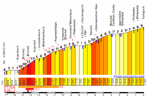
However the stage isn't over yet and there is still another 1st category climb to come, a mountain top finish on the Pfänder.
PfanderS.gif

The climb isn't extremely hard and only just 1st category. Still The first 5 kilometers are almost 10% steep so thats nothing to joke about. A good comparison for this climb is probably La Planche des Belles Filles. Moreover this is the last mtf of the race so the climbers should better use this chance to attack.
Pfaenderspitze_von_oben_01.jpg
 
I like that you're finishing a stage at the Bodensee, really fitting for a race through DACH. Also, I think the stage itself provides some opportunities for long range attacks, particularly with those steep final kilometers of Riedbergpass and the difficult to control terrain afterwards.
 
DACH Rundfahrt stage 15: Dornbirn - Schoppernau (133 km)
category: high mountain stage
7d82arM.png

OX2WXyX.jpg


The 2nd week ends with another mountain stage in one of the most underrated regions for cycling in Austria, the Bregenzerwald. The start is in Dornbirn and directly after the riders leave the city they will start climbing the first pass of the day, the Losenpass, also known by its local name "Bödele".
BodeleW.gif


The section after the descent until the intermediate sprint in Au is probably the easiest part of the stage and even these 20 kilometers aren't really flat and there is a 4th category climb, the Schnepfegg. However when the 3rd climb of the day starts after the riders have passed Au, the riders face 100 kilometers which are basically only up or downhill. The mentioned 3rd climb is the Furkajoch. From its other side it's probably the most western HC climb of Austria, from this side however it's only a 1st category ascent. That said, it's still anything but easy, quite long and although the average gradient of this pass isn't very high thats mostly because the climb is very irregular, a bit like the south side of the Glandon.
IMG_3332.jpg

FurkajochE.gif


After a very long descent the riders immediately have to climb the next 1st category climb, the Dünserberg. However this climb isn't quite as hard as the first two 1st category climbs of the day and quite close to only being 2nd cat. Nevertheless the climbing kilometers are adding up and the riders will start to feel how much they have already climbed. Moreover this stage is short so there is a good chance for a super high pace right from the beginning which would make this even harder and also more unpredictable.
The next two climbs are clearly easier. First the 4th category climb Thüringerberg which is probably the easiest pass of the day due to a gradient of under 5%, and then the Raggal which is both longer and clearly steeper than the previous ascent, and therefore 3rd category. While these climbs on their own wouldn't make a stage extremely hard they will make this one much more interesting since they are the reason why riders don't get one second of rest. And the gc contenders will have to be careful as well. Usually there aren't any long range attacks on 4th and 3rd category climbs but if a rider sees an opportunity and maybe has a teammate up the road they could blow the peloton up on this part of the race as well. Before the last climb starts the riders pass the golden kilometer where some gc contenders may already try to get some bonus seconds. Then the last climb of the day, the Faschinajoch starts.

faschinajoch_800.jpg

FaschinaSE.gif


(By the way, the first climb on the cyclingcols profile is the penultimate climb of my stage, the Raggal)
The Faschinajoch isn't very long but it has some brutally steep kilometers which are perfect for attacks. Especially after a whole day full of climbing the race could absolutely explode here. The Faschinajoch is actually a parallel pass of the Furkajoch and they share most of their north side. Therefore the last descent of the day will be on familiar roads. After the riders arrive in the valley they still have 5 kilometers to go, which will hopefully not frighten the potential attackers. The finish is in the skiing area Schoppernau.
1ece4cdff6.jpg
 
Right, this is basically a very vague idea for a Tour start in Denmark (because I don't think Copenhagen should have all the fun.)

Grand Depart Aarhus, the team presentation to be held at "Big Square" (Storetorv).

The race will kick off with a short prologue going up Randersvej, starting at the very bottom of the street. It will have to be short enough that it doesn't create too big time-gaps between the favourites, but still long enough to require an effort from the riders.

Stage 1 will then start in Aarhus and take the riders south towards Vejle, making sure to go over as many of the "climbs" on the way as possible. The stage will finish with a lap of the circuit used in the famous Vejle stage in the Tour of Denmark, of course finishing on the top of Kiddesvej.

The riders will then have a transfer across Jutland to the very South-Western part of the country where they will start stage 2. They will head south, and into Germany.
(And this is where my ideas run out.)
 
Deutschland Rundfahrt, 7. Etappe: Stockach - Freiburg im Breisgau: 204km, high mountains (to German standards)

1K04HTl.jpg


A short transfer brings the race caravan to the Northwestern tip of the Bodensee. The small town of Stockach will be the start of the queen stage of this tour of Germany (rather a tour of southern Germany from a hindsight).

640px-Stockach2005.jpg


The stage starts with an 80km long procession on the plateau of Baden-Württemberg before a gradual descent to the town of Kirchzarten sets in. Here, a bit before the halfway point, the hard part of today starts with the ominous named Notschrei (it more or less translates as "scream of distress"). Its overall statistics may not look very impressive, but its final 6 kilometers average over 8%.

qay6pwT.jpg


The 10km long descent is followed by some false flat before a 30km long section with some smaller climbs, of which the Weissenbachsattel (Hochkopf) is the most difficult.

cmPW1je.jpg


The next major climb is that on the flanks of the Belchen, using only the Hochtannpass and not going to the top.

rHhBv97.jpg


Its descent is immediately goes over in the final 7.5km (and most difficult part) of the climb to Schauinsland from Untermünstertal,with a stretch of 3km @ 11.7% before flattening out to the top.

YoMYUZs.jpg


All that's left today is a descent of 19km that starts twisty and steep, but eases off when it nears the city center of Freiburg.

Freiburg_017.650.n.jpg
 
Deutschland Rundfahrt, 8. Etappe: Freiburg im Breisgau - Pforzheim: 197km, medium mountains

Freiburg is the only city in this tour that has the honor to receive both a stage finish and start.

BrXswnI.jpg


From the outskirts of town the course follows the Elz river upstream, crosses the uncategorized northern flank of the Heidburgpass and descends in to the valley of the Kinzig to Offenburg. For the next 30km the course follows a scenic road through vinyards and forests with some minor climbs. This stage begins in earnest after a bit more than 100km, with the steep climb to the Buchkopf.The short but steep descent is met by the main climb of the day: the final 5 km of the west side of the Mehliskopf, averaging 9%.

LUzrP6l.jpg


The descents leads to the spa town of Baden-Baden and a final that goes up and down, but rarely stays flat, for the remaining 65km to Pforzheim.

640px-PF82s.jpg
 
DACH Rundfahrt stage 16: Lindau - St. Gallen (44 km)
category: individual time trial
Cx9AARl.png

1rL30dx.png


The final week of the DACH Rundfahrt starts with the 2nd and last ITT of the race. Since @Sestriere already liked the mtf near the Bodensee he will probably like this stage as well since I wanted to make a whole TT alongside a section the lake which is a border for all three countries. Therefore this will also be the only stage which takes place in Germany, Austria and Switzerland.
The start of the stage is on the beautiful island Lindau in the german part of the Bodensee.
hXR5cZZ.jpg


The riders ride along the lakeshore, cross the border and pass Bregenz, the capital of the Austrian state Vorarlberg. Here the riders will also pass the first time check. Unfortunately the only road which seems usable to me goes a bit southwards here which means the riders leave ride away from the Bodensee. After the athletes cross the border and pass the 2nd time check they will return to the lakeshore. The riders cross the town Rorschach and shortly after that they have to face the only climb of the day. Officially the climb starts in Goldach and ends at the finish in St. Gallen, the reality looks a bit different and the ascent ends around 4 kilometers earlier. However because the climbs are timed that would basically mean another time check extremely close to the finish and I don't think thats very exciting. Besides that you could also say that this should only be a 4th category climb and not 3rd category, but to make this at least a bit relevant to the mountain classification I decided to over categorize this climb a bit (just to remind you, there are double mountain points in ITT's). Maybe we would have riders who fight for the mountain classification who safe themselves for this part of the ITT and then sprint up the last 10 km. I think that could make the stage a little bit more interesting.
As I already mentioned the finish is in St. Gallen.
stgallen.jpg


This will be one of the crucial days for the gc. This TT is a bit longer than the first one and although there is a climb at the end this is definitely still a day for the TT specialists. This day will hopefully motivate pure climbers to attack on the mountain stages so far and to take some risks on the following stages in the 3rd week.
 
I've designed another Vuelta and thought I'd post here.
Too lazy to put the stages back again so you can view all stages but I'd prefer to post the stages one by one so don't look to the next stages. :D
La Vuelta a Espana Stage 1 Portbou-Sant Pere de Rodes Induvidual Time Trial with HTF 29,1 Km
https://www.la-flamme-rouge.eu/maps/viewtrack/hd/135857
KOM SPRINTS:
Coll del Frare (3rd Category, 200 m, 3.6 Km at 5.5%, Km 3.7)
Monestir de Sant Pere de Rodes (2nd Category, 520 m, 8.2 Km at 6.3%, Arrive)

INTERMEDIATE POINTS:
Coll del Frare (200 m, Km 3.7)
El Port de la Selva (10 m, Km 20.4)

The Vuelta opens with a TT, on the north-east of Spain, on the city that is very close to French border, Portbou.
Portbou:
portbou.jpg


There are two climbs in the time trial, one at the finish.And both climbs will award mountain points. And the first climb of the day, Coll de Frare (3rd category), 3,6 km at %5,5 starts directly from Portbou.
Coll de Frare:
695-frare-portbou.gif


At the top of the climb we may see who is going for the GC and who is not. Then after the descent and small bumps there are some flat kilometers. At Port de la Selva, 20,4 km, we will have the second time check of the day.
After the checkpoint the second and final climb of the day, Sant Pere de Rodes starts. It is a 2nd category climb and the finish is on top of the climb. This stage should make some gaps already, and the GC riders who are not on form yet can lose important time here.
Monestir de Sant Pere de Rodes:
Rodes500.JPG

sant-pere-de-rodes-39.jpg
 
La Vuelta a Espana Stage 2 Roses-Santuari de Bellmunt 174,5 Km MTF
https://www.la-flamme-rouge.eu/maps/viewtrack/hd/135991
KOM SPRINTS:
Coll de Bucs (2nd Category, 773 m, 4.3 Km at 8.5%, Km 75.7)
Coll de la Boixeda (2nd Category, 1091 m, 12.3 Km at 4.9%, Km 99.6)
Coll de Bracons (1st Category, 1127 m, 7.8 Km at 8.2%, Km 152.9)
Santuari de Bellmunt (1st Category, 1227 m, 7.2 Km at 8.8%, Arrive)
Stage 2, and we already have our first MTF!
The stage starts in Roses.
Roses:
EUROPEMEDITERRANEANSPAINCON_ESPCOSTABRAVAROSASRES_003798.jpg


The first climb of the day is Coll de Bucs, a 2nd category climb, 4,3 km at %8,5 with max gradient at %13. (counting the false flats it becomes 7,8 km at %5,2) :
bucsxoix.png


Then we have our second climb of the day, Coll de Boixeda, a 2nd category climb, 12,3 km at %4,9 with some pitches at %11-12:
boixedaxbeget.png


With less than 30 km to go things get difficult since we start the first 1C climb of La Vuelta, Coll de Bracons, 7,8 km at %8,2 with max gradient at %14. (counting the false flat, it becomes 8,6 km at %7,6 but I don't count it) Some teams can set a hard pace to eliminate some contenders. The top of the climb is crested with 21,5 km tothe finish.
Coll de Bracons:
bracons02.PNG


After the irregular descent we have the final climb of the day, Santuari de Bellmunt, 7,2 km at %8,8 with max gradient at %24 inside the final kilometer! And there are also pitches of %15-16 on the first half of the climb. And there are some kilometers over %11. And to add insult to the injury, the final part of the climb are on hormigon! There should be definitely some gaps here. And if some riders go as early as Bracons, they can be big.
Photos from the road of the climb to Santuari de Bellmunt (photos of the road taken from APM) :
9769ac0c87fe76af708333309bf7fbd9o.jpg

3961ad43e34c2db371beb15189c6c5eco.jpg

Santuari de Belllmunt:
bellmunt.PNG

santuari.jpg
 
La Vuelta a Espana Stage 3 Vic-Barcelona (Montjuic) 157,73 km Hilly with Uncategorized Uphill Finish
https://www.la-flamme-rouge.eu/maps/viewtrack/hd/135860
KOM SPRINTS:
Coll de la Pullosa (3rd Category, 924 m, 12.1 Km at 3.4%, Km 18.1)
Col d'Estenalles (2nd Category, 869 m, 7.6 Km at 4.9%, Km 57.2)
Creu d'Aragall (2nd Category, 516 m, 6.3 Km at 5.7%, Km 105.1)
Can Rafael (3rd Category, 375 m, 2.3 Km at 7.9%, Km 114.1)
Santa Creu d'Olorda (2nd Category, 419 m, 8.7 Km at 4.5%, Km 132.7)
Tibidabo (3rd Category, 502 m, 2.5 Km at 7.0%, Km 139.4)
Montjuic (4th Category, 132 m, 1.9 Km at 6.8%, Km 154.3)

The 3rd stage starts in Vic:
aerial-view-view-of-the-historic-centre-vic-catalonia-spain-e7tepy.jpg


There are 2 climbs in the first half of the stage. Firstly, Coll de la Pullosa, 12,1 km at %3,4 a 3rd category climb. This climb should create the break. Then comes Col d' Estenalles, 7,6 km at %4,9, a 2nd category climb thoughsince there is a short descent on the climb which makes the stats look easier.

With less than 60 km to go the thing start to get hard. Firstly the ascent of Creu d'Aragall, 6,3 km at %5,7 with pitches up to %10-11 (I think the first km on the profile is not ridden on the stage). A 2nd category climb.
creuaragall01.PNG


The next climb of the day is Can Rafael. A 3rd category climb which is 2,3 km at %7,9
Can Rafael: (From km 4 I think)
298-can%20rafel-corbera.gif


Then comes Santa Creu d'Olorda, another 2nd category climb. 8,7km at %4,5 with the steepest km at %6,5.
SCOlorda.gif


After a short descent and a small bump, Tibidabo starts. 2,5 km at %7 it is a 3rd category climb with the last 800 meters at %10,6.
Last 2,5 km of this profile:
Tibidabo1.gif


The top of Tibidabo will be crested with a little more than 18 kms to go. After the descent and false flat the final part of the stage starts. Since there are tons of road around Montjuic I couldn't find the profile of the one I'm using. But the last categorized climb of the day, Montjuic is 1,9 km at %6,8, a 4th category climb. The top of the climb is crested with 3,4 km to go. After a very short descent the final 1200 m are ascending again at around %3,75. The finish is on the top of the uncategorized hill at the stadium of Montjuic. This stage should be on the radar of stagehunters and punchers-Sagan type sprinters who are here to prepare for WC. There can also be some GC gaps if a GC contender attacks or gets caught behind the splits.

Barcelona-Estadio Montjuic:
86_big.jpg
 
Pretty please include the image of the profile of the stages in the actual post instead of forcing us to click the links. It's annoying as hell.

Interesting start though with a long time trails and mountains immediately. Care to elaborate on that?
 
Re:

jsem94 said:
Pretty please include the image of the profile of the stages in the actual post instead of forcing us to click the links. It's annoying as hell.

Interesting start though with a long time trails and mountains immediately. Care to elaborate on that?
I don't use tinypic. Photobucket has deleted many photos of many users and Imgur is blocked on my country. Matter of preference as well imo.

I started directly with a TT and then a MTF because I don't like backloading and want a race to be interesting for 3 weeks. I have 2 more 1C MTFs in the first week and then there is a 3C uphill finish in a hilly TT in the 2nd week and another 1C MTF in the final week. I have lots of descent finishes though.
 
Apr 27, 2017
86
1
1,685
I use Imgbox, it's a bit unknown but it says that images won't get removed. Before that I used Imgsafe, but that site was down for some time. (Those sites better not die from over-exposure, like many small image hosts...)
 
jsem94 said:
Imgur usually works for me. Where are the flat stages though? Gotta give the sprinters something.
Coming now:
La Vuelta a Espana Stage 4 Barcelona-Lleida 180,9 Km Flat
https://www.la-flamme-rouge.eu/maps/viewtrack/hd/137633
A flat stage for sprinters. The last time a GT stage finished in Lleida, it was the 12th stage of 2015 Vuelta, which was won by Danny van Poppel. There was also a stage finish in Lleida in the 12th stage of 2010 Vuelta, which was
won by Mark Cavendish.
Barcelona:
barcelona-1080x675.jpg


Lleida:
lleida-ciutat-vistes.jpg
 
Re:

jsem94 said:
Imgur usually works for me. Where are the flat stages though? Gotta give the sprinters something.
Why? If you can avoid sprinter stages, by all means, do not include them! What are they good for anyways, I mean, why do we have to please them when its awfully boring to look at no matter what? ;)
 
rghysens said:
Deutschland Rundfahrt, 4. Etappe: Weiden in der Oberpfalz - Grosser Arber: medium mountains, 150km

A 60km transfer brings the race caravan from the finish of stage 3 to the start of stage 4.

Y460hZm.jpg


Weiden in der Oberpfalz is a medium sized bavarian town, close to the border with the Czech republic.

800px-Weiden_Oberpfalz_22_Mai_2016_01.JPG


The whole stage will run more or less parallel to this border, with the finish only a couple of kilometers from the border. The first 40km are on generally rolling roads, with several uncategorised and one categorised climb. None of them are difficult, but the elevation gain of 700m in the first part of the stage may see a strong breakaway go clear. The middle part, fifty more or less flat kilometers will probably mean a status quo in the course development. The crossing of the Weisser Regen river in Bad Kötzting sees a change in terrain: no more flat or rolling roads, but some rather steep, but short climbs. While the course winds its way through the Bayerischer Wald, the first mountain pass (albeit a not too difficult one) of the race is crested. The Eck (or Ecker Sattel) snakes between the summits of the Kleiner Riedelstein and Mühlriegel to an altitude of 843m.

PXy2u50.jpg


Its descent and 10km uphill false flat lead to the main difficulty of the day: the climb on the Arberstrasse, to the summit of the Hahnenriegel. This irregular climb delivers the first opportunity for the climbers to make up for time lost in the first two stages. The first three kilometers of this climb have sustained sections of nearly 10%, with a maximum of 19%.

33BlEOR.jpg


The short descent leads to a final, uncategorised bump of 2km @ 5%, that ends with 1.5km to go. The finish is near the wintersport facilities on the slopes of the Grosser Arber, the highest peak of the Bayerischer Wald.

800px-Gro%C3%9Fer_Arber.jpg

Why wouldn't you go to the top of Arber? There's a wide gravel road that leads up to about 1440m that ends at the Military facilities. The final 2.5km are about 10%.

arber-radarkuppel-radomen-technik-800-300x225.jpg
 
La Vuelta a Espana Stage 5 Balaguer-Aramon Cerler 215,2 Km MTF
https://www.la-flamme-rouge.eu/maps/viewtrack/hd/136664

KOM SPRINTS:
Port d'Ager (3rd Category, 901 m, 5.6 Km at 5.4%, Km 26.7)
Coll d'Ares (1st Category, 1531 m, 14.0 Km at 6.6%, Km 46.0)
Coll de Montllobar (2nd Category, 1046 m, 10.1 Km at 4.9%, Km 78.7)
Coll de la Creu de Perves (2nd Category, 1329 m, 7.8 Km at 5.6%, Km 131.1)
Coll de l'Espina (2nd Category, 1429 m, 6.7 Km at 6.2%, Km 165.6)
Ramastue (2nd Category, 1385 m, 7.9 Km at 5.4%, Km 189.1)
Cerler-Ampriu (1st Category, 1936 m, 12.0 Km at 6.2%, Arrive)

A very tough mountain stage with 6300+ m of climbing in 215 km. (Though the real climbing is less than 6300 m as there are some tunnels)

First climb of the day is Port d'Ager. It is 3rd category since I only categorized the last 5,6 km but the part before it is hard with multiple short ascents and descents. There are some pitches with %13 on the final 5,6 km.
Port d'Ager:
portager27.gif


The second climb of the day is Coll d'Ares and it is a 1C climb. 14 km at %6,6 with sections at %10-11 should do some damage on both breakaway and peloton if the teams set a hard pace from early on.
Coll d'Ares:
lleidaaressur02.gif


Then comes Coll de Montllobar. It is a 2nd category climb with 10,1 km at %4,9 with %8 max.
Coll de Montllobar (The climb starts in the Puente de Montanana intersection) :
MontllobarW.gif


After the descent of Montllobar there is a pretty long flat and false flat part before our next climb, Coll de la Creu de Perves. 7,8km at %5,6 with the max gradient at %10.
Coll de la Creu de Perves (all of it is ridden, but only last 7,8 km categorized) :
ll38.png


Things get more serious with 5th climb of the day which is Coll de l'Espina. 6,7 km at %6,2 with max gradient of %10 it is another 2nd category climb. It is crested with 49,6 km to go.
Coll de l'Espina (all of it is ridden, but only categorized till Espina) :
espina.gif


The penultimate climb of the day is Ramastue, another 2nd category climb. The stats for the climb 7,9 km at %5,4 but it is irregular and has a descent part so it is harder than it looks. It is crested with 26,1 km to go.
Ramastue (only from the intersection with Bisaurri (which is around km 2,2 or so)) :
6686c9cb.jpg


After the descent and some false flat, time for the final climb of the day, Estacion de Esqui Aramon Cerler. 12 km at %6,2 it is a worthy 1C climb and it is harder than it looks because it has some descent parts and is very irregular. The last winner here is Leonardo Piepoli in 2007. Also Roberto Laiseka won here in 2005 and Jose Maria Jimenez (RIP) in 1998.
Aramon Cerler (all of them ridden, last 12 km categorized) :
cerler-ampriu.gif


Balaguer:
rio_segre_balaguer_t2500314.jpg_369272544.jpg


Estacion de Esqui Cerler-Ampriu:
cerler.jpg
 
Oct 4, 2015
417
1
3,030
Tour de France Stage 20: La Côte-Saint-André - Saint-Étienne, 147km
7bip.png

11rq7vt.png

Climbs: Croix-de-Montvieux (cat. 2), Croix-de-Chaubouret (cat. 1), République (cat. 1)

The final, fairly short medium mountain stage of the Tour (and the final stage before the typical journey to Paris) takes us back into the Massif Central, for an old classic finish in Saint-Étienne.
The stage starts off flat/somewhat hilly as we head west towards the Rhône, until we finally cross the river and, almost inmediately after, start the first climb of the stage, the Col de la Croix de Montvieux. Fairly long, but very shallow, so riders won't feel very threatened here.
CroixDeMontvieuxE.gif

After this comes a harder climb, the Col de la Croix de Chaubouret. Similar length, but slopes at around 6-7% instead of 4-5%. A good point for desperado attacks by any rider with nothing to lose (although, as we have seen in recent similar stages, the key attacks may happen anywhere, even at the uncategorized climb at the beginning of the stage. Or at Montvieux).
CroixDeChaubouretN.gif

Then, we have the Col de la République, also known as Col du Grand Bois. This was the first climb above 1000m ever climbed in the Tour, back in 1903. And, while it may have been a fairly remarkable milestone back then, nowadays it's just considered a pretty average climb; fairly long, but shallow, and with its hardest slopes coming in early. If anyone wants to "save up" for this climb, they will likely get nothing done, but if the group has already broken apart earlier it's still hard enough to make the job very difficult for struggling riders trying to catch up with attackers.
GrandBoisE.gif

After République it's (mostly) downhill until the finish line in Saint-Étienne. A final chance for climbers to try and shake up the GC, but probably not hard enough for them to achieve their goal (unless the leader gets careless). Other than that this could be an interesting duel between stage-chasers, with some riders trying a long-range breakaway and some probably making their moves at any of the categorized climbs later in the stage.
 

TRENDING THREADS