Race Design Thread

Page 281 - Get up to date with the latest news, scores & standings from the Cycling News Community.
Re: Re:

Libertine Seguros said:
Afraid the climb you've labelled as El Portillón there isn't El Portillón - that's the climb to the north of the one you've used, which is only really a cat.3. Even though it's labelled as a major road, the one you've used - the CA-712 - is in long sections completely unpaved and the descent would be possibly even more dangerous than descending Los Machucos.

8.jpg


(that's just the hormigón bit around the village of Sel de La Carrera - it gets worse higher up and has ramps over 25%. I certainly wouldn't want to be descending on that kind of gradient on gravel and hormigón on a road bike).

If you wanted to maintain the difficulty, you could perhaps go with, from Arenas de Iguña, Collada Brenes (6,3km @ 8,7%) then the easier El Portillón climb (cat.3) before La Braguía. Or you could use the normal version of El Portillón, or skip the Los Corrales de Buelna part entirely, go direct from Torrelavega to Puente Viesgo, then climb parallel to El Portillón on the climb to Quintana de Toranzo, which would then descend and connect to Escudo similarly to your current stage.

If you felt that sacrificed too much of the difficulty, you could always use La Estranguada instead of Caracol - a bit more of a gap after La Braguía, but slightly closer to when you start climbing La Sia too.

Thanks! I was wondering about that last night. Found out after I posted that Portillon was further north, and couldn't find any info about the climb I used. Since it seemed to be marked as a bigger road on google maps, I thought it was in ok condition.

Will update the stage during the weekend.
 
Just as Vuelta finished and LS finished his Benelux expeditions.

Giro d'Italia – Zomegnan/fanservice/crowd-pleaser edition.

Just decided to have fun and Italy is best for having fun (you shall quote this #hypnosis). There are still like over 9000 random muritos left unused. Some stuff is more popular and just wanted to have a crack at it myself, some is less known. As a GT it's not really good, as i think some stages could switch places and plenty of them will be underraced. It's more a collection of ideas than a thought-out tour. I could do just a mountains galore, but Eshnar already did it a couple of years ago, so i don't want to copy his idea.

There are plenty of mountain stages, but only 3 MTFs, of which 2 are optional. First week in south Italy is difficult, but it's not a case of like allready winning the whole race, rather losing a lot of time, when off-form. Last two weeks are quite similar to each other – a slower build-up towards weekend in mountains. There are almost 100km of ITT + prologue. Hence, the overall length of the race is very short – just under 3300km. There are only 4-5 sprint stages.

Because this race doesn't even pretend to be realistic, this time i decided to skip the details of each stage and focus the post on the climbs themselves and just to explain, what i could expect from each stage.

Giro d'Italia. Isola di Capri CRI, Capri – Anacapri, 3,2km, prologue.
https://www.la-flamme-rouge.eu/maps/viewtrack/hd/150437
Qd5B8hI.jpg


1024px-Capri_coastline.jpg

Capri.

The race kicks off with a prologue in a beautiful Capri island. It's mainly home to some very steep drops, balcony roads and hanging houses, Cuenca style. I decided to use the Via Provinciale Anacapri – one of the best balcony roads in Europe. Most of this prologue takes between a steep drop to the Tyrrhenian Sea and Monte Solaro, home to Castello Barbarossa (not named after a famous German Emperor but an Ottoman admiral Hayreddin).

uhh8Ruo.jpg

Castello Barbarossa.

I cannot showcase the road by randomly posting pictures, so if you're interested in it, check it out for yourself. Here are small samples:

FxBus3N.jpg

nFwAWr4.jpg

Via Provinciale Anacapri.

The race starts in the town of Capri, on Piazza Umberto 1, also known as Piazzetta, which is probably the biggest open space on the whole island (it's still tight though). The stage then leads through Capri to Via Provinciale Anacapri and then uphill (2,8km at 4,8%) to Anacapri, where the finish is on Piazza Vittoria.

www-delightfullyitaly-com-capri_faraglioni-walking-tour_2.jpg

Piazzetta, Capri.

1024px-Piazza_Vittoria_din_Anacapri.jpg

Piazza Vittoria, Anacapri.

How realistic is this? Maybe 50 years ago it wouldn't be a big problem, but i fear there's just not enough space available.

I'll try to post each stage every day, but there may be some delays, but there shouldn't be bigger than a day unless i'll have a major power/Internet failure.
 
La Vuelta a Espana Stage 18 Plasencia-El Travieso 188 Km MTF
https://www.la-flamme-rouge.eu/maps/viewtrack/hd/106842

KOM SPRINTS:
Puerto del Piornal (1st Category, 1269 m, 14.5 Km at 5.0%, Km 55.4)
Puerto de Tornavacas (2nd Category, 1276 m, 13.6 Km at 4.9%, Km 100.7)
Puerto de Tremedal (2nd Category, 1636 m, 11.9 Km at 4.6%, Km 120.7)
Alto de la Hoya (4th Category, 1286 m, 4.7 Km at 4.2%, Km 136.2)
Puerto de la Garganta (2nd Category, 1313 m, 10.4 Km at 5.6%, Km 169.9)
El Travieso (1st Category, 1837 m, 9.9 Km at 7.4%, Arrive)

A day for the GC with a MTF at El Travieso.

The first climb of the day is Puerto del Piornal. 14,5 km at %5 with max gradient of %14, it is overcategorized as 1st category to encourage more riders to the break.
Piornal (all of it ridden, only last 14,5 km categorized) :
Piornal1.gif


The second climb of the day is Puerto de Tornavacas. With 13,6 km at %4,9 it is a 2nd category climb.
TornavacasS.gif


The third climb of the day is Puerto de Tremedal. With 11,9 km at %4,6 it is another 2nd category climb. I couldn't find a profile of the side I climbed but the road i asphalted and the asphalt is in good condition.
But it shares the last 5,5 km from Solana de Avila intersection with this:
TremedalS.gif


Then comes the easiest climb of the day, Alto de la Hoya. 4,7 km at %4,2 it is only a 4th category. It shares the last 3,4 km with this:
HoyaE.gif


The 5th climb of the day is Puerto dela Garganta. With 10,4 km at %5,6 with a max gradient of %10 it is another 2nd category climb. This can be a nice launch-pad for a desperate attack.
The first km of the profile may not be climbed, not sure about it:
GargantaS.gif


The final climb of the day is El Travieso. With 9,9 km at %7,4 with stretches of %11-12-13 it is the hardest climb of the day and a definite 1C.
El Travieso (Only from the intersection with La Garganta at km 5 or so) :
trav_bej_16.png


This is the last MTF of the race so the riders better make use of it.

El Travieso:
la_ceja_1.JPG
 
Previous stage: link

Giro d'Italia – stage 2. Amalfi – Paestum, 189km, hilly.
https://www.la-flamme-rouge.eu/maps/viewtrack/hd/149814
zs8bmIA.jpg

TIb7BHx.png


Climbs:
Picco Sant'Angelo – 8,5km, 4,7%, cat. 3, 472m
Ogliastro Cilento – 3,8km, 7,7%, cat. 3, 307m
Trentinara – 9,3km, 5,5%, cat. 2, 570m

Back to the mainland. Start is in Amalfi, on Piazza Flavio Gioia. Amalfi is a beautiful town and a famous summer resort squished on the coast of Sorrentine peninsula, topped by Arab-Norman Romanesque Cattedrale di Sant'Andrea from XI c.

B6HxXDo.jpg

Amalfi.

Duomo_di_Amalfi.jpg

Duomo di Amalfi.

First 25km to the first categorised climb of the day – Picco Sant'Angelo goes alongside the well known Amalfi coastal road (SS163). Next 70km to Salerno goes around the peninsula visiting Sorrento, Pompeii and Cava de' Tirreni.

2JqnOv9.jpg

Coastal road near Amalfi.

1024px-View_of_Sorrento.jpg

Sorrento.

1024px-Ruins_of_Pompeii_with_the_Vesuvius.jpg

Pompeii.

SalernoCanalone.jpg

Salerno.

Next 50km from Salerno go alongside the Tyrrhenian coast on Piana del Sele to Agripoli. Last 50km are in north Cliento, on the foothills of Monti Alburni. The last 56km are on a lap south of Paestum. The first passage through the finish line is an intermediate sprint. Finish is near the archaelogical site of Paestum, on Via Magna Graecia, at the end of a 160m straight. The site, in the ancient Greek known as Poseidonia, is mainly known for very well preserved three ancient Greek Poseidon and Hera temples.

portodiagropoli_slider_4.jpg

Agropoli.

1024px-Visione_aerea_da_mongolfiera_dei_templi_di_Era_e_Poseidone.JPG

Paestum.

The last lap south of Paestum can be tricky. It has two categorised climbs – a short, but steep (max ~14%) climb to Ogliastro Cilento and a longer, but softer (max 9%) climb to Trentinara.

xqON1qd.png

Ogliastro Cilento (excluding the last 1km).

WLurjt4.png

Trentinara.

sq11VZK.jpg

View from the top of Trentinara.

The top of Trentinara is 21km from the finish line with the last 7km flat. The descent is not steep, between 5-6% (similar to the ascent) but, like most roads in Italy, can be technical with 8 serpentines, plenty of turns and a slightly narrower bit through Capaccio.

anwwu0K.jpg

Descent from Trentinara with Monte Soprano in the background.

castello_capaccio.jpg

Castello di Capaccio.

I don't expect Trentinara to be too selective, but with a relatively technical, yet shallow descent an outsider could try to seize the maglia rosa, even if just for the next two days. Maybe a breakaway could use the descent to it's advantage as i guess GC guys will be happy to stay protected and ride it very carefuly. The last flat 7km to Paestum could be crucial, as they're very straight (only 3 turns). If not the breakaway, then a reduced bunch sprint for the likes of Felline. Back, when he was still active, "Puma" Garzelli would probably be happy to win such a stage.

Next stage is for sprinters, but the last kms are slightly uphill. Because there's not much to the next stage i decided to post it here.

Giro d'Italia – stage 3. Sapri – Nicastro. Lamezia Terme, 168km, flat.
https://www.la-flamme-rouge.eu/maps/viewtrack/hd/149853
2G3Dopz.jpg

G6xiP3d.png


Climbs:
Paola – 3,8km, 3,8%, cat. 4, 150m

The entire stage goes alongside the Tyrrhenian coast from Campania to Basilicata on SS18, also known as Strada Tirrena Inferiore. Finish is in Nicastro, now (since 1953) part of a bigger creation (with Sambiase and Sant'Eufemia Lamezia) known as Lamezia Terme. Nicastro is the biggest part of the municipality. The finish line is on Via Cristoforo Colombo, at the end of a 430m straight. The run-in is slightly uphill with a 4km at 3,2% climb to Sambiase and last 6km to Nicastro a bit easier. I guess it'll end in a bunch sprint but maybe some Rebellin or Garzelli token will try for a lower top 10 spot.

1024px-Specola_Astronomical_Observatory_in_Sapri.JPG

Sapri.

9061059.jpg

Nicastro, Lamezia Terme.

ZzNj0Ti.jpg

Coastal drive near Sapri.

I decided to not use any of the muritos north and east of Nicastro, as the next two stages will be in the mountains (@Zam_Olyas should be happy), so i don't see the point of including a murito finale here.
 
jsem94 said:
Beautiful start so far!
Thanks a lot. I like the idea of a ~10km Prologue/ITT followed by a hilly stage with a technical finale. GC guys will play the safe card, while an outsider could try to risk a bit and fight for the leader's jersey or just limit the loses from ITT. I guess such scenario works only in my head. Interestingly, i think it was 1977 Giro, when on a smilar stage GC guys gave a pass to De Muynck (who was 2nd in 1975), and he managed to protect his advantage up to Venice (i think it was the grande finale in 1977). Of course in this day and age it won't happen, but for a non-gc guy or even an outsider wearing Maglia Rosa for 2 days should be thrilling enough to take some risks and try to push for the stage win. I hope i explained my thought well enough.

First form-check stage. If you're still a bit off-form, you can lose a lot of time.

Previous stage: link

Giro d'Italia – stage 4. Nicastro. Lamezia Terme – Camigliatello Silano, 211km, mountain.
https://www.la-flamme-rouge.eu/maps/viewtrack/hd/149887
YSPkwvC.jpg

EtiHzh7.png


Climbs:
Passo Condrò – 17km, 5,2%, cat. 2, 1050m
Valico di Carlopoli – 5km, 6,2%, cat. 3, 972m
Pentone – 5,2km, 4,5%, cat. 4, 838m
Valico di Tirivolo – 15,6km, 6,8%, cat. 1, 1509m
Valico di Monte Scuro – 24km, 5,7%, cat. 1, 1618m

This stage ventures in La Sila mountains, utilising the hardest climbs of Sila Piccola and Sila Grande i could find. Both climbs, that i've managed to find aren't the toughest in the world, but they're hard enough for a Giro cat. 1, and you really, really need to earn a Giro cat. 1. It's not TdF with Latrape bullcrab.

Riders will stay overnight in Nicastro, where this stage starts. Then they'll head away from the coast through Sila Piccola (represented mainly by Monte Gariglione, 1765m) north of Catanzaro, and then stay for roughly 40km on a plateau before going down to Cosenza, leaving Sila Piccola for Sila Grande. On this stage Sila Grande is represented by Monte Botte Donato (1939m), Monte Curcio (1788m) and Monte Scuro (1633m).

0OHSr6E.png

Passo Condrò.

Cosenza_views_915.jpg

La Sila.

Finish is in Camigliatello Silano – a small ski station and one of the main mountain resorts of La Sila. The finish is on Via Falcone e Borsellino, at the end of a 380m straight. It was once a Giro finish in 1982 on a stage won by Bernard Becaas from a breakaway. The last climb was a much easier drag to Silvana Mansio.

Camigliatello.JPG

One of the very rare photos of Camigliatello Silano.

1024px-Panorama_Comune_Taverna.JPG

Taverna.

1881069.jpg

Albi.

The stage also visits one of the biggest cities in Calabria – Cosenza. This very picturesque city located on the fork of Crati and Busento rivers is mainly known for it's very long, commercial straightaway Corso Mazzini, a XIII c. gothic Cattedrale di Santa Maria Assunta, Chiesa di San Francesco di Paola and hilltop Castello Svevo patronized by Frederick II.

1024px-CS_Alba_19.07.2012.jpg

Cosenza.

Castello_svevo_cosenza.jpg

Castello Svevo, Cosenza.

The main features of this stage are two cat. 1 climbs to Tirivolo and Monte Scuro. Both are borderline TdF HC cat. climbs. Tirivolo is narrower and more irregular with some easier and tougher parts up to roughly 14%, while Monte Scuro (or Montescuro) is a regular 6% drag with easier 4km at 3-4% followed by 1km at 10% (max 14%). Last 13km are at constant 6%. The top is 10km from the finish line. The descent is wide and not steep (6%), but quite technical with 3 serpentines and plenty of turns. Last 4km from Moccone are flat-ish.

0AHdBjb.png

Profile of Tirivolo, starting from 3km mark.

MontescuroW.gif

Profile of Monte Scuro.

Monte Scuro should work well with any of the climbs (there are plenty of these) in Catena Costiera between Cosenza and the Tyrrhenian coast. Monte Cocuzzo with 15km at 7,2% is probably the tastiest while easier Passo della Crocetta is probably the prettiest. There's also an alternative (and slightly tougher) side of Monte Scuro from Quattromiglia, but it includes a very, very bad sterrato section (it's basically just a mountain path).

What could be expected? I doubt you could won the entire race on this stage, but you can lose it. I guess it'll be a Sky-esque uphill train with roughly 10-man group at the top and probably on the finish line. Maybe someone will try for a testing push in the last 2km and then keep the pressure on the descent. The GC group should have a quite significant (maybe even over 1 min) lead over the next group. I guess a guy like Esteban Chavez would be a favourite to win.

The next stage is very similar to this one, but rather than two serious climbs it'll have only one, but harder than the ones on this stage.
 
Previous stage: link

Giro d'Italia – stage 5. Corigliano Calabro – Castrovillari, 215km, mountain.
https://www.la-flamme-rouge.eu/maps/viewtrack/hd/150031
zbFf54f.jpg

4uEN8qU.png


Climbs:
Prato di Amendolara – 7,2km, 4,7%, cat. 4, 351m
Valico di Farneta – 9,8km, 4,7%, cat. 3, 781m
Monte Tumbarino – 10,3km, 5,7%, cat. 2, 1090m
San Severino Lucano – 14km, 3,6%, cat. 3, 862m
Colle Ruggio – 16,5km, 7,6%, cat. 1, 1602m

This time it's yet another over 200km stage (2 of 3) with a profile kinda resembling a more spread out (mainly longer descent) version of Bagnères-de-Luchon after Port de Balès. I guess the outcome will be similar to the previous stage to Camigliatello Silano. Maybe the GC group will be slightly bigger. Last 50km should be interesting to watch, as Colle Ruggio is a tough *** and it should do a major selection in the peloton.

It's the 2nd stage in Calabria, but it also features a bit of Basilicata. This time the stage is mainly on the Ionian coast. The stage starts in Corigliano Calabro. This hilltop town is known for a very nice looking Norman Romanesque ducal castle from XI c. Later it was renovated in Aragonese in XVI c. Near the town there is also an ancient Greek archaelogical site of Thurii and Sybaris.

Corigliano_Calabro-Vista.jpg

Corigliano Calabro.

castello-corigliano-1.jpg

Castello Ducale, Corigliano Calabro.

1024px-Sybaris_archeological_park_1.jpg

Sybaris.

First 40km to Marina di Amendolara are alongside the Ionian coast on a regional road parallel to E90, before turning inland towards the Pollino massif (highest peak – Serra Dolcedorme, 2267m). The finish line is in Castrovillari on Corso Giuseppe Garibaldi, at the end of a 240m straight.

IDHXhUf.jpg

Pollino.

c8K6As3.jpg

Morano Calabro.

72978884.jpg

Castrovillari.

I've seen Castrovllari being used plenty of times, especially after hosting a stage to Alberobello in 2017. However, i've never seen a stage to Castrovillari using the Pollino massif. Maybe it's because i'm blind, or the search system on this forum sucks. Maybe Morano Calabro could also host a finish... i actually just now realised this option exists. Morano Calabro is a hilltop town roughly 8km from Castrovillari, but it lacks any space. I guess Castrovillari is a more realistic option then.

This stage is all about the last 50km. First 16,5km are uphill to Colle Ruggio – part of a bigger system including Colle dei Dragone and Colle d'Impiso near Sierra del Prete (2181m) – western part of Monte Pollino (2248m). The side i've chosen is a narrowish, but very scenic side from Rotonda. I've decided to spice things up a little by chosing a different approach to Rotonda using a narrowish murito from Fiume Mercure, which is 2,7km at 7,6% (max 16%). Other very tough part is a 7km section in the middle to Riff. Frasanelli at 9,4% with 1km at 12%. The whole climb is quite irregular, with at least two plateaus and 3 tougher sections (last one near the top).

0SuWX5w.png

Profile of Colle Ruggio.

SWznH6e.jpg

A tough section to Rotonda.

RYj7ywo.jpg

Pollino seen from Colle Rugio.

From the top the next 2km to Colle dei Dragone are on a plateau. The descent from Dragone is realtively wide, but the surface is not in the best of conditions. This descent is very long and it's broken into 2 parts. The first one lasts 12km and leads to Campotenese. The 2nd one leads to the finish line and is 16km long. Overall, it's 35km. None of the sections are very steep (max 8%), but they can be tricky. The 1st section has 8 serpentines while the 2nd one has 5 serpentines, a large (protected) drop on it's side and a passage through Morano Calabro. While there are some technical bits, i assume it's mainly a power descent.

jdXYaC3.jpg

Descent from Colle Ruggio.

I assume there'll be some skirmish and testing pushes from the GC group on Colle Ruggio, but i don't expect anyone winning the race, as everything should come back on the descent. However, if you're out of form, you can lose big time. The next stage is much easier even if on paper it looks tougher than it really is.
 
Re:

Forever The Best said:
Awesome to see Colle del Dragone. I'm also designing a Giro and completed 16 stages of it. And my stage 20 will have around 100 km of sterrato. :eek:
I like your stage 4 a lot as well.
I don't really know how many people used Dragone at all or the Rugio side of Dragone as the search system on this forum doesn't work for me. Maybe i'm typing wrong tags. Next stage should be tomorrow, as now i'm going lulu.

I think i've just stumbled upon your sterrato stage and i can admit, the profile is very gray. Also, the current version of this stage is really long :exclaim: . I only have 28km in two stages. I hope i did not spoil too much.

Previous stage: link

Giro d'Italia – stage 6. Castrovillari – Potenza. Poggio Tre Galli, 198km, medium mountain.
https://www.la-flamme-rouge.eu/maps/viewtrack/hd/150337
4wZqPHD.jpg

VoFsZpm.png


Climbs:
Valico di Campotenese – 10km, 5,2%, cat. 2, 1038m
Valico di Prestieri – 14km, 4%, cat. 3, 841m
Valico di Pecorone – 7,7km, 4,5%, cat. 2, 908m
Tuppo delle Seti (Sacro Monte di Viggiano) – 14,8km, 4,8%, cat. 2, 1307m
Valico della Sellata – 8km, 5,8%, cat. 2, 1262m
Ferretto – 4,5km, 6,2%, cat. 3, 1090m

This stage goes through Appennino Lucano in Basilicata, known mainly for Monte Sirino and Madonna di Viggiano. This stage just misses both climbs. The start is in Castrovillari and the first 15km to Campotenese goes in the opposite direction to the last stage. This time riders can admire the views.

CampoteneseE.gif

Valico di Campotenese.

wmQhuVU.jpg

Monte Pollino seen from Campotenese.

Finish is in the capital of Basilicata – Potenza. Because i had issues with lack of space in the historical centre and the next stage will start in Potenza anyway i decided to finish on a 200m at 12% murito (it's roughly 1km long, but the rest is more of a false-flat) in Poggio Tre Galli (Monte Cocuzzo, 794m) district, on Viale Vincenzo Verrastro, while the historical centre can be reserved for the next stage.

1eMlkrz.jpg

Finish in Potenza.

Potenza_Piazza-Mario-Pagano_Basilicata-da-vedere.jpg

Potenza, Piazza della Prefettura.

On the profile this stage looks very tough, but all of the climbs are quite shallow. They're also very regular, so i expect it being more of a breakaway stage. Maybe some teams could try to do some damage on Ferretto, which is the steepes climb of the day with small patches of 8-9%. The top of Ferretto is 12,5km from the finish line.

PvQgw4K.png

Tuppo delle Seti.

nBzcJYf.png

Valico della Sellata.

Y9rxHO3.png

Ferretto.

I decided to not include the proper Madonna di Viggiano, but an inferior side from Marsicovetere (Tuppo delle Seti) because it's way more scenic, while placing the tougher side in the middle of this stage would be a misuse.

BD5s7ES.jpg

Views from Tuppo delle Seti into the Agri valley (Val d'Agri).

___1310.jpg

Grumentum in Agri valley, near Viggiano.

11841_141_PNAGR.jpeg

Santuario Madonna di Viggiano.

12576_141_PNAGR.jpeg

Val d'Agri and Appennino Lucano.

Qt0pNNC.jpg

Abriola.

So, what i'm expecting is a good fight for the KOM points and a win in a reasonably large breakaway. Sellata and Ferretto can be ridden quite hard. I don't expect any GC changes, as the peloton should softpedal most of the stage. The last murito in Potenza could generate some 1-2s gaps amongs the favourites. Taking into account that the last two stages were hard i guess the breakaway should win by a sizeable margin (10-15mins). Next stage is the 2nd and last chance for sprinters in this week.
 
Because there's not much to next two stages, i'll decided to combine them into one entry.

Previous stage: link

Giro d'Italia – stage 7. Potenza – Lucera, 175km, hilly.
https://www.la-flamme-rouge.eu/maps/viewtrack/hd/150376
QN8picQ.jpg

fhauTiT.png


Climbs:
Monte Carmine – 4,1km, 4,3%, cat. 4, 1166m
Monticchio – 7,3km, 4,2%, cat. 4, 838m
Serra Mezzana – 9,8km, 5%, cat. 3, 715m
Troia – 2,4km, 4,6%, sprint, 383m

Last time Potenza hosted a Giro stage in 2008 to Peschici, but this stage is more based on Lucera – Potenza from 2001. However, i decided to change the run-in to Potenza by including Monte Carmine, which should be a bit more interesting northern approach to the city than the SS658 (i guess) used in 2001. The northern side of Monte Carmine is a 14,7km long and relentless power drag at a stable 4,5%, good for even a lower cat. 2. From Potenza however it's just a cat. 4. Monte Carmine is home to a Madonna del Carmine di Avigliano sanctuary.

2b33754de6.jpg

Madonna del Carmine di Avigliano.

Laghi-di-Monticchio-il-lago-con-lAbbazia.jpg

Laghi di Montecchio with Badia San Michele.

The rest of the stage is rather straightfoward, transitioning from Appennino Lucano in Basilicata to Appennino Irpino in Puglia. The first 115km are quite hilly, culminating with Serra Mezzana – an almost 10km climb at a stable 5%. The stage visits Castello Di Lagopesole and very picturesque Laghi di Montecchio with Monte Vulture (1245m) and nearby town of Melfi – home to a major castle from XI c. and a former seat of the Counts of Puglia. A Monte Vulture lap using SS93, SP167 and SP401 should be a good place for a 40-45km long, very hilly ITT hosted by Melfi. In my eyes it looks like an interesting idea.

1024px-Castello_di_Lagopesole_01.JPG

Castello Di Lagopesole.

Melfi_scorcio-2.jpg

Melfi.

ZZiC32t.jpg

View from SP401 on the slopes of Monte Vulture, near Foggianello.

The last 60km are in the Tavoliere plains, on the foothills of Monti Dauni. The only change of rather sparse Tavoliere region is an intermediate sprint on top of a 2,4km at 4,6% climb to Troia. The last 20km are shared with my stage to Salerno from my first Giro. Because Tavoliere is very open and quite close to the Adriatic coast there is some potential for stronger winds.

troia_1.jpg

Duomo di Troia.

Last 1,2km in Lucera are uphill at 3,8% (max 7%). It ends 800m from the finish line. This finale requires good resistance from sprinters. I also guess that some Kwiatkowski type of a guy coult try for a longer finish using the uphill section to his advantage. The finish line is on Via Appulo Sannitica at the end of a 350m straight. I think someone like Zbigniew Spruch would be very happy to see such a finish.

20127610750.jpg

Lucera.

20127610810.jpg

Fortezza Svevo-Angioina di Lucera.

In my first attemt at Giro i just barely missed on Molise. Because of that, this time the region takes the first weekend.

Giro d'Italia – stage 8. CRI di Molise. Termoli – Larino. Centro Storico, 35km, hilly ITT.
https://www.la-flamme-rouge.eu/maps/viewtrack/hd/150530
vgFm8tq.jpg

wIGoAW0.png


Climbs:
Colle Sant'Adamo – 2km, 6,3%, (cat. 4), 295m
Monte Arcano – 5,3km, 6%, (cat. 3), 373m

I'm still not entirely sure, if a better place for the first ITT should be stage 7 around Melfi, even if it would mean relatively large transfers, and then have stage 8 around Molise. I hope this decision won't screw stage 9.

The main chunk of this time trial takes place in Monti Frentani between the Adriatic coast and Appennino Napoletano (Matese). This time trial is quite hilly, with two major ascents of Colle Sant'Adamo and Monte Arcano. It's also quite technical, the course can be quite twisty in some places, especially the descent from Guglionesi can be tricky.

Stage starts in Termoli on Piazza Sant'Antonio, in front of Galleria d'Arte Contemporanea, and then passes by Castello Svevo from XIII c. and Spiaggia di Sant'Antonio before leaving the city. Molise has a relatively short Adriatic coast and Termoli is by far the biggest city on the Molise coast. It's also the 2nd biggest city in the region after the capital – Campobasso. From Termoli it's also easy to access very scenic Isole Trèmiti.

Beach_of_Termoli.jpg

Spiaggia di Sant'Antonio and the city walls with Castello Svevo, Termoli.

1024px-Termoli_borgo_antico.JPEG

Castello Svevo, Termoli.

The stage soon leads to the ancient Frentani centre and a hilltop town of Guglionesi, home to a XII c. Collegiata di Santa Maria Maggiore via scenic, hilltop SS483. Molise is characterised by roads going on top of relatively bald and gentle peaks. From Guglionesi the route descends down to the Biferno valley and after roughly 3km of flat the final ascent to Larino (Monte Arcano – home to a... jail... okay!? I really have great luck) starts. The finish line is in the historical part of Larino, after a short descent from Monte Arcano.

ay3eR1v.jpg

Termoli seen from SS483 near San Giacomo degli Schiavoni.

1_883.jpg

Guglionesi.

Larino is an ancient Frentani, and later Roman settlement. From this period are the remains of a Roman amphitheatre. The medieval center has an interesting shape resembling of a bird. Here you can find Cattedrale di Santa Maria Assunta e San Pardo and Palazzo Ducale from XIV c.

25EVnLF.jpg

Anfiteatro Romano, Larino.

hpMFmmD.jpg

Larino.

Next stage is an old idea of mine. I hope it'll be an interesting one.
 
Re: Re:

railxmig said:
Forever The Best said:
Awesome to see Colle del Dragone. I'm also designing a Giro and completed 16 stages of it. And my stage 20 will have around 100 km of sterrato. :eek:
I like your stage 4 a lot as well.
I don't really know how many people used Dragone at all or the Rugio side of Dragone as the search system on this forum doesn't work for me. Maybe i'm typing wrong tags. Next stage should be tomorrow, as now i'm going lulu.

I think i've just stumbled upon your sterrato stage and i can admit, the profile is very gray. Also, the current version of this stage is really long :exclaim: . I only have 28km in two stages. I hope i did not spoil too much.
I used Dragone in 1-2 stages I made but didn't include it/them in the Giro.
Also the reason to make the sterrato stage so brutal is to make it a stage for ages. And given that it doesn't suit pure climbers, they need to go crazy on stage 19 to be safe. (probably a stage around Catria-Nerone-Petrano)

PS: I have a problem with my eye (a little illness, doctor said I shouldn't use computer too much) so no stages for a week or so, and I was very close to finishing my Vuelta. :eek: :(
 
This is my only finish in Abruzzo this time. Most of the stage is still in Molise however.

Previous stage: link

Giro d'Italia – stage 9. Campobasso – Pescina. Lago di Fucino, 199km, medium mountain.
https://www.la-flamme-rouge.eu/maps/viewtrack/hd/150493
YaHpIPa.jpg

Gfs3tar.png


Climbs:
Colle Gioiese – 8,1km, 4,4%, cat. 4, 731m
Agnone – 8,6km, 5,7% (max 12%), cat. 3, 894m
Guado Licia – 4,6km, 5,2%, cat. 4, 1098m
Pietransieri – 10km, 6%, cat. 2, 1337m
Monte Urano – 5km, 8,8% (max 14%), cat. 2, 841m
Olmo di Bobbi – 8,2km, 6,8% (max 12%), cat. 2, 1235m

Since my first attempt at Giro in 2016 i always wanted to test this combo, preferably on a last stage of the 1st week. I'm not sure how good in reality such combo could be, but in theory it looks okay.

The stage starts in Campobasso – capital of Molise mainly known for Castello Monforte from XV c. and a long living tradition of blade and cutlery crafting, pears and a type of cheese called scamorza. The city is also home to two Romanesque churches Chiesa di San Bartolomeo from XII c. and Chiesa di San Leonardo from XIV c.

Campobasso-e-Convento-1024x684.jpg

Campobasso.

castello_monforte_campobasso-1.jpg

Castello Monforte, Campobasso.

From Campobasso the stage meanders in the hilly Molise visiting such places like stunning Bagnoli del Trigno or the medieval, hilltop Agnone before entering Abruzzo in Ateleta, 94km from the start. These kms are very hilly with 4 categorised climbs and plenty of other smaller bumps. The roads also can be technicall at times.

tDesdBN.jpg

Bagnoli del Trigno with Castello San Felice.

Bagnoli-del-Trigno.jpg

Bagnoli del Trigno.

DSC_5329-1024x683.jpg

Agnone.

From Ateleta the stage goes through a rather well discovered path consisting of Pietransieri, Roccaraso, Rivisondoli (optional) and Pescocostanzo, but rather than finishing there (like in 2008) i'm continuing to Sulmona through the Majella massif via Passo di Sant'Antonio. From Sulmona Passo di Sant'Antonio is 17km at a regular 5% (a solid cat. 2). The top is roughly 9km from Pescocostanzo, mainly on a plateau.


PietransieriE.gif

Pietransieri.

AqaEnb3.jpg

Majella National Park.

Sulmona_2011-by-RaBoe-57.jpg

Piazza Garibaldi and Acquedotto Medievale, Sulmona.

In Sulmona i'm entering very known to me roads, as i've used them in my last Giro stage to Lanciano. Back then i've skipped Monte Urano. I think it's a good time to introduce it. From Raiano, near Sulmona it's a short, but punchy climb with last 2,5km at roughly 11% and max 14%. It's also home to some great views of Sulmona and Majella. This climb was used only once in Giro, in 2005 won by my personal favourite – "Trollo" Rujano.

Monte_Urano_Raiano_profile.gif

Monte Urano.

wIZ9OWk.jpg

Views from the top of Monte Urano.

The descento to Goriano Sicoli is short, wide and mostly straight. Just after the village, 3km from the top of Monte Urano starts the climb to Olmo di Bobbi. It's the same ascent as the one used in my last Giro, but slightly lengthened as i'm using a 230m straight, but unlit tunnel at the top, rather than descend down to Cocullo. This climb is 8,2km at 6,8% (max 12%). The road is wide, but i've seen ones in better condition.

qiXG4JB.png

Olmo di Bobbi.

CePCfnL.png

Olmo di Bobbi and Monte Urano.

The descent to the finish line is 13km long at roughly 6%. It's very picturesque with views into the Fucino plains, but it's not the most testing road in the world. However, most of it has a quite large backdrop, protected by a relatively low metal barreer, so it's still not the easiest one in the world.

sRdFl2P.jpg

The descent from Olmo di Bobbi.

The finish line is in Pescina, a small town of 4500 pop. at the edge of the Fucino plains – former lake. I assume for the rest day transfer riders will stay in Avezzano and Celano.

cropped-image7271.jpg

Altopiano del Fucino.

Pescina.JPG

Pescina.

729px-Torre_Piccolomini_di_Pescina.png

Torre Piccolomini, Pescina.

What to expect from this stage? The best scenario would be something similar to the mentioned before 2008 Pescocostanzo stage with a major selection on Monte Urano and attacks on Olmo di Bobbi, but i'm affraid the mainly power descent will kill any attempts to gain time on the favourites. I guess the outcome could be similar to other stages of this Giro from this week – a selected 5-10-man group 30-60s ahead of a similar 2nd group.
 
Cape Town and West Cape International Cycle Stage Race Stage 5: V&A Waterfront - Mouille Point (100.5km: 5.5km + 16 laps of 5.9km)
Sg4N8cS.png


hXpbAkW.png


Climbs:
None

Sprints:
Greenpoint Lighthouse @ laps 8,9,11,12 (47.1km, 53km, 64.9km, 70.8km)

Feed zone:
Finish line (Open on between start of lap 3 and start of lap 15) (Pits open every lap)

The final stage is finally upon us. Although this may look like a parade stage, the aim is to make it very active, with racing fully broadcast, start to finish. It is on the route or profile, but the riders will immediately start racing, with no neutralised section, from the V&A Waterfront. This 5.5km section curves round the marina before hooking up with the course, opposite the The Cape Wheel. From here the riders follow the route round to the finish line and pits to start the 16 laps of 5.9km each. Although there are pits, the riders will also have one team car and the the neutral service team following the riders at all times. The finish line is at Mouille Point. Then the riders follow the coast around until they reach the V&A Waterfront again. Then its back out and past the Metropolitan Golf Club and then along side the road past the Cape Town Stadium. This was the backdrop for the ITU World Triathlon Series when it was held here and is now part of the ITU World Cup. The event itself finished in the much smaller Green Point Stadium next door. Then the riders ride along a road parallel to the finish straight, before heading back onto the finish road. Along this is the intermediate sprint line at the Green Point Lighthouse. Here the riders sprint for bonus seconds of 10 down to 1 for the top 10 on Laps 8,9,11 and 12. This will hopefully keep the action alive on the final day, as teams wanting the leaders jersey will want to chase down anyone that will take bonus away from their riders and the leaders team won't want dangerous riders getting up the road.
This could lead to a very aggressive stage with riders pinging off the front all race probably. The big sum of bonus seconds could also bring sprinters and the less climbing able classics riders back into the mix, especially if a climber decides to race here as an early season race.

V&A Waterfront:
2.jpg


Mouille Point:
Sea-Point-above.JPG
 
Sep 3, 2017
914
0
0
for giro d'italia hope for more LONG mountain stage , we need them for making TIme trial less valuable , please , CLIMBS are history
 
Re:

Libertine Seguros said:
Pescocostanzo 2008 <3 - great medium mountain stage with such tradition and great motivation for action.
Monte Urano <3
I'm probably the only guy on this forum, which thinks Pescocostanzo 2008 was a fluke. It was probably the most *** Giro since 2000 excluding RoboBasso 2006 & 2010. Di Luca and Ricco were both very brash and including strong clinical backing they both went bonkers in 2008 (Ricco on Aspin in TdF is more ridiculous than anything Pantani ever did, barring Giro '99 and treating Madonna di Campiglio like a descent). I personally think the best stage was to Monte Pora, but Pesco was also alright, even if it was absolutely ridiculous. I've rewatched the stage and it seems little Piepoli, who was taking turns with Di Luca, not only resisted, but even increased the adv, while the likes of Menchov, Bruseghin (good time trialists) and (i think) Simoni's boys were pulling hard behind on a flat. Even commentators were sure, this will come back. I don't think this would happen today, as for now there doesn't seem to be any Di Luca/Ricco replacement (Landa? But he's irregular).

Pietransieri is 9km at roughly 6,5% i.e. nothing special. It even seems to be quite regular with mostly 6-7% slopes. If i was designing a 2018 stage around Roccarasso, not including Aremogna (which probably excludes the town finish), then either i would do Pietransieri, but with a descent finish in Castel di Sangro, or a finish in the town after Rionero Sannitico. I don't really expect the 2008 design to work once again, but that's only my own opinion.

Ok, now to this day's Giro stage. Don't forget, it's after a rest day.

Why would i need an Amiata MTF if i can just randomly place it mid-stage and the rest fill Strade Bianche style? It seems i'm a sucker for such stages as my Tour and Vuelta also have one of these. The stage below is an absolute Frankenstein-esque monstrocity. At least it should be visually interesting...

Previous stage: link

Giro d'Italia – stage 10. Porto Santo Stefano – Chianciano Terme, 194km, medium mountain, sterrato.
https://www.la-flamme-rouge.eu/maps/viewtrack/hd/134444
6xhRngW.jpg

Ghopx3b.png


Climbs:
Poggio Montone – 4,5km, 5,5%, cat. 3, 805m
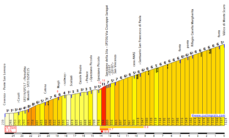
Monte Amiata – 14,1km, 7,4% (max 16%), cat. 1, 1591m
Poggio dell'Ermicciolo – 2,9km, 8,2% (max 14%), cat. 3, 1115m
Poggio Piano – 5,3km, 6,1% (max 15%), cat. 3, 675m
Chianciano Terme – 7,2km, 2,7%, cat. 4, 466m

Sprints:
Manciano – 8km, 3,8%, 400m
Pienza – 3,8km, 5,1%, 488m

Sterrato:
Santa Fiora – 1,2km (partly hormigón)
Pienza – 5km
Monticchiello – 6km
San Savino – 7,8km

I'm okay with puting TTs after a rest day, but i'm more a fan of tricky stages myself. Because of lack of good sprint placement in the stage i decided to use some smaller climbs as sprints.

The stage starts in Porto Santo Stefano in very picturesque Monte Argentario peninsula – a former island merged with the mainland by two "tomboli" – stretches of sand and also a bridge from Orbetello. In the past the peninsula was the Caravaggio's resting place and Dutch royal family's summer residence. The two main towns on the peninsula are smaller Porto Ercole and bigger Porto Santo Stefano.

Argentario_dal_satellite.jpg

Satelite image of Monte Argentario.

Forte_Stella_Porto_Ercole_%28GR%29.jpg

Forte Stella.

1024px-P.S.Stefano_panorama.jpg

Porto Santo Stefano.

From Monte Argentario the stage goes inland via the north tombolo and then Albinia, Manciano (1st sprint), Pitigliano – a lesser known Tuscany gem and an ancient Etruscan town on top of a rock, and Sorano – another lesser known, rock-top gem before reaching the first climb of the day – Poggio Montone. I really recommend Pitigliano and Sorano, as they're beautiful.

lmKSPyu.jpg

Pitigliano.

Sorano.JPG

Sorano.

Just 10km from Poggio Montone starts the well known Monte Amiata. This time it's not an MTF; the top is 82km from the finish line. However, this climb with a long descent interrupted by short, but steep Poggio dell'Ermicciolo separates the first, medium mountain part of the stage from the Strade Bianche part.

I'm not sure if it's the hardest side of Amiata, or is the Castel del Piano side slightly harder. The climb to Amiata is complicated. First 1,2km to Santa Fiora are on a sterrato/hormigón murito. Hormigón is a rare occurence in Italy. This murito is at roughly 14%. Next 5km to Bagnolo are easier but the next 4,6km on Via della Vietta are at roughly 9% (includes a 2km at 10% and max around 16%). The last 3,5km are slightly easier. Overall, it's 14,1km at 7,4%, which is a borderline TdF HC.

5Z8j0vw.png

Monte Amiata.

The descent from Amiata ends near Castiglione d'Orcia, 36km from the top. The last 45km to the finish are closer to Strade Bianche with short, but steep muritos and almost 20km of sterrato. The hardest climb of this part – Poggio Piano, has a short, 1,2km at 10,2% section to Monticchiello.

xPd2Ym0.png

Poggio Piano.

pienza_vista_ovest.jpg

Pienza.

Last time i've did a Giro sterrato stage it was a relatively normal venture. This time i decided to shake it up a bit by focusing more on dirt descents. Hence, both Monticchiello and San Savino sectors have more downhill than uphill with even some occasional serpentines thrown in. It means the stage should be mainly for good bike handlers and considering Monte Amiata previously, the peloton could be quite small and many tougher gregarios could be lagging behind. A guy like Nibali or Thomas should try to use this stage to his advantage. Vino would probably orgasm to this stage.

q2YvHTq.jpg

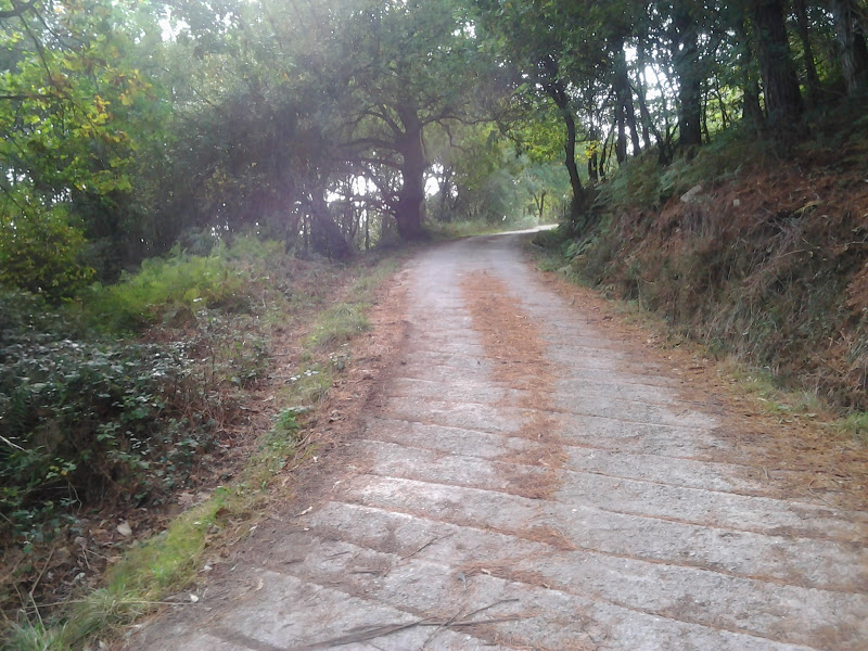
Monticchiello sector.

VOqgh2W.jpg

San Savino sector.

The finish line is in Chianciano Terme, just after the San Savino sector. It's an uphill finish with 7,2km at 2,7%, but it does include the last flat 2km to the Terme part of Chianciano. The toughest are the middle 2km at 5,5% to the historical centre. The last 350m long straight is at roughly 7%. The finish line is on Viale Roma, in front of Grand Hotel.

VEvqhsA.png

Profile of Chianciano Terme.

xZyVpjo.jpg

Finish in Chianciano Terme.

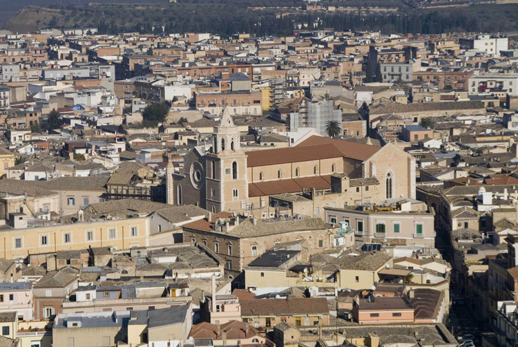
Chianciano Terme is an ancient spa, as even Etruscans used the Silene springs for healing reasons. It also was a popular terme in ancient Rome. In the middle ages it was an important trade centre on Via Francigena (medieval Italy-France road). The modern terme was finished in 1960's.

aUx45mE.jpg

Historical centre of Chianciano Terme.

ePADmUQ.jpg

Terme part of Chianciano Terme.

What to expect from this stage? Change sterrato for nordic cobbles and it would be interesing ;). It should be a fine test for tougher guys, who can resist Monte Amiata or more versalite GC guys like Nibali or lately GT. I'm not entirely sure about the possible outcome of this stage, as i don't remember seeing anything remotely similar in real life to this stage. Hope, that the more technical, descent oriented sterrato sections will provide okay racing even in the driest weather possible.
 
Re:

Forever The Best said:
Great stage and very similar to this:
viewtopic.php?p=2124151#p2124151
:D :cool:
I expected, there were plenty of these. Saldy, at the time you were doing your Giro v1 i was more focused on work and Vuelta. Still, i guess there are plenty of similar stages with Amiata and i need to admit... i would love to see such concept in real life, hence i decided to include it in my Giro. I also have some unfinished business with more popular climbs in the Alps, so there will be 2 stages using popular climbs. If you'll check my profile, you'll see, that i have some TdF leftovers and a couple of stages in Switzerland. Not sure, on which one i will focus.
 
Re: Re:

railxmig said:
Forever The Best said:
Great stage and very similar to this:
viewtopic.php?p=2124151#p2124151
:D :cool:
I expected, there were plenty of these. Saldy, at the time you were doing your Giro v1 i was more focused on work and Vuelta. Still, i guess there are plenty of similar stages with Amiata and i need to admit... i would love to see such concept in real life, hence i decided to include it in my Giro. I also have some unfinished business with more popular climbs in the Alps, so there will be 2 stages using popular climbs. If you'll check my profile, you'll see, that i have some TdF leftovers and a couple of stages in Switzerland. Not sure, on which one i will focus.
Ah, I wasn't criticizing, just saying that that type of stages are great. And the bolded is the reason why I included it in my Giro as well.
 
Previous stage: link

Giro d'Italia – stage 11. Montepulciano – San Miniato, 155km, hilly, HTF.
https://www.la-flamme-rouge.eu/maps/viewtrack/hd/151398
sqI1pP1.jpg

OLaNx4h.png


Climbs:
San Pancrazio – 5,2km, 3,4%, cat. 4, 471m
Monte Centramura – 13,2km, 4%, cat. 3, 692m
San Miniato – 1,5km, 7,5% (max 14%), cat. 4, 143m

Of course i don't think Montepulciano really needs any introduction as it's the 2nd most popular murito centre after Todi.

Montalcino-panoramica.jpg

Montepulciano.

The whole stage loosely covers Via Francigena – the medieval main route between France and Italy. The first 65km of the stage takes place in eastern Tuscany near Arezzo, alongise the Arno valley before a transfer through Chianti (Monte Centramura, Radda in Chianti) to the final 40km in Elsa valley.

9_CC_Bernd_Thaller.jpg

Certaldo.

Kn7tIPC.jpg

Radda in Chianti.

The main feature of this stage is the last 1,5km at 7,5% uphill dash to San Miniato. It does feature tougher sections up to over 10% (even roughly 14%). The side i've chosen (there are plenty of them) is SP7 from San Miniato Basso. The finish line is on Piazza Dante under the city walls. I wanted a finish in San Miniato since i was doing my first Giro. Back then i decided for Viareggio, because San Miniato was just too close to San Gimignano.

XLWvyRm.png

Profile of San Miniato.

Sl4HwO7.jpg

One of the hardest sections of San Miniato.

Because of the location on Via Francigena and an intersection between Florence-Pisa and Lucca-Siena it was the Tuscany's trade and administrative centre. In XIV c. the town was in the centre of Siena-Florence wars.

1QE0f2z.jpg

San Miniato.

Next stage starts in Peschia, near Collodi (Pinocchio) and Montecatini Terme.

Giro d'Italia – stage 12. Pescia – Schia. Monte Caio, 189km, medium mountain, MTF.
https://www.la-flamme-rouge.eu/maps/viewtrack/hd/151505
SuiGp1n.jpg

CxVCyNx.png


Climbs:
Passo dei Carpinelli – 6,4km, 4%, cat. 4, 842m
Passo del Cerreto – 20km, 5%, cat. 2, 1257m
Schia (Pian della Giara) – 9km, 8% (max 16-18%), cat. 1, 1266m

AMXK519.jpg

Garzoni Garden, Collodi.

It's more of a fake MTF, but otherwise this Giro would have none of them. There's no lazy Pradaccio – Abetone/whatever stage because i just didn't wanted it. I also rejected Passo dei Due Santi/Zum Zeri as it was also used plenty of times. There are however many other, kinda neglected places in Appennino Tosco-Emiliano.

Last time i've used the Sassostorno side of Piane di Mocogno. If you want a harder Abetone, you can use Doganaccia 2000 near Passo della Croce Arcana, which is part of Abetone Ski. There's also a murito finish on Riff. le Polle, on the other side of Monte Cimone, which should work well with Pradaccio. I've decided to use the westernmost part of Appennino Tosco-Emiliano – Garfagnana region, where the Appennino Tosco-Emiliano National Park is located.

The main chunk of the stage takes place in the Serchio valley, before crossing Garfagnana and entering Emilia-Romagna on Passo del Cerreto (one of the many cols in the area). The last part takes on the northern slopes of Garfagnana. Finish is in Schia - a small ski station on the slopes of Monte Caio (1575m).

CarpinelliE.gif

Passo dei Carpinelli.

CerretoS.gif

Passo del Cerreto.

I've decided for Cerreto rather than the slightly harder Passo di Pradarena, because Cerreto has better views (it's not as forested) and because it's mid-stage, way before the MTF, so it doesn't need to be the hardest thing ever. As a leg-warmer it should do the job as well as Pradarena would and i feel Pradarena is created for bigger ideas. Cerreto is also home to nearby small ski station Cerreto Laghi.

garfagnana-001-2.jpg

Garfagnana.

ParcoNazionaledell'AppenninoToscoEmiliano_DavideFerrari_02.jpg

Parco Nazionale dell'Appennino Tosco Emiliano.

There are plenty of ways to reach Schia. The main one is an okay climb from Groppizioso (similar to Verbier). The eastern way using Via Casavalgana from Capriglio is slightly harder. I've decided for probably the hardest, western side via Pian della Giara combined with a small murito (SP14) to Tizzano Val Parma. Overall, it's 9km at 8%, a borderline cat. 1 and a strong TdF cat. 1. Because of irregularity i've decided for cat. 1.

5K8R6BD.png

Pian della Giara.

The climb is separated into 3 sections. First one if a murito to Tizzano Val Parma, which is 2,5km at 10% with sections of almost 20%. Next 2km to Musiara Inferiore are easier. The last roughly 5km are at 8,5% with another ~15% section near the top.

vOe5p83.jpg

Murito to Tizzano Val Parma.

ijFxkYv.jpg

Views from the top of Pian della Giara, Po valley in the background.

The last 2,7km from the top are at first downhill (quite steep and technical) and then uphill. The last 1,5km to the ski station are on a slight uphill (up to 5%). The finish line is on Piazza Neobocchi.

vek0jgv.jpg

A serpentine on a descent from Pian della Giara.

I guess Pian della Giara can be more selective than it looks on paper, and the time splits be a bit bigger than usually thank to the last, technical 2,7km. I guess the main selection will take place on the first murito, while attacks on over 10% sections near the top. It's definitely a tricky stage, which should not be underestimated. Of course Schia is not as hard as many other climbs in the region, but for me it's a much more interesting find than anything around Monte Cimone.

cimkqQ6.jpg

Schia.

Next stage is one of the last sprints across the Po valley followed by a very tough weekend in the Alps.