Race Design Thread

Page 339 - Get up to date with the latest news, scores & standings from the Cycling News Community.
Yea, they posted that they're up and running but without any of the old pass data, login details or routes. Which is a real shame for me as I had a large backlog of stuff, so like Samu I will hold off temporarily in the hope that they are able to retrieve at least SOME of the logins etc., but I think it's an inevitability that it's lost. It's ok, they've done great to get back online but it's obviously a limited version atm.

LCC, are you able to confirm whether you can use the old version of the editor if you're logged in, because that sends you to the login screen if you click it on the editor when not logged in.
 
@Mayomaniac, given that it's your training grounds, I assume you have ridden up the small road through Percha/Perca on the way to Tesselberg near Bruneck/Brunico. Is it really 1 km at ~15 %?

And while I have you, how is the road for Onach/Onies? On Street View it's partly unpaved (June 2022).
 
@Mayomaniac, given that it's your training grounds, I assume you have ridden up the small road through Percha/Perca on the way to Tesselberg near Bruneck/Brunico. Is it really 1 km at ~15 %?

And while I have you, how is the road for Onach/Onies? On Street View it's partly unpaved (June 2022).
The road to Onach got fixed, but usually I climb the Würzjoch from that side instead because it's right after the Furcia and you avoid riding in the valley with all the traffic until St. martin.

Nah, maybe 1km at 11%, but I usually ride more around Cortina, behind the Kreuzbergpass and on the steep climbs around Lienz.

In the Pustertal you have to avoid the main road and use Bikepaths/secondary roads up on the mountains because the traffic gets that bad when lots of Tourists are around.

The other side of Tesselberg (the one used on the final stage of the Tota) is legit 5km at 12% with 16% ramps.

In that area Nevesstausee is another nasty climb, the steep part near the end is a lot like Peña Cabarga with ramps up to 19%.
 
Sep 22, 2020
106
119
3,030
The road to Onach got fixed, but usually I climb the Würzjoch from that side instead because it's right after the Furcia and you avoid riding in the valley with all the traffic until St. martin.

Do you think it would be possible for a Giro to descend the Würzjoch via Luson/Lüsen? I had planned a stage finish at Maranza via the Würzjoch followed by Alpe di Rodegno via the Lüsner Alm. I ask because when I last looked on street view it appeared that there were some wooden bridges and I don't know if they would be suitable for a race to go over.
 
Do you think it would be possible for a Giro to descend the Würzjoch via Luson/Lüsen? I had planned a stage finish at Maranza via the Würzjoch followed by Alpe di Rodegno via the Lüsner Alm. I ask because when I last looked on street view it appeared that there were some wooden bridges and I don't know if they would be suitable for a race to go over.
Probably doable in a race. Frankly it's probably safer in a race than normally, because you don't have to worry about a car coming the other way on a rather narrow road behind every corner.
Descending towards Lüsen from the Rodenecker Alm would be borderline, the way you want to go is totally fine.
 
  • Like
Reactions: Fyr3
Euskal Herriko Itzulia

22px-Plainstage.svg.png
1. etapa: Huarte > Saint-Jean-Pied-de-Port (170 km)
22px-Hillystage.svg.png
2. etapa: Saint-Jean-Pied-de-Port > Combo-les-Bains (162 km)
22px-Mediummountainstage.svg.png
3. etapa: Saint-Jean-de-Luz > Durango (Urkiola) (155 km)
22px-Mediummountainstage.svg.png
4. etapa: Eibar > Eibar (136 km)
22px-Hillystage.svg.png
5. etapa: Bilbao > Bilbao (150 km)
22px-Time_Trial.svg.png
6. etapa: Bilbao > Bilbao (CRI) (35 km)

Overall map, stage details and descriptions, final edits, and overall summery and motivation to follow.
 
  • Like
Reactions: OlavEH
Monster stage to Bilbao. I was kind of all "surprisingly light SJPdP stage, Netserk?!" but it makes sense in context. I think in a real version of this race the run-in in the Cambo-les-Bains stage would be a lot flatter just to not make the race a fully roided-out version of a typical Itzulia, but then 35km of ITT at least is justified here.

Also I certainly support the use of the hormigón side of Usartza AND the Krabelin side of Arrate in the same stage.
 
I would rather water down the Bilbao stage instead of the one to Cambo-les-Bains. The finale of the latter was what spurred me on to draw up the rest of the race.

It's like the 2019 Vuelta stage, but with additional hills and a loop in the end. With the ITT the next day, I think the GC riders would be inclined to wait for the last climb, and maybe even race that one passively.

I thought you would comment on Azurtzamendi, like you did a decade ago here.
 
Last edited:
I would rather water down the Bilbao stage instead of the one to Cambo-les-Bains. The finale of the latter was what spurred me on to draw up the rest of the race.

It's like the 2019 Vuelta stage, but with additional hills and a loop in the end. With the ITT the next day, I think the GC riders would be inclined to wait for the last climb, and maybe even race that one passively.

I thought you would comment on Azurtzamendi, like you did a decade ago here.
The flip side is that maybe they would go with the stage as designed from Espelette onwards, but given its position in the race and that stage 3 is the MTF, it would perhaps be after a more or less flat (you know, as much as País Vasco allows) first half of the stage in that case. I'm guessing that for the most part the likes of Izpegui there are only going to serve as leg-softeners, though, as all the action would be in that last 30km or so.
 
I don't lose anything important if I skip Otxondo and Lizarrieta by going through Elizondo on the way to Bera, but it would leave the first half of the stage very anaemic. The next stage to Urkiola is already very easy until the finale, so I'll have to go over the past editions once more to judge whether or not it makes the race too hard.
 
I don't lose anything important if I skip Otxondo and Lizarrieta by going through Elizondo on the way to Bera, but it would leave the first half of the stage very anaemic. The next stage to Urkiola is already very easy until the finale, so I'll have to go over the past editions once more to judge whether or not it makes the race too hard.
Oh, it doesn't make the race too hard for me, but for Adam Hansen?
 
Frankly that stage still works fine without it, just add in the climb to Latzfons via Feldthurns at the start instead and it's still great. Würzjoch/Jö de Börz from that side is a really underrated, great climb.
That said, I looked at it again and there's maybe one really sketchy corner, IMO you can still use it. That side of the climb that you are using, 7.5km at 11% is something I've mainly experimented with when thinking about stage finishes at the ski station in Vals afterwards (and Würzjoch via Longega/Zwischenwasser before, I love that climb as much as I hate Furcia from the Olang side (irregular climb and really exposed to the sun). That said, Rodenecker Alm from Mühlbach is also nice, 11km at 9% is a good climb and the last time I did it the heat was brutal (38°C down in Brixen)
 
I'd like to give all you creative people a little challenge.

This was posted over in the General News thread:

I don’t know where to put this, but found what ChatGPT’s hypothetical Tour route to be funny
View: https://mobile.twitter.com/AndyGraham22/status/1645438484398632963

Two Mount Ventoux MTF’s would be interesting.

However, as you can see it's only start, finish, and length. As well as, in a few cases, key points. The actual routes are not detailed.
Well, what do you guys come up with?
 
I'd like to give all you creative people a little challenge.

This was posted over in the General News thread:


However, as you can see it's only start, finish, and length. As well as, in a few cases, key points. The actual routes are not detailed.
Well, what do you guys come up with?
I think most of the stage lengths are actually impossible as the supposed stage hosts are too far apart, so we would need to come up with some rules if we want to turn this into a proper challenge.

I would stick to the race distances instead of the start towns whilst keeping the finish locations intact to keep the already too long race distance in check, but you would want to limit the distance between ChatGPT‘s starting town and the newfound stage hosts.
 
  • Like
Reactions: RedheadDane
Regarding the proposed Tour route:
I quite like stage 13, from Dijon to Besancon. I'm sure you could make a good stage between the two towns; Google Maps says around 110ish KM, but you could of course make it longer by just not taking the direct route.
But, no! Gotta be 45 KM ITT. Figure it out!
 
It's the year 2030: ASO has been sold to the Saudis and just like the race formerly known as Paris-Dakar the Tour has been relocated to Arabia.

Nah, I'm just messing with you. Now that I've (hopefully) managed to grab your attention with my dystopian vision, let's talk more about potential races in Arabia (yeah, I'm not gonna talk about the obvious elefant in the room, because forum rules). The amount of absurdly hard, steep climbs that you find there is absurd. Now what's something that could grab the interest of some of the rich investors over there? How about a one day race for climbers with the hardest climb in the world (that gets used in an actual races)? Have it at the start or the end of the season with lots of price money and nice starting fees for top climbers/gc riders.
With the initial premise explained, let's get to the race:

Azir Mountains climbers challenge; 181km
DtH6UsX.png

lPQY3C8.png


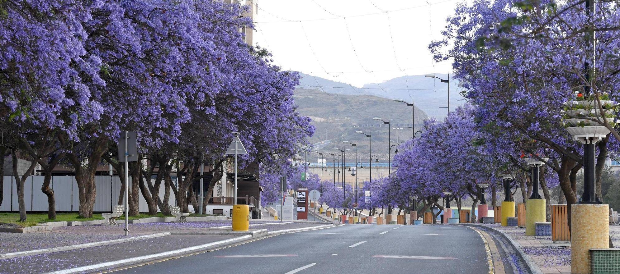
The race starts in Abha, the capital of the Azir region with over 200,000 inhabitants.
Abha:
abu-khayyal-garden.jpg


One of the main roads during the jacaranda tree blossom.
1559971.jpg

The short little uphill raise that you see top after 4.3kms is the short uphill drag up to Abu Kheyal Park, 500m at 7.6%. The main breakaway should form a bit later on the climb up to Al Soudah, that I've split into 2 different categorised climbs because of the false flat in the middle.
The first one is the climb to Eastern Point View (a viewpoint to watch over the city), 4.6km at 5.5%. Then, after 9kms of uphillish false flat, the 2nd climb starts, the actual drag up to Al Soudah proper, 3.3km at 4.9%.
Afterwards you have 47kms of slightly downhillish false flat, then the actual descent towards Muhayil starts. The steep part is 10kms at 6.5%, followed by 46kms at around 2% flase flat downhill until we reach the lowest point of the race near Muhayil.
Now the road starts going up again. Firstly it's a gentle 2% uphill drag for 18.5kms, followed by 4kms at 4.7%.
Now this is where the fun begins, now the real monster starts. 
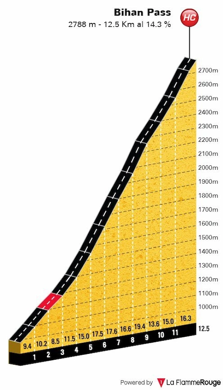
Al Jaadah Pass/Bihan Pass, 12.5kms at 14.3%
Bihan-Pass-Hardest-Cycling-Climbs-in-the-world.webp
FETAL-pVIAMpxd5

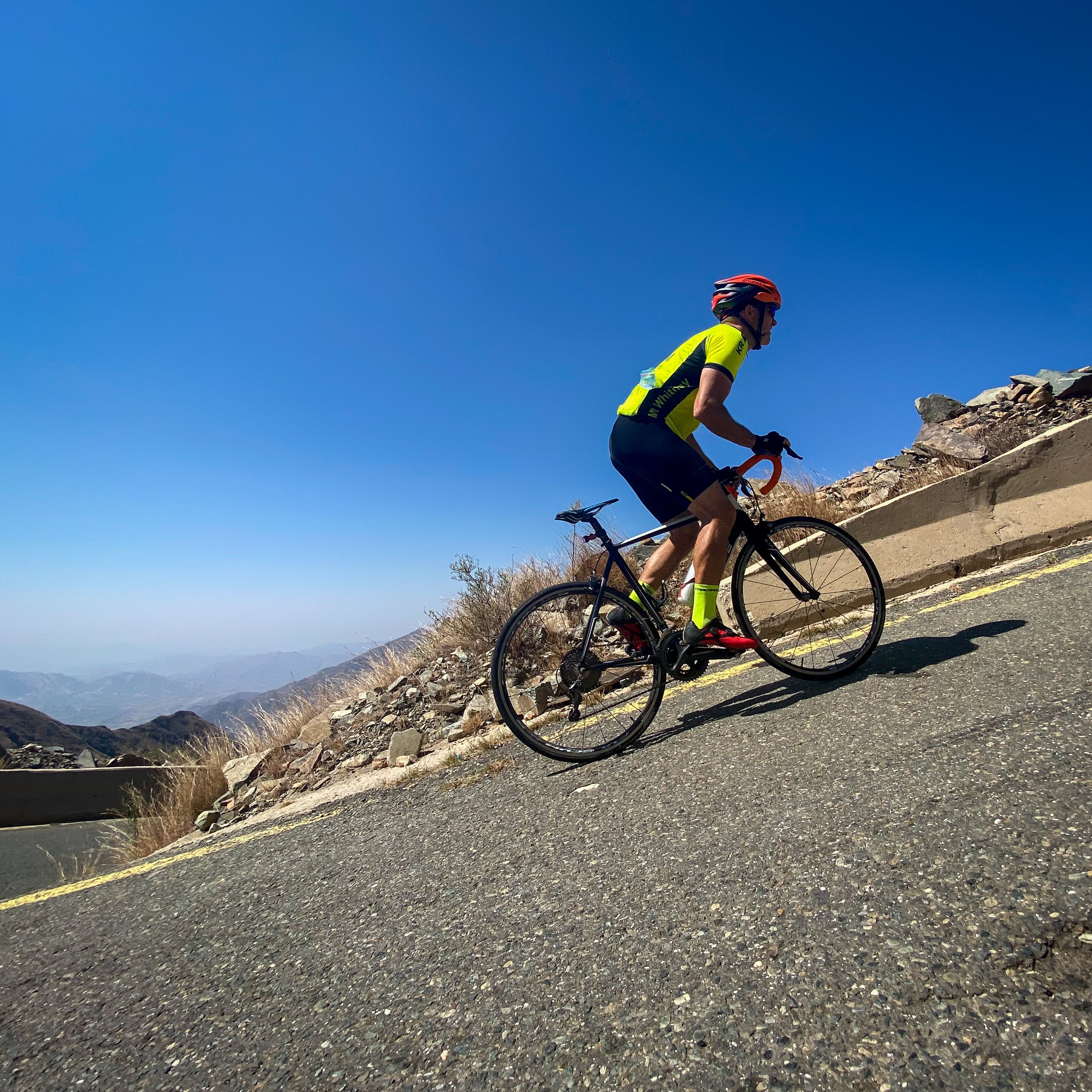
The guys at Pjammcycling have posted lots of footage of someone climbing this brute, this gives you an idea of how steep this one actually is and how surprisingly wide and nice the road is: https://pjammcycling.com/climb/3038.Al-Jaadah-Pass;mode=Photo;name=Main

It's pretty much 2.5 times as long as the steep part of the Zoncolan and at a similar height as the Stelvio, HC indeeed.

The climb tops with 19.3kms to go, that means that the race won't be finished on top of this monster. The rest of the race is characterized by short descents, rolling terrain and short climbs. 8.1kms later we have a short climb, 1.5kms at 5.5%, followed by around 1.7kms of false flat and a descend that is 4.2kms at 5.3%.

Then the final climb of the day starts, up to Assalam Park above Sabah. The actual climb is 2.5kms at 5.8%, the final 1.2kms of the race are flat and even slightly downhill in the end. I know, the race pretty much ends in the middle of nowhere, but the next slightly larger town is Al Haras and finishing there would mean adding 16km of rolling terrain in the end and I'm happy with the monster climb topping with a bit over 19kms to go.
 
Last edited: