
Race Design Thread
Page 28 - Get up to date with the latest news, scores & standings from the Cycling News Community.
You are using an out of date browser. It may not display this or other websites correctly.
You should upgrade or use an alternative browser.
You should upgrade or use an alternative browser.
- Jun 7, 2010
- 19,196
- 3,092
- 28,180
- Sep 8, 2010
- 1,441
- 0
- 0
Tour of Japan || Stage 9: Ono - Onogawa, 198 km

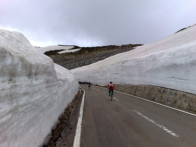
It's sunday. This means it is time for some serious climbing. Still it is not a super-heavy mountain stage, but it is hard enough to shake up the whole race. The stage starts from the small town Ōno and heads west towards Nagano. Two-thirds of the stage are mostly hilly, but without any severe climbs. But after that a true giant is waiting. The Norikura Skyline Road tops at 2720 meters after a long climb of nearly 30k. It is Japan's highest paved road, accessible for public. Then it is still 23k to go, before we reach the finish line. The first part of this descent will be very steep and technically demanding. So it might be possible to close a gap or of course cleary increase one.

Climbs
Cat. 3 // Route 158 (742m), 4,9k @ 3.4%.
Cat. 2 // Matsunoki Pass (1129m), 5k @ 4.0%.
Cat. HC // Norikura Skyline Road (2720m), 27k @ 7%
Ono

Norikura Skyline Road
It's sunday. This means it is time for some serious climbing. Still it is not a super-heavy mountain stage, but it is hard enough to shake up the whole race. The stage starts from the small town Ōno and heads west towards Nagano. Two-thirds of the stage are mostly hilly, but without any severe climbs. But after that a true giant is waiting. The Norikura Skyline Road tops at 2720 meters after a long climb of nearly 30k. It is Japan's highest paved road, accessible for public. Then it is still 23k to go, before we reach the finish line. The first part of this descent will be very steep and technically demanding. So it might be possible to close a gap or of course cleary increase one.
Climbs
Cat. 3 // Route 158 (742m), 4,9k @ 3.4%.
Cat. 2 // Matsunoki Pass (1129m), 5k @ 4.0%.
Cat. HC // Norikura Skyline Road (2720m), 27k @ 7%
Ono
Norikura Skyline Road
- Feb 20, 2010
- 33,267
- 15,816
- 28,180
I demand a Cima Coppi-esque prize for the ceiling of the race like the Giro and Vuelta, mainly on the basis that that climb looks awesome.
- Feb 20, 2010
- 33,267
- 15,816
- 28,180
As we head into the penultimate weekend, the weekdays end with a bit of respite for the riders...
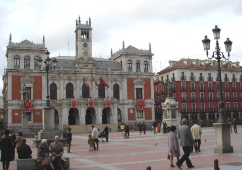
Stage 13: Valladolid - Astorga, 170km

This is as flat as it comes, traversing the plains of Castilla y León between the historic city of Valladolid, and the smaller town of Astorga, home of Santo Toribio, where the riders will finish outside the imposing and historic Episcopal Palace, designed by the infamous Gaudi. The sprinters will be glad to have a chance to have a say and, given that this is the Vuelta, this may well be the last thing they stick around for. There isn't really a great deal that can be said about this; there is the possibility of wind, as the stage will be very, very exposed, but if the gusts aren't blowing in the right direction, this will be a routine bunch sprint, and everybody except some foolhardy Andalucía-Caja Granada rider will enjoy a relatively benign day ahead of the tests to come. Not a single categorised climb to mar the sprinters' perfect day on the plains.

Valladolid:
Astorga:

Stage 13: Valladolid - Astorga, 170km
This is as flat as it comes, traversing the plains of Castilla y León between the historic city of Valladolid, and the smaller town of Astorga, home of Santo Toribio, where the riders will finish outside the imposing and historic Episcopal Palace, designed by the infamous Gaudi. The sprinters will be glad to have a chance to have a say and, given that this is the Vuelta, this may well be the last thing they stick around for. There isn't really a great deal that can be said about this; there is the possibility of wind, as the stage will be very, very exposed, but if the gusts aren't blowing in the right direction, this will be a routine bunch sprint, and everybody except some foolhardy Andalucía-Caja Granada rider will enjoy a relatively benign day ahead of the tests to come. Not a single categorised climb to mar the sprinters' perfect day on the plains.
Valladolid:
Astorga:
- May 6, 2009
- 8,522
- 1
- 0
Of the Asian countries I've visited, Japan looks the safest to ride in, at least they ride on the same side of the road as I do. Cycling in the major cities of Vietnam is fine if you have a death wish (even crossing the road is dodgy), China isn't too bad, but is quite chaotic. I would love to ride the Norikura Skyline Road.
- Feb 20, 2010
- 33,267
- 15,816
- 28,180
It's time for what is probably the queen stage of my Vuelta, and certainly the longest one at least.
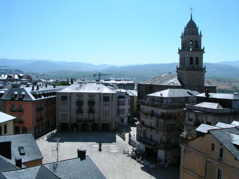
Stage 14: Ponferrada - Oviedo (Monte Naranco), 242km

The city of Ponferrada is part of Spanish cycling's history, hosting many a race either within the city or in the hills and mountains surrounding it (the Alto del Morredero of course being its most typical summit finish), and of course it is hosting the 2014 World championships. As a result it would be kind of wrong not to involve it in the Vuelta, but there will be little time for them to show off their worlds parcours in a stage like this.
This is an unusual queen stage, in that there is a summit finish, and yet the stage finishes at a lower altitude than it started; however the route by which they get there is one which will be paved with lots and lots of pain. No fewer than seven categorised climbs in today's stage, of which three are category 1. The first, after a benign, flat first 65km, is the slow and gradual drag up to the Castilian side of the Puerto de Somiedo. No real threats here. However, this is followed almost immediately by La Farrapona, which was of course a summit finish in the 2011 race. From here the riders tackle the last few kilometres of the Castilian side of the Puerto de la Ventana, before the descent back down to Taverga.
From here we have some rolling, uncategorised up-and-down before we reach the base of the Alto de la Cobertoria. After 169km which hasn't exactly been easy, the riders now face an action-packed final 73km, which will test their mettle, strength and their guts. First, there is the Alto de la Cobertoria, a fabled Vuelta climb. Averaging over 8%, there is plenty of scope to thin the bunch down to the absolute essentials here. And as soon as we get to the bottom of the similarly steep descent, we arrive at the base of the Alto del Cordal. Though this climb isn't long, it is steep, inconsistent and rated first category as it has been in the Vuelta in recent years. Now, naturally, normally this serves as a lead-in to the Anglirú, but we're not being that predictable. After all, the Anglirú is a vicious, savage beast that riders will leave everything for. Instead, we will climb the new climb of the Alto de la Vara; this is not as steep a climb, but the final 3km are at 8%; after this there is a short wall and 6 flat kilometres through Oviedo before placing the riders at the foot of the final obstacle of the day; Monte Naranco.
Though Monte Naranco is well-known and beloved in the Asturian cycling scene, it is simply not difficult enough to create large gaps on its own; the climbers should have lost their time in the long ITT into Córdoba. The best platforms for attack in this stage are Cobertoria - which crests 64km from home - and Cordal - which crests 46km from home. In the favour of attacking is that there are practically no flat kilometres in the second half of this stage and especially not in this manic final 70km. It is too late to leave it to Naranco, but Naranco could equally be enough to break the long-range attackers; similarly, a diesel climber may struggle to maintain the tempos of the climbers on the steep and inconsistent climbs earlier on, and simply be broken by attrition by the time we get to Oviedo, whereupon Naranco could create gaps far more extreme than its meagre difficulty would imply. Certainly this one might be a hell for the autobus - could be over seven and a half hours in the saddle for any unfortunate enough to be dropped on Farrapona.
The riders will probably be praying for a cool, clear day; because late summer in Spain is known for extreme heat, and the Asturias region is known for severe rain. Either one will turn this into a manic, brutal slaughter of a stage.

Climbs:
Puerto de Somiedo (cat.3) 9,0km @ 2,7%
La Farrapona (cat.1) 18,7km @ 5,8%
Puerto de la Ventana (cat.3) 6,0km @ 4,2%
Alto de la Cobertoria (cat.1) 8,1km @ 8,5%
Alto del Cordal (cat.1) 5,7km @ 8,9%
Alto de la Vara (cat.2) 6,9km @ 5,6%
Monte Naranco (MTF) 6,8km @ 5,8%
There may not be the monolithic passes here in this region of Spain, and I may only be having the one true Asturian mountain stage, so I figured I'd better make it worth it.
Ponferrada:
Monte Naranco:

Stage 14: Ponferrada - Oviedo (Monte Naranco), 242km
The city of Ponferrada is part of Spanish cycling's history, hosting many a race either within the city or in the hills and mountains surrounding it (the Alto del Morredero of course being its most typical summit finish), and of course it is hosting the 2014 World championships. As a result it would be kind of wrong not to involve it in the Vuelta, but there will be little time for them to show off their worlds parcours in a stage like this.
This is an unusual queen stage, in that there is a summit finish, and yet the stage finishes at a lower altitude than it started; however the route by which they get there is one which will be paved with lots and lots of pain. No fewer than seven categorised climbs in today's stage, of which three are category 1. The first, after a benign, flat first 65km, is the slow and gradual drag up to the Castilian side of the Puerto de Somiedo. No real threats here. However, this is followed almost immediately by La Farrapona, which was of course a summit finish in the 2011 race. From here the riders tackle the last few kilometres of the Castilian side of the Puerto de la Ventana, before the descent back down to Taverga.
From here we have some rolling, uncategorised up-and-down before we reach the base of the Alto de la Cobertoria. After 169km which hasn't exactly been easy, the riders now face an action-packed final 73km, which will test their mettle, strength and their guts. First, there is the Alto de la Cobertoria, a fabled Vuelta climb. Averaging over 8%, there is plenty of scope to thin the bunch down to the absolute essentials here. And as soon as we get to the bottom of the similarly steep descent, we arrive at the base of the Alto del Cordal. Though this climb isn't long, it is steep, inconsistent and rated first category as it has been in the Vuelta in recent years. Now, naturally, normally this serves as a lead-in to the Anglirú, but we're not being that predictable. After all, the Anglirú is a vicious, savage beast that riders will leave everything for. Instead, we will climb the new climb of the Alto de la Vara; this is not as steep a climb, but the final 3km are at 8%; after this there is a short wall and 6 flat kilometres through Oviedo before placing the riders at the foot of the final obstacle of the day; Monte Naranco.
Though Monte Naranco is well-known and beloved in the Asturian cycling scene, it is simply not difficult enough to create large gaps on its own; the climbers should have lost their time in the long ITT into Córdoba. The best platforms for attack in this stage are Cobertoria - which crests 64km from home - and Cordal - which crests 46km from home. In the favour of attacking is that there are practically no flat kilometres in the second half of this stage and especially not in this manic final 70km. It is too late to leave it to Naranco, but Naranco could equally be enough to break the long-range attackers; similarly, a diesel climber may struggle to maintain the tempos of the climbers on the steep and inconsistent climbs earlier on, and simply be broken by attrition by the time we get to Oviedo, whereupon Naranco could create gaps far more extreme than its meagre difficulty would imply. Certainly this one might be a hell for the autobus - could be over seven and a half hours in the saddle for any unfortunate enough to be dropped on Farrapona.
The riders will probably be praying for a cool, clear day; because late summer in Spain is known for extreme heat, and the Asturias region is known for severe rain. Either one will turn this into a manic, brutal slaughter of a stage.
Climbs:
Puerto de Somiedo (cat.3) 9,0km @ 2,7%
La Farrapona (cat.1) 18,7km @ 5,8%
Puerto de la Ventana (cat.3) 6,0km @ 4,2%
Alto de la Cobertoria (cat.1) 8,1km @ 8,5%
Alto del Cordal (cat.1) 5,7km @ 8,9%
Alto de la Vara (cat.2) 6,9km @ 5,6%
Monte Naranco (MTF) 6,8km @ 5,8%
There may not be the monolithic passes here in this region of Spain, and I may only be having the one true Asturian mountain stage, so I figured I'd better make it worth it.
Ponferrada:
Monte Naranco:
- May 6, 2009
- 8,522
- 1
- 0
Netserk said:Dollerup Hills
This is a circuit only a few km from my house. I ride it myself, mostly because of the view around the lake
The whole circuit van be viewed in Google street view. As a race I would prefer it to be at autumn, so there also will be some wind. 18 rounds around gives the race a total distance of 261 km.
That would be great for the Tour of Denmark.
- May 6, 2009
- 8,522
- 1
- 0
Tour of Algeria stage 7 - Ain Temouchent - Tiemcen - 177.5km:
Map and profile
Stage 7 starts from the Citè les Logements in Ain Temouchent, it's not an easy ride to the uphill finish to Tiemcen with barely a metre of flat in the whole 177.5km. The gradient isn't the hardest, but with a lot of climbing and a high pace being set should result in some time gaps if any riders are not feeling strong. It's a stage for a breakaway.
- Sep 8, 2010
- 1,441
- 0
- 0
Tour of Japan || Stage 10: Okaya - Toyama, 188 km

After a rest day, we put the GC to a rest for three days. Three days for sprinters, attackers and puncheurs. So this stage can be divided into two parts. In the first section, where the race leaves the Nagano region, the peloton faces some climbing and one Cat.1 climb. This can create groups or bring sprinters into bigger problems. It depends of course on how it is done. The second part is completely flat. Peloton will chase, but you never know after ten stages.

Climbs
Cat. 4 // Shiojiri Pass (1001m), 3,8k @ 3.6%.
Cat. 3 // Nagawado Dam (1097m), 9k @ 3.5%.
Cat. 1 // Ice Bow Gate (1790m), 12k @ 6%
Okaya

Toyama
After a rest day, we put the GC to a rest for three days. Three days for sprinters, attackers and puncheurs. So this stage can be divided into two parts. In the first section, where the race leaves the Nagano region, the peloton faces some climbing and one Cat.1 climb. This can create groups or bring sprinters into bigger problems. It depends of course on how it is done. The second part is completely flat. Peloton will chase, but you never know after ten stages.
Climbs
Cat. 4 // Shiojiri Pass (1001m), 3,8k @ 3.6%.
Cat. 3 // Nagawado Dam (1097m), 9k @ 3.5%.
Cat. 1 // Ice Bow Gate (1790m), 12k @ 6%
Okaya
Toyama
- Feb 20, 2010
- 33,267
- 15,816
- 28,180
Following on from the queen stage, we have a short mountain stage in completely different style now.
Stage 15: Llanes - Alto Campoo (Fuente del Chivo), 140km

Moving across Asturias and then spending the bulk of the stage in Cantabria, this stage has been designed to be short and relatively simple so as not to discourage attacking on the previous stage; this is not a brutal climbing stage, but the way the majority of the second half is at a continual uphill drag means that selections could well be forced by attrition, just as on a stage like 2008's Fuentes de Invierno finish. With 240km+ of riding in their legs from the previous day, it is with a heavy heart that the riders will face the five categorised climbs of this stage. Luckily for them, the first 50km or so are more or less flat, and the next 40 go over two relatively unchallenging climbs. Of the last 50km, however, 40 are uphill. Now, much of this is at a relatively benign gradient - only the last 3-4km are really tough, with a maximum gradient of 16% being achieved 2km from home, as shown on the profile here. The selection on this stage is more likely to be forced by riders falling off the back than riders going off the front, so this is one for the GC men to set the likes of Szmyd and Niemiec on the front and try to burn off the opposition. Given that the second rest day follows this stage, you can definitely see some of the riders being intent on trying to force something on that short steep section near the end, and try to break the pace of those behind.

Climbs:
Alto de Gandarilla (cat.3) 4,5km @ 5,1%
Collado Ozalba (cat.2) 6,6km @ 5,3%
Collado Carmona (cat.2) 6,5km @ 5,4%
Alto Palomberas (cat.1) 22,0km @ 4,3%
Alto Campoo-Fuente del Chivo (cat.1) 21,3km @ 5,0%
Llanes:
Fuente del Chivo:

Stage 15: Llanes - Alto Campoo (Fuente del Chivo), 140km
Moving across Asturias and then spending the bulk of the stage in Cantabria, this stage has been designed to be short and relatively simple so as not to discourage attacking on the previous stage; this is not a brutal climbing stage, but the way the majority of the second half is at a continual uphill drag means that selections could well be forced by attrition, just as on a stage like 2008's Fuentes de Invierno finish. With 240km+ of riding in their legs from the previous day, it is with a heavy heart that the riders will face the five categorised climbs of this stage. Luckily for them, the first 50km or so are more or less flat, and the next 40 go over two relatively unchallenging climbs. Of the last 50km, however, 40 are uphill. Now, much of this is at a relatively benign gradient - only the last 3-4km are really tough, with a maximum gradient of 16% being achieved 2km from home, as shown on the profile here. The selection on this stage is more likely to be forced by riders falling off the back than riders going off the front, so this is one for the GC men to set the likes of Szmyd and Niemiec on the front and try to burn off the opposition. Given that the second rest day follows this stage, you can definitely see some of the riders being intent on trying to force something on that short steep section near the end, and try to break the pace of those behind.
Climbs:
Alto de Gandarilla (cat.3) 4,5km @ 5,1%
Collado Ozalba (cat.2) 6,6km @ 5,3%
Collado Carmona (cat.2) 6,5km @ 5,4%
Alto Palomberas (cat.1) 22,0km @ 4,3%
Alto Campoo-Fuente del Chivo (cat.1) 21,3km @ 5,0%
Llanes:
Fuente del Chivo:
- Feb 20, 2010
- 33,267
- 15,816
- 28,180
Coming out of the rest day, it's a stage for the Worlds warmup guys that are still here, and the puncheurs of this world.
Stage 16: Reinosa - Burgos, 151km

Starting from the base of the climb we finished on yesterday, this is a mostly pretty flat stage through northern Cantabria and through the Burgos region beloved of the Vuelta's main warmup extravaganza. There's only the one real notable climb in the day, where the race heads into a valley and back out the other side to continue its journey on the plains towards the city that has so frequently supported it.
Like the Vuelta's organisers, who are rumoured to have included it on the 2012 parcours, I was less keen on holding the typical city sprint that Burgos stages so often include, and instead opted for the short climb up to the Castillo that was used in this year's Vuelta a Burgos, as seen here.
Although Joaquím Rodríguez proved the victor that day, against a stronger, more eclectic field than that found in Burgos - very little reason for a sprinter or classics man to show up in the 2011 edition - this could be an interesting one; the climb is inconsistent, flattening out after the first section then getting steeper to a maximum of 14% before flattening out at the top; puncheurs and even strong classics men of the likes of Devolder could be able to contend this one (well, in Devolder's case maybe only a few years ago), as well as durable, versatile sprinters like Óscar Freire and José Joaquín Rojas, or riders such as Giovanni Visconti and Mauro Finetto. A further possibility is that the breakaway is allowed to go and swallow the bonus seconds, which will make for interesting battling in the closing stages amongst the break but a bit of a disappointment from the GC perspective.
The riders will pass the castle once before embarking on a final loop around the city and finishing on the second passage of the finishing line.

Climbs:
Puerto de la Mazorra (cat.2) 7,3km @ 5,4%
Burgos - Castillo de Burgos (no puntable) 1,3km @ 5,4%
Burgos - Castillo de Burgos (no puntable) 1,3km @ 5,4%
Reinosa:

Burgos (castle on left):

Stage 16: Reinosa - Burgos, 151km
Starting from the base of the climb we finished on yesterday, this is a mostly pretty flat stage through northern Cantabria and through the Burgos region beloved of the Vuelta's main warmup extravaganza. There's only the one real notable climb in the day, where the race heads into a valley and back out the other side to continue its journey on the plains towards the city that has so frequently supported it.
Like the Vuelta's organisers, who are rumoured to have included it on the 2012 parcours, I was less keen on holding the typical city sprint that Burgos stages so often include, and instead opted for the short climb up to the Castillo that was used in this year's Vuelta a Burgos, as seen here.
Although Joaquím Rodríguez proved the victor that day, against a stronger, more eclectic field than that found in Burgos - very little reason for a sprinter or classics man to show up in the 2011 edition - this could be an interesting one; the climb is inconsistent, flattening out after the first section then getting steeper to a maximum of 14% before flattening out at the top; puncheurs and even strong classics men of the likes of Devolder could be able to contend this one (well, in Devolder's case maybe only a few years ago), as well as durable, versatile sprinters like Óscar Freire and José Joaquín Rojas, or riders such as Giovanni Visconti and Mauro Finetto. A further possibility is that the breakaway is allowed to go and swallow the bonus seconds, which will make for interesting battling in the closing stages amongst the break but a bit of a disappointment from the GC perspective.
The riders will pass the castle once before embarking on a final loop around the city and finishing on the second passage of the finishing line.
Climbs:
Puerto de la Mazorra (cat.2) 7,3km @ 5,4%
Burgos - Castillo de Burgos (no puntable) 1,3km @ 5,4%
Burgos - Castillo de Burgos (no puntable) 1,3km @ 5,4%
Reinosa:
Burgos (castle on left):
- May 6, 2009
- 8,522
- 1
- 0
Time to finish off the Tour of Algeria.
Tour of Algeria stage 8 - Tiemcen - Chabaat El Leham - 198.5km:
Map and profile
A sprint finish today. Starting outside the Grand Bassin in Tiemcen, the peloton starts climbing straight away as they ride out of Tiemcen and through the Parc National de Tiemcen. It's not too hard and the peloton shouldn't split up too much, although there will be a plenty of attacks and if the riders legs are sore, they'll know about. After 136km, the peloton will travel through Sidi Bel Abbes, the home of the TT. There is some climbing in the last 10km, but it isn't much and should result in a sprint.
Tour of Algeria stage 9 - Ain Temouchent - Oran - 124km:
Map and profile
Stage 9 takes us from Ain Temouchent (another stage start for them) to the city of Oran. Ordinarily the direct route isn't that far distance wise, but they don't get it that easy. The town of Bou Tiels is the start of the first climb of the day at 42km, where the climb out of town is 4km at a max. gradient of 12.7%. The peloton is making their way closer to the Mediterranean Sea, although they stay inland a bit. As the peloton heads out of the small town of Bousfer, the next climnb is at 69km, and is 8km long with a max. gradient at 16.8% at the lower parts of the climb. This should cause a lot of carnage in the peloton and any GC favourites would need to be on their best form. At 85km, the peloton hits the outskirts of Oran and they continue to travel around Oran before the final 4km includes a 1km maxing out at 5.7% which should guarantee an attack or two. The finish is outside the Parc d'Attraction in Oran. A finish if it were to go down to a bunch sprint, the likes of EBH, Sagan, Goss, Hushovd would prevail.
- May 6, 2009
- 8,522
- 1
- 0
Tour of Algeria stage 10 - Tenes - Blida - 174.5km:
Map and profile
The last stage before the finish in Algiers. A tough ride to Blida who finally get a stage finish with barely a metre of flat for the first 120km as the peloton races along the Mediterranean from the stage start in Tenes, before turning inland at Cherchell. The peloton hits the town of Chiffa and a 7km climb to Blida although it isn't a hard climb in terms of gradient with a max. gradient of 5.9%, but this will result in a fast pace, before the descent into Blida before the false flat finish outside the Maison des Jeunes Benboulaid.
Tour of Algeria stage 11 - Algiers - Algiers circuit race -228km (19 laps at 13km):
Map and profile
The final day at the inaugural Tour of Algeria has come and like all good things, the race must come to an end. Finish in Algiers, the peloton will do a 19km, 13 lap circuit race which will give them 228km. Starting and finishing at the Rue Shakespeare, is a lumpy course which suit the likes of EBH, Hushovd, or Sagan. A rider like Gilbert would rate his chances as well. The peloton will take in sights like the Theatre de Verdure and the Village des Artistes, and race along the Route de l'Armee de Liberation National which is the flat part of the course which is along the port. Although this is just a false flat.
I didn't take in all of Algeria of course as the country is very large and I could have made the race longer and traveled to the southern part of the country and we did get close to the border of Morocco at one point. Perhaps this could come Africa's version of the Volta a Portugal in terms of days and some climbs in the race. It's viable for European teams as they can take the ferry across from Europe to get the team cars etc. across (unless the race sponsor puts them on) and a couple of hours by plane from most major European cities.
Map and profile
The last stage before the finish in Algiers. A tough ride to Blida who finally get a stage finish with barely a metre of flat for the first 120km as the peloton races along the Mediterranean from the stage start in Tenes, before turning inland at Cherchell. The peloton hits the town of Chiffa and a 7km climb to Blida although it isn't a hard climb in terms of gradient with a max. gradient of 5.9%, but this will result in a fast pace, before the descent into Blida before the false flat finish outside the Maison des Jeunes Benboulaid.
Tour of Algeria stage 11 - Algiers - Algiers circuit race -228km (19 laps at 13km):
Map and profile
The final day at the inaugural Tour of Algeria has come and like all good things, the race must come to an end. Finish in Algiers, the peloton will do a 19km, 13 lap circuit race which will give them 228km. Starting and finishing at the Rue Shakespeare, is a lumpy course which suit the likes of EBH, Hushovd, or Sagan. A rider like Gilbert would rate his chances as well. The peloton will take in sights like the Theatre de Verdure and the Village des Artistes, and race along the Route de l'Armee de Liberation National which is the flat part of the course which is along the port. Although this is just a false flat.
I didn't take in all of Algeria of course as the country is very large and I could have made the race longer and traveled to the southern part of the country and we did get close to the border of Morocco at one point. Perhaps this could come Africa's version of the Volta a Portugal in terms of days and some climbs in the race. It's viable for European teams as they can take the ferry across from Europe to get the team cars etc. across (unless the race sponsor puts them on) and a couple of hours by plane from most major European cities.
- Jun 7, 2010
- 19,196
- 3,092
- 28,180
Someone asked for a 1-day race, so here's one I drew up which will probably never happen as it is way way too difficult among other things
The Tour of the Rhön Mountains
From Bad Neustadt an der Saale to Kreuzberg (It says Kloster Kreuzberg on the profile, but the actual finish is next to the parking lot below Kreuzberg Monastery)
223 km, 5000+ vertical meters and too many climbs to count
Map

Profile

The Tour of the Rhön Mountains
From Bad Neustadt an der Saale to Kreuzberg (It says Kloster Kreuzberg on the profile, but the actual finish is next to the parking lot below Kreuzberg Monastery)
223 km, 5000+ vertical meters and too many climbs to count
Map
Profile
I’ve done.
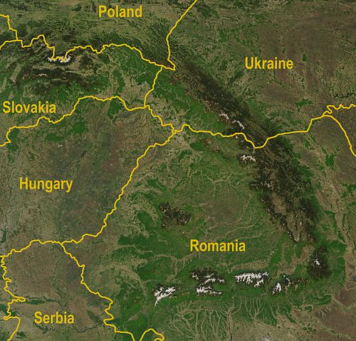
My main purpose was to create a fantasy weeklong race through the Ukrainian part of The Carpathians.
The satellite image of the Carpathians from Wikipedia:
Of course the mountains here ain’t high enough to offer the asphalted passes on 1500-2000m above the sea-level (in fact we have several passes about 900 and till 1200m). I don’t take into account dirt mountain roads which only some types of cars can drive through and such roads ain’t drawn in Google Maps so I couldn’t use them even if I wanted to") . On the other hand the quality of existing roads (first of all I’m talking about the local roads between little towns, or as the map says “roads of local importance”) should have been better (to say the least) . But as it is a fantasy race I made an assumption that all problem parts of roads are repaired and satisfactory for a road bike racing.
. On the other hand the quality of existing roads (first of all I’m talking about the local roads between little towns, or as the map says “roads of local importance”) should have been better (to say the least) . But as it is a fantasy race I made an assumption that all problem parts of roads are repaired and satisfactory for a road bike racing.
All right, let the fantasy begin
It’s called LVIV – CHERNIVTSI FANTASY TOUR. Such a name was inspired by the train on which I usually go to visit my relatives several times a year. Like a train this tour starts and ends in these two cities (Lviv and Chernivtsi) but from edition to edition it also changes its direction so one year it is Lviv – Chernivtsi and the next year it’s Chernivtsi – Lviv.
The regulations are quite easy: general, point and mountain classifications, the color of the leader’s jersey is any but yellow, I’d prefer violet just because I like the color, the bonification of 10, 6 and 4 seconds for the first three on every stage apart from tts blah blah blah…
My main purpose was to create a fantasy weeklong race through the Ukrainian part of The Carpathians.
The satellite image of the Carpathians from Wikipedia:
Of course the mountains here ain’t high enough to offer the asphalted passes on 1500-2000m above the sea-level (in fact we have several passes about 900 and till 1200m). I don’t take into account dirt mountain roads which only some types of cars can drive through and such roads ain’t drawn in Google Maps so I couldn’t use them even if I wanted to
. On the other hand the quality of existing roads (first of all I’m talking about the local roads between little towns, or as the map says “roads of local importance”) should have been better (to say the least) . But as it is a fantasy race I made an assumption that all problem parts of roads are repaired and satisfactory for a road bike racing. All right, let the fantasy begin
It’s called LVIV – CHERNIVTSI FANTASY TOUR. Such a name was inspired by the train on which I usually go to visit my relatives several times a year. Like a train this tour starts and ends in these two cities (Lviv and Chernivtsi) but from edition to edition it also changes its direction so one year it is Lviv – Chernivtsi and the next year it’s Chernivtsi – Lviv.
The regulations are quite easy: general, point and mountain classifications, the color of the leader’s jersey is any but yellow, I’d prefer violet just because I like the color, the bonification of 10, 6 and 4 seconds for the first three on every stage apart from tts blah blah blah…
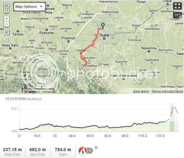
Stage 1. Lviv, ITT, 10.5km.

The route is quite hilly and technical, almost without flat straight sections. The hills are short 50-500m (not all of them are seen on the profile) with a little average gradient (4-6%), while the max gradient sometimes increases to more than 10%. The main peculiarity of the route is that about 80% of it is cobbled.
Photos:
Photo 1. Cobbles here
Photo 2. Lviv. Aerophoto.
Stage 2. Zhovkva - Skhidnytsia, 148km.
Flat stage with a non-sprinting finish. 3km before the finish line there is the pass to Skhidnytsia – 2.8km, 8% climb (the steepest part at the last 500m – 16%). The 3km of descending can hardly change things.
Photos:
Photo. 1 Zhovkva
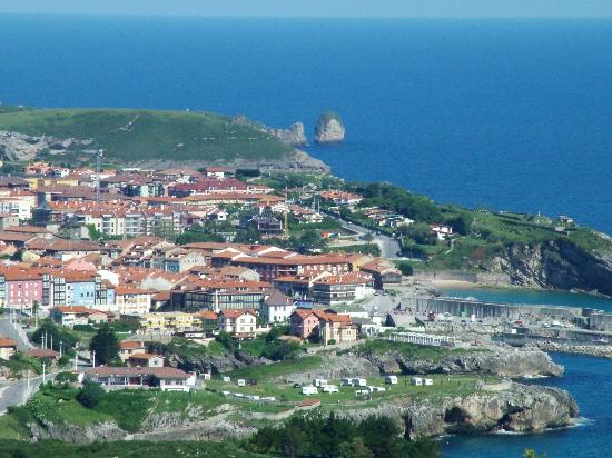
Photo 2. Skhidnytsia
Photo 3. The pass to Skhidnytsia
Stage 3. Skole - Volovets, 205km.

The first 60km ain’t hard: there are some short (under 1km) ascends without serious gradients or with little sections of steepness but not long enough to animate the race. Then we have one steep short climb 1.5km - 9.5% (max 24%) and Verecke pass - the two-level climb: 6km – 5,5% (max 13%) and 2.5km – 5,5% (max 8.5%). For increasing of a total elevation gain (and the leanth of stage) we do a 60km circuit to ride Verecke pass once more. After a descent and several little hills we lead to the narrow dirt roads (tbh in fact it isn’t fit for the road racing at all, but as I said before in a fantasy race I can make an assumption that roads are repaired) on which we have the last climb – Beskyd pass 3.6km – 7% (max 15%) 14km before the finish. Finish profile is uphill 1.4km – 6.9%.
Photos:
Photo 1. Skole
Photo 2. Verecke pass 1
Photo 3. Verecke pass 2
Photo 4. Beskyd pass
Photo 5. Volovets
The route is quite hilly and technical, almost without flat straight sections. The hills are short 50-500m (not all of them are seen on the profile) with a little average gradient (4-6%), while the max gradient sometimes increases to more than 10%. The main peculiarity of the route is that about 80% of it is cobbled.
Photos:
Photo 1. Cobbles here
Photo 2. Lviv. Aerophoto.
Stage 2. Zhovkva - Skhidnytsia, 148km.
Flat stage with a non-sprinting finish. 3km before the finish line there is the pass to Skhidnytsia – 2.8km, 8% climb (the steepest part at the last 500m – 16%). The 3km of descending can hardly change things.
Photos:
Photo. 1 Zhovkva
Photo 2. Skhidnytsia
Photo 3. The pass to Skhidnytsia
Stage 3. Skole - Volovets, 205km.
The first 60km ain’t hard: there are some short (under 1km) ascends without serious gradients or with little sections of steepness but not long enough to animate the race. Then we have one steep short climb 1.5km - 9.5% (max 24%) and Verecke pass - the two-level climb: 6km – 5,5% (max 13%) and 2.5km – 5,5% (max 8.5%). For increasing of a total elevation gain (and the leanth of stage) we do a 60km circuit to ride Verecke pass once more. After a descent and several little hills we lead to the narrow dirt roads (tbh in fact it isn’t fit for the road racing at all, but as I said before in a fantasy race I can make an assumption that roads are repaired) on which we have the last climb – Beskyd pass 3.6km – 7% (max 15%) 14km before the finish. Finish profile is uphill 1.4km – 6.9%.
Photos:
Photo 1. Skole
Photo 2. Verecke pass 1
Photo 3. Verecke pass 2
Photo 4. Beskyd pass
Photo 5. Volovets
Stage 4. Mukacheve - Rakhiv, 240km.
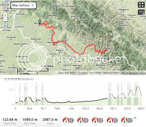
The longes and the hardest stage of the race. Several climbs at the first 50km and then more than 100km on the plain but on the last 60km the range of ascends includes: 5km – 6%, 4km – 6.3%, 3km – 7.3%, 6km – 7.6%, and the last one (7km to go) 8km – 7.7% (with the steepest section in the middle of it 2km – 16% if the map doesn’t lie ). The roads are half gravel half asphalted.
Photos:
Photo 1. Mukacheve
Photo 2. Last 60km
Photo 3. Before the finish (descend)
Photo 4. Rakhiv
Stage 5. Rakhiv - Kolomyya, 160km.

After two long stages this stage is easy one, it starts at the same town as the last stage finished. After 30km we have the Yablonitsky Pass 3.6km – 5.5%, after 100km there is another several kms of climbing a two-leveled climb about 4.5km long: first part is steeper: 2km – 8.3% (max 20%) and 2.5km – 5% (max 15%) but it is still some 60km to the finish line. There will be several short climbs (the biggest is about 1km – 6%) sooner but it shouldn’t prevent riders from a bunch sprint in Kolomyya.
Photos:
Photo 1. Yablonitsky Pass
Photo 2. Kolomyya. Near the finish line
The longes and the hardest stage of the race. Several climbs at the first 50km and then more than 100km on the plain but on the last 60km the range of ascends includes: 5km – 6%, 4km – 6.3%, 3km – 7.3%, 6km – 7.6%, and the last one (7km to go) 8km – 7.7% (with the steepest section in the middle of it 2km – 16% if the map doesn’t lie
). The roads are half gravel half asphalted.Photos:
Photo 1. Mukacheve
Photo 2. Last 60km
Photo 3. Before the finish (descend)
Photo 4. Rakhiv
Stage 5. Rakhiv - Kolomyya, 160km.
After two long stages this stage is easy one, it starts at the same town as the last stage finished. After 30km we have the Yablonitsky Pass 3.6km – 5.5%, after 100km there is another several kms of climbing a two-leveled climb about 4.5km long: first part is steeper: 2km – 8.3% (max 20%) and 2.5km – 5% (max 15%) but it is still some 60km to the finish line. There will be several short climbs (the biggest is about 1km – 6%) sooner but it shouldn’t prevent riders from a bunch sprint in Kolomyya.
Photos:
Photo 1. Yablonitsky Pass
Photo 2. Kolomyya. Near the finish line
Stage 6. Kolomyya - Vyzhnytsya, 175km.
The penultimate stage is the last last stage with some mountains. The first 100km contain some short hills (>2km) with very different gradients, then near the Romanian border there is the climb 3km – 6% and after it, 50km from the finish – the highest point of the tour – Shurdyn pass (1173m above the sea-level) 6.5km – 6%. In the last 15km there are several short hills (<1km) which come to an uphill finish 2km – 6%.
Photos:
Photo 1. Section with a gravel road near 60km
Photo 2 Shurdyn pass
Photo 3 Vyzhnytsya
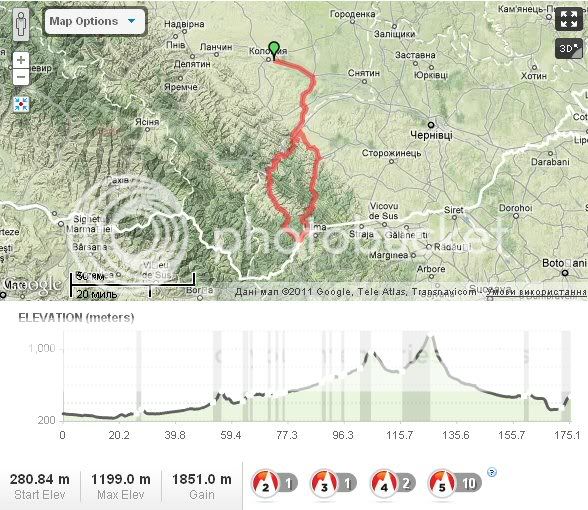
Stage 7. Snyatyn - Chernivtsi, 218km.
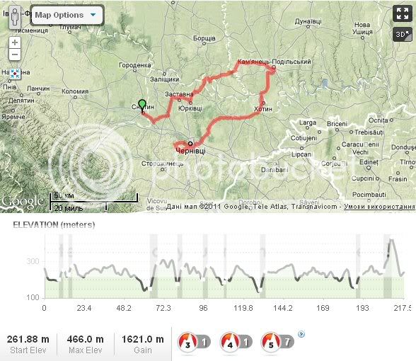
The last stage, the flat stage. Maybe not completely flat but in fact it is as hilly as the last Worlds… hmm, no, a bit hillier To animate it a little bit there are some cobbled sections in Kamianets-Podilskyi and in the and Chernivtsi is quite hilly city, the problem is to include those hills in the course but I found one, that might save the race: 9km before the finish: 2.5km – 7,1%
Photos:
Photo 1. Snyatyn
Photo 2. Kamianets-Podilskyi. The Castle and cobbles.
Photo 3. Chernivtsi
The penultimate stage is the last last stage with some mountains. The first 100km contain some short hills (>2km) with very different gradients, then near the Romanian border there is the climb 3km – 6% and after it, 50km from the finish – the highest point of the tour – Shurdyn pass (1173m above the sea-level) 6.5km – 6%. In the last 15km there are several short hills (<1km) which come to an uphill finish 2km – 6%.
Photos:
Photo 1. Section with a gravel road near 60km
Photo 2 Shurdyn pass
Photo 3 Vyzhnytsya
Stage 7. Snyatyn - Chernivtsi, 218km.
The last stage, the flat stage. Maybe not completely flat but in fact it is as hilly as the last Worlds… hmm, no, a bit hillier
To animate it a little bit there are some cobbled sections in Kamianets-Podilskyi and in the and Chernivtsi is quite hilly city, the problem is to include those hills in the course but I found one, that might save the race: 9km before the finish: 2.5km – 7,1% Photos:
Photo 1. Snyatyn
Photo 2. Kamianets-Podilskyi. The Castle and cobbles.
Photo 3. Chernivtsi
- Feb 20, 2010
- 33,267
- 15,816
- 28,180
craig1985 said:I didn't take in all of Algeria of course as the country is very large and I could have made the race longer and traveled to the southern part of the country and we did get close to the border of Morocco at one point. Perhaps this could come Africa's version of the Volta a Portugal in terms of days and some climbs in the race. It's viable for European teams as they can take the ferry across from Europe to get the team cars etc. across (unless the race sponsor puts them on) and a couple of hours by plane from most major European cities.
You did make sure to have some very long stages though! It makes complete sense to stay in the north - more towns, better infrastructure and more interesting terrain. Perhaps this could become the focal point of the UCI Africa Tour, with the occasional decent-sized European team coming in, like Geofco-Ain Benain and some of the French teams, since they're the most likely to want to, as well as some of the Iranian teams. Certainly looks like there's plenty of scope for some interesting racing there. You made sure to start and finish with some surprisingly tough stages too - no simple crit or parade finish for you, and I salute that!
Part of the problem with how the thread has come into its own is that it's now harder to actually discuss everybody's routes and for me to keep my library posts organised and structured. But we are reading everybody's posts, looking at everybody's races, promise!
L'viv-Chernivtsi looks like my kind of race - not one for the sprinters, I fear!
Also, it's taken me so long to post up my fantasy Vuelta after finishing it (I had finished designing it some time prior to starting to post it) that I already have a pretty clear design for another short stage race to come after it... the offseason is hard!


- Sep 8, 2010
- 1,441
- 0
- 0
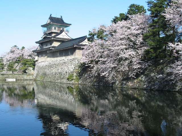
Tour of Japan || Stage 12: Yahiko Velodrome - Nagano, 167 km

The race starts from the Keirin track of Yahiko, next to a beautiful temple you can see in the picture below. The first 100 kilometers along the coast are like yesterday flat like a pan. Then we hit towards Nagano and some slight climbing starts. No big gradients. The stage will be decided after a first visit in Nagano City, because after that the peloton will head west for a loop over 7k @ 7%. So you better get your punch together. And once again you will need skills in decending, because it looks like a narrow, steep and dangerous road back down to Nagano, host of the 1998 Winter Olympics.

Climbs
Cat. 3 // Route 18 (705m), 21,2k @ 2.8%.
Cat. 1 // County Highway Route 401 (945m), 7,5k @ 7,1%
Yahikojinja Shrine

Nagano

The race starts from the Keirin track of Yahiko, next to a beautiful temple you can see in the picture below. The first 100 kilometers along the coast are like yesterday flat like a pan. Then we hit towards Nagano and some slight climbing starts. No big gradients. The stage will be decided after a first visit in Nagano City, because after that the peloton will head west for a loop over 7k @ 7%. So you better get your punch together. And once again you will need skills in decending, because it looks like a narrow, steep and dangerous road back down to Nagano, host of the 1998 Winter Olympics.
Climbs
Cat. 3 // Route 18 (705m), 21,2k @ 2.8%.
Cat. 1 // County Highway Route 401 (945m), 7,5k @ 7,1%
Yahikojinja Shrine
Nagano
Libertine Seguros said:L'viv-Chernivtsi looks like my kind of race - not one for the sprinters, I fear!
sorry for the off topic but i'm delighted that you know that correct Ukrainian spelling (using the Latin alphabet of course) is L'viv but not Lviv, like I (and many others) write for the convenience
- Feb 20, 2010
- 33,267
- 15,816
- 28,180
We move from Burgos and into La Rioja with our final transitional stage of the Vuelta...
Stage 17: Burgos - Torrecilla en Cameros, 166km

The profile of this one should tell you that the chances are the breakaway will take this one; the two climbs are likely to be too strenuous for the big sprinters to make it to the finish unharmed, but with the final climb cresting 26km from the finish and with a relatively straightforward, unchallenging run-in the likelihood of GC attacks out of anything but desperation is slim. The péloton start their journey from Burgos with a long and very gradual drag in the direction of Salas de los Infantes, before they take on the first climb of the day, the Pasil de Rozavientos. This is about two-thirds of the way up the difficult Lagunas de Neila climb, and is always climbed in the queen stage of the Vuelta a Burgos before they descend back into Quintanar de la Sierra and do the whole thing. The Vuelta will instead turn back in to Neila and cross over into La Rioja, with a long period of shallow descent and flat. The second climb of the day, the Peña Hincada, is a category 1 climb despite its relatively benign average gradient, primarily because of a difficult 3km stretch about two thirds of the way through the climb, with a maximum of 16% as you can see here. I would expect that decisive moves to cut the breakaway up will take place here, and we will have a mad dash into Torrecilla en Cameros to finish.

Climbs:
Lagunas de Neila-Pasil de Rozavientos (cat.2) 5,0km @ 7,0%
Peña Hincada (cat.1) 13,6km @ 4,9%
This will be the last day of relative rest for the guys in the maillot rojo, however - they had better be on their guard from here on in.
Peña Hincada:

Torrecilla en Cameros:

Stage 17: Burgos - Torrecilla en Cameros, 166km
The profile of this one should tell you that the chances are the breakaway will take this one; the two climbs are likely to be too strenuous for the big sprinters to make it to the finish unharmed, but with the final climb cresting 26km from the finish and with a relatively straightforward, unchallenging run-in the likelihood of GC attacks out of anything but desperation is slim. The péloton start their journey from Burgos with a long and very gradual drag in the direction of Salas de los Infantes, before they take on the first climb of the day, the Pasil de Rozavientos. This is about two-thirds of the way up the difficult Lagunas de Neila climb, and is always climbed in the queen stage of the Vuelta a Burgos before they descend back into Quintanar de la Sierra and do the whole thing. The Vuelta will instead turn back in to Neila and cross over into La Rioja, with a long period of shallow descent and flat. The second climb of the day, the Peña Hincada, is a category 1 climb despite its relatively benign average gradient, primarily because of a difficult 3km stretch about two thirds of the way through the climb, with a maximum of 16% as you can see here. I would expect that decisive moves to cut the breakaway up will take place here, and we will have a mad dash into Torrecilla en Cameros to finish.
Climbs:
Lagunas de Neila-Pasil de Rozavientos (cat.2) 5,0km @ 7,0%
Peña Hincada (cat.1) 13,6km @ 4,9%
This will be the last day of relative rest for the guys in the maillot rojo, however - they had better be on their guard from here on in.
Peña Hincada:
Torrecilla en Cameros:
TRENDING THREADS
-
 Liège - Bastogne - Liège 2026, one-day monument, 26th April
- Started by Krzysztof_O
- Replies: 1K
-
 Paris-Roubaix 2026, one day monument, April 12
- Started by Lequack
- Replies: 2K
-
 Itzulia Basque Country 2026, April 6-11
- Started by Dazed and Confused
- Replies: 2K
-
 Ronde van Vlaanderen 2026, monument, April 5 (men's)
- Started by Krzysztof_O
- Replies: 1K
-

-

-
 Teams & Riders The Remco Evenepoel is the next Eddy Merckx thread
- Started by DNP-Old
- Replies: 39K

Cyclingnews is part of Future plc, an international media group and leading digital publisher. Visit our corporate site.
© Future Publishing Limited Quay House, The Ambury, Bath BA1 1UA. All rights reserved. England and Wales company registration number 2008885.