• The Cycling News forum is looking to add some volunteer moderators with Red Rick's recent retirement. If you're interested in helping keep our discussions on track, send a direct message to @SHaines here on the forum, or use the Contact Us form to message the Community Team.

    In the meanwhile, please use the Report option if you see a post that doesn't fit within the forum rules.

    Thanks!

Race Design Thread

Page 39 - Get up to date with the latest news, scores & standings from the Cycling News Community.
This is a queen stage fo TdF that doesn't contain usual climbs since it's situated in Rhône-Alps.

Chambéry - Grenoble; 197 km

Map and profile

Climbs:
Ponte de l'Essort (cat. 2) - 11 km; 6%
Col du Granier (cat. 1) - 8,8 km; 9%
Col du Cucheron (cat. 2) - 7,4 km; 6,8% (last 2 km with 13% average)
Foret de l'Ocepé (cat. 2) - 7,8 km; 6,9%
Col de Porte (cat. 3) - 5,5 km; 7,2%
Col de Palaquit (cat. 1) - 13 km; 7,3%
Corenc (cat. 3) - 4 km; 8%
Col du Coq (cat. HC) - 13 km; 8,8%
Col de Porte (cat. 3) - 5,5 km; 7,2%

2aih75d.jpg


2uqocnd.jpg
 
Sep 8, 2010
1,441
0
0
Visit site
Torino - Bruxelles || Stage 1, Moncalieri - Como, 208 km

fyl4sz.jpg


358b3ux.jpg


Climbs
Albugnano (Cat.3, 490m) 5,1 km @ 4.6%

Second day of our little "no one needs Eneco Tour" adventure. After the hard mountain opener, we go for a real italian sprinters stage. Not complete flat but surely something for the big guys. The stage starts south of Torino in Moncalieri. From here we will travel north east through the hilly backlands of Torino. This is a ideal terrain to go for mountain points and of course to make it into a group. The second part of this stage is almost complete flat and finishes on Como's lungolario right at the lake.

Moncalieri
M.06%20castello%20di%20moncalieri.jpg.jpg


Como
lagodicomo-como2.jpg


Geez...looking for Como pictures brings up a lot of Clooney stuff. *g*
 
May 6, 2009
8,522
1
0
Visit site
togo95 said:
This is a queen stage fo TdF that doesn't contain usual climbs since it's situated in Rhône-Alps.

Chambéry - Grenoble; 197 km

Map and profile

Climbs:
Ponte de l'Essort (cat. 2) - 11 km; 6%
Col du Granier (cat. 1) - 8,8 km; 9%
Col du Cucheron (cat. 2) - 7,4 km; 6,8% (last 2 km with 13% average)
Foret de l'Ocepé (cat. 2) - 7,8 km; 6,9%
Col de Porte (cat. 3) - 5,5 km; 7,2%
Col de Palaquit (cat. 1) - 13 km; 7,3%
Corenc (cat. 3) - 4 km; 8%
Col du Coq (cat. HC) - 13 km; 8,8%
Col de Porte (cat. 3) - 5,5 km; 7,2%

2aih75d.jpg


2uqocnd.jpg

So many riders would fail to make the time cut.
 
Sep 8, 2010
1,441
0
0
Visit site
Torino - Bruxelles || Stage 2, Lugano - Julierpass, 192 km

2a68nib.jpg


2nksw03.jpg


Climbs
Passo del San Bernardino (Cat.HC, 2065m) 31,3 km @ 5,3%
Splügenpass (Cat.1, 2115m) 8,8 km @ 7,4%
Passo del Maloja (Cat.HC, 1815m) 32 km @ 4,7%
Julierpass (Cat.1, 2284m) 7 km @ 6,7%

After reaching Como yesterday, we'll have a short transfer to the other lake nearby. And so the climbing can begin. This stages features four passes, that were highly ignored by the Tour de Suisse and the Giro d'Italia. Nevertheless they were used extremely rarely by both races. But as we are not bounded to one country, we can use these climbs just like we want.

So after the start from Lugano right at lakeside the long climb up to Passo del San Bernardino starts. Like all four passes today it was already used back in the Roman days. Nowadays the pass, respectively the tunnel is besides the Passo del San Gottardo, the second most used way across the alps in Switzerland. This also means that the riders will ride next to the freeway. But since the TV isn't broadcasting the first hours, this should be no problem. :-D After a short descent and a flatter part, things heat up with Splügenpass or in Italian Passo dello Spluga. It features some serious ramps and some great views. At the pass summit we return to Italy for a few kilometers. The pass was called "Cunus Aureus" by the Romans, which means golden peak. Well, not much time to enjoy this peak, because there is a long, long descent down to Chiavenna. 30k and almost 1800hm. With bad weather conditions you can really try something on this part of the stage. Talking about rainy weather and Chiavenna, we surely think about Boasson Hagen's victory there in the 2009 Giro d'Italia. It was a very long day and Eddy the Boss among some others attacked on the descent of Passo Maloja, while some old American shat his pants. Today we will tackle Maloja from the other side and climb 32 km. Apart from the last few kilometers, this is not a difficult climb. But it is long and will make the finale harder. This brings us to the part of this stage, which I don't like that much. Between Maloja and Silvaplana there is a flat part of 10 kilometers. This can be interesting from the tactical point of view, but it can also scare off attackers. You can lose lots of energy on these kilometers, after three big mountain climbs. However in Silvaplana the final climb to the Julierpass or Pass dal Güglia starts. Especially the first two kilometers with ramps of 8-12% are perfect to launch an attack on the way to the pass summit.

Lugano
19232040.jpg


Julierpass
24417963.jpg
 
Jun 1, 2011
2,500
0
0
Visit site
One Stage Wonder?

The U.S. Pro Cycling Challenge (which Chris Horner has already renamed the Vuelta de Colorado) again is bowing entirely to idea of the host-town base of operation that is totally eliminating a real mountain-top finish.

With so many opportunities for queen-mountain stage that has true mountain-top finish, the USPCC has none. The race designers are again bypassing some of the greatest high-mountain passes in the U.S. and chance to build the tradition of mountain-pass finish and epic stages.

I cringe at the thought of short-sighted, chamber of commerce types demanding in- town finishes for the sake of attracting more money in their merchant district. Sure you can't ignore the benefit of bringing mass-crowds to the doorstep of the multitudes of tourist shops, but you could a least cut in one, just one grand MT finish.

Stage one of this year's challenge is a prime example of a missed opportunity with a Durango to Telluride route that backs out of the San Juan Mountains before turning back into there western slopes. Only one mountain pass, Lizard-Head Mountain, stands in the way before about a 20 K descent to Telluride. To be fair, the approach into Telluride has moderate incline possibilities, but my monies on the merchant district and a sprint finnish.

Ironically, Telluride is located only some seven kilometers as-the-crow flies from top of the Red Mountain pass on US route 550 which tops out at 3053 meters. A finish atop the Red Mountain Pass would be a logical extension of the Iron Horse Classic 550 route from Durango to Silverton.

OK there is a MT finish here somewhere.

http://farm3.static.flickr.com/2512/3943126714_4cafd9a15e.jpg

http://1.bp.blogspot.com/-h2uEA5wuU...AAAKQ/tBe9K0XaQPs/s1600/red+mtn+pass+drop.jpg

http://farm5.staticflickr.com/4116/4888568808_4401513d09_z.jpg

I guess you will have to link to these pics.

Three major "Cols" of Coal Bank, Molas and Red Mountain, and the preamble climb of which I will call Purgatory which offers a pitchy stair-stepping climb to the base of the Coal Bank.
 
Apr 8, 2010
1,257
0
0
Visit site
craig1985 said:
So many riders would fail to make the time cut.

Don't think so. Would probably be raced like the Grand Bornand stage in '09 (with the racing getting on at the penultimate climb), but maybe there'd be a few weak/sick riders getting dropped on the first climb. Besides it's 'only' ~5800 hm not 8700 as indicated by rwgps.
 
Sep 8, 2010
1,441
0
0
Visit site
Torino - Bruxelles || Stage 3, St.Moritz - Zürich, 209 km

4uhov6.jpg


2z7lmr6.jpg


Climbs
Passo dell' Albula (Cat.1, 2316m) 9,5 km @ 6,6%
Lenzerheide (Cat.1, 1549m) 14 km @ 5,1%
Kerenzerbergpass (Cat.2, 743m) 6,9 km @ 4,5%
Pfannenstiel (Cat.2, 821m) 5,9 km @ 4,5%

Today we have a more or less vintage transfer stage, reaching the second of four traditional cities of this race. Right after 13 kilometers the stage goes for the highest point of this race. The Albula peaks at 2316 meters and will offer a perfect opportunity for attackers and GPM collectors. Then it is downhill and the well known climb to Lenzerheide, which is long and not steep at all. After the descent we leave the higher alps and the second part of the stage begins. There we have two more smaller climbs. Of course we know Pfannenstiel from the unfortunately disappeared Züri Metzgete. With 19k to go from the summit it depends on how hard this was raced before. So maybe we will see a sprint from a reduced bunch in Zürich, but it is also probable that a group can succeed here.

St.Moritz
10485311.jpg


Zürich
8142654.jpg
 
I have returned from my little sortie, and have got around to updating the library posts with these. Torino-Bruxelles sounds very interesting and is something I had pretty much no knowledge of. It'll be interesting to see where this goes, could be lots of interesting ways to get there, and the uphill prologue reminded me of Settimana Lombarda a year or two ago.

I will resume posting my TDF shortly.
 
May 6, 2009
8,522
1
0
Visit site
I've nearly finished my Vuelta a Mexico (four stages to go), just so hard to find some good MTF's for the final week. So far I'm in the Monterrey area with the aim of finishing back in Mexico City.
 
Sep 8, 2010
1,441
0
0
Visit site
Torino - Bruxelles || Stage 4, Offene Rennbahn Zürich-Oerlikon - Belchen, 157 km

2ziy14w.jpg


2w5pt2t.jpg


Climbs
Höchenschwand (Cat.2, 1008m) 16 km @ 4,1%
Feldberg (Cat.2, 1363m) 7,8 km @ 4,7%
Wiedener Eck (Cat.2, 1031m) 10,5 km @ 4,7%
Schauinsland (Cat.1, 1194m) 8 km @ 7,7%
Belchen (Cat.1, 1320m) 10 km @ 7,5%

The fifth day of our adventure will bring us back on the GC with a rough mountain stage settled between medium mountains and high mountains. The riders will really have to step up here. But first things first.

Today's stage will start a few kilometers north of Zürich in the quartier of Oerlikon. Here the race takes of on the so called "Offene Rennbahn", which is a open air velodrome build back in 1912. The track is used, for today only as a start. After 38 kilometers the peloton will reach Germany and from here the climbing will begin.
The first climb of the day brings us into the small village of Höchenschwand. It is also the longest climb of the day, but nothing really serious. Besides if a group hasn't been established yet, it will happen here. For the next 23 km the stage takes place on a plateau. But after passing the Schluchsee, things will get more difficult in this southern area of the Black Forest. Riders now climb the road up to the highest mountain of the region, called Feldberg. They won't climb it to the top, but the GPM isn't far from it. If you're climbing from another direction this climb can be really hard. After the long descent, the climb to Wiedener Eck brings us nothing special, but with the Schauinsland road, things heat up a lot. Three kilometers at 11-12% will make this hard and will tear the peloton in pieces, if a team really wants this. Anyhow there is another descent for about 15 kilometers, before the riders go for the final climb of the day. The road up the Belchen (or Ballon in French) is a rhythmic climb with gradients of 6-8%. Since we are heading north and the climbs won't get bigger, the climbing specialists have to do their magic here.

Offene Rennbahn Zürich-Oerlikon
5404215.jpg


Belchen
16484018.jpg
 
Time for something else. An Österreich Rundfahrt without the Kitzbüheler Horn.

Stage 1: Feldkirch-Seefeld, 192km

It gets kinda gets tricky right from the start.

http://www.tracks4bikers.com/tracks/show/81985

Arlbergpass after 55km to warm the riders up and then it's a climb to Seefeld with a couple of brutal kilometers in the double digits followed a few km later by a climb (from Bairbach) of the Buchener Sattel with 13.5km and another small climb before the finish in Seefeld.

Stage 2: Innsbruck-Kitzbühel, 169km

A flat stage to Kitzbühel.

Stage 3: Fieberbrunn-Obertilliach, 191km

http://www.tracks4bikers.com/tracks/show/81964

A GC irrelevant climb of the Grossglockner included for the sake of tradition, Iselsbergpass, Bannberg, the rest of the Pustertaler Höhenstrasse (from right to left from Bannberg), a small steep climb to Tessenberg and the final drag of the Kartitscher Sattel 6.5km before the finish

Stage 4: Obertilliach-Sankt Michael im Lungau

http://www.tracks4bikers.com/tracks/show/81963

Windische Höhe, a small climb to Glanz, Wiedweg, the 2 climbs of the Nockalm Höhenstrasse and then the final surprise.

The Katschberghöhe. One can guess from this photo what awaits. Luckily the really steep part is only 3km long but with an average of 12% and just the even steeper downhill to go some good time can be made.

Stage 5: Salzburg-Linz, 155km

second flat stage

Stage 6: Linz-Jauerling, 161km

http://www.tracks4bikers.com/tracks/show/81966

The one and only MTF, by road Vienna is only 100km away which means that the race end is near. The climb itself is about 8km but the initial 5km are about 10% in average which while not exactly the Kitzbüheler Horn makes it a quite difficult climb

Stage 7: Podersdorf am Neusiedler See ITT, 24 km

As it's a course where time gains on any stage are incomparable to the usual Kitzbüheler Horn finish, the TT is somewhat on the shorter side

Stage 8: Podersdorf-Vienna, 123km

The usual finish
 
Now this I like. I had been playing about with an Österreichrundfahrt myself a while back but abandoned the plan. I decided to go from East to West rather than the usual however, intending to finish in Innsbruck rather than Wien. It's interesting (and pleasing) to see some of the steep stuff you've found there, not only different from the traditional choices of the race but also most of the options I was looking at (Weinebene, Naßfeldpass and Kaunertal were the mooted main climbs, for the record).
 
I'm going to get back to my Tour now, after a few days out.

Stage 11: Tarbes - Seix, 170km

2hek9yx.jpg


2agqofd.png


Climbs:
Oueilloux (cat.4) 1,7km @ 6,2%
Côte de Sarrat (cat.3) 3,8km @ 5,9%
Mont de Galié (cat.3) 2,7km @ 9,0%
Col des Ares de Boudancio (cat.3) 4,9km @ 5,7%
Col de Larrieu (cat.3) 6,0km @ 3,7%
Col de Portech (cat.2) 8,4km @ 5,1%
Col de Catchaudégué (cat.3) 5,4km @ 5,4%

Points:
Aspet, 100km
Seix (Avenue de la Barraqué), finish

Yes, this is probably the most sacreligious stage in my Tour; a transitional medium climbing stage through the heart of the Pyrénées. It starts badly for traditionalists; the transfer from the finish of the epic stage 10 to the départ for today takes us PAST famous Tour stop-offs like Pau, Lourdes, Luz-Saint-Sauveur and Oloron-Sainte-Marie. Instead, we will start off from Tarbes; this city of over 100,000 on the western edge of Midi-Pyrénées has been in vogue somewhat in recent years in the Tour, but today we are not heading for the summit finishes like in 2001 (Luz Ardiden) and 2006 (Pla de Beret), nor are we finishing a woefully inappropriate mountain stage here like in 2009. Instead it's a medium mountain stage as we roll over the Pyrenean foothills, bypassing familiar favourites like the Tourmalet, Aspin, Peyresourde, Aubisque, Luz Ardiden, Hautacam and so on.

The theme for the day is established in the early going, with a cat.4 and a cat.3 climb punctuating the first 30 kilometres, before a long, flat stretch around Lannemezan that will allow a breakaway to make some distance on the péloton - it is likely to be a good day for one of them, for after yesterday's slaughter, the GC men will likely be keen to allow them to disappear never to be seen again and fight the stage between them. This flat ends when we head in to the foothills of the Pyrénées proper, where the riders will be faced with a difficult one-two punch of climbs; Mont-de-Galié is short but is the steepest climb of the day, averaging out at 9%, and heads straight into the Col des Ares, longer but more benign.

A descent punctuated by a couple of short uphills on a period of flat follows, leading us in to the intermediate sprint in the town of Aspet. This could be a good opportunity for a classics man or puncheur who is in contention for the points jersey to pick up some good points not available to the purest of sprinters, as I've tried to keep a range of options to keep the points competition interesting. After Aspet, instead of the typical switch to the south for the common climb up to the Portet d'Aspet and the Casartelli memorial thereon, we take the gradual rise up to the Col de Larrieu before a rolling stretch with some uncategorised climbs around Cazavet and Saint-Lizier, leading us into our final double act of the day.

The Col de Portech is not one of the toughest climbs France has to offer, by a long stretch. But it does get quite steep for a short while, that period of 11% near the top, and the climb cresting 17km from home could well mean that somebody, either in the break or in the main bunch, is tempted to hit for home; though GC action could be limited, certainly the competition for a stage win can be fierce. The descent taking us partway between La Rivière and Alos is short, and then we tackle the final 5,4 kilometres of the Col de Catchaudégué, a gloriously inconsistent climb which has some steep ramps (a max of 15%) but much of its distance is unthreatening. Certainly there are a couple of ramps that can serve as a basis for an attack if anybody desires it, before that flattish final couple of kilometres. From there it's a technical descent into Seix, finishing with a short (ca. 2km) lap around the town to make the finish a bit safer.

There we have it; a transitional stage in the Midi-Pyrénées. Traditionalists will hate it, but fear not, for there is plenty to sate the mountain fan still to come.

Tarbes:
vue-de-tarbes.jpg


Seix:
04a-Seix.jpg
 
Sep 8, 2010
1,441
0
0
Visit site
will10 said:
That stage screams Luis Leon Sanchez to me. Looking forward to the mountain stages you've conjured up :)

Yep, after losing 25 minutes on stage 10. :D

This is perfect for a transitional stage. Prudhomme would have gone over Tourmalet etc. and then added 50k of flat to it, which is way more offending the traditionalists, than having a stage like this one.

Still waiting curiously for this stage violating the UCI rules. :D
 
Stage 12: Foix - Mantet, 180km

25h0mmx.png


29ejhoh.png


Climbs:
Col de Chioula (cat.1) 9,7km @ 7,3%
Col des Sept Frères (cat.4) 1,2km @ 7,1%
Col de Dent (cat.2) 13,4km @ 4,0%
Col de Jau (cat.1) 13,4km @ 6,7%
Col de Mantet (HC) 21,3km @ 6,1%

Points:
Prades (Avenida Louis Prat), 151km
Mantet (Parking), finish

With stage 12 the Pyrénées come back to bite the riders again, with them now facing the first major mountaintop finish of the race, and I've sought out a brand new, unused-by-the-Tour summits for the occasion. The partly-Catalan Pyrénées-Orientales region is our goal here, as we travel as far east across the range as Le Tour has ever ventured to go.

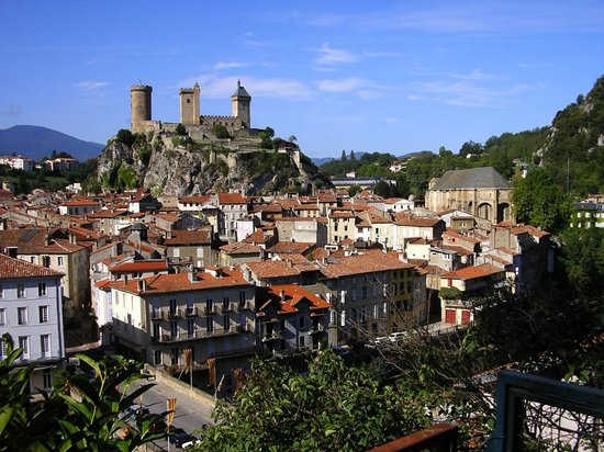
We start off, however, after a short transfer post-stage 11, in Foix, the administrative centre of the Ariège département. The city has hosted the Tour twice in recent memory; firstly as the start of a mountain stage to Loudenvielle in 2007 (won by Alexander Vinokourov), and then as the finish of a transitional stage in 2008 (won by Kurt-Asle Arvesen). Today it is more like 2007, though that stage was in a year of clockwise travel and thus more conventional than today's trek into the eastern Pyrénées. However, before the mountain tests can begin, there are 40 kilometres of uphill false flat before we arrive at a common Tour spot, Ax-les-Thermes.

From Ax-les-Thermes you could be forgiven for expecting a trek up to a finish at Bonascre/Ax-3-Domaines, but of course the stage would not be that short. There are a number of major climbs to be found to the north of the town; the Port de Pailhères is perhaps the toughest, but Pradel is far from easy too. I've gone for a slightly easier climb, to ease the riders in to the day's challenge; the Col de Chioula is somewhat shorter, but has the benefit of steepness; that final stretch averaging over 9% will certainly be felt by the end of the day. The climb is not the steepest or the highest, but serves as a nice category 1 warmup for the rest of the stage. At first, the downhill is gradual, before being interrupted by the cat.4 climb of the Col des Sept-Frères; after this it is a more typical descent down to Niort-de-Sault. After this the riders start the staggeringly inconsistent category 2 ascent of the Col de Dent. Including some sections of descent and false flat, the climb is tougher than the 4,0% average gradient would have you believe, though it doesn't really get above 9% at any point. From there it's a technical descent into Axat via this route, which will challenge the riders' skill and nerve before the day really heats up.

The penultimate climb of the day could see some action; it is plenty tough enough to see some contenders shelled if the pain is brought, but it is likely to be more by attrition than attack. The Col de Jau is the eastermost Pyrenéan climb that the Tour has ever used, and here we are using the harder and better western side of it, from Axat via Sainte-Colombe-sur-Guette. The toughest sections are at the bottom, which will dislodge quite a few riders who will then have to suffer with the autobus on the way up the dramatic slopes and twists and turns of the Jau and make a bid to stay inside the time limit. There is also a difficult section in the middle, but generally this stays in the region where riders can get into a good rhythm until they crest the summit, after which there will be 55 kilometres to go.

The first 23 kilometres of this are descent; the first half of these are fairly typical but the second half is just false downhill flat as we head into the French-Catalan city of 
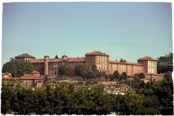
Prades for the intermediate sprint of the day; few sprinters or classics men will be around to contest this, however. After this the false flat switches from downhill to uphill, and eventually we turn left from the N116 after 6 kilometres at this fetching castle here, and the road turns upwards again. At first false flat, but by the time we get to the village of Sahorre the riders will be acutely aware that they are starting to head uphill; by the time they get to Py there will be no turning back. Yes, it's a brand new summit finish for the Tour; the long, epic Col de Mantet. 21 kilometres, an average of over 6%, and in the second half it never lets up below 7%, maxing out at 16%. The riders may have saved some energy yesterday, but now it's time for them to bring it all out.

Once the riders are snaking their way elegantly up the mountainside, they will be in a national park, which will probably be clear anyway from the scenery, the road condition, and the jawdropping backdrop. No time to appreciate the scenery for the riders, of course, until they reach 
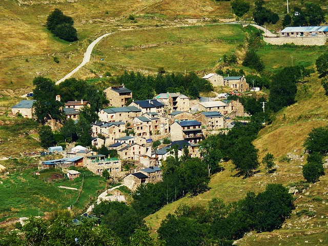
the summit. Not a great deal of room at the summit though, unfortunately, so the riders will face a 2km downhill to the finish, at the parking place just before arriving in the isolated village of Mantet. This also enables vehicles to park up on the road on the way further down, allowing the riders to come in in peace.

There is a good chance that this will, in terms of action, be a one-climb stage; but then, I've made sure the riders have plenty of uphill action in their legs ahead of that final climb, and also made sure to innovate a bit with which climbs to use. And besides; it's our first real MTF (sort of, can't really call the 2km from the Col de Mantet to the outskirts of the village a real descent finish) coming near the end of week 2. There's quite a long transfer waiting for the riders after the stage, so there will be little rest ahead of tomorrow.

Foix:
the-chateau-and-town.jpg


Mantet:
6568935857_d772ae39a7_z.jpg
 
Sep 8, 2010
1,441
0
0
Visit site
Torino - Bruxelles || Stage 5, Freiburg - Karlsruhe, 156 km

10pvucn.jpg


mpw8k.jpg


Climbs
Wattkopf (Cat.3, 325m) 4,2 km @ 4,4%

Right now from were we are, there are lots of possibilities to go for Luxembourg. I decided to do the sprinters a favor and give them an almost dead flat stage along the Rhine and the Frech-German border. Things shouldn't be too easy, so I put in a short climb. Guess this will stop no one besides Guardini.

Freiburg
5089772.jpg


Karlsruhe
36652445.jpg
 
Jun 1, 2011
2,500
0
0
Visit site
BillytheKid said:
Ironically, Telluride is located only some seven kilometers as-the-crow flies from top of the Red Mountain pass on US route 550 which tops out at 3053 meters. A finish atop the Red Mountain Pass would be a logical extension of the Iron Horse Classic 550 route from Durango to Silverton.

OK there is a MT finish here somewhere.

http://farm3.static.flickr.com/2512/3943126714_4cafd9a15e.jpg

http://1.bp.blogspot.com/-h2uEA5wuU...AAAKQ/tBe9K0XaQPs/s1600/red+mtn+pass+drop.jpg

http://farm5.staticflickr.com/4116/4888568808_4401513d09_z.jpg

I guess you will have to link to these pics.

Three major "Cols" of Coal Bank, Molas and Red Mountain, and the preamble climb of which I will call Purgatory which offers a pitchy stair-stepping climb to the base of the Coal Bank.

Telluride will be the finish of stage one. Will it be a flat run in to the town below or hopefully an uphill finish at the new Mountain Village over the ski on the far ridge?

20100513__20100516_T09_TR16TELLURIDE~p1.JPG

Telluride, Colorado sits in a box canyon that ends abruptly (below). The ski area can bee seen on the facing ridge. Telluride Mountain Village sits just over that Ridge and offers an best chance at a uphill finish on the opposite slope.

fireworks_over_mountain_village.jpg


This winter view shows the Telluride Mountain Village, right, and Telluride in the valley, left. There's at least some elevation gain.

Telluride.jpg


Just west of Telluride is the mining village of Pandora (somebody had a sense of humor) with the box canyon bit.) You can see a jeep trail notch into lower mountain. It will take you up through Black Bear Pass at the foot of Telluride Mountain to join the Red Mountain Pass (my original pick for the finish of this stage)Except for the lower switch backs it becomes an mountain bike ride only.
 
Library Post

Fictional Stage Races (Eastern Europe)

Friedensfahrt/Peace Race [WPB] (Libertine Seguros) Intro Prologue Stage 1 Stage 2 Stage 3 Stage 4 Stage 5 Stage 6 Stage 7 Stage 8 Stage 9 Stage 10 Stage 11 Stage 12 Stage 13 Stage 14

Friedensfahrt/Peace Race [WBP] (Libertine Seguros) Stage 1a Stage 1b Stage 2 Stage 3 Stage 4 Stage 5 Stage 6a Stage 6b Stage 7 Stage 8 Stage 9 Stage 10 Stage 11 Stage 12 Stage 13 Stage 14 Stage 15

Friedensfahrt/Peace Race [BPW] (roundabout) Entire parcours

L'viv-Chernivtsi Tour (Kvinto) first editionStages 1-3 Stages 4 & 5 Stages 6 & 7 second edition Stages 1 & 2 Stages 3 - 5 Stages 6 & 7

Tour of Hungary (togo95): Stage 1 Stage 2 Stage 3 Stage 4 Stage 5 Stage 6 Stage 7 Stage 8

Tour of Russia (Libertine Seguros): Stage 1 Stage 2 Stage 3 Stage 4 Stage 5 Stage 6 Stage 7 Stage 8

Tour of Slovakia (togo95): Stage 1 Stage 2 Stage 3 Stage 4 Stage 5 Stage 6 Stage 7 Stage 8

Tour of the Czech Republic (roundabout) Stages 1-7

Turul Transilvaniei (McLovin) Stage 1 Stage 2 Stage 3 Stage 4 Stage 5 Stage 6 Stage 7 Stage 8

Závod Zl?*nským krajem (togo95): Prologue Stage 1 Stage 2 Stage 3 Stage 4

More will be added here as they are posted. All library posts are linked from the original post in the thread.
 
Sep 8, 2010
1,441
0
0
Visit site
Torino - Bruxelles || Stage 6, Karlsruhe - Luxembourg, 266 km

2zi51rr.jpg


2lm7xue.jpg


Climbs
Orscholz (Cat.3, 385m) 4,6 km @ 4,3%

Time to satisfy my love for long stages. The next two stages will feature classic length of over 250 kilometers. This stage here is for the sprinters, tomorrow's stage is for the GC riders and stage hunters.

From Karlsruhe the stage enters France and crosses the national park of "Vosges du Nord". I really thought about a stage in the classic Vosges, but I think that this kind of terrain is covered with my stage in the Black Forest. In Sarreguemines the stage returns to Germany and heads north. After passing by the Saarschleife, the only categorized climb of the day starts. From here it is a little bit of up and down.
Optional you can go for an uphill sprint at the Fort Thüngen. But since I couldn't find out about the roads there, I put that idea aside. So this is gonna be a normal sprint royal.

Karlsruhe
1938671.jpg


Luxembourg
5766886.jpg
 
GP Lac Léman: Lausanne - Lausanne; 236 km

Start and finish located in one of my favourite cities - Lausanne. With good weather, this would be an amazing one-day race to watch, with such great sceneries of Lac Léman and surroundings.
Riders will go around Lac Léman counterclockwise. First climb is on the menu is 33 km from start. Descent from it ends in Nyon, and then the route head to Genéve through rolling terrain and also they will get into France for the first time. In Genéve route turns direction to east and we are going through borders into France once again. This time, the part in France is over 80 km long, and there is another climb there. Starting from Thonon-les-Bains, the climb to Vinzier is 15 km long.
After the descent there is flat terrain for over 40 km, ending in Vevey (Suisse), 37 km before finish. From now on the longest flat part is no mre than 5 km long. Next climb is Mont Pélerin, though riders will climb just half of the road to the top (30 km to the finish line). Descent is very technical and on narrow roads. It is followed by a 5 km long stretch along the shore of Lac Léman. Next climb - Bossiéres is 3,5 km long and it's very inconsistent, the steepest 500 metres have an average gradient 17%. The top of this climb is only 16 km from finish, and two hill are still here to be climbed.
Another short flat part brings riders into Lausanne already. Second to last climb is Bois Mermel just under the airport in Lausanne. It is almost 5 km long, and from the top only 5 km remain to finish. Firstly, cyclist must descent to Chateau d'Ouchy, and the last km is on the straight Avenue d'Ouchy with average 10% slope.
This race would be probably most interesting in the last 35 km with so many places to attack.

Link

Climbs:
Bois d'Outard - 18 km; 5,3%
Vinzier - 14 km; 4,3%
Mont Pélerin - 6,1 km; 8,8%
Bossiéres - 3,4 km; 7%
Bois Mermel - 5 km; 4,8%
Avenue d'Ouchy - 1,1 km; 10,4%

2dmiaza.png


29x9lds.png


Lac Léman:
34j3t50.jpg


Lausanne:
21bq9a9.jpg
 
May 6, 2009
8,522
1
0
Visit site
togo95 said:
GP Lac Léman: Lausanne - Lausanne; 236 km

Start and finish located in one of my favourite cities - Lausanne. With good weather, this would be an amazing one-day race to watch, with such great sceneries of Lac Léman and surroundings.
Riders will go around Lac Léman counterclockwise. First climb is on the menu is 33 km from start. Descent from it ends in Nyon, and then the route head to Genéve through rolling terrain and also they will get into France for the first time. In Genéve route turns direction to east and we are going through borders into France once again. This time, the part in France is over 80 km long, and there is another climb there. Starting from Thonon-les-Bains, the climb to Vinzier is 15 km long.
After the descent there is flat terrain for over 40 km, ending in Vevey (Suisse), 37 km before finish. From now on the longest flat part is no mre than 5 km long. Next climb is Mont Pélerin, though riders will climb just half of the road to the top (30 km to the finish line). Descent is very technical and on narrow roads. It is followed by a 5 km long stretch along the shore of Lac Léman. Next climb - Bossiéres is 3,5 km long and it's very inconsistent, the steepest 500 metres have an average gradient 17%. The top of this climb is only 16 km from finish, and two hill are still here to be climbed.
Another short flat part brings riders into Lausanne already. Second to last climb is Bois Mermel just under the airport in Lausanne. It is almost 5 km long, and from the top only 5 km remain to finish. Firstly, cyclist must descent to Chateau d'Ouchy, and the last km is on the straight Avenue d'Ouchy with average 10% slope.
This race would be probably most interesting in the last 35 km with so many places to attack.

Link

Climbs:
Bois d'Outard - 18 km; 5,3%
Vinzier - 14 km; 4,3%
Mont Pélerin - 6,1 km; 8,8%
Bossiéres - 3,4 km; 7%
Bois Mermel - 5 km; 4,8%
Avenue d'Ouchy - 1,1 km; 10,4%

2dmiaza.png


29x9lds.png


Lac Léman:
34j3t50.jpg


Lausanne:
21bq9a9.jpg

If the UCI wanted a new Swiss WT race to take over the spot of Züri-Metzgete then you won't go wrong with this one. Maybe at the start you could add an extra 20km to make it 256km and I'm sure one of the most scenic. It could also be a great lead up race for Lombardia if you didn't want to give them WT status.