• The Cycling News forum is looking to add some volunteer moderators with Red Rick's recent retirement. If you're interested in helping keep our discussions on track, send a direct message to @SHaines here on the forum, or use the Contact Us form to message the Community Team.

    In the meanwhile, please use the Report option if you see a post that doesn't fit within the forum rules.

    Thanks!

Race Design Thread

Page 40 - Get up to date with the latest news, scores & standings from the Cycling News Community.
Jun 1, 2011
2,500
0
0
Visit site
Libertine Seguros said:
Stage 12: Foix - Mantet, 180km

25h0mmx.png


29ejhoh.png


Climbs:
Col de Chioula (cat.1) 9,7km @ 7,3%
Col des Sept Frères (cat.4) 1,2km @ 7,1%
Col de Dent (cat.2) 13,4km @ 4,0%
Col de Jau (cat.1) 13,4km @ 6,7%
Col de Mantet (HC) 21,3km @ 6,1%

Points:
Prades (Avenida Louis Prat), 151km
Mantet (Parking), finish
]

Libertine, this is great detail. What mapping software are you using?
 
Stage 13: Narbonne - Lunel, 154km

dp7m8k.png


15hbxw5.png


Climbs:
Mont Saint-Clair (cat.3) 2,7km @ 6,3%

Points:
Villeneuve-lès-Maguelones (Avenue de Mireval), 105km
Lunel (Boulevard de Sainte-Claire), finish

As we head towards the penultimate weekend, the riders get the chance to give their weary climbing legs a rest after the travails on the Col de Mantet yesterday. Instead, it's a relatively straightforward flat stage, with a solitary climb to mark it, and its relatively short length will probably also come as blessed relief for the riders.

Before the départ there is the small matter of a quite lengthy transfer from the mountains of Pyrénées-Orientales to the city of Narbonne, in the Aude region. The stage begins benignly enough with a flat, slightly rolling first 30 kilometres into Beziers. The break of the day should be able to go here; as a transitional day the péloton may be happy to let them go; it will probably depend on how toughly the race is raced (er) in the main bunch later on; sprinter's teams may feel the need to take advantage of the few opportunities that the rest of the parcours offers them. Once in Beziers, the riders will turn right, towards the coast and the seaport of Agde alongside the Canal du Midi. A slight, almost imperceptible rise around the perimeter of Mont Saint-Loup, which separates the city of Agde from the notorious Cap d'Agde, takes us to the edge of the Étang de Thau, the largest of a series of inland lakes close to the Mediterranean coast; the riders now face 15km of extremely flat racing on a thin band of coastline between the two bodies of water, before arriving in Sète.

Sète contains our only categorised climb of the day, the cat.3 ascent of Mont Saint-Clair, a hill upon which the city has been built; it is not threatening to all but the most appalling of climbers, but it does mean that some of the sprinters who are least capable of dealing with uphill stretches may be further down in the péloton than they may like should splits occur. This is the last time we'll be more than 10m above sea level today.

Should the wind blow from the Mediterranean coast, of course, then there is a good chance that such splits could occur; almost all of the over 70km remaining in the stage take place right on the coastline, taking in the D60 Avenue des Étangs through Frontignan, briefly turning inland for roads do not pass on the thin strip of land between the Étang de Vic and the Mediterranean, whereas elsewhere this thin band of exposed coastline makes for an ideal spot to let the strongmen take control and form echelons. This detour takes us through the towns of Vic-la-Gardiole, Mireval and finally Villeneuve-lès-Maguelone, where the intermediate sprint for the day will take place, where the sprinters will hope to claw some points if the rouleurs haven't caused too much trouble with the echelons already.

Now turning back to the roads that sit on the exposed, open strips of land separating Les Étangs from La Mer, the péloton head through Palavas-les-Flots to the town of La Grande Motte, a tourist spot that hosted the Tour in 2009, when the wind blew and the péloton split apart, with Armstrong ahead and Contador behind; both the points jersey contenders and the GC men will want to make sure that they are in the right place in the péloton - nobody wants their chances ruined by a split in the péloton here, so they will have to be vigilant. The ordeal is not yet over; we continue on to Le Grau-de-Roi and turn left across the Étangs to Aigues-Mortes; with 18km left the riders will turn back inland and breathe a very loud sigh of relief, as though completely and utterly flat, and probably still windy, the run-in to Lunel is less totally exposed.

This is certainly a day when the péloton could let the break go, but with the green jersey outcomes still hopefully hanging in the balance, the sprinters' teams will want to control this one, while the rouleurs will be trying to break their resolve and split the péloton up; it will test the GC riders' strength and brains ahead of the penultimate weekend's challenges. They will probably be thankful the stage is short.

Narbonne:
narbonne_3_cr_000.jpg


Lunel:
lunel0.jpg
 
May 24, 2010
855
1
0
Visit site
Fantasy time again, been working on a killer race through the Alps purely for climbers, no sprint stages, a hilly TT and I think some cracking stages. 9 stages, two rest days but at the minute I'm not quite there just yet, I'll post when I'm completely happy with it.
 
Speaking of mountains... let's try and make an intermediate stage a bit more decisive.

Stage 14: Salon-de-Provence - Toulon (Mont Faron), 150km

2wgyiw6.png


107uaud.png


Climbs:
Côte de Belcodène (cat.3) 6,9km @ 2,5%
Col de Roussargue (cat.2) 10,2km @ 5,0%
Montée du Vieux-Camp (cat.3) 5,6km @ 3,6%
Évenos (cat.3) 1,6km @ 11,4%
Mont Faron (cat.2) 5,5km @ 9,0%

Points:
Auriol (Chemin de St-Pierre), 66km
Toulon (Mont Faron), finish

Our second mountaintop finish comes off the back of a shortish intermediate stage, with my inspiration here being the types of stages we see to Peña Cabarga in the Vuelta; the gaps may not be extreme on such a short mountaintop, but time is most definitely there to be gained if the riders are daring enough as we move through Provence towards a finish overlooking the Côte d'Azur. Again, as a transitional stage it might be a good day for the breakaway if the GC candidates don't fancy duking out the win; the sprinters' teams certainly aren't going to fancy it with a finish like this. Expect a break containing the usual suspects for a stage like this - Pierrick Fedrigo, Carlos Barredo, Jan Bakelandts and the like.

The stage starts in the city of Salon-de-Provence, under the watchful gaze of the majestic Château de l'Empéri. The riders will head east out of Salon-de-Provence for a rolling stretch, with the road being at first gradually uphill before giving way to a bumpy period of racing around the larger Mistralian city of Aix-en-Provence. The rolling characteristics are continued with our first climb of the day, consisting of two slightly steeper stretches with a piece of flat in between. The Côte de Belcodène is fairly easy, so all but the most incompetent climbers should still be in the bunch to contend for any remaining intermediate sprint points at Auriol shortly afterward.

The second half of the stage is somewhat less rolling, however, and more lumpy. This begins with the scenic Col de Roussargue, just above the Col d'Espigoulier, which will be the first thing to thin the péloton out, at 10 kilometres in length and 5% average. At 728m it is also the high point of the day's proceedings, much to the pleasure of those who cannot climb. The descent into Gémenos is tough and technical, with several hairpins to negotiate and put the fear of God into Andy Schleck and Ivan Basso. After this we have the uncategorised drag up the Col de l'Ange, before the gradual, unthreatening ascent of Montée du Vieux-Camp. The descent from here is trickier than the climb, but still not especially threatening, before another uncategorised climb at Le Castellet, home of the motor racing Circuit Paul Ricard, and then some gradual, imperceptible and very very straight downhill leads us to 25 to go.

Here, the riders get a nasty shock, as the road ramps up to extreme proportions. The Chemin de la Basse Venette, the road to the mountaintop village of Évenos is very steep, averaging out at 11% for just over a kilometre and a half, and is quite narrow, so good placement for the key riders is essential if they don't want to waste too much energy on the way to the Col du Corps de Garde, or have to take too many risks on the descent into Toulon, because they will need that energy so as not to suffer on the slopes of Mont Faron.

Though a fixture in the Tour Meditérranéen and not an uncommon stop-off for Paris-Nice, you may be surprised to learn that Mont Faron has only been featured in Le Tour once, in 1957, when Jean Stablinski triumphed. Its slopes are steeper than the Tour's norm, as you can see here; however unlike it's Spanish counterpart, it wears its steepest gradients at the bottom (that second kilometre averaging over 11% and the steepest gradient being 16%) and is fairly consistent after that, so riders hoping to make the most of this climb will need to go near the bottom. However, there are a lot of hairpins further up, so those favouring the 'out of sight, out of mind' approach can take advantage of that. I expect the gaps here to be fairly small, but the climbers certainly have a chance to take some time from the more TT-oriented GC guys, who could well struggle on these steeper-than-the-norm slopes on narrow roads. Still, like Peña Cabarga, the proximity to a big city and the spectacular views of the coast make this a scenic and attractive stage finish.

Salon-en-Provence:
salon-vue-de-la-ville.jpg


Toulon (Mont Faron):
1232320857_16df4444a5_z.jpg
 
Jun 1, 2011
2,500
0
0
Visit site
Libertine Seguros said:
Speaking of mountains... let's try and make an intermediate stage a bit more decisive.


Our second mountaintop finish comes off the back of a shortish intermediate stage, with my inspiration here being the types of stages we see to Peña Cabarga in the Vuelta; the gaps may not be extreme on such a short mountaintop, but time is most definitely there to be gained if the riders are daring enough as we move through Provence towards a finish overlooking the Côte d'Azur. Again, as a transitional stage it might be a good day for the breakaway if the GC candidates don't fancy duking out the win; the sprinters' teams certainly aren't going to fancy it with a finish like this. Expect a break containing the usual suspects for a stage like this - Pierrick Fedrigo, Carlos Barredo, Jan Bakelandts and the like.

The stage starts in the city of Salon-de-Provence, under the watchful gaze of the majestic Château de l'Empéri. The riders will head east out of Salon-de-Provence for a rolling stretch, with the road being at first gradually uphill before giving way to a bumpy period of racing around the larger Mistralian city of Aix-en-Provence. The rolling characteristics are continued with our first climb of the day, consisting of two slightly steeper stretches with a piece of flat in between. The Côte de Belcodène is fairly easy, so all but the most incompetent climbers should still be in the bunch to contend for any remaining intermediate sprint points at Auriol shortly afterward.

The second half of the stage is somewhat less rolling, however, and more lumpy. This begins with the scenic Col de Roussargue, just above the Col d'Espigoulier, which will be the first thing to thin the péloton out, at 10 kilometres in length and 5% average. At 728m it is also the high point of the day's proceedings, much to the pleasure of those who cannot climb. The descent into Gémenos is tough and technical, with several hairpins to negotiate and put the fear of God into Andy Schleck and Ivan Basso. After this we have the uncategorised drag up the Col de l'Ange, before the gradual, unthreatening ascent of Montée du Vieux-Camp. The descent from here is trickier than the climb, but still not especially threatening, before another uncategorised climb at Le Castellet, home of the motor racing Circuit Paul Ricard, and then some gradual, imperceptible and very very straight downhill leads us to 25 to go.

Here, the riders get a nasty shock, as the road ramps up to extreme proportions. The Chemin de la Basse Venette, the road to the mountaintop village of Évenos is very steep, averaging out at 11% for just over a kilometre and a half, and is quite narrow, so good placement for the key riders is essential if they don't want to waste too much energy on the way to the Col du Corps de Garde, or have to take too many risks on the descent into Toulon, because they will need that energy so as not to suffer on the slopes of Mont Faron.

Though a fixture in the Tour Meditérranéen and not an uncommon stop-off for Paris-Nice, you may be surprised to learn that Mont Faron has only been featured in Le Tour once, in 1957, when Jean Stablinski triumphed. Its slopes are steeper than the Tour's norm, as you can see here; however unlike it's Spanish counterpart, it wears its steepest gradients at the bottom (that second kilometre averaging over 11% and the steepest gradient being 16%) and is fairly consistent after that, so riders hoping to make the most of this climb will need to go near the bottom. However, there are a lot of hairpins further up, so those favouring the 'out of sight, out of mind' approach can take advantage of that. I expect the gaps here to be fairly small, but the climbers certainly have a chance to take some time from the more TT-oriented GC guys, who could well struggle on these steeper-than-the-norm slopes on narrow roads. Still, like Peña Cabarga, the proximity to a big city and the spectacular views of the coast make this a scenic and attractive stage finish.

Salon-en-Provence:
salon-vue-de-la-ville.jpg


Toulon (Mont Faron):
1232320857_16df4444a5_z.jpg

Don't you love it when people ignore you.:p
 
BillytheKid said:
Don't you love it when people ignore you.:p

Sorry, I did mean to respond. I've answered that question a few times in the thread, I forget when I have and haven't.

I use mapmyride to draw the routes and image capture the profiles and maps. However, the longer the route, the bigger the distance between the markers and the less accurate their climb profiles, so I will seek out better information on the climbs in question, or map the climbs in isolation separately to get more accurate statistics.
 
Jun 1, 2011
2,500
0
0
Visit site
Libertine Seguros said:
Sorry, I did mean to respond. I've answered that question a few times in the thread, I forget when I have and haven't.

I use mapmyride to draw the routes and image capture the profiles and maps. However, the longer the route, the bigger the distance between the markers and the less accurate their climb profiles, so I will seek out better information on the climbs in question, or map the climbs in isolation separately to get more accurate statistics.

Thanks for the info. Sorry for the poke.;)
 
Dec 16, 2011
345
0
0
Visit site
Let's add another stage race to this thread: The tour of Christchurch. I think we all agree that it would be really cool to have a nice climbers race between the early season races in Oceania. This race will run from the Wednesday after the Tour Down under until the next Sunday. Therefore I hope to attract a large part of the quality field from that race.

You will find out that stages are all located nearby Christchurch. I did this because of two reasons. First, the ridders can stay during the whole race in the same hotel. Second, I hope to attract a large amount of spectators by staying in a relative crowded area.

Allright, the stages:

Prologue: Christchurch (7 KM)

A small prologue along the main tourist attraction in Christchurch. The start and the finish will be located nearby the Cathedral. The course is extremely flat, but that doesn't matter. It is only added to create some small time gaps from the beginning of the tour.

Stage 1: Kaiapoi - Rangiora (168 KM)

This stage will be the only change for the sprinters. This stage is concentrated between the city's of Kaiapoi and Rangiora. A large lap will be followed by some smaller laps around those city's. To entertain the spectators, each passage will be highlighted with an (intermediairy) sprint.

Stage 2: Lyttelton - Akaroa (145 KM)

This stage will start in the harbour city of Lyttelton. After a basically flat first half, the heaviness will increase while entering the Banks Peninsula. In total, 5 short but steep climbs must be conquered. The last of these is located at only 12 kilometres from the finish.

Stage 3:Ashburton - Porter's Ski Resort (145 KM)

The first and only mountaintop finish of this tour! After a long flat run-up the first climb of the day will be the Porter's pass. However, this climb will only feature as warming up for the final climb of the day. After a 10 kilometres decent the riders will turn off to the small road towards the ski station. This climb will be 4 kilometres long with an average gradient around 10%. More than enough to create some serious damage in the early season!

Stage 4: Addington Race Track - Christchurch (217 KM)

The last stage of this tour will be the longest and the toughest. After a long run-up through the Banks Peninsula the riders will turn up a local circuit which will be ridden 3 times. Finally, the riders will go in one straight line back to te starting point of this tour: the Cathedral of Christchurch. In total, this stage will include 8 steep climbs. A spectacular final of this tour will be guaranteed!
 
Looks like a good little race there, a bit of everything, something for more or less everybody. Some riders may be a bit concerned about having a multi-climb, near-220km stage at this point in January, but you could always shut them up by moving the start from Addington to Lincoln of course.

Given the amount of climbing and that the riders will be based in Christchurch throughout, I wonder if it might be perhaps better to double the length of the Christchurch TT and move it to after the Akaroa, thus keeping the GC-decisive, spectator-friendly weekend intact?
 
Dec 27, 2010
6,674
1
0
Visit site
I've often thought Mont Faron would be a great addition to Le Tour but it's so narrow I don't think it'd be practical, unless you'd had a nice selective stage before the climb so you haven't got a big peloton coming to the base all together.
 
Dec 16, 2011
345
0
0
Visit site
Libertine Seguros said:
Looks like a good little race there, a bit of everything, something for more or less everybody. Some riders may be a bit concerned about having a multi-climb, near-220km stage at this point in January, but you could always shut them up by moving the start from Addington to Lincoln of course.

Haha, It is indeed a little cruel. However, the rest of the stages is really short, so one long stage should not be a problem.

Given the amount of climbing and that the riders will be based in Christchurch throughout, I wonder if it might be perhaps better to double the length of the Christchurch TT and move it to after the Akaroa, thus keeping the GC-decisive, spectator-friendly weekend intact?

That could be an idea. I wanted to have the start and finish of the tour at exactly the same place, and therefore made it the prologue. Maybe a longer TT is something for the second editon?
 
Tour of Crete

This is a short, scenic, 'tune-up' style race through the mountains on the Mediterranean island of Crete. It's only a 3-day tour, and all three stages follow a similar pattern; start at the coast > race through the mountains > finish at the coast. However, each stage does have a different type of finish (flat, downhill & uphill) for a bit of added variety.

Stage 1

Agios Nikolaos - Heraklion (172km)

Stage1Map-1.png


Stage1Profile-1.png


This is the longest stage of the race with lots of short climbs through the Dikti Mountains before a final Cat.2 climb up to Ano Moulia. After a long gradual descent, the stage concludes with a flat finish in Heraklion, the capital city of Crete.

Today's Scenery
15256395.jpg
 
May 6, 2009
8,522
1
0
Visit site
Libertine Seguros said:
Speaking of mountains... let's try and make an intermediate stage a bit more decisive.

Stage 14: Salon-de-Provence - Toulon (Mont Faron), 150km

2wgyiw6.png


107uaud.png


Climbs:
Côte de Belcodène (cat.3) 6,9km @ 2,5%
Col de Roussargue (cat.2) 10,2km @ 5,0%
Montée du Vieux-Camp (cat.3) 5,6km @ 3,6%
Évenos (cat.3) 1,6km @ 11,4%
Mont Faron (cat.2) 5,5km @ 9,0%

Points:
Auriol (Chemin de St-Pierre), 66km
Toulon (Mont Faron), finish

Our second mountaintop finish comes off the back of a shortish intermediate stage, with my inspiration here being the types of stages we see to Peña Cabarga in the Vuelta; the gaps may not be extreme on such a short mountaintop, but time is most definitely there to be gained if the riders are daring enough as we move through Provence towards a finish overlooking the Côte d'Azur. Again, as a transitional stage it might be a good day for the breakaway if the GC candidates don't fancy duking out the win; the sprinters' teams certainly aren't going to fancy it with a finish like this. Expect a break containing the usual suspects for a stage like this - Pierrick Fedrigo, Carlos Barredo, Jan Bakelandts and the like.

The stage starts in the city of Salon-de-Provence, under the watchful gaze of the majestic Château de l'Empéri. The riders will head east out of Salon-de-Provence for a rolling stretch, with the road being at first gradually uphill before giving way to a bumpy period of racing around the larger Mistralian city of Aix-en-Provence. The rolling characteristics are continued with our first climb of the day, consisting of two slightly steeper stretches with a piece of flat in between. The Côte de Belcodène is fairly easy, so all but the most incompetent climbers should still be in the bunch to contend for any remaining intermediate sprint points at Auriol shortly afterward.

The second half of the stage is somewhat less rolling, however, and more lumpy. This begins with the scenic Col de Roussargue, just above the Col d'Espigoulier, which will be the first thing to thin the péloton out, at 10 kilometres in length and 5% average. At 728m it is also the high point of the day's proceedings, much to the pleasure of those who cannot climb. The descent into Gémenos is tough and technical, with several hairpins to negotiate and put the fear of God into Andy Schleck and Ivan Basso. After this we have the uncategorised drag up the Col de l'Ange, before the gradual, unthreatening ascent of Montée du Vieux-Camp. The descent from here is trickier than the climb, but still not especially threatening, before another uncategorised climb at Le Castellet, home of the motor racing Circuit Paul Ricard, and then some gradual, imperceptible and very very straight downhill leads us to 25 to go.

Here, the riders get a nasty shock, as the road ramps up to extreme proportions. The Chemin de la Basse Venette, the road to the mountaintop village of Évenos is very steep, averaging out at 11% for just over a kilometre and a half, and is quite narrow, so good placement for the key riders is essential if they don't want to waste too much energy on the way to the Col du Corps de Garde, or have to take too many risks on the descent into Toulon, because they will need that energy so as not to suffer on the slopes of Mont Faron.

Though a fixture in the Tour Meditérranéen and not an uncommon stop-off for Paris-Nice, you may be surprised to learn that Mont Faron has only been featured in Le Tour once, in 1957, when Jean Stablinski triumphed. Its slopes are steeper than the Tour's norm, as you can see here; however unlike it's Spanish counterpart, it wears its steepest gradients at the bottom (that second kilometre averaging over 11% and the steepest gradient being 16%) and is fairly consistent after that, so riders hoping to make the most of this climb will need to go near the bottom. However, there are a lot of hairpins further up, so those favouring the 'out of sight, out of mind' approach can take advantage of that. I expect the gaps here to be fairly small, but the climbers certainly have a chance to take some time from the more TT-oriented GC guys, who could well struggle on these steeper-than-the-norm slopes on narrow roads. Still, like Peña Cabarga, the proximity to a big city and the spectacular views of the coast make this a scenic and attractive stage finish.

Salon-en-Provence:
salon-vue-de-la-ville.jpg


Toulon (Mont Faron):
1232320857_16df4444a5_z.jpg

I was on the understanding that Mont Faron was too small to host a Tour finish? But then we've had a MTF on the Tourmalet with all the logistics down the other side in the ski village of La Mongie.
 
Tour of Crete

Stage 2

Heraklion - Rethymno (129km)

Stage2Map-2.png


Stage2Profile-1.png


This is the shortest, and probably easiest stage of the Tour of Crete. It starts by retracing the final 40km of yesterday's stage before passing through the The Idi Mountain Range. Here the peleton will have to tackle a few low category climbs, including a Cat.2 climb past Mount Kedros, before finishing the stage with a technical descent (narrow roads and numerous hairpins) down to the seafront at Rethymno.

Rethymno
5440077088_51879d3f85.jpg
 
If Mont Faron can host Paris-Nice and Tourmalet can host the Tour with some of the caravan in La Mongie, then the extraneous caravan can stay in Toulon and they can have Le Tour on Mont Faron.

Stage 15: Cannes - Nice (ITT), 61,1km

iwnsjl.jpg


15dxt1z.jpg


Climbs:
Col Saint-Antoine (cat.3) 3,0km @ 5,6%
Col d'Èze (cat.2) 9,9km @ 4,9%

Points:
Nice (Promenade des Anglais), finish

Timechecks:
Col Saint-Antoine, 5,2km
Villeneuve-Loubet Plage, 22,0km
Nice (Boulevard de Riquier), 37,8km
Col d'Èze, 48,1km

We may have had 13 straight road stages since the race got underway in Le Mans, but don't you dare think I've forgotten about the Contre le Montre. Yes, it's the first of my UCI-baiting stages. After all, one requires special dispensation from the UCI to include a time trial of over 60km in length. For my inspiration here I have drawn on the epic 2009 Giro Cinque Terre time trial, and the not-held-this-year-but-now-semi-traditional Final Nice-Nice stage of Paris-Nice. So yes, the riders will be getting another taste of another race, to follow on from the Quatre Jours de Dunkerque, Gent-Wevelgem, Paris-Roubaix and the Tour Meditérranéen; we can add Paris-Nice to the list in an epic chrono along the Côte d'Azur, deliberately set on the last of 9 consecutive days of racing, with no respite since Super-Besse, the epic French-Basque stage, Mantet or Mont Faron, on the last day before the rest day, on the penultimate weekend. The ITT may not be the best televisual spectacle but for me, the scenery of the Riviera along with the massive GC gaps that can be created here, will make it a worthy weekend stage.

We begin on the seafront, on the Boulevard de la Croisette, before swiftly turning inland, separating the Cap de la Croisette from the rest of the city of Cannes. After about 2km the riders will turn right onto the Avenue de Vallauris, and here starts the first climb of the day, the almost entirely urban climb of the Col Saint-Antoine, after which we have an early timecheck. This climb is not particularly strenuous, just 3km in length, but then we spend a good 10km of gradual downhill through Vallauris and down to the outskirts of Antibes bringing ourselves back down to the coast. The next phase of the stage is a technical test, with several corners through villages separating the Côte d'Azur from the Alpes-Maritimes, before joining the D6007 Route Nationale on the coast at Les Groules, shortly before our second intermediate timecheck at Villeneuve-Loubet Plage.

After this, the next challenge for the riders is the wind, should the weather demand it. For 20km the riders will be side on to the coastline, in a very straight and very flat power test. The scrawny climbers will hate this part of the race, but the power guys will love the chance to open the taps and make big time as the race cuts Cagnes-sur-Mer and St-Laurent-du-Var off from the sea as it makes its way towards Côte d'Azur airport. When the riders arrive in Nice, they turn inland at the end of Promenade des Anglais, heading through town on Rue France, and heading towards the district of Riquier, where the third intermediate timecheck can be held.

This is the end of the line for the power guys; from here on in it's making use of what they've got and defending the lead they've built up; the climbers will need to have something in reserve for now is their chance to protect themselves a bit and make some time back, for now we're climbing the Col d'Èze (or more accurately, Mont Fourche, as the summit is just a bit ahead of the famous Col). The views in this area are pretty spectacular and dramatic, which will create an exciting backdrop to the racing. The climbing is not steep or especially strenuous; clocking in at just under 5% and with the steepest gradients near the bottom of the climb; however the climbers will need to attack it to make it count.

After the summit, there are still 13 kilometres to go, most of which are downhill. The descent will be familiar to you all from Paris-Nice, of course, with the steepest part first, then a flattish middle section. Watch the descent in the rain in the 2011 Paris-Nice here. With the likelihood of mid-July weather on the Côte d'Azur we needn't worry about the problems of a similarly dangerous descent; the gradients are gradual - mostly around 4% - and the roads mostly wide enough to deal with the riders. As with the usual Paris-Nice stage, we will arrive back in Nice and finish on the Promenade des Anglais.

The GC should be shaken up pretty good by this one, with gaps arriving in the minutes, ahead of our Alpine stages to come. Plenty of time for the climbers yet.

Cannes:
Cannes-City-Skyline-France-Mediterranean.jpg


Nice (finish by the seafront on the left):
Nice_Chateau_1_m.jpg
 
Tour of Crete

Stage 3

Kissamos - Chania (169km)

Stage3Map.png


Stage3Profile-2.png


The hardest day is saved for last. This stage includes many categorised climbs, including a couple of Cat.1's, as the race travels around the coast of Western Crete and then through the foothills of the White Mountains (Lefka Ori). However, with the summit of the last big climb coming over 40km from Chania, the uphill finish on the outskirts of the historic city could be the most decisive part of this stage, and the race overall.

Halfway Point
49560498.jpg
 
May 6, 2009
8,522
1
0
Visit site
Time to resume the Vuelta a Mexico.

Stage 13 - Apatzingán - Morelia - 197km:

Map and Profile

After stage 12's TT, the peloton moves on to Apatzingán, a scene of much warfare between the various drug cartels, and the idea of bringing the race to Apatzingán is give the people some joy of cycling, with the stage finish in Morelia, the town of birth of current Mexican President Felipe Calderón in the state of Michoacán (of which Apatzingán is also located in, and Morelia the state capital). Apatzingán is also where the Constitution of Apatzingan was written in 1814.

History lesson aside, it's not that selective although the climb out of Apatzingán is not the hardest but has some steep sections but should end in a bunch sprint. The other big city located in Michoacán, Uruapan is also passed through in the route.

Apatzingán:

4962097555_75dbe7b8f8.jpg


Uruapan:

Uruapan-plaza.jpg


Morelia:

morelia.jpg
 
Stage 16: Sospel - Barcelonnette, 199km

2ng7sds.png


351ij5j.png


Climbs:
Cime de Grand Braus (Plan Constant)(cat.1) 15,2km @ 5,4%
Col de Turini (cat.1) 13,8km @ 4,4%
Col Saint-Martin (cat.1) 19,0km @ 5,0%
Col de la Couillole (HC) 16,0km @ 7,3%
Col de Valberg (cat.3) 6,1km @ 3,8%
Col de la Cayolle (HC) 20,5km @ 6,3%

Points:
Saint-Sauveur-sur-Tinée, 92km
Barcelonnette (Avenue de Nice), finish

After a refreshing rest day in Nice, enjoying the Mediterranean sunshine on the Côte d'Azur, the riders now face the first big day in the Alps, which sees us transition through Alpes-Maritimes and into Alpes-de-Haute-Provence over six categorised climbs, of which only one is below category 1. I've always felt that this is a region that is underused in modern times in the Tour de France; sadly the time of year means that many of the best climbs are off limits to Paris-Nice, the only major race that passes through the region, as well. As a result I'm giving the riders a big, multi-climb stage through the region to sink their teeth into. There will be some tired legs at the end of this one, believe me.

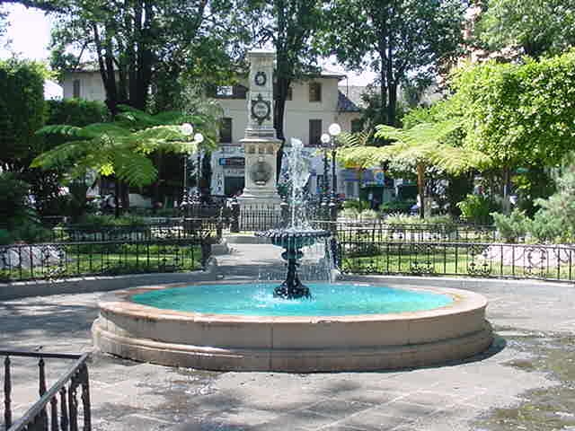
The départ for the day is the small Mentonasc town of Sospel, sitting in one of the many valleys on the route from Nice to Turin. No sooner have the riders reached kilometre zero than the road turns uphill. The first challenge of the day is actually one of the most climbed roads in the history of the Tour, although we haven't seen it in a long, long time now. The Col de Braus, long forgotten to the Tour, is a solid 11,2km at 5,7%, offering a challenging warmup to the riders as a threat of what's to come, and to allow fans and viewers to marvel at the road and the scenery on the way, plus also pay tribute to René Vietto, the second winner of the mountains classification of the Tour all the way back in 1934, whose tombstone is laid at the Col de Braus. However, rather than heading back down towards L'Escarène, the riders will continue uphill towards the Col de l'Ablé. Looking at that profile you will note the Col de Braus partway up; we are continuing to do this climb - the points will be awarded at Plan Constant, beneath the summit of the Cime de Grand Braus.

The first climb of the day over, the riders may be glad for a bit of a break. But they don't get much of one; only 5 kilometres later they reach the Pas de l'Escous, where the road turns uphill again to take them up the tangled roads to Baisse de la Cabanette. The route to our next mountain stopoff, the Col de Turini, looks rather like this, only missing a bit of the start of the climb as we are joining it at the Pas de l'Escous. The relatively low gradient provides a bit of respite for the riders, before they take on the highly technical descent into Roquebillière.

Next on the menu is the long drag up to the Col Saint Martin. The riders don't take on the first 4 kilometres of that profile, joining from the Turini descent at that point. Though this climb is never really steep - its steepest phase being just 7,5% - it is long and does not really let up, so though any decisive moves are unlikely, it will allow the stage to transition from the early climbs to the focal points of the stage. The views down into the valleys will remind the riders of how far they've come, and how far they must come again as well, as though we have reached 1500m, there's much, much more climbing to be done. The descent from the Colmiane station is easier than the one from Turini, but still challenging enough to make the riders think a bit on the way down to the intermediate sprint in the town of Saint-Sauveur-sur-Tinée shortly before the halfway point in the stage.

The next climb, however, is where the real trimming of the pack will take place. Probably the hardest climb of the day, the Col de la Couillole averages over 7%, and spends most of its time in that region, consistently putting in kilometres in the 7s and 8s, and occasionally 9s too. It has, perplexingly, only ever been used once in the Tour de France, all the way back in 1975, and that was in the opposite direction. Still, at least it was a great climber who topped it - Lucien van Impe is the first man across the col forevermore. The riders will also pass through the Gorge de Cians, perhaps the nearest thing that the Tour can offer to the incredible beauty of the Sottoguda Gorge on my beloved Passo Fedaia. Of course, it's not all as spectacular as the Gorge, but the rest of it is quite spectacular too. The scenery may distract from static racing; there are still 90km left to ride when the riders pass the summit of the Couillole, so while many a rider may go out the back, there may well not be any going off the front.

After Couillole, we have the short and transitional, two-stepped climb of the Col de Valberg to come. Much as Sourzay was just a little addendum to Errozate, Valberg is just a little addendum to Couillole, before the riders face a twisty but fairly gradual descent into Guillaumes with 61km to go. Now, the final climb of the day, and the longest too. After a short stint of false flat leading in, the Col de la Cayolle unleashes its fury on the riders. This long and difficult climb has only been used 3 times by the Tour - in 1950, 1955 and 1973; it has lain dormant since then. It announces itself after a short period of gradual climbing with a lengthy phase at 8%; a brief respite at 4-5% follows before it ramps up again to average well over 7% for its last 7km, with some steep ramps that can really serve as a launching pad for an attack, especially bearing in mind the twisty and sometimes dark path that the riders will be winding through the mountains. The road is cut into exposed hillside higher up, as the riders face steeper and steeper roads, and hopefully, act more and more aggressively as with so much climbing in the legs, surely the riders can find plenty of opportunities to make time on one another on climbs like these. The summit of this final climb of the day, separating Alpes-Maritimes and Alpes-de-Haute-Provence, comes with 29 kilometres still to go, but apart from a few steep, technical bits near the start of 
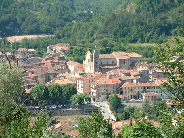
the descent it's fairly easy going and mostly very straight; not one where a superb technical descender can make huge gains, but a big powerful rider who has little fear going downhill can certainly build up a lead here, on the run in to Barcelonnette, the town in the Ubaye valley that serves as the stage town for today.

With the descent finish, one can imagine a breakaway taking it, but the stage has been designed with cumulative climbing in mind so as not to result in fairly timid racing such as that we saw in Jausiers in 2008, and instead try to ape the more successful Sainte-Jean-de-Maurienne stage from 2010. After all, I've done my best to make sure the climbers have the required motivation to animate things early on and break this thing to smithereens.

Sospel:
1dessus.jpg


Barcelonnette:
alpes-barcelonnette.jpg
 
craig1985 said:
History lesson aside, it's not that selective although the climb out of Apatzingán is not the hardest but has some steep sections but should end in a bunch sprint. The other big city located in Michoacán, Uruapan is also passed through in the route.

Worth noting however that since the riders are climbing from sea level to 2000m altitude and then staying at that, attrition will be a big factor, could well see half the bunch spewed out the back of the group by that like in Qinghai Lake.
 
May 6, 2009
8,522
1
0
Visit site
Libertine Seguros said:
Worth noting however that since the riders are climbing from sea level to 2000m altitude and then staying at that, attrition will be a big factor, could well see half the bunch spewed out the back of the group by that like in Qinghai Lake.

I do wonder what are the chances of cross and side winds to hit the chasing group as they try to get back on to the peloton.
 
May 6, 2009
8,522
1
0
Visit site
Stage 14 - Guadalajara - La Primavera (Guadalajara) 147km:

Map and Profile

We move to Guadalajara for stage 14 and the day before the second rest day of the Vuelta a Mexico. The stage 14 finishes in (Bosque) La Primavera outside of Guadalajara, La Primavera being a national forest, including MTB paths. Guadalajara, Mexico's 2nd largest city and also the capital of the state of Jalisco. Not surprisingly Guadalajara is named after the Spanish city in Castile-La Mancha (60km north of Madrid) with the name originating from the Arabic word wādi l-ḥijāra (واد الحجارة or وادي الحجارة) the literal translation of the Iberian name Arriaca, meaning "Valley of stones" (thanks, wiki). in English the city is known as the "City of Roses".

Guadalajara is also ideal to home a cycling race and they had recently experience in hosting the 2011 Pan American Games with Marc de Maar getting the victory in the road race, and Colombian veteran Marlon Pérez (formerly of Caisse d'Epargne, now on Colombia - Comcel) winning the time trial. Guadalajara is also home to three football teams - Chivas, Atlas and Estudiantes, with Rafael Márquez, Oswaldo Sánchez, Pavel Pardo, Andrés Guardado, and Mexico national Team's Top Scorer Jared Borgetti all coming from Atlas.

The stage starts in Tlaquepaque, and after 12km, the peloton is in the outer suburbs where IBM Mexico and Don Miguel Hidalgo y Costillo International Airport are located. Much of the stage is raced around La Primavera, with the climb starting after 117km, which will go for 8km where they enter La Primavera. Much of the climb isn't steep, but opportunistic riders will still have a go. The real selective bit is at 143km, where the riders have a short but steep sections that get to 20%, before a slight descent, before another climb that gets up to 14.5%, before the small descent to the finish.

Guadalajara:

blog_guadalajara1.jpg


La Primavera (Guadalajara):

laprimavera.jpg
 

TRENDING THREADS