• The Cycling News forum is looking to add some volunteer moderators with Red Rick's recent retirement. If you're interested in helping keep our discussions on track, send a direct message to @SHaines here on the forum, or use the Contact Us form to message the Community Team.

    In the meanwhile, please use the Report option if you see a post that doesn't fit within the forum rules.

    Thanks!

Race Design Thread

Page 59 - Get up to date with the latest news, scores & standings from the Cycling News Community.
If you guys want to take the responsibility of maintaining such a library of PCM posts, then I'll link it from page 1.

I'm liking Eritrea. A country with such a love for the sport ought to be rewarded. Some great scenery there, how much of the roadways are properly paved and road-bike territory? Or would there need to be some kind of 'cross-style mods in places? I know some people ride 'cross bikes at Roubaix, for example.
 
This is a race I've been working on for a while, trouble getting the mapping software to work so far north has been one bane (though of course it's not as far north as my GP of Tromsø!), the other is turning it into a reasonably realistic race in terms of organisation and logistics given the nature of the area in question.

I feel that I have, at least to an extent, solved these and can therefore proceed to introduce the Tour of Iceland. Or, given the linguistic purism of the Icelanders, Reiðtúr á Íslandi. For this Tour, we will spend the first half in the southwest, close to the main population centres, before spreading further afield. I will also explain the logistical procedures in terms of how equipment and riders come to be in the right places at the right time to compete.

Stage 1: Reykjavík - Reykjavík, 153km

35c3pqq.png


10xu820.png


Climbs:
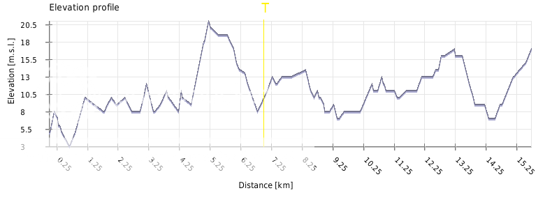
Perlan (3rd passage)(cat.3) 2,5km @ 1,8%
Perlan (8th passage)(cat.3) 2,5km @ 1,8%
Perlan (13th passage)(cat.3) 2,5km @ 1,8%

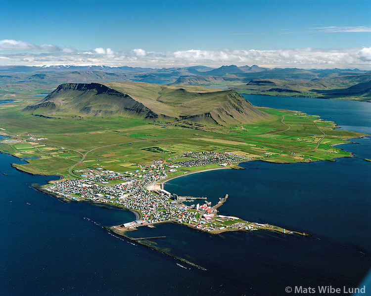
We start with a circuit race in the capital of the country, which will hopefully draw some attention to the race. Just under 40% of Iceland's population live in the capital and its outlying districts (and in the whole area some two thirds of the country's population), so this will probably be the best attended stage of the race.

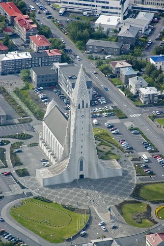
The stage consists of 15 laps of a 10,2km circuit which begins and ends at one of Iceland's major landmarks, the Hallgrímskirkja. From here, the riders will head southeast to the summit of the Öskjuhlíð hill, site of another landmark, the Perlan ("The Pearl"), a monument built on top of six water storage tanks atop the 61m high hill. As the ceiling of the stage, mountains points will be given out on three circuits despite the meagre statistics.

These statistics (2,5km @ 1,8%) aren't entirely accurate, however; they account for two separate climbs. The first, which comes before the finishing line, from Íslenska Operan to Hallgrímskirkja, is 700m at around 4,5-5%; there is then a bit of flat and descent before climbing from the Fridríkskapella to Öskjuhlíð, which is about 850m at 4,5%. Certainly not enough to trouble most sprinters, although 15 times around the circuit may manage to harm the likes of Furlan and Guardini, you never know. The "descent" takes us north again, past the City Theatre and the old University Campus, before turning left onto Laugavegur. This lightly cobbled street is Reykjavík's main shopping street - how do we know? Because it says so!

This is then swapped for the winds coming in on the coastal front of Sæbraut, nice wide open roads where the cameras can pick up the North Atlantic and the mountains in the background. Then the riders head inland for a series of corners encircling another Reykjavík sight, Tjörnin (aka "The Pond"), an inner-city man-made lake with Fríkirkjan Reykjavík on one side of it, and the City Hall built so that it is actually standing in the middle of the lake.

From here we turn back onto the other end of Laugavegur for only a few metres before turning right onto that final, uphill 700m described earlier, on Skólavörðustígur, with Hallgrímskirkja ominous in the riders' view. So, a pretty straightforward stage, a circuit race around the capital not to finish the race but to start it; and with this being the biggest city around, the riders can rest up and enjoy a bit of Reykjavík's famous nightlife.
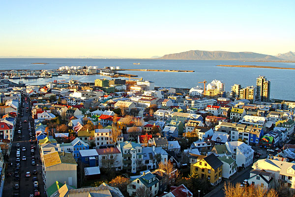
Reykjavík:
reykjavik-panorama-iceland.jpg


Hallgrímskirkja:
church-of-hallgrimur-reykjavik-isl110.jpg
 
Jul 2, 2012
343
0
0
Visit site
Pro Cycling Manager Race Versions

PCM 2011:
Giro d' Italia (Progsprach): http://www.mediafire.com/download.php?hhd7daagcautbnw
Tour of Beijing (Progsprach): http://www.mediafire.com/download.php?mtfa8ro94aipb1c
Velka cena Bradla (togo95): http://www.mediafire.com/?u2eqf7cz0p5tz52
Tour of 3 Islands (togo95): http://www.mediafire.com/?ttmbfz5en47dmnk
Tour of Slovakia (togo95): http://www.mediafire.com/?xho91j4fj4s7w47
Tour of Slovenia (togo95): http://www.mediafire.com/?ow7uzc1b1ezi4ee
Niedersachsenrundfahrt (Progsprach): http://www.mediafire.com/?qg5u17btv2qf49k
Vattenfall Cyclassics (Progsprach): http://www.mediafire.com/download.php?q7h22d26rfiuv8o
Wellington GP (Progsprach): http://www.mediafire.com/download.php?akefwx19ryykxqy
 
Jul 2, 2012
343
0
0
Visit site
Niedersachsenrundfahrt Stage 1

Harburg - Neu Wulmstorf ITT (16km)

Well, this was probably one of the worst stage races ever to be held, but since I live there I figured, I'd make something to do the Bundesland at least a bit more justice. We start this off by time trialling from just over the border of Hamburg into the eponymous state more specifically into the small town of Neu Wulmstorf with a time check in Hausbruch. The course is completely flat, but we have already created bigger time gaps than the original race.

Route:
route01-1.png

Profile:
profile01-2.png
 
Libertine Seguros said:
If you guys want to take the responsibility of maintaining such a library of PCM posts, then I'll link it from page 1.

I'm liking Eritrea. A country with such a love for the sport ought to be rewarded. Some great scenery there, how much of the roadways are properly paved and road-bike territory? Or would there need to be some kind of 'cross-style mods in places? I know some people ride 'cross bikes at Roubaix, for example.

They have been building roads a lot lately and almost all paved roads are new. Unfortunately they suffered a lot from the Ethiopean-Eritrean war, but main roads have been rapaired. Thus these are good quality. Information about number of asphalted roads vary between 800 and 14000 km :D (I would say it is somewhere around 2000 km).
From the roads I used are approximately 75% paved (stages 1, 2, 3, 7a are whole on paved roads), 15% good gravel roads, and 10% bumpy roads (would probably require bike change at the end of stages 4 and 6)
Stage 5 has only small amount of paved roads (55 km at the start) and it would be worth to complete whole stage on CX bike or on something between road and CX bike.

I'm looking forward to your Iceland tour. I've made one too, but I'm not satisfied with it so I wonder what did you devise ;)

Meanwhile I'm preparing Tour of Yemen and Olympic road race.
 
OG road race 2012

London - London; 244 km

Race starts on Piccadilly street and immediately heads out of London through Chelsea, Wimbledon and Chessington. At 40 km is located first passage of Box Hill. There are 5 laps around Box Hill, but different than in original road race, a bit shorter.
Then will riders go east with Shepherd's Hill, White Hill and Church Hill in Catterham en route to Warlingham, where begins main loop with 2 cliimbs. These are Succomb's Hill, short but very steep ascent, and Chalkpit Hill, longer and with some steep section as well. they will do this lap 4 times with 1 additional ascent of Succumb's Hill. From the top of this last climb it's 26 km to the finish in front of Westminster Palace.

Climbs:
Box Hill (41, 57, 72, 87, 103) - 3,4 km; 4,3%
Shepherd's Hill (121) - 1,4 km; 5,5% (with 400 meters at 10%)
White Hill (126) - 1 km; 8,5%
Church Hill (130) - 0,5 km; 11%
Succomb's Hill (133, 154, 175, 196, 217) - 0,6 km; 12,4% (maximum 25%)
Chalkpit Hill (147, 168, 189, 210) - 1,5 km; 9,5% (maximum 20%)

35lahs8.jpg


8wmfsg.jpg


Start:
2ius66b.jpg


Finish:
vmuno9.jpg
 
The Niedersachsen Rundfahrt?! ARGH! KILL IT!!! KILL IT WITH FIRE!!!!!!

Hopefully you can make it waaaaaaay better than the real thing was. Hard to make it worse, mind. Guess there'll be a tricky up-and-down stage around Osterode and Göttingen? The Olympic route looks way better than the real one, and if they get their way with their 160km race that's supposed to have the prestige of a Monument in a few years' time (lol) they would do well to look at this on the basis that that actually looks like a decent example of a parcours for a classic.

On the PCM thing:-
Do you guys want to decide amongst yourselves whose post to use and then edit links to each other's posts into it and have me just link the one post, or do you each want to keep going back to the same post of your own to add things in and have me link to each from the first page, thus necessitating another library post for me to link those from?
 
Sep 8, 2010
1,441
0
0
Visit site
Libertine Seguros said:
The Niedersachsen Rundfahrt?! ARGH! KILL IT!!! KILL IT WITH FIRE!!!!!!

Hopefully you can make it waaaaaaay better than the real thing was. Hard to make it worse, mind. Guess there'll be a tricky up-and-down stage around Osterode and Göttingen?

Really great final stage in 2005. St.Andreasberg is up to 18%, real killer. In the south, there are some good opportunities, thats right. Hoher Hagen, Göttinger Wald, Solling, Harz etc.

And in the North you can find some nasty cobbles. Looking forward to your course, Progsprach.
 
Yea, sorry, didn't mean to be so harsh. Not without it being clear it was humorously intended anyway, since I hated the real thing - will be interesting to see what it could have been if the organisers had been more creative.

I'll continue with my Arctic explorations...

Stage 2: Hafnarfjörður - Akranes, 154km

1zoyeiq.png


x5axs3.png


Climbs:
Elliðavatsnvegur (cat.3) 1,8km @ 4,5%
Eyrarfjallsvegur (cat.3) 2,4km @ 4,3%
Svarfhólsvegur (cat.3) 1,3km @ 5,0%

The second stage of the Tour of Iceland starts not far south of Reykjavík, in the third most populous city in the country, with circa 30,000 inhabitants, the southwestern port town of Hafnarfjörður. This town is the home of several of the country's popular musical acts, such as HAM, Botnleðja and Jakobínarína, but the péloton will have no time to appreciate the sounds, as they are almost immediately thrown up the first of three categorised climbs in today's stage, the short rise on Elliðavatsnvegur from the edges of Vífilsstaðavatn to the village of Kórar. After this we bypass Reykjavík by utilising the rolling terrain on its eastern side, and then return to the coast to enjoy the coastal roads alongside Kollafjörður. This then gives way to the attractive road along the Hvalfjörður. We could have taken the tunnel of the same name to go straight to our finishing town, but that would be a bit dull.

Instead, then, it's more roads with pretty views of fjords, sometimes dramatic too - superb for helicam! This is broken up by a short trip on the strade bianche-styled dirt road of Eyrarfjallsvegur, followed by a second short, more flat/rolling stretch on Meðalfellsvegur, before we return to the coastal roads, with better tarmac but similar rolling terrain. A third short climb, once more on dirt roads, breaks up the stage, but the rest of it's on pretty good tarmac, rolling down the dramatic landscape along Þjóðvegur (the ring road, that loops around the whole island - we'll be seeing a few parts of this this week!) before the finish, which will likely be a sprint, in the growing town of Akranes.

Hafnarfjörður:
hafnarfjordur-99-26285.jpg


Akranes:
Akranes-MWL-27-149-02-BF.jpg


After the stage the riders will drive back, through the tunnel, to Reykjavík for another comfortable night in the capital.
 
Jul 2, 2012
343
0
0
Visit site
Well, you will probably have to wait for the rest of the stages of this race and the alternative Cyclassics I'm almost finished with for about 3 days since I'm on a short vacation, but I did edit my earlier PCM post to include togo95s files so you can link that one.
 
Tour of Yemen - 5

Stage 5: Ahwar - Mukayris; 215 km

First GC relevant stage with 2 climbs. First 115 km are flat along the coast. Then comes first gradual climb and another flat. 'Aquabat Thirahis thesecondclimb and it's a beast. Only slightly shorter and less steep than
Zoncolan from Ovaro. The littleweight climbers will be a factor here. However you must have some energy left by the end of this climb, because stage doesn't end here. It's another 13 flat km till finish in Mukayris.

Climbs:
climb [#2] (138) - 18 km; 5% (contains 7,5 km long section with average 7,6%)
'Aquabat Thirah (202) - 9,7 km; 11,3% (has 34switchbacks)

2zg8zkh.jpg


sltoiq.jpg
 
Tour of Yemen - 7

Stage 7: Aden (Shaykh Uthman) - At Turbah; 174 km

This is the first of two mountain stages sheduled for the second weekend of the tour. This one is going to create time gaps no matter what due to extreme steepnes of the climbs located near finish of stage 7. Stage starts in Aden (in the town of Shaykh Uthman). First climb, Naquil Ibüh, begins on 110th km at elevation 950 meters. This indicates that the first 110 km aren't just flat, since the start is at the sea level.
The steep sections of first big climb of the day doesn't kick off too early, first half of Naquil Ibüh have average about 5,4%. At this point of the stage everyone will be looking at what lies in front of them, the switchbacks of Naquil Ibüh(in the number of 35). However no look can tell you how tough it is to ride up. You know, 15% is quite steep grade to ascend, but it is manageable, when it lasts for few hundred meters, but here riders have to climb this beast with almost 6 km and average slope 15%. When at the top, they won't have much time to enjoy this great views.
But this is only one out of three climbs this day. Naquil 'Uzayz doesn't have pralude like Naquil Ibüh. It is appalling from the biginning. And unlike Naquil Ibüh, Naquil 'Uzayz is gravel road (we can only hope, that weather will be better than on that picture). After short descent riders are going up again and it is Naquil Ibüh what lies in front of them. From the top of second ascent to Naquil Ibüh it's just 8,5 km of partly flat partly slight descentto At Turbah.

Climbs:
Naquil Ibüh (122, 171) - 12 km; 10% (there is a section of 5,5 km with 15% average :eek:)
Naquil 'Uzayz (152) - 4,1 km; 13,6%

2hcizhg.jpg


2zi95ic.jpg
 
Tour of Yemen - 8

Stage 8: Nayd an Nashamah - Jabal Sabir; 174 km

One more day till rest day and riders will be looking forward it. No rest waits for them on the second Sunday however. After start in Nayd an Nashamah they follow wide road to Ta'izz (the third largest city in Yemen with population of 600 000) and pass by Yufrus Monsque. They will be in Ta'izz and outskirts for about 35 km till the first big ascent of the day.
Jabal Saber is one long, but also quite steep climb and what's also important it has great tarmac. It's different than Naquil Ibüh, the gradient rarely goes above 12%, but that's his forte. It's so steady, but in high gradients, so weaker riders will be falling away like beads.
After off th eother side of the climb and 40 km of flat/rolling terrain, Jabal Saber comes on the menu once again. This time it's MTF (first and only one).

Climbs:
climb [#3] (13) 2 km; 9,2%
Jabal Saber (80) - 17,7 km; 9,1%
Jabal Saber (155) - 19 km; 8,8% (has around 55 switchbacks)

29p9llj.jpg


n54vbn.jpg
 
Stage 3: Selfoss - Grindavík, 164km

29ln66b.png


2zri6fr.png


Climbs:
Eldborgarhraun (cat.3) 3,6km @ 4,2%
Bláfjallavegur (cat.2) 5,8km @ 3,6%
Krisurvíkurvegur (cat.3) 1,0km @ 9,3%

The last part of the first section of the race is entirely in the southwest of the island, starting in the municipality of Álborg, the largest of those in the very south. Selfoss is a growing town, but also its main claim to fame is that it was the site of a fairly large earthquake in 2008. The riders' first task is the flat trek down to the coast at Eyrarbakki, before the first climb of the day up to the edge of Eldborgarhraun on Þrengslavegur. After a short period on highway 1, the riders head onto their first category 2 ascent, the mid-length, but still very gradual (<4%) rise of Bláfjallavegur, although we only do the first two thirds of this, as the road up to Bláfjöll ski resort is a dead end.

The riders then take a gradual downhill back towards sea level before they turn south onto Krisurvíkurvegur, which leads us to the lake at Kleifarvatn. There is a short, steep dig at one point as the road circumnavigates the water, then shortly after this there is another nice little challenge for the riders - while parts of the 42 may have been poorly tarmacked, sections of the 427 aren't paved at all! After about 10km of this troublesome terrain, the roads become paved again, allowing the riders to enjoy their views of the remarkable volcanic coastline without worrying so much about punctures... though they may be glad not to be breathing through their noses as they pass the Sulphur Springs on the way into Grindavík, today's stage town.

After arriving in Grindavík, the riders have three laps of a 16,5km circuit to handle. This is nothing more than rolling and shouldn't disrupt too many riders, though it means the run-in may not be ideally suited for sprinting trains. There are two main things to note on the circuit - firstly the geothermal energy station, but mostly the world famous Bláa Lonið, known to the outside world as the Blue Lagoon, one of Iceland's premier attractions, and perhaps somewhere for the riders to rest up after the stage's exertions, being just outside the finishing town! The finish is absolutely dead straight for the last couple of kilometres, so if the rolling hills didn't let anybody get too far ahead before then, then this is pure sprintsville - the terrain goes up and down a couple of times though, so trains may find it hard to assert themselves.

Selfoss:
selfoss-23133leik2.jpg


Grindavík:
grindavik-93-25459.jpg


After this the riders will transfer over to Keflavík, home to the country's main airport, where they will stay the night, while equipment will face a long evening's drive over the south side of the country ahead of tomorrow's race.
 
Tour of Yemen - 9

Stage 9: Ta'izz - Uzullah; 172 km

After rest day in Ta'izz comes another hard stage. Firstly it encircles Jabal Saber and then heads north towards Ibb. Top of the first climb of this stage is in some town, but I don't know what's its name. On the way to Ibb there is oldest mosque in Yemen by the road.
At 95 km into the stagebegins first big challenge of the day. First 15 km have average only just over 3% and are paved. But at this mark (10 km to the end of the climb) begins the suffering. It's now gravel road and the average gradient for theese 10 km rises to 8%. The forthcoming descent is quite dangerous since it's steep (about 11%) and still on unpaved road. Cyclists will be happy it's only 5,5 km long. Next climb is really steep, but short. The road here would probably need some work to be done on it, because it looks far from road-bike rideable road. Fortunately at the top finaly begins another section of asphalted road as they go through the town Jiblah. After 20 km of downhill riders will be under the city of Ibb. There begins final climb of the day, which avoids Ibb and goes up, to the mountainsabove this city. This climb top at 2675 m.a.s.l.
Finish in Uzullah is 9 km further and 300 meters lower. Just before finish riders will pass by old fortress Hesn Habb.

Climbs:
climb [#4] (34) - 6,6 km; 7,3%
climb [#5] (121) - 25,5 km; 5,1%
Jiblah (129) - 2,6 km; 12,5%
climb [#6] (163) - 15 km; 6,8%

xberuc.jpg


m9pu1c.jpg
 

TRENDING THREADS