• The Cycling News forum is looking to add some volunteer moderators with Red Rick's recent retirement. If you're interested in helping keep our discussions on track, send a direct message to @SHaines here on the forum, or use the Contact Us form to message the Community Team.

    In the meanwhile, please use the Report option if you see a post that doesn't fit within the forum rules.

    Thanks!

Your local weather

Page 53 - Get up to date with the latest news, scores & standings from the Cycling News Community.
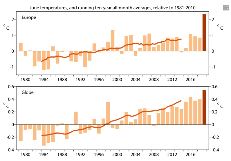
Here usually during heat waves is dry with dew points below 10°C and decent minimun temperatures around or below 20°C if not cloudy or windy, but this year we come from a 200+ mm May that ended with submerged fields and a lot of locally produced moist from evaporation in the first half of june then in the last two weeks with the high pressure costantly over western Europe we had winds blowing from NE that took humidity from the Adriatic sea and the Padanian hell (in Pianura Padana is terrible the summer due to humidity and also night heat forced by urbanization and heat islands) so in the end since the beginning of the month only three days the dew point was below 15°C and in a lot of cases was around 20°C with the exceptional peak of 24°C two days ago.

Situations with high humidity and dew points over 20°C are instead very common when there is perturbed weather and rain because nowadays cool breaks have become very rare during the summer with the warming trend of recent decades, during 2014 summer when there was rain almost every day was terrible in that regard, i don't like heat in general but i prefer to have 40°C with 10% of humidity rather than 28°C with 80% and rain.

Anyway the next days should be better, yesterday evening the wind stopped and we lost a dozen of degrees in dew point (now is 11°C) and this morning the minimun temperature was below 20°C (yesterday was 25,4°C, one of the highest since i record weather data at my home), the next "problematic" day should be the 3rd of july when there is risk of rain with 850 hPa temperatures still around 20°C so pontentially a sauna day.
 
June over Europe has been over 1°C warmer than the previous (1999) hottest june on record.

giugno2019_globale.png
 
Tomorrow here there will be the first real cool break since the end of may, even if will be something really fast (only tomorrow is expected a maximum temperature below the average), the effects after so much warm accumulation risks to be destructive with up to 350 mm forecasted over the Arcipelago, something unbelievable considering that some islands like Pianosa usually have only 250/300 mm of rain per year.

ureVl9Y.png
 
On Wednesday and Thursday the 40°C limit has been surpassed for the first time in both Belgium and Nederlands, in France first time over 40°C in Dunquerke in the extreme northeast of the country and Paris Saint Maur with 43,6°C has set a record incredible for Western Europe at almost 50 degree north of latitude, a lot of cities in Italy and Spain around 45 but also some around 40 degree north of latitude have lowest record.
 
It's been really good in Scotland for a few years now in my experience. Changes in global temperatures appear to mean that we get the wet, warm and windy weather of the gulf stream (from the west) less frequently, and instead get calmer, drier weather systems from the north, east and south more often. Still enough wind to power the country unaided and still plenty rain from time to time, but everything's relative.

Plants in my garden have been dying, even in winter, due to a lack of moisture. Which is unprecedented. Give it ten years and maybe even the midges will feel the pinch.

I attribute it to the collective idiocy of humanity, but Scotland is one of the few (only?) places where it is improving things. 32 degrees celsius last week remains extremely unusual and we dont get the longer heatwaves that the nordic countries seem to now be getting at similar latitudes (?)
 
Re:

Fergoose said:
It's been really good in Scotland for a few years now in my experience. Changes in global temperatures appear to mean that we get the wet, warm and windy weather of the gulf stream (from the west) less frequently, and instead get calmer, drier weather systems from the north, east and south more often. Still enough wind to power the country unaided and still plenty rain from time to time, but everything's relative.

Plants in my garden have been dying, even in winter, due to a lack of moisture. Which is unprecedented. Give it ten years and maybe even the midges will feel the pinch.

I attribute it to the collective idiocy of humanity, but Scotland is one of the few (only?) places where it is improving things. 32 degrees celsius last week remains extremely unusual and we dont get the longer heatwaves that the nordic countries seem to now be getting at similar latitudes (?)
Here temperature wise it's like being in some Mediterranean island close to Africa like Sicily, Malta, Creta during the summer in recent years, in the 1961-1990 CLINO June had a monthly mean maximum of +26,5°C, the average of last decade (2001-2010) was already +30,5°C and in this decade we had already seven June over 31°C with the other two at +29,8°C and +28,7°C, July and August were around 30°C (+30,3°C and +29,6°C) in the 1961-1990 CLINO, jumped to +32,6°C and +33,2°C in the last decade and in recent years is rare to have one below 34°C. Now you can even have May and September warmer than how were July and August.
But the worst thing is that the cool breaks have almost totally disappeared, in the past you could have days with less than 20°C of maximum, now you can count using one hand the days you go below 30°C (this year only two since the 7th of June) and when comes the rain it's like being in the tropics with crazy dew points.
The only thing that I save of the "new" summer is that under heat waves is generally dry and during the night the temperatures often falls to decent levels when the sky is clear, indeed the monthly average of minimum temperatures unlike the maximum have warmed less than one degree, the raise of the minimum temperatures is more a fall/winter problem when we are constantly under the Atlantic westerlies.
 
August is (almost) done and here we still have only two days with a maximun temperatrure below 30°C since the 7th of june and despite not having a real heat wave for the entire month the persistence of the high pressure has been enough to have again a monthly mean of the maximum temperatures around 35°C.
If the first two thirds of the month has been not so bad (feeling wise) because the heat was still dry in the last 7/10 days has been a sufferfest with convective thunderstorms every single afternoon and dew points constantly above 20°C.
 
Well we have a hurricane headed this way. It appears to have started to turn so it's not going to make landfall in Florida. The turn appears to have it possibly make landfall in South Carolina or possibly just stay off the coast. Either way we'll be getting rain and wind from it. As long as it goes through in one day we should (yes should) be alright. The biggest issue with the one here last year was it made landfall here (the eye about an hour and a half north of here) and just stayed here dumping rain for like 3 days and flooding everything. Oh and the area has not fully recovered from that hurricane. Due to where it's coming from it can't make a direct hit here due to the way the coastline is. In the latest forecast it appears that this coming week (Thursday) it will make a glancing blow including a brief landfall in the county north of where I live. The very good news is that it appears to be a fast moving storm and will be gone within 24 hours of when it shows up here. Hopefully the forecasts are correct that the winds will be at 110mph or lower. Of course two years in a row a hurricane during the middle of la Vuelta.
 
Last edited:
Well we have a hurricane headed this way. It appears to have started to turn so it's not going to make landfall in Florida. The turn appears to have it possibly make landfall in South Carolina or possibly just stay off the coast. Either way we'll be getting rain and wind from it. As long as it goes through in one day we should (yes should) be alright. The biggest issue with the one here last year was it made landfall here (the eye about an hour and a half north of here) and just stayed here dumping rain for like 3 days and flooding everything. Oh and the area has not fully recovered from that hurricane. Due to where it's coming from it can't make a direct hit here due to the way the coastline is. In the latest forecast it appears that this coming week (Thursday) it will make a glancing blow including a brief landfall in the county north of where I live. The very good news is that it appears to be a fast moving storm and will be gone within 24 hours of when it shows up here. Hopefully the forecasts are correct that the winds will be at 110mph or lower. Of course two years in a row a hurricane during the middle of la Vuelta.

I've been keeping an eye on Hurricane Dorian over the past few days, the pictures from the Bahamas right now look very scary with the 150mps winds. Hopefully all in Florida are ok and the same when it makes its way North towards Georgia and the Carolinas.
 
  • Like
Reactions: Koronin
It appears the latest update has Dorian staying just off the coast and coming through here as a weak Cat 2 or strong Cat 1. I'll take that with it in and gone within 24 hours. Fingers crossed it weakens more than that and that does stay off the coast. Storm surge where I live isn't an issue (I'm about 30 minutes inland), and our street didn't flood during last year's hurricane. My plan as of right now, is I'm staying here.
 
  • Like
Reactions: dusty red roads
East county San Diego has black skies, light showers and lighting ..still high 70's to low 80's for temperature. We have had great weather for the summer.
My thoughts are with the people getting pounded by Dorian..from the coverage I have seen there is total devastation..
 
Unusual thunderstorm here in Eugene... lots of lightning and thunder, but barely any rain.

While I would like to advise with my fave meteorologist as to what these kind of clouds actually mean, I just advised all of my dearest and nearest to stay inside.

Eastside wind coming in, currently, so I suppose all of these clouds will be blown your way, eastsiders.
 

TRENDING THREADS