- Oct 14, 2017
- 12,196
- 3,232
- 23,180
June is going to be wetter than our yearly total.
No kidding. Plus hurricane season just started. We need to dry out before any of those decide to show up.

June is going to be wetter than our yearly total.
Where are you exactly?June is going to be wetter than our yearly total.
Where are you exactly?
I study climate change impacts. Last year, we started an experiment looking into effects of more persistent weather. The trend for dry periods to be longer but also wet periods to be more persistent when they occur, has only been emerging recently. Basically, you're getting less average weather, and more situations where the atmosphere is 'stuck' in one mode.
After the wettest February ever recorded here in Belgium, we basically got almost no rain for nearly 3 months (mid-March until early June). These patterns are becoming clearer and clearer in many mid-latitude regions, probably caused by decreasing temperature differences between the arctic (climate warming goes faster there because of all sorts of positive feedbacks) and the equator, leading to a wavier jet stream with blocking highs. There are likely other factors at play regionally as well.
Fascinating stuff, weather and climate.
Boise Idaho USA. We had a dryish winter, dry spring and so far wet June. Its one thing to be rainy, but the obvious crazy part is the amount that falls per hour. There are no sprinkles, its torrential.Where are you exactly?
I study climate change impacts. Last year, we started an experiment looking into effects of more persistent weather. The trend for dry periods to be longer but also wet periods to be more persistent when they occur, has only been emerging recently. Basically, you're getting less average weather, and more situations where the atmosphere is 'stuck' in one mode.
After the wettest February ever recorded here in Belgium, we basically got almost no rain for nearly 3 months (mid-March until early June). These patterns are becoming clearer and clearer in many mid-latitude regions, probably caused by decreasing temperature differences between the arctic (climate warming goes faster there because of all sorts of positive feedbacks) and the equator, leading to a wavier jet stream with blocking highs. There are likely other factors at play regionally as well.
Fascinating stuff, weather and climate.
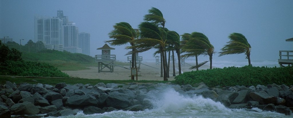
I hope that you are still good! The news footage looks awful!We survived with tree branches down, some fence damage and it appears my tomato plants didn't make it. Also lost power last night. Got it restored about 12 hours later. It is NOT fun being in the eastern eye wall of a hurricane. Those are the winds that knocked out power for basically the entire county I live in.
I hope that you are still good! The news footage looks awful!


Don't know about dry and wet periods being longer, but I do know that hurricanes are getting stronger and larger.
You do know? Compared to when? Is this based upon feelings, news reports or actual data? My understanding is actual data shows tropical storm frequency and severity for the globe is not increasing and in fact has fallen slightly. But if you read a little into the science this makes sense. The IPCC predicts the poles will heat faster than the tropics. If this occurs then the atmospheric pressure differential will fall and therefore wind speeds will reduce as the poles warm faster than the tropics.
The science also says climate change is making the world wetter overall even if drought may be experienced in some regions.
The climate models have a built in assumption that warming from CO2 will be magnified by feedbacks from water vapor trapping heat in the upper troposphere. This increased humidity will increase rainfall overall even if drought is experienced in some regions. The warming effect for a doubling of atmospheric CO2 concentration by the year 2100 is only 1.1C - source IPCC. The rest predicted is due to the assumed warming of these humidity feedbacks.
I know this is gonna seem like nothing after Koronin's woes, but... it's so hoooooooooooooooooooooooooooooooooooot!
I know, 28 Celsius (82 Fahrenheit) isn't much compared to some places, but I wasn't built for this heat.
Actually, global data suggests otherwise. Perception and reality.Like the severity of hurricanes that have been hitting the US over the past several years.
Actually, global data suggests otherwise. Perception and reality.
 www.sciencealert.com
Yes the Atlantic ACEs confirm this. However, Eastern Pacific ACE's show only 4 of the 14 years since 2006 were above normal. 4 years in this period were below normal ACE. Easily Googled. So the linked story is only right for part of the globe.2005 4 hurricanes hit the US. 2017 4 hurricanes hit the US 2020 will have a minimum of 3, which will include two hitting very likely on the same day. We aren't close to being done with hurricane season yet.
40 Years of Data Confirm Hurricanes Are Getting Stronger. Climate Models Were Right
The most powerful storms on our planet have grown substantially stronger, and almost forty years' worth of hurricane satellite imagery suggest a warming planet might be fuelling the changes.

Long-term data show hurricanes are getting stronger
In almost every region of the world where hurricanes form, their maximum sustained winds are getting stronger. That is according to a new study involving an analysis of nearly 40 years of hurricane satellite imagery.www.sciencedaily.com
Yes the Atlantic ACEs confirm this. However, Eastern Pacific ACE's show only 4 of the 14 years since 2006 were above normal. 4 years in this period were below normal ACE. Easily Googled. So the linked story is only right for part of the globe.
Like the severity of hurricanes that have been hitting the US over the past several years.
You are talking about the US. I am talking global. Climate models try to predict global trends.So you don't disagree with this:
They are more powerful. Thus proving that perception of those of us who live in the eastern seaboard of the US ARE experiencing more powerful hurricanes.
You are talking about the US. I am talking global. Climate models try to predict global trends.
That's fine. I just wanted you to be aware of the global research. You might also like to think about the story you quoted which claimed the data in the Atlantic proves what the climate models predicted. Yes it does in the Atlantic. But not the globe. Anyhow, this thread is about weather, not climate so we should be mindful.I've always been talking about hurricanes hitting the US's eastern seaboard. Those ARE stronger. Date proves they are stronger.
That's fine. I just wanted you to be aware of the global research. You might also like to think about the story you quoted which claimed the data in the Atlantic proves what the climate models predicted. Yes it does in the Atlantic. But not the globe. Anyhow, this thread is about weather, not climate so we should be mindful.
Good luck. In Australia where I live I am in no direct danger from tropical cyclones which only threaten our relatively unpopulated tropical north. But in America's populated regions you cop some worrying weather.True and hurricanes are definitely part of the weather where I live. Isaias just went through here a few weeks ago causing a lot of damage. Now it appears the path of Laura once it hits in the gulf will come up this way and we could very well get rain from it.
Good luck. In Australia where I live I am in no direct danger from tropical cyclones which only threaten our relatively unpopulated tropical north. But in America's populated regions you cop some worrying weather.
Whilst hurricanes are bad I find your tornados truly terrifying. In April 2011 I was in Minnesota in for a business trip during the so called "super outbreak". We were out one evening and noticed flashes of lightening in the distance but didn't think anything of it. But next day there were news reports advising three people lost their lives in a Tornado just 30 miles from where we were! Next day a huge storm passed overhead when I was in my room. I watched it from my window. The hotel lobby even called my room to advise I could move to the lobby if I felt safer there. I don't know how people can live with the possible threat of these things! What makes this worse is these things can come in the night when you are sleeping!


