- Feb 20, 2012
- 55,410
- 46,715
- 28,180
Broth3r said:Not that Portugal doesn't have its fair share of towns with unfortunate names, but... Pozo de las Mujeres Muertas? Guess they have us beat.
What does it mean?

Broth3r said:Not that Portugal doesn't have its fair share of towns with unfortunate names, but... Pozo de las Mujeres Muertas? Guess they have us beat.
Red Rick said:What does it mean?
Nilsson said:It means 'The Well of the Dead Women' or Dead Women's well. There are a lot of villages with very very odd names in Spain.


Libertine Seguros said:Oops, my mistake. Here's the link in full.
As for Fuente Escondida, I don't believe that's paved at present. Here's a picture.
I know I included a couple of unpaved or partially unpaved climbs (Sahún, Trobaniello), but they had a side paved or a project to pave them ongoing and were in condition better for putting a race on than this one is, unfortunately, as 24km at 7,5% will be a killer if they ever do pave it.
I also really wish they'd pave the connecting route between Salto de la Cabra and El Jito d'Escarandi.

Broth3r said:Aw, I held some hope for Torre. Guess that would have been too much of a cliché coming from a Portuguese :/
Of course, Sierra Nevada is a much more deserving finisher. Though you know, we give Guillén this reputation of a one-climb special lover, would-Zomegnan-include-this-insane-climb kind of guy... but at the end of the day, if that was really true, how could there be any financial or political pressure in the world able to stop him from pursuit that magic number of 3100m?
3100. It's magic, it resonates in your ears, it's brilliant.
As you said yourself in the Coll de la Gallina description, it wasn't mandatory that it had to be in Spain itself, and money is really the only thing that keeps the Vuelta from coming over the border, there's no practical issue whatsoever.Libertine Seguros said:I nearly included Torre in my honorable mentions. However, it's not in Spain and Portugal doesn't host the race nearly as often as Andorra, hence the mention for Coll de la Gallina. If they were to go over there though, Torre is a sure-thing ESP though. And I would still love to see it.
thanksLibertine Seguros said:Of those mentioned in this thread:
Climbs that can be used as a pass in more than one direction:
Haza del Lino (north is only a cat.1 climb, but both southern sides are ESP)
Coll de Pradell (west is only a cat.2 climb)
Alto de la Marta (south is only a cat.2 climb, north is ESP)
Fonte da Cova (west is ESP, east is cat.1)
Monte Oiz
Llano de las Ovejas
Alto de La Bobía (there are 15 sides, so multiple options)
Collfred (east is ESP, west is prob. cat.2)
Puerto del Escúllar
Santuário del Acebo
Coll de la Gallina (not when this was posted, but now that the Andorrans have fully paved both sides)
Climbs that can be used as a pass but only in one direction:
Collado de Sahún (ongoing paving project)
Alto de Trobaniello
Puerto de Vegarada (and it's debatable it's passable from that one!)
Picón Blanco (south side is the tougher climb but part of north side unpaved)
Climbs that are passable as passes but not at the very summit:
Picón del Fraile (passable at cat.1 Portillo de Lunada)
Pico Villuercas (passable at Collado de Ballesteros, viable same categorisation)
Turó de l'Home (passable at Coll de Santa Helena, cat.1)
Alto del Gamoniteiro (passable at Alto de la Cobertoria)
Alto de Ortzanzurieta (passable at Puerto de Ibañeta, cat.1 from north but only cat.3 from south)
Pico de los Reales (passable at Peñas Blancas, cat.1 in 2013 Vuelta)
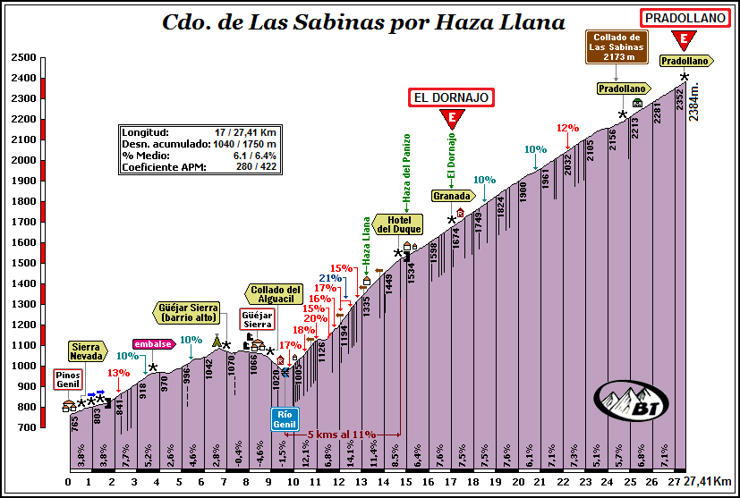
Sierra Nevada (passable at El Purche, El Dornajo, Collado de las Sabinas and Cruce Pradollano - beyond this it's a one-way)
Climbs not able to be used as passes:
Puerto de la Cubilla
Coll de Pal
Mont Caro
Peña Escrita
Jito de Escarandí
Salto de la Cabra (it is rumoured these two will be connected but I don't hold out much hope)
Collado del Algüacil
Presa de LLauset
Alto de Onsolár
Sierra de Carrascoy
Cap del Rec
Higa de Monreal
Libertine Seguros said:Of those mentioned in this thread:
Climbs that can be used as a pass in more than one direction:
Haza del Lino (north is only a cat.1 climb, but both southern sides are ESP)
Coll de Pradell (west is only a cat.2 climb)
Alto de la Marta (south is only a cat.2 climb, north is ESP)
Fonte da Cova (west is ESP, east is cat.1)
Monte Oiz
Llano de las Ovejas
Alto de La Bobía (there are 15 sides, so multiple options)
Collfred (east is ESP, west is prob. cat.2)
Puerto del Escúllar
Santuário del Acebo
Coll de la Gallina (not when this was posted, but now that the Andorrans have fully paved both sides)
Climbs that can be used as a pass but only in one direction:
Collado de Sahún (ongoing paving project)
Alto de Trobaniello
Puerto de Vegarada (and it's debatable it's passable from that one!)
Picón Blanco (south side is the tougher climb but part of north side unpaved)
Climbs that are passable as passes but not at the very summit:
Picón del Fraile (passable at cat.1 Portillo de Lunada)
Pico Villuercas (passable at Collado de Ballesteros, viable same categorisation)
Turó de l'Home (passable at Coll de Santa Helena, cat.1)
Alto del Gamoniteiro (passable at Alto de la Cobertoria)
Alto de Ortzanzurieta (passable at Puerto de Ibañeta, cat.1 from north but only cat.3 from south)
Pico de los Reales (passable at Peñas Blancas, cat.1 in 2013 Vuelta)
Sierra Nevada (passable at El Purche, El Dornajo, Collado de las Sabinas and Cruce Pradollano - beyond this it's a one-way)
Climbs not able to be used as passes:
Puerto de la Cubilla
Coll de Pal
Mont Caro
Peña Escrita
Jito de Escarandí
Salto de la Cabra (it is rumoured these two will be connected but I don't hold out much hope)
Collado del Algüacil
Presa de LLauset
Alto de Onsolár
Sierra de Carrascoy
Cap del Rec
Higa de Monreal
Because it's in a National Park and access to motor vehicles is restricted after Hoya de la Mora (2510m) to the service vehicles of the Park, the Radiotelescope and the Ski station.staubsauger said:If the Giro can do a gravel road mtt up to the Kronplatz, why can't the Vuelta do a mtt from Granada up to posiciones del Veleta!?


