
21 HC climbs the Tour should (re)visit
Page 10 - Get up to date with the latest news, scores & standings from the Cycling News Community.
You are using an out of date browser. It may not display this or other websites correctly.
You should upgrade or use an alternative browser.
You should upgrade or use an alternative browser.

- Mar 24, 2011
- 10,527
- 1,927
- 25,680
There's tons of La Rochette in France.Eshnar said:nvm, now I got it. Starts from La Rochette (2nd chance)
- Mar 24, 2011
- 10,527
- 1,927
- 25,680
- Mar 24, 2011
- 10,527
- 1,927
- 25,680

- Feb 20, 2010
- 33,267
- 15,817
- 28,180
Val Pelouse has pretty much nothing at the summit though, although the car park has got bigger fairly recently.
As a reminder, there's also a big space of grass up the road. I remember they are parking several cars on grass for some MTFs (Plateau de Beille, Mende...), as long as there is the room for it.Libertine Seguros said:Val Pelouse has pretty much nothing at the summit though, although the car park has got bigger fairly recently.
There's much more room at the summit of the next climb in the list than in places like Refuge de l'Abérouat, for example.
- Feb 20, 2010
- 33,267
- 15,817
- 28,180
I know, but I don't realistically expect L'Abérouat for that reason, even if Zomegnan might approve.
Last saturday, Thierry Gouvenou (who works at ASO) told to a webradio that the logistics for the Tour de France were 3 to 4 times bigger than the Giro or the Vuelta (the advertising Caravane, more media coverage, more security cars, etc.). That's why they cannot do MTFs everywhere, and they cannot go in some unpopulated places. He told that the southern Alps (between Nice and Barcelonnette) were "avoided" (he didn't say that clearly, but he was implying that) because there isn't enough hotels to welcome over 5,000 people without having to do too much driving. Let's take Isola as an example. It needs 1h30 of driving (for a car) to go either to Barcelonnette, Nice, or even Cuneo. For a bus or a truck, it can be over 2 hours... And it's on roads that are the exact opposite of flat and straight.Libertine Seguros said:I know, but I don't realistically expect L'Abérouat for that reason, even if Zomegnan might approve.
Even if Christian Prudhomme said that even if the logistics shouldn't have an influence on the route, it cannot be ignored.
#18: Val Pelouse (Isère)
The ghost station
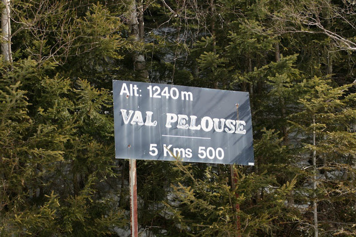
Sometimes, doing a project with a great ambition doesn't go well. Sometimes, they end up in a failure, and leave a blank somewhere. That's what happened to Val Pelouse. In 1969, this small winter sports station was established above Arvillard, on the "Grande Montagne", hoping that this station would become another success story in the Belledonne mountains like Les 7 Laux or Super Collet. However, after some years being viable, the station quickly started to lose money, as the frequentation was too irregular. In 1985, Val Pelouse was filed for bankruptcy, and the next year, the ski resort closed its doors, leaving only behind it a parking lot and the road to go to it.
If this station doesn't exist anymore, the name is still present. And in the recent years, some people found that this road, that only leads to a parking lot and some wild grass space, could actually be another beast to beat for the cycling riders. Something that is actually harder than the legendary 21 hairpins of l'Alpe d'Huez. Being 3 kilometers longer and a little bit steeper, the Val Pelouse climb could have been a legend back in the days. However, the station started to decline economically when the interest of doing stage finishes in winter sports stations was going back up. And Val Pelouse was just a small station, not a giant one like l'Alpe.
So what could motivate ASO to bring the Tour de France, or even a smaller race like the Dauphiné, up the Grande Montagne d'Arvillard, and what was called 27 years ago? Well, pretty much this.
Top: 1728 m
Length: 16.4 km
Ascent: 1373 m
Average gradient: 8.4 %
Climbbybike difficulty score: 155
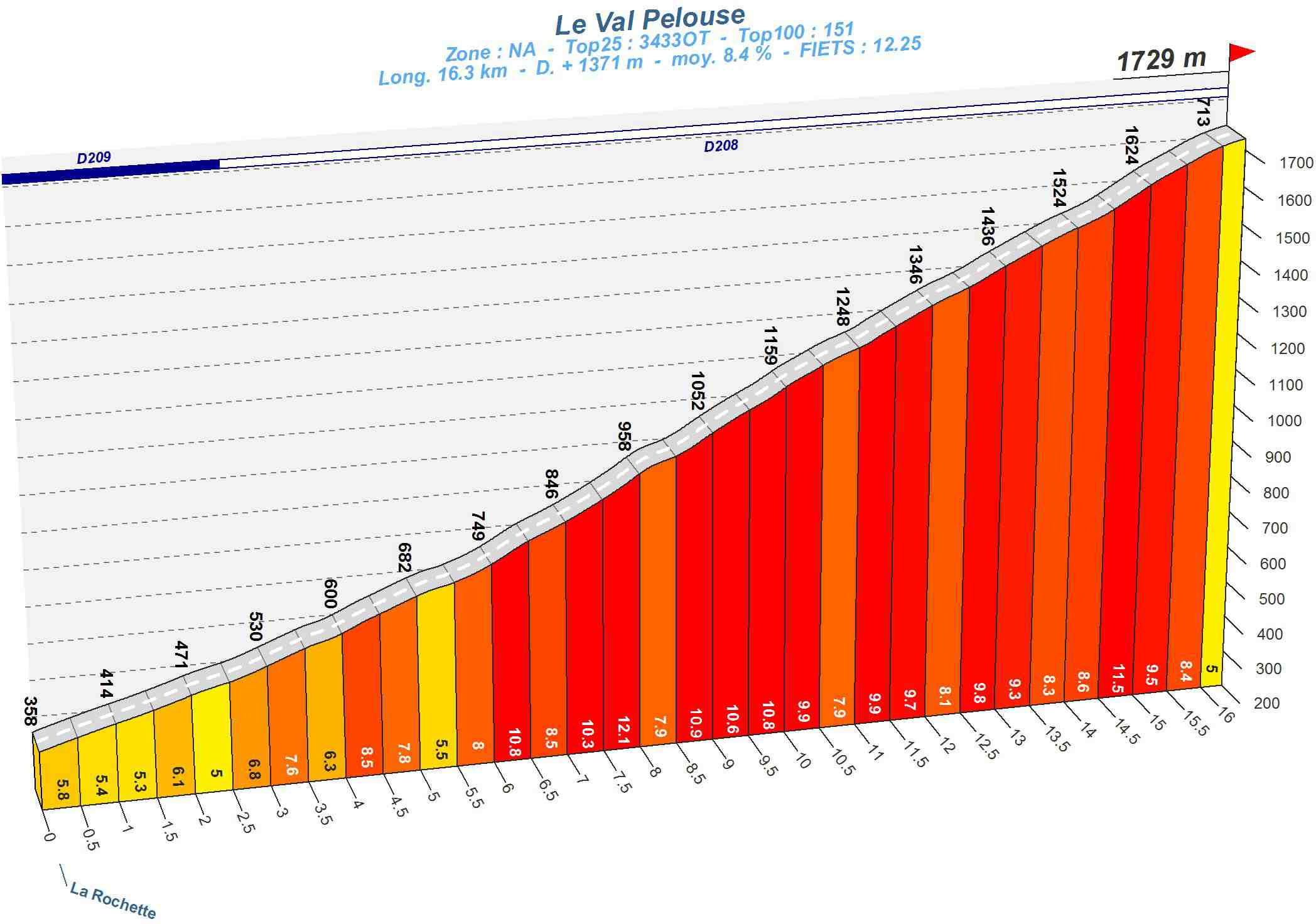
"Brutal" is probably the best word to describe this. After a rather easy start from the village of La Rochette, with a 6 % average during the first 6 kilometers, after Arvillard, everything starts to get harder to a point that is quite hard to find somewhere else in France. The final 10 kilometers never, and I say never, go below 9 % of average gradient, with 2 kilometers above 10 % and some 13 % parts. It just goes up, up, up, and it feels live never stopping. And the worst thing of them all is there's nothing at the summit to congratulate you, except just a parking lot. No black sign with the name of the climb and its altitude. No bar to celebrate. Just the "ruins" of a ghost station that existed 30 years ago, and was lost into history.
The departmental equipment probably didn't realize, when they made this climb, that it was one of the hardest in France. They just did the road through the forest, while keeping a degree of steepness that was acceptable for most cars. But it then became a local attraction after the station's closure for all the cycling folks that were in search of a new difficulty to climb. Its near-perfect regularity, combined with its length and high average gradients, make it a challenge that you can only find on the greatest climbs in France, like the Ventoux, or the Tourmalet. And if ASO thinks there's not enough room at the top, they can still do the Vuelta way by placing the finish two or three kilometers before the summit... Or taking the "easy way out" by doing a MTF at the Collet d'Allevard. Which is also an HC-worthy climb. But I wanted to put this climb just because it's much harder than the latter.


The ghost station
Sometimes, doing a project with a great ambition doesn't go well. Sometimes, they end up in a failure, and leave a blank somewhere. That's what happened to Val Pelouse. In 1969, this small winter sports station was established above Arvillard, on the "Grande Montagne", hoping that this station would become another success story in the Belledonne mountains like Les 7 Laux or Super Collet. However, after some years being viable, the station quickly started to lose money, as the frequentation was too irregular. In 1985, Val Pelouse was filed for bankruptcy, and the next year, the ski resort closed its doors, leaving only behind it a parking lot and the road to go to it.
If this station doesn't exist anymore, the name is still present. And in the recent years, some people found that this road, that only leads to a parking lot and some wild grass space, could actually be another beast to beat for the cycling riders. Something that is actually harder than the legendary 21 hairpins of l'Alpe d'Huez. Being 3 kilometers longer and a little bit steeper, the Val Pelouse climb could have been a legend back in the days. However, the station started to decline economically when the interest of doing stage finishes in winter sports stations was going back up. And Val Pelouse was just a small station, not a giant one like l'Alpe.
So what could motivate ASO to bring the Tour de France, or even a smaller race like the Dauphiné, up the Grande Montagne d'Arvillard, and what was called 27 years ago? Well, pretty much this.
Top: 1728 m
Length: 16.4 km
Ascent: 1373 m
Average gradient: 8.4 %
Climbbybike difficulty score: 155
"Brutal" is probably the best word to describe this. After a rather easy start from the village of La Rochette, with a 6 % average during the first 6 kilometers, after Arvillard, everything starts to get harder to a point that is quite hard to find somewhere else in France. The final 10 kilometers never, and I say never, go below 9 % of average gradient, with 2 kilometers above 10 % and some 13 % parts. It just goes up, up, up, and it feels live never stopping. And the worst thing of them all is there's nothing at the summit to congratulate you, except just a parking lot. No black sign with the name of the climb and its altitude. No bar to celebrate. Just the "ruins" of a ghost station that existed 30 years ago, and was lost into history.
The departmental equipment probably didn't realize, when they made this climb, that it was one of the hardest in France. They just did the road through the forest, while keeping a degree of steepness that was acceptable for most cars. But it then became a local attraction after the station's closure for all the cycling folks that were in search of a new difficulty to climb. Its near-perfect regularity, combined with its length and high average gradients, make it a challenge that you can only find on the greatest climbs in France, like the Ventoux, or the Tourmalet. And if ASO thinks there's not enough room at the top, they can still do the Vuelta way by placing the finish two or three kilometers before the summit... Or taking the "easy way out" by doing a MTF at the Collet d'Allevard. Which is also an HC-worthy climb. But I wanted to put this climb just because it's much harder than the latter.
- Jun 7, 2010
- 19,196
- 3,092
- 28,180
I see that Auron is holding the French MTB championships this year.
Seems big enough, but probably not for 5000 people
http://en.wikipedia.org/wiki/File:General_view_of_Auron_village.JPG
Seems big enough, but probably not for 5000 people
http://en.wikipedia.org/wiki/File:General_view_of_Auron_village.JPG
Usually, where the stage finishes isn't where all the logistics is sleeping. They tend to go in nearby cities.roundabout said:I see that Auron is holding the French MTB championships this year.
Seems big enough, but probably not for 5000 people
http://en.wikipedia.org/wiki/File:General_view_of_Auron_village.JPG
I mean, all 5000 people do not sleep at the Plateau de Beille, they go back into the valley and sleep in nearby cities like Ax-les-Thermes, Tarascon-sur-Ariège, or Foix. It also depends of the stage departure of the next day.
But I think the Tour need to park around 400 to 500 cars and some trucks for a stage finish (including all the finish buildings, the podium, antidoping controls, etc.). Not sure of the real number though.
- Jun 7, 2010
- 19,196
- 3,092
- 28,180
No, I mean it has probably the most hotel rooms in the immediate area and it's not a two hut resort. But it is still not big enough, I guess.
And I would have the race finish at Isola 2000.
And I would have the race finish at Isola 2000.
- Feb 20, 2010
- 33,267
- 15,817
- 28,180
After Bonette, an MTF at Auron would actually be great, because it's only about a cat.2 climb, so riders would need to attack on Bonette to make major gaps. You could do Izoard-Vars-Bonette-Auron. That would be great.
I asked Angelo Zomegnan what he suggested, and he cheated a bit by using Italy, but as he pointed out, he knows Italy better. Between the two of us we worked out a 230km stage from Guillestre to Auron, the last 200km of which are shown here.

That is, in order: Agnel (HC), Sampeyre (HC), Fauniera (HC), Lombarde (HC), Auron (2).
I asked Angelo Zomegnan what he suggested, and he cheated a bit by using Italy, but as he pointed out, he knows Italy better. Between the two of us we worked out a 230km stage from Guillestre to Auron, the last 200km of which are shown here.
That is, in order: Agnel (HC), Sampeyre (HC), Fauniera (HC), Lombarde (HC), Auron (2).
#19: Plateau de Solaison (Haute-Savoie)
The Bornes' secret
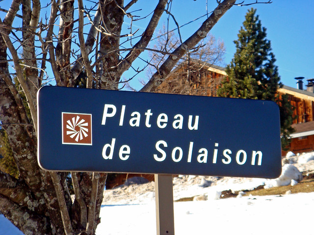
The Bornes mountains already offer some great climbs: the mythical Col de la Colombière, the less-known but very steep col de Romme, climbed in the Tour in 2009, and another gem that the Tour should really discover, the Plateau des Glières. But it's another climb from these mounts that will be presented today. A climb that is a little bit unexpected and quite a surprise. Located above the Arve valley, watching on the cities of Bonneville and Cluses, another plateau could offer to the Tour another great challenge. It's a bit rustic, but hey, the road is asphalted up to the summit and there's room for an entire army of cars and trucks. So it's definitely Tour-worthy.
The Plateau de Solaison, to be honest, was a last-moment discovery for me. And seeing that climb was also a good reason to include this into the list. Its profile numbers are really close to the Alpe d'Huez climb, and the scenery, while not being as spectacular as some climbs featured in this dossier, is quite... Relaxing, and reposing. You can see it on Google Street View. It might not be stellar or incredible, but that's the kind of view that you just enjoy to watch for several minutes.
If the view is eye-candy, the climb up to it however is leg-crushy. Here it is:
Top: 1510 m
Length: 13.2 km
Ascent: 1055 m
Average gradient: 8 %
Climbbybike Difficulty score: 119

Starting from Thuet, the first kilometer is nearly flat before getting the business done. If we except the first and last kilometer, there's a whopping 11 km at 9.1 % average, with 4 kilometers that have double-digit gradients. The road is however large and in good shape, permitting a good restitution of the effort. With the first 5 kilometers at 10 % average, that's the hardest part of the climb before a slightly easier second half. Then, when the first chalets are visible, the road becomes nearly completely flat at 3 % average up to the col.
The main problem for the Tour would be actually recieving a candidature for a stage finish here. As it's a bit pastoral and rural, I doubt the plateau itself could have the money for it, and most of the times, they prefer doing a finish in the nearby city of Le Grand-Bornand, like this year (and even if the stage coming to there is still quite good). But like Glières, the Plateau de Solaison is definitely another climb the riders and the maillot jaune should face in the next years. The Tour des Pays de Savoie already does stage finishes up there. Offering steep slopes and a nice road, everyone should have a nice ride... Well, except the ones who are not climbers.

The Bornes' secret
The Bornes mountains already offer some great climbs: the mythical Col de la Colombière, the less-known but very steep col de Romme, climbed in the Tour in 2009, and another gem that the Tour should really discover, the Plateau des Glières. But it's another climb from these mounts that will be presented today. A climb that is a little bit unexpected and quite a surprise. Located above the Arve valley, watching on the cities of Bonneville and Cluses, another plateau could offer to the Tour another great challenge. It's a bit rustic, but hey, the road is asphalted up to the summit and there's room for an entire army of cars and trucks. So it's definitely Tour-worthy.
The Plateau de Solaison, to be honest, was a last-moment discovery for me. And seeing that climb was also a good reason to include this into the list. Its profile numbers are really close to the Alpe d'Huez climb, and the scenery, while not being as spectacular as some climbs featured in this dossier, is quite... Relaxing, and reposing. You can see it on Google Street View. It might not be stellar or incredible, but that's the kind of view that you just enjoy to watch for several minutes.
If the view is eye-candy, the climb up to it however is leg-crushy. Here it is:
Top: 1510 m
Length: 13.2 km
Ascent: 1055 m
Average gradient: 8 %
Climbbybike Difficulty score: 119
Starting from Thuet, the first kilometer is nearly flat before getting the business done. If we except the first and last kilometer, there's a whopping 11 km at 9.1 % average, with 4 kilometers that have double-digit gradients. The road is however large and in good shape, permitting a good restitution of the effort. With the first 5 kilometers at 10 % average, that's the hardest part of the climb before a slightly easier second half. Then, when the first chalets are visible, the road becomes nearly completely flat at 3 % average up to the col.
The main problem for the Tour would be actually recieving a candidature for a stage finish here. As it's a bit pastoral and rural, I doubt the plateau itself could have the money for it, and most of the times, they prefer doing a finish in the nearby city of Le Grand-Bornand, like this year (and even if the stage coming to there is still quite good). But like Glières, the Plateau de Solaison is definitely another climb the riders and the maillot jaune should face in the next years. The Tour des Pays de Savoie already does stage finishes up there. Offering steep slopes and a nice road, everyone should have a nice ride... Well, except the ones who are not climbers.
For the last two climbs, we're going close to the impossible.Netserk said:I have seen that one before. (Have I posted that one in this thread?)
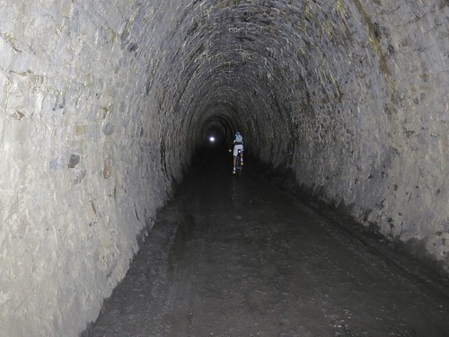
Col du Parpaillon
And I repeat: Jandri is not one of them.
- Sep 3, 2012
- 40
- 0
- 0
Wow, almost at the end of the list already!
I said it a few days ago, but I'll say it again. Thankyou very much Linkinito for all the effort you've put into this
I said it a few days ago, but I'll say it again. Thankyou very much Linkinito for all the effort you've put into this
TRENDING THREADS
-
 Liège - Bastogne - Liège 2026, one-day monument, 26th April
- Started by Krzysztof_O
- Replies: 2K
-
 Paris-Roubaix 2026, one day monument, April 12
- Started by Lequack
- Replies: 2K
-
 Itzulia Basque Country 2026, April 6-11
- Started by Dazed and Confused
- Replies: 2K
-
 Ronde van Vlaanderen 2026, monument, April 5 (men's)
- Started by Krzysztof_O
- Replies: 1K
-
 Teams & Riders The Remco Evenepoel is the next Eddy Merckx thread
- Started by DNP-Old
- Replies: 40K
-
 Teams & Riders Tadej Pogačar discussion thread
- Started by Lequack
- Replies: 44K
-


Cyclingnews is part of Future plc, an international media group and leading digital publisher. Visit our corporate site.
© Future Publishing Limited Quay House, The Ambury, Bath BA1 1UA. All rights reserved. England and Wales company registration number 2008885.