[quote="
Max Rockatansky
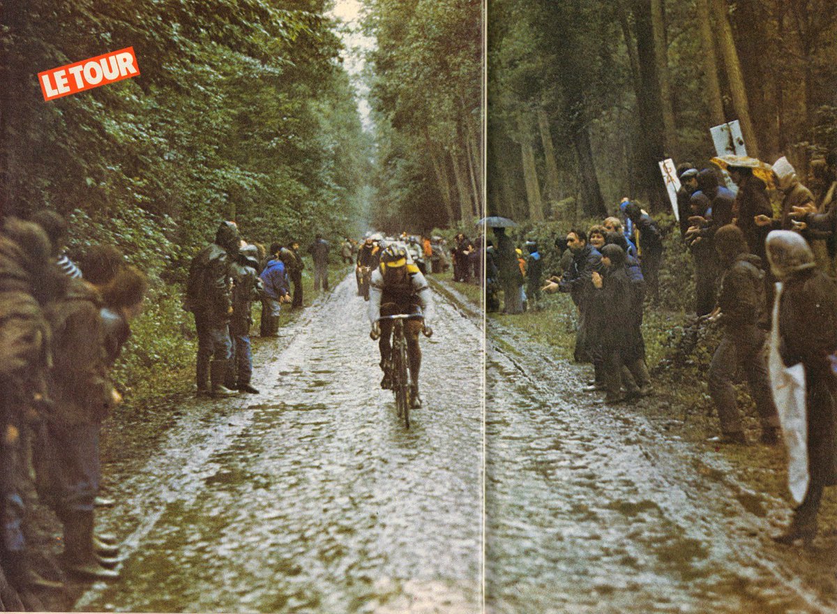
Un vent de ¾ face à décorner les bœufs, une pluie froide quasiment incessante, un enfer pavé échelonné sur 42 km, dont 19,5 sur de très mauvaises sentes, des lieux mythiques (Camphin-en-Pévèle ; Carrefour de l’Arbre) en guise d’apothéose. On se croirait revenu au mois d’avril lorsque Moser s’était imposé à Roubaix, Hinault terminant 4ème à plus de 6’.
From the given itinerary it is possible that they went north from Pommerœul. Pommerœul is near the border and came at kilometer 150. I know that in this border region, there a still some sectors, but I'm not sure, which have been in the TdF stage of 1980. Also funny that Merckx talks about it being a stage for sprinters. :lol:
Edit: Well...the itinerary I posted states 236,5 km, jfazendeiro has information about 249 km and in the footage of the stage it's 263,5 km. ->
https://www.youtube.com/watch?v=Oyh0K1dE4Zc[/quote]
I haven't felt well lately and that is the cause of my delayed answer. I thank very much for the post.
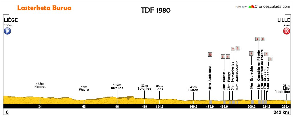
Both the magazine page and the website lagrandeboucle agree in the localities visited during the stage. This is the most reliable part of all the information and I decided to make of it the starting point.
About the point in the stage in which they are located, I have serious doubts. To give an example It isn't possible to connect Liége and Ronquieres, also visiting Wavre in such a small distance. The position of Ronquiéres in the stage can be rigth if existed a neutralized beggining in the stage but I have no knowledge of the practice at the time. This matters to discover the route till the first position and unify the informations about the position of the cobblestones sectors.
About these I have prioritazed the presentation of the stage in the RTF1 transmission. If Camphin-en-pévèle, Carrefour de l'Arbre and Gruson were part of the route, which I think it happened, the distances associated with the sectors aren't very accurate either but is still the source with more informations about the sectors.
RTF says there were only 3 sectors in France territory and the website lagrandeboucle mentions those three. They account for 5,4km.
I also located the entrance in France through Sartaigne beliving that Camphin-en-pévèle was the first french sector and that they had made already 5km in France.
The other sector also mentioned anywhere is Bléhires. I found the Chemin de Bléhires. It has cobblestones but much less than I believe it had in 1980. Today is a well asphalted road and funnily, without motive, in the middle of this long straight road appears 20m of sections larger than the road itself with cobblestones.
The website says it was the 2nd sector in the race but this isn't possible. This chemin is very near the border with France and already closer to Lille than the Parc Scarpe-Escaut. Beetwen this place and Lille there weren't 40km of cobblestones and the map you posted does not show an inversion of route to the Parc. There other chemins nearby, already asphalted but with the same evidences that I believe were used.
Overall with the map I believe that more than 30 of the 42 km of this roads were not only in Wallone but also with some distance from the border.
For now this is what I fell secure about the stage details:
Stage Liége-Lille
Borgworm
Hannut
Jodoigne
Wavre
Ronquières 106,5 km (mag. post and lgb website)
Baudour
Pommeroeu
Bléhires, Brunehaut 2km long
FRANCE - Sartaigne if RTF1 distances are right and Camphin is 1st sector
Camphin-en-Pévèle 1,8km
Carrefour de l'Arbre 2,1km
Gruson 1,1km
Lille (bothanic garden)
Lille
I have contacted L'equipe asking for the edition of the day of thd stage. I haven't received an answer and later discovered that it isn't free to check the archives.

 )
)