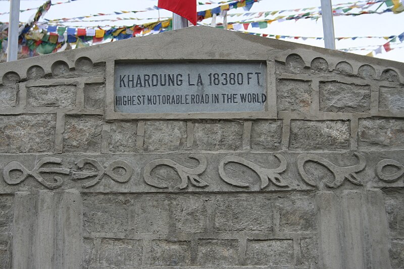
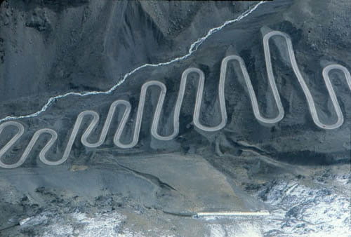
• The Cycling News forum is looking to add some volunteer moderators with Red Rick's recent retirement. If you're interested in helping keep our discussions on track, send a direct message to @SHaines here on the forum, or use the Contact Us form to message the Community Team.

    In the meanwhile, please use the Report option if you see a post that doesn't fit within the forum rules.

    Thanks!

Great "unknown" climbs

Page 9 - Get up to date with the latest news, scores & standings from the Cycling News Community.
khardung la said:
I have to quote this one :) The asphalt is good enough but just passable from June to September. Gradients are not impressive (max about 8-9%, and most often around 5%), but of course height is the biggest issue, specially between the Nakeela Pass and the Taglang La. I got pretty sick there. It took me 7 days, including 1,5 days to acclimatise/recover.

The route could continue from Leh to Kargil and Padum, or even in a loop towards Srinagar and back to Manali. that will add some 3-4 climbs over 4000 m to the already three over 5000 m.

Obviously this is not for professional cyclists :)

To thre best of my knowledge Khardung La goes up to 5359 m. , 1 meter lower than Taglang La.

If you know differently let us know.


The graph shows the height as superior to 5500m.
 
Parquetout

It looks like the " Col de Parquetout" is not mentioned here.

I climbed it last week-end in the cyclosportive "La Marco Pantani", coming from Entraigues, La Valbonnais.

The profile to be found on salite.ch cannot be correct. We did not climb to 1430 m, as implied, before the col at 1382m.

I confirm though that it is very steep. The road is much better than anticipated.
May be the Dauphiné race will try it some day.
 
Le breton said:
It looks like the " Col de Parquetout" is not mentioned here.

I climbed it last week-end in the cyclosportive "La Marco Pantani", coming from Entraigues, La Valbonnais.

The profile to be found on salite.ch cannot be correct. We did not climb to 1430 m, as implied, before the col at 1382m.

I confirm though that it is very steep. The road is much better than anticipated.
May be the Dauphiné race will try it some day.
From that side I'm seeing it as 7,4km @ 8,7%? Think it could be good to descend to Corps and then climb up to Nôtre Dame de la Salette (14km @ 5,7%, final 1,5km @ 9,3%) to finish there.
 
May 8, 2009
376
0
0
Visit site
Le breton said:
To thre best of my knowledge Khardung La goes up to 5359 m. , 1 meter lower than Taglang La.

If you know differently let us know.


The graph shows the height as superior to 5500m.

No, Khardung La is about 5600 m, it is the higher in the region (at least). Check this:
800px-KhardungLa3.jpg


18380 ' = 5602.224 m
 
khardung la said:
No, Khardung La is about 5600 m, it is the higher in the region (at least). 18380 ' = 5602.224 m

I like your millimetric precision:), the road must be really smooth, but frankly I would trust Fred Ferchaux before the Indian army. (I had the pleasure to meet Fred as he was climbing towards the base camp of the Cotopaxi (Ecuador) in 1991).
Here is what he has to say

http://fred.ferchaux.free.fr/divers/colpluo.htm

Maybe you should become San Maberthen La 5813 m.(?):)
 
khardung la said:
No, Khardung La is about 5600 m, it is the higher in the region (at least).18380 ' = 5602.224 m

Here is what Wiki has to say :

There are thousands of named passes around the world, some of which are well-known, such as the Great St. Bernard Pass at 2,473 metres (8,114 ft) in the Alps, the Khyber Pass at 1,027 metres (3,369 ft) between Afghanistan and pakstan, and the Khardung La at 5,359 metres (17,582 ft) in Jammu and Kashmir, India. The Marsimik La at 5,590 metres (18,340 ft) is a lesser-known pass; it is one of the world's highest motorable passes and lies in India, on the northern-most tip of the Changthang Plateau, near the Chinese border.
 
khardung la said:
No, Khardung La is about 5600 m, it is the higher in the region (at least).18380 ' = 5602.224 m

Here is what Wiki has to say :

There are thousands of named passes around the world, some of which are well-known, such as the Great St. Bernard Pass at 2,473 metres (8,114 ft) in the Alps, the Khyber Pass at 1,027 metres (3,369 ft) between Afghanistan and ****stan, and the Khardung La at 5,359 metres (17,582 ft) in Jammu and Kashmir, India. The Marsimik La at 5,590 metres (18,340 ft) is a lesser-known pass; it is one of the world's highest motorable passes and lies in India, on the northern-most tip of the Changthang Plateau, near the Chinese border.

BTW, with the reduced precipitations in the Andes, places as high as 5810m become reachable by bike (i.e. without pushing the bike, but riding it) as on the slopes of Uturuncu (summit ~6000m).

I have unconfirmed info that Sillajuay's summit (also ~6000m, spelling?) could be reachable by car. Bicycle?
 
May 8, 2009
376
0
0
Visit site
Le breton said:
I like your millimetric precision:), the road must be really smooth, but frankly I would trust Fred Ferchaux before the Indian army. (I had the pleasure to meet Fred as he was climbing towards the base camp of the Cotopaxi (Ecuador) in 1991).
Here is what he has to say

http://fred.ferchaux.free.fr/divers/colpluo.htm

Maybe you should become San Maberthen La 5813 m.(?):)

Yeah, there are a diversity of opinions about which pass is higher (and motorable or not). I read something from Janne Corax (Swedish adventurer) saying that there is a higher motorable road somewhere in Tibet (I cannot locate a link).

IMO it is a bit useless discussion, since as someone pointed out it is completely possible to climb higher in the Andes and Himalayas without getting into unpassable roads for a pretty standard bike. I also climbed up to 5000 in the Andes last year and there was no trouble to get even higher up following pretty OK roads.

I just assumed that the info provided by the Indian Army about Khardung La would be reliable, this is why I linked to a photo of the top. I will not change the name of my avatar though :) because I did not climb the "San Maberthen La", but thanks for the tip!
 
Oct 18, 2009
999
0
0
Visit site
Libertine Seguros said:
Now this one is probably never to be used for racing, but for a completely different reason than most already mentioned.

Mount Hermon Ski Station, Israel (27,2km, 5,6%):
http://www.mapmyride.com/routes/view/45655926

At close to 1700m, we are talking the highest paved road in Israel - but even that is a controversial statement since the Golan Heights are of course disputed.

Either way, it's a barren world up there, and climbing for so long in such heat is a punishing, punishing way to go:
1978421200911885624.jpg


Luckily, because of the altitude, it won't be as hot as most of the region, and is one of the few places you can find snow:
ls231.jpg


This is actually a pass, but in the unlikely event of being used for a race it would almost certainly have to be used as a mountaintop finish - the descent road actually crosses the border into Lebanon at one point!

Well, i'm from the neighbouring country Lebanon. In the summer I train at high altitude, live at 1500 meters and I used to climb up to 2550m, passing by the Cedars ski station (it's very well known there). You really suffer from the low oxygen level. And of course in the winter, it's not doable, as it's all covered with snow. Unfortunately, I don't have a picture right now, I i'll post some soon.
 
Oct 6, 2010
56
0
0
Visit site
hfer07 said:
Gustavo- I just wanted to congratulate you & your partner for you amazing blog-I did take the pictures off of it to post them here-but apart from the helpful graphics- I really enjoyed all the photos & descriptions in detail of the mountain passes. Please continue with your wonderful work:)

thanks. we will as soon i returned to colombia next december
 
Oct 6, 2010
56
0
0
Visit site
hmsgenoa said:
Hello Gustavo Duncan (& Asier Bilbao), many thanks for the links, bet you cannot wait to get home!;) The links are great, I'm not familiar with the climb out of Envigado - although I'm thinking may have been up it in a the car - is that another route to Rio Negro?

I love Medellin, I was there in 94 and 95, but without my bike the first time. At the velodromo I sat in the afternoon sun and watched for an hour or so riders training. Afterwards a guy came up to me, though I spoke no Spanish I could understand him because we were both cyclists. He offered me his bike to ride - it was Efrain Dominguez (World Record holder for the flying Kilometre) . I'm sure of one thing, it happened in Colombia but wouldn't have in my country. Colombia is a beautiful country with beautiful People.

I forgot to say that on Alto de las Minas I felt the effects of altitude for the first time, breathing but feeling as though no air was going in. Really weird had to stop rested for 10 seconds set off feeling fine and then rapidly feeling out of breath again.

When you get home enjoy the climbs, I look forward to seeing the pictures on your site. Maybe oneday I'll get back to Medellin and join you for a ride.

you cant imagine how is such breathless feeling in letras at more than 10000 feets of altitude. by the way, i miss a good web page with altimetric profiles of United States mountain ports.
 
arangoiti01.gif


Arangoiti, Navarre, Spain (14,2km @ 5,9%)

This is a very solid climb, one that isn't going to tear people to shreds but one that can most definitely make for a good introduction to the Pyrenées. The tougher stuff is near the top after a bit of short descent, but for the most part, the biggest issue is that that steeper final few kilometres are on some seriously worn tarmac:

5327e18b.jpg


That doesn't look like too much fun!
 
Feb 10, 2011
5
0
0
Visit site
Cret de chatillon

Cret%20de%20Chatillon%20(Annecy).gif

semnozearth.jpg

A great climb from Annecy up the Semnoz mountain. Nothing extreme, just a very nice climb and great to combine with the mont Forclaz at the other site of the lac d'Annecy. I think they did it once in the tour, back in the 70'.
 
decondor said:
Cret%20de%20Chatillon%20(Annecy).gif

semnozearth.jpg

A great climb from Annecy up the Semnoz mountain. Nothing extreme, just a very nice climb and great to combine with the mont Forclaz at the other site of the lac d'Annecy. I think they did it once in the tour, back in the 70'.

Next sunday (Oct 2) a cyclosportive starts in St-Jorioz, 10 km south of Annecy, and will take us to the top of the Semnoz. I wrote the 133km of the event a few days ago and can only recommend it.

About 2 weeks ago they probably held the TT from the outskirts of Annecy to near the top of the Crêt de Chatillon.
 
Aug 15, 2010
261
0
0
Visit site
gustavoduncan said:
you cant imagine how is such breathless feeling in letras at more than 10000 feets of altitude. by the way, i miss a good web page with altimetric profiles of United States mountain ports.

I've just checked out Letras Gustavo, quite a way south from Medellin near Manizales? Shame is I'm unlikely to ever get there, well not for a few years while my young family grow up. I hope tro return to Colombia one day though - plus I don't think I'm fit for a 3000m + climb at the moment!
 
May 21, 2010
808
0
0
Visit site
E.lancs/W.Yorks

Theres a road near too me called the long causeway over the E.Lancs/W.Yorkshire moors between Burnley and Hebden Bridge (well heptonstall to be more specific). At the same time theres a road along a steep valley floor parallel to it going through Todmorden, with several climbs linking the two, all of which ave in 10-12%(but leg breakingly rampy) range over 2-3 km with some very steep ramps to well over 20%.(only 3 could be used for decents realistically though in a race).Theres is also shedloads of other climbs in the area of many differing types that could be strung together one after the other.Also Pendle,Ribble Valley,Yorkshire Dales,Bowland etc are within reach for yet more climbing.ALL could be used in a tour of Britain as good roads for the most part.The climb through Heptonstall is also cobbled.
here is theroretical finish on Heptonstall cobbles which links in 2 other cobbled climbs, but dosent give real idea how steep last cpl of climbs really are as mapmyride averages out gradient too much
http://www.mapmyride.com/routes/view/52354736/?open_ive_done=1&new_route=1
 
Serra Arga/Santuario de Senhora do Minho, Portugal (12,7km, 5,5%):
http://www.mapmyride.com/routes/view/52643728

This one starts out quite benign, but begins to ramp up. Most of the final 6km are at over 8%.

Here's the summit:
16719803.jpg


The level of paving is also a major issue for this climb that really increases its difficulty level past its meagre average percentage:
24873906.jpg


You could definitely make a proper medium mountain stage worthy of the Volta or even the Vuelta in that area of Portugal, with Arga da Cima, the Alto da Portela Grande and San Payo all being relatively nearby.
 
Jul 22, 2009
754
1
0
Visit site
Hello all.

Just wanted to let you know about Paso Liberatores between Chile and Argentina. Tops out at 3,175 meters (looks like the Stelvio actually):

800px-Switchbacks_on_the_road_up_to_Tunel_del_Cristo_Redentor.jpg


Also, I do remember spending a good 4-5 hours looking at the climbing potential between Argentina and Chile and I have to admit their climbs put those in Europe to shame. They can easily put together several 3.000+ meter stages, even 4.000+ meters if they want to. Look at the climbs to Tafi del Valle.

Insane.
 
Nov 11, 2010
3,387
1
0
Visit site
Señor_Contador said:
Hello all.

Just wanted to let you know about Paso Liberatores between Chile and Argentina. Tops out at 3,175 meters (looks like the Stelvio actually):

800px-Switchbacks_on_the_road_up_to_Tunel_del_Cristo_Redentor.jpg


Also, I do remember spending a good 4-5 hours looking at the climbing potential between Argentina and Chile and I have to admit their climbs put those in Europe to shame. They can easily put together several 3.000+ meter stages, even 4.000+ meters if they want to. Look at the climbs to Tafi del Valle.

Insane.

Talk about a snake path
 
Libertine Seguros said:
Serra Arga/Santuario de Senhora do Minho, Portugal (12,7km, 5,5%):
http://www.mapmyride.com/routes/view/52643728

This one starts out quite benign, but begins to ramp up. Most of the final 6km are at over 8%.

Here's the summit:
16719803.jpg


The level of paving is also a major issue for this climb that really increases its difficulty level past its meagre average percentage:
24873906.jpg


You could definitely make a proper medium mountain stage worthy of the Volta or even the Vuelta in that area of Portugal, with Arga da Cima, the Alto da Portela Grande and San Payo all being relatively nearby.

just a few dozen k from where i live. may give it a go one of this days :p
 
May 8, 2009
376
0
0
Visit site
I cycled up to Paso Libertadores, and up to Tafi del Valle from the Cafayate side, and in several other passes in the Andes during a cycle trip. Those 2 are long but as quite often in Central Andes they wouldn´t be so difficult in competition given that they are not very steep. In my experience there are incredible long and high passes almost anywhere in the Andes, but they just tend to combine length and some serious grades in some few regions, particularly Colombia, parts of Ecuador, Peru, and Chile.

In Argentina they tend to be long and not that hard. The climb to Tafí must be about 50 km to climb at 5% average, a bit harder and shorter from the East probably. The climbs to Humahuaca, Paso Jama and other known climbs are higher, have even more kilometers but similar or lower average grade, continuously. I wonder if that is because of their way of building the roads. Look how "perfect" the design is in Paso Libertadores, Argentinian side (below). It is significantly harder in Chile.

Among the passes recently asphalted and in perfect condition for a race there is one in Peru that I love, Abra Pirihuayani, going as high as 4725 m and hosting the most incredible landscape. It is the one at minute 2:21 and minute 4:53 in the following video http://vimeo.com/23402440

Cristo_Redentor2.jpg


Se&#241 said:
Hello all.

Just wanted to let you know about Paso Liberatores between Chile and Argentina. Tops out at 3,175 meters (looks like the Stelvio actually):

800px-Switchbacks_on_the_road_up_to_Tunel_del_Cristo_Redentor.jpg


Also, I do remember spending a good 4-5 hours looking at the climbing potential between Argentina and Chile and I have to admit their climbs put those in Europe to shame. They can easily put together several 3.000+ meter stages, even 4.000+ meters if they want to. Look at the climbs to Tafi del Valle.

Insane.
 
May 6, 2009
8,522
1
0
Visit site
This climb is called The Wall which is located in Monbulk, in the Dandenong Ranges which is outside of Melbourne, maybe on of our Vic posters has done this.

The_Wall_Monbulk_profile.jpg


Average: 5.9 %
Length: 5.1 km
Height start: 277 m
Height top: 580 m
Gradient: 303 m
Maximum: 9.8 %

Maybe they could tie this into the finish of the Sun Tour before the final day crit in Melbourne.
 

TRENDING THREADS

Latest posts