• The Cycling News forum is looking to add some volunteer moderators with Red Rick's recent retirement. If you're interested in helping keep our discussions on track, send a direct message to @SHaines here on the forum, or use the Contact Us form to message the Community Team.

    In the meanwhile, please use the Report option if you see a post that doesn't fit within the forum rules.

    Thanks!

Race Design Thread

Page 17 - Get up to date with the latest news, scores & standings from the Cycling News Community.
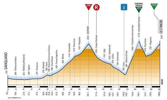
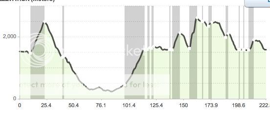
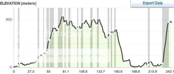
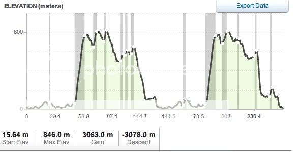
STAGE 16 Pont St.Martin - Borgo San Dalmazzo 248 kms
Longest stage of the Giro.
The stage starts in Valle D'Aosta, and it's flat for most of his lenght.
First 134 kms
canvass.png

But then the peloton heads to west, towards the mighty Colle Della Fauniera.
This climb was used only one time, in 1999. That stage had exactly the same route of this one (at least the second half of it). Pantani attacked at 7 kms to the summit, putting almost 8 minutes into the first-hour breakaway, who reached the peak 30 seconds before him. Gotti and Frattini passed 1 minute after Pantani, while a young Savoldelli reached the summit 2 minutes behind Il Pirata. But the descent of Fauniera is regarded to be one of the most technical descents in the Alps. Savoldelli made perhaps his first legendary descent ever, putting 2'30'' into Pantani (who was a good descender).
On the top of Madonna Del Colletto (the final short climb) Savoldelli had 45'' over Pantani and Gotti, and gained another minute in the descent. The legend of Il Falco was born.
Last 114 kms
canvasb.png


faunip.gif


Fauniera 22.4 @ 7.5%
Mad.Del Colletto 6.7 @ 8.2%
 
STAGE 18 Poggibonsi - Montalcino 233 Kms
The hell of Tuscany ;)
A long, hard stage, with the tough climb to the Monte Amiata before 3 long stretches of Strade Bianche. The third sector (it starts from Bibbiano, for some reason I can't write it in the profile) is the very same of 2010, finish of Montalcino included.
First 173 kms
canvasqh.png

Last 60 kms
canvasmo.png

Monte Amiata: 14 @ 6.8%
Sector 1: 11.5 kms
Sector 2: 7 kms
Sector 3: 14 kms
 
STAGE 20 Rieti - Passo Lanciano 235 kms
Final showdown for the gc. After some minor climbs, the peloton hits the Blockhaus (from the harder side). But, instead of going all the way to the top, it turns down towards Pretoro at 6 kms to the summit, then makes a loop and goes back to climb the Passo Lanciano.

First 75 kms
canvasbm.png

Last 160 kms
canvasuw.png

Gran Sasso D'Italia 16.5 @ 5.5%
Blockhaus 19 @ 7.9%
Passo Lanciano 11 @ 8.5%
 
Sep 8, 2010
1,441
0
0
Visit site
Stage 3: Kitakyushu - Oita, 179 km

2zye6td.jpg


We jump on the island of Kyushu. The city of Kitakyushu has nearly a million inhabitants, so it is not the worst idea to start from the outskirts of the city. After some flat 60 kilometers, the race hits a more mountainous region, called Beppu. :-D Then it's time to collect some points for the mountain jersey. Nothing really difficult. In the final phase of the stage there will be three short power climbs, that can confuse the peloton a bit. It's quite hard to give names to these climbs, without knowing japanese ideograms.

wkmqgh.jpg


Climbs
Cat. 3 // Mt. Kanarase (448m), 5,3k @ 4.7%.
Cat. 2 // Route 409 (694m), 8,2k @ 6.6%.
Cat. 2 // Route 11 (790m), 6,2k @ 5.2%.
Cat. 3 // Ota (420m), 4,9k @ 6.0%.
Cat. 4 // (124m), 2,1k @ 3.3%.
Cat. 4 // (119m), 2,0k @ 3.2%.
Cat. 4 // (131m), 1,9k @ 2.7%.

Kitakyushu
Kitakyushu-2.jpg


Oita
300px-Oita_takasago.jpg
 
Libertine Seguros said:
The first few climbs in stage 20 are uncategorised :eek:
Ehm... My bad :(
The first climb in the second part of the stage is the Gran Sasso D'Italia (pretty famous climb), I just edited.
As for the first part of the profile, I'm searching for data, since I don't know that area very well and I don't know the actual names of those climbs. :D
 
Sep 8, 2010
1,441
0
0
Visit site
Stage 4: Oita - Gokase Highland, 152 km

mb5pv9.jpg


From Oita's World Cup 2002 stadium, the race hits Route 57, passing the volcanic area of Aso. Then we go south, some slight climbing, before the race will go for a final loop with the climb to Gokase Highland. In winter it is a ski resort, in summer it will be perfect for a first test between the main contenders of this race.

kan2gj.jpg


Climbs
Cat. 3 // Route 285 (818m), 4,8k @ 4.6%.
Cat. 1 // Gokase Highland (1381m), 10,2k @ 7.3%.
Cat. 1 // Gokase Highland (1269m), 6,9k @ 8.2%.

Oita
3159_ori_oita_stadium_big_eye.jpg


Gokase Highland
http://www.gokase.co.jp/
 
Mar 13, 2009
2,890
0
0
Visit site
Antigua to Atitlan, Guatemala

/Users/karlbosswalker/Desktop/antigua%20race%20route.jpg
/Users/karlbosswalker/Desktop/profile.jpg
/Users/karlbosswalker/Desktop/climb%20details.jpg

Starting in Anitgua guatemala, heading to Lago atitlan to finish, takes in highway, unpaved, cobbles. You can see the climb details for yourself. I think this would be an ok one day race. A couple of scenery pics too.

/Users/karlbosswalker/Downloads/antigua_guatemala.jpg
/Users/karlbosswalker/Downloads/252f8_antigua-guatemala.jpg
/Users/karlbosswalker/Downloads/Lake-Atitlan.jpg
/Users/karlbosswalker/Downloads/atitl-n_773.jpg
 
Mar 13, 2009
2,890
0
0
Visit site
Anitgua to lago atitlan, guatemala

The Map 225km.
antiguaraceroute.jpg

The Profile
profile.jpg

The climbs in order

Cat Length gradient elevation max slope (min 200m, what's normal?)
1 13.07 7.8% 1014 19.6%
1 18.76 6.1% 1135 15.2%
1 7.09 7.7% 543 19.6%
HC 7.02 14.1% 992 35%
3 2.94 4.3% 127 8.3%
3 2.22 5.5% 121 14.0%
2 4.7 7.0% 328 39.3%

Grades given by Map my ride. I left out what they describe as cat 5.

The start
252f8_antigua-guatemala.jpg

The finish loop from the top of the Cat 2
atitl-n_773.jpg


Different portions take in cobbles and gravel, some brutally steep 100m pinches on cobbles.
Thoughts?
 
Sep 8, 2010
1,441
0
0
Visit site
Stage 5: Misaki - Kochi, 216 km

29pyjoh.jpg


We jump from the island of Kyushu to Japan's smallest island Shikoku. The stage will start from the small coastal town of Misaki. After the Sadamisaki Peninsula, which of course could cause echelons, the race will continue across Shikoku. It's a rough countryside, but no major climbs today.
Because of the tunnels, that are distorting the profile, I won't post one today. After long 216 kilometers, the peloton will reach the city of Kochi for a sprint royale in front of the Castle.

Misaki
SuperStock_4034-63232.jpg


Kochi
kochi+castle.JPG
 
Mar 13, 2009
2,890
0
0
Visit site
Alternate to grafton inverell

The map
Picture2.jpg

The Profile
Picture3.jpg

The climbs

cat length gradient elevation max

3- 4.02km 5.2% 210m 7.7%
3- 6.17km 3.6% 220m 7.6%
3- 7.16km 3.1% 219m 6.7%
4- 3.11km 3.5% 108m
4- 3.16km 3.9% 123m
3- 3.79km 4.2% 163m
4- 2.62km 4.2% 110m
1- 10.23km 6.8% 694m 12.9%

View from the top

800px-Dorrigo_NP.jpg


Starts out in Grafton and makes it's way through 2 national parks, to Dorrigo, turns left and travels through sealed and unsealed roads winding down to Coffs Harbour, along the highway South, Heads inland again hits some unsealed roads "climbs"/bumps, before the cat 1 climb back into Dorrigo.
I figure there is enough there to encourage a long break from the word go, another on the unsealed decent, another on the unsealed climbs, before the final climb, which will come down to time gaps and at the bottom and who has what left.
Even course something for everyone except sprinters.
 
May 6, 2009
8,522
1
0
Visit site
karlboss said:
The map
Picture2.jpg

The Profile
Picture3.jpg

The climbs

cat length gradient elevation max

3- 4.02km 5.2% 210m 7.7%
3- 6.17km 3.6% 220m 7.6%
3- 7.16km 3.1% 219m 6.7%
4- 3.11km 3.5% 108m
4- 3.16km 3.9% 123m
3- 3.79km 4.2% 163m
4- 2.62km 4.2% 110m
1- 10.23km 6.8% 694m 12.9%

View from the top

800px-Dorrigo_NP.jpg


Starts out in Grafton and makes it's way through 2 national parks, to Dorrigo, turns left and travels through sealed and unsealed roads winding down to Coffs Harbour, along the highway South, Heads inland again hits some unsealed roads "climbs"/bumps, before the cat 1 climb back into Dorrigo.
I figure there is enough there to encourage a long break from the word go, another on the unsealed decent, another on the unsealed climbs, before the final climb, which will come down to time gaps and at the bottom and who has what left.
Even course something for everyone except sprinters.

Isn't that more of a Grafton - Grafton though? :p

But seriously, I do like the race profile.
 
Mar 13, 2009
2,890
0
0
Visit site
craig1985 said:
Isn't that more of a Grafton - Grafton though? :p

But seriously, I do like the race profile.

Grafton to dorrigo, or if you come back down the hill to be fair to non climbers
at 310km and have Grafton to Coffs Harbour, but i think 310 might be a little much. I think Coffs to Coffs 260km with two of these loops would be great, but there seems to be some resistance to loops in some circles.

coffsloop2.jpg
 
Mar 13, 2009
2,890
0
0
Visit site
Libertine Seguros said:
I can see this being two separate stages in the Vuelta a Guatemala - it's just insanely brutal for Central American cycling as a 225km megalith. Looks like there are some seriously great climbs available there though.

I can't wait to get back there with a suitable bike and try some of them out. Stay by the lake 1600m up, have the choice of up to the plateau more or less at 2400, or down to sea level every day for training, friendly locals...well most of them. Beautiful, beautiful place and yes, some seriously brutal paved and non paved climbs. Oh and the best rum in the world for those inclined ;)
 
Jul 27, 2009
496
0
0
Visit site
Yep!

craig1985 said:
Isn't that more of a Grafton - Grafton though? :p

But seriously, I do like the race profile.

Whatever it is, I like it!

The NRS is seriously lacking climber's races because it runs in the middle of winter - but I'm assuming that you could run that course right in the middle of the NRS and give the climbers something to aim for besides KOM points.