
Race Design Thread
Page 91 - Get up to date with the latest news, scores & standings from the Cycling News Community.
You are using an out of date browser. It may not display this or other websites correctly.
You should upgrade or use an alternative browser.
You should upgrade or use an alternative browser.
- Jun 12, 2010
- 519
- 0
- 0
- Feb 20, 2010
- 33,254
- 15,788
- 28,180
Stage 2: St Gallen - Samnaun, 213km


Climbs:
Saas im Prättigau (cat.4) 2,0km @ 7,5%
Wolfgangpass (cat.2) 6,0km @ 7,1%
Flüelapass (cat.1) 13,0km @ 6,7%
Samnaun (HC) 15,1km @ 6,3%
As has been the case in recent years, the second stage of the Tour de Suisse is the first MTF (2011 and 13 Crans-Montana, 2012 Verbier). 2008 also had Flumserberg on day 2, so it's only recently 2010 and that appalling 2009 route that haven't set out their GC stall early, and so it is for me.
Though there are four categorised climbs on this long, long stage, it can quite easily be argued that in fact there are only two, as both Saas im Prättigau and Wolfgangpass, which crests in Davos Wolfgang just after the intermediate sprint in Klosters, could be considered part of the same climb - both can be seen on this profile. In addition to this, however, there's only about 3km flat before the road turns uphill again, this time for a sterner test, and a well known Tour de Suisse climb, the desolate heights of Flüelapass - and they are high heights indeed (2383m). I've only awarded it cat.1 status as it's fairly regular from this side; had I not already dished out points at Wolfgangpass it would definitely be HC, as it was in the 2011 stage to Serfaus, however. There is then a technical descent.
The end of this descent is 62km from the finish, so I don't expect any action on Flüelapass, mind. This is, in the finest traditions of opening TdS mountaintops, really a one-climb stage. There's close to 50km of false downhill flat from Susch as we head towards our second tri-state boundary of the day (this one's SUI-AUT-ITA, the previous was SUI-LCH-AUT). There are some similarities between my stage and that 2011 one linked earlier - but this is far tougher. Like in 2011, I go into Austria, but unlike in 2011, this is a very, very brief journey. Then, they took on Norbertshöhe and then a finish on Serfaus; today's job is much tougher.
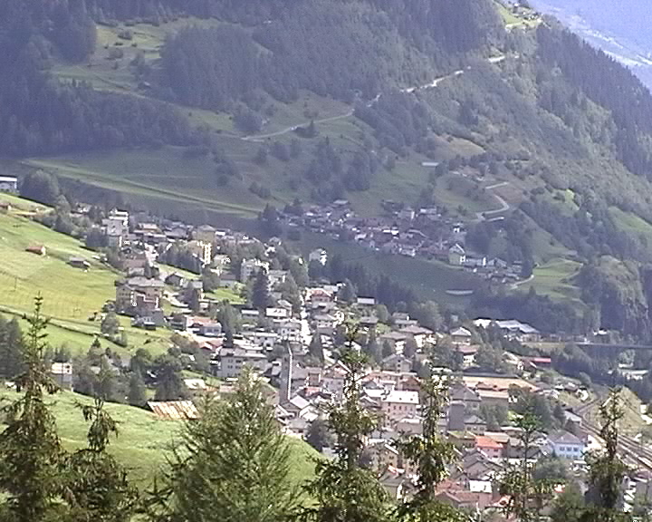
The village and resort town of Samnaun is a tax-free haven popular for that purpose; it's as scenic as you could ask for, pretty and traditional and it's a well-known skiing venue. It's also been rather forgotten by cycling, last being seen in 2002 when a fresh-faced young Kazakh won in horrible rain. There is an easy way up to Samnaun, all within Switzerland but having to go through a pretty horrible tunnel, or there's a hard version which starts in Austria. We're doing the latter, mostly because of the brutal first 3 kilometres. It's a very strange climb; really steep to begin with, then settling in at "normal" gradients of 6-7%, before a brief descent, then it ramps up to 8% again before the last 4km are at fairly low gradients of around 4%. This means that the group is most likely to be shredded immediately, but also that strong riders cannot afford to wait until late on in the climb to attack because the gradients at the top are the easier ones to hold on to. Quäl dich has a more detailed profile which demonstrates gradients of up to 16% on the first section and up to 12% after the first descent. There are dramatic tunnels, border crossings into the Zollfreigebiet and hopefully, when all is said and done, a pretty exciting finale.
St Gallen:

Samnaun:

Climbs:
Saas im Prättigau (cat.4) 2,0km @ 7,5%
Wolfgangpass (cat.2) 6,0km @ 7,1%
Flüelapass (cat.1) 13,0km @ 6,7%
Samnaun (HC) 15,1km @ 6,3%
As has been the case in recent years, the second stage of the Tour de Suisse is the first MTF (2011 and 13 Crans-Montana, 2012 Verbier). 2008 also had Flumserberg on day 2, so it's only recently 2010 and that appalling 2009 route that haven't set out their GC stall early, and so it is for me.
Though there are four categorised climbs on this long, long stage, it can quite easily be argued that in fact there are only two, as both Saas im Prättigau and Wolfgangpass, which crests in Davos Wolfgang just after the intermediate sprint in Klosters, could be considered part of the same climb - both can be seen on this profile. In addition to this, however, there's only about 3km flat before the road turns uphill again, this time for a sterner test, and a well known Tour de Suisse climb, the desolate heights of Flüelapass - and they are high heights indeed (2383m). I've only awarded it cat.1 status as it's fairly regular from this side; had I not already dished out points at Wolfgangpass it would definitely be HC, as it was in the 2011 stage to Serfaus, however. There is then a technical descent.
The end of this descent is 62km from the finish, so I don't expect any action on Flüelapass, mind. This is, in the finest traditions of opening TdS mountaintops, really a one-climb stage. There's close to 50km of false downhill flat from Susch as we head towards our second tri-state boundary of the day (this one's SUI-AUT-ITA, the previous was SUI-LCH-AUT). There are some similarities between my stage and that 2011 one linked earlier - but this is far tougher. Like in 2011, I go into Austria, but unlike in 2011, this is a very, very brief journey. Then, they took on Norbertshöhe and then a finish on Serfaus; today's job is much tougher.
The village and resort town of Samnaun is a tax-free haven popular for that purpose; it's as scenic as you could ask for, pretty and traditional and it's a well-known skiing venue. It's also been rather forgotten by cycling, last being seen in 2002 when a fresh-faced young Kazakh won in horrible rain. There is an easy way up to Samnaun, all within Switzerland but having to go through a pretty horrible tunnel, or there's a hard version which starts in Austria. We're doing the latter, mostly because of the brutal first 3 kilometres. It's a very strange climb; really steep to begin with, then settling in at "normal" gradients of 6-7%, before a brief descent, then it ramps up to 8% again before the last 4km are at fairly low gradients of around 4%. This means that the group is most likely to be shredded immediately, but also that strong riders cannot afford to wait until late on in the climb to attack because the gradients at the top are the easier ones to hold on to. Quäl dich has a more detailed profile which demonstrates gradients of up to 16% on the first section and up to 12% after the first descent. There are dramatic tunnels, border crossings into the Zollfreigebiet and hopefully, when all is said and done, a pretty exciting finale.
St Gallen:
Samnaun:
- Feb 20, 2010
- 33,254
- 15,788
- 28,180
Stage 3: Pontresina - Locarno, 193km


Climbs:
Julierpass (cat.2) 7,0km @ 6,7%
Sufers (cat.2) 7,5km @ 4,7%
Passo San Bernardino (cat.2) 8,8km @ 5,1%
Via Brione Sopra Minusio (cat.3) 3,1km @ 6,9%
After yesterday's mountaintop finish, we now have a transitional stage as we move from the German and Romansch-speaking area to the Italian part of the country. This also entails moving from the highlands to the lowlands, so this stage finishes 1250m closer to the sea in altitude than it began. The stage start is in Pontresina, a small town outside St Moritz that has been chosen because I'm me; it has been the host in the past of major biathlon events thanks to the purpose built stadium for the Olympics back in 1948. It still sees action sometimes but has long fallen from prominence as a venue (though the bid for the 2022 games might bring it back to prominence). The facilities, however, have helped a local family out, as this is the local club of the three Gasparin sisters (Aita, Selina and Elisa L-R) who make up pretty much the whole women's team. I picked this over St Moritz as a stage town pretty much solely for the biathlon connections.
The route first heads north then will loop back to the south; there are some reasonable obstacles in the stage but none like there were yesterday. Julierpass and Passo San Bernardino are both handled from their easier side, and sandwiched between them there's another gradual climb. I anticipate that these will burn off the worst climbers, but with a long descent down into Italian Switzerland and a long flat stretch to come, no real attacking moves can be expected. The descent is long but not overly complicated, then there's the intermediates in Bellinzona to deal with. Around 40-45 kilometres of flat will enable things to come back together unless the front of the bunch is really motoring; then it's time for the sting in the tail - a short climb through the hillside suburbs of Locarno and to Brione sopra Minusio. The real tough parts of this climb are the first 2 kilometres, which spend much of their time around the 10% mark and max out at 17%. Then there's a brief downhill flat stretch before it ramps up to 9% once more to crest 6,5km from the finish. It's a bit of a San Remo type finish - three switchbacks on the descent, but the last 2km are very flat and straight so there's every chance of a move sticking, but also every chance of being caught if the group behind is strong. Could be an intriguing finale. One thing's for sure though; the scenery will be stunning.
Pontresina:

Locarno:

Climbs:
Julierpass (cat.2) 7,0km @ 6,7%
Sufers (cat.2) 7,5km @ 4,7%
Passo San Bernardino (cat.2) 8,8km @ 5,1%
Via Brione Sopra Minusio (cat.3) 3,1km @ 6,9%
After yesterday's mountaintop finish, we now have a transitional stage as we move from the German and Romansch-speaking area to the Italian part of the country. This also entails moving from the highlands to the lowlands, so this stage finishes 1250m closer to the sea in altitude than it began. The stage start is in Pontresina, a small town outside St Moritz that has been chosen because I'm me; it has been the host in the past of major biathlon events thanks to the purpose built stadium for the Olympics back in 1948. It still sees action sometimes but has long fallen from prominence as a venue (though the bid for the 2022 games might bring it back to prominence). The facilities, however, have helped a local family out, as this is the local club of the three Gasparin sisters (Aita, Selina and Elisa L-R) who make up pretty much the whole women's team. I picked this over St Moritz as a stage town pretty much solely for the biathlon connections.
The route first heads north then will loop back to the south; there are some reasonable obstacles in the stage but none like there were yesterday. Julierpass and Passo San Bernardino are both handled from their easier side, and sandwiched between them there's another gradual climb. I anticipate that these will burn off the worst climbers, but with a long descent down into Italian Switzerland and a long flat stretch to come, no real attacking moves can be expected. The descent is long but not overly complicated, then there's the intermediates in Bellinzona to deal with. Around 40-45 kilometres of flat will enable things to come back together unless the front of the bunch is really motoring; then it's time for the sting in the tail - a short climb through the hillside suburbs of Locarno and to Brione sopra Minusio. The real tough parts of this climb are the first 2 kilometres, which spend much of their time around the 10% mark and max out at 17%. Then there's a brief downhill flat stretch before it ramps up to 9% once more to crest 6,5km from the finish. It's a bit of a San Remo type finish - three switchbacks on the descent, but the last 2km are very flat and straight so there's every chance of a move sticking, but also every chance of being caught if the group behind is strong. Could be an intriguing finale. One thing's for sure though; the scenery will be stunning.
Pontresina:
Locarno:
- Feb 20, 2010
- 33,254
- 15,788
- 28,180
Stage 4: Airolo - Bad Schwarzsee, 189km


Climbs:
Nufenenpass (HC) 16,1km @ 7,3%
Grimselpass (cat.1) 12,1km @ 6,6%
Gurnigeplass (cat.1) 9,8km @ 8,0%
This is a second stage with the main climbing in the early parts of the stage and then one big climb for the GC guys later on. It brings to mind stages like this, this and this, with a touch of this thrown in for good measure. I guess what I'm saying is, the Tour de Suisse seems to quite like designing stages so that they can guarantee that only the one climb will be decisive, but making sure that riders have got enough in their legs that they can make it decisive by putting the big climbs early, so this is a little paean to those stages.
The tough climbing comes right out of the blocks, with a classic climb straight from the moment the flag drops. Nufenenpass is a thing of spectacular beauty, and reaches the highest point in the race over its lengthy grind. The descent is equally painful, swooping down the mountainside over steep, twisting roads. This yields almost straight away into another difficult climb, the ridiculous snaking roads of Grimselpass. Admittedly this is once more the easier side of the climb; a bit steeper than the northern side (that we now descend to the first intermediate sprint in Innertkirchen) but only half as long.
After this the difficulties dry up, and it's valley roads for 70km, which will enable a few riders to give their legs a bit of a break and shake out the pains of Nufenen and Grimsel as they take in the breathtaking scenery of the area around the lakes that produce stunning vistas in and around Interlaken. Then more beauty follows around Spiez and Thun before the road turns uphill again. And after a few kilometres of false flat, it flattens out for a couple of kilometres, and then the main GC-relevant climb of the day begins.
The twisting ascent of Gurnigelpass hits you almost straight away with 500m at 11%, to warn you that it isn't kidding. The toughest stretches are in the middle, with a kilometre over 11% to give a perfect launchpad to attack from if necessary. Its scenic rises are also the site of a popular motorbike hillclimb event, so there's plenty of room for fans. Not least at the summit, where there's a Nordic skiing centre that has previously hosted World Cup cross-country skiing and biathlon. This summit is 20km from the finish, with most of the remainder being this inconsistent descent, which starts and ends with some tough technical sections but is a bit easier going in the middle. Then there's just the matter of 6km of slightly uphill false flat to take us to the finish at a resort village by the banks of the Schwarzsee. Expect select groups here rather than soloing and winning and losing minutes, but certainly the GC will be affected.
Airolo:
Bad Schwarzsee:
TheBigT said:Put together two week long stage races a few days ago.
Tour of Eastern Victoria
http://www.tracks4bikers.com/tours/1955
8 stages and a prologue with 3 mountain top finishes.
Always hard to link climbs together in Australia, so stage 4 to Mt. Buller is a bit weak, but stage 3 with the Falls Creek/Hotham double and stage 7 with Donna Buang and Baw Baw should provide plenty of opportunities for the climbers in the GC battle.
Tour of Tasmania.
http://www.tracks4bikers.com/tours/1962
A 7 stage tour of the state that'll highlight a lot of more of its natural beauty than the current tour manages to do. Again lack of climbs make it hard for a proper mountain stage, so we have just a couple of hilly stages and a MTF on the final day to Mt. Wellington. Should go to a strong TTer who can climb.
I decided to do a tour of tasmania too. I decided to stay North. For novelty it isn't actually a 7 day tour but instead 5 race days over 8 days Saturday Sunday, Wednesday, Saturday, Sunday. As a World Tour or week in a GT you could probably go consecutive days, but for the domestique scene it has to be broken up.
- Oct 5, 2011
- 1,103
- 504
- 12,080
Tour Of Cyprus
Well I have to admit i didn't thought about a different categorization for small stage races
Stage 2: Peyia - Lanarca 183km
So this is Stage 2. For the sprinters this is probably the one and only chance to shine here in Cyprus, so you can expect their teams to let a breakaway slip away and just controll it for the rest of the race. On the way, the riders will just have to tackle an easy 3rd Cat climb relatively early in the stage, so no problem at all for the likes of Kittel and Guardini.
The only difficulty that could appear is the wind and some splits caused in the peloton as we ride alongside the coast almost the entire day.


Climbs:
Km 55: 3rd Cat Alektora 3.5km at 4.7%
Libertine Seguros said:I'd argue that in almost any short stage race of that kind of length, 10km at 6,5% is very much 1st category and you'd expect a bit more attacking in a short stage race than you might get in the same stage in a GT.
Well I have to admit i didn't thought about a different categorization for small stage races
Stage 2: Peyia - Lanarca 183km
So this is Stage 2. For the sprinters this is probably the one and only chance to shine here in Cyprus, so you can expect their teams to let a breakaway slip away and just controll it for the rest of the race. On the way, the riders will just have to tackle an easy 3rd Cat climb relatively early in the stage, so no problem at all for the likes of Kittel and Guardini.
The only difficulty that could appear is the wind and some splits caused in the peloton as we ride alongside the coast almost the entire day.
Climbs:
Km 55: 3rd Cat Alektora 3.5km at 4.7%
Stage 1.
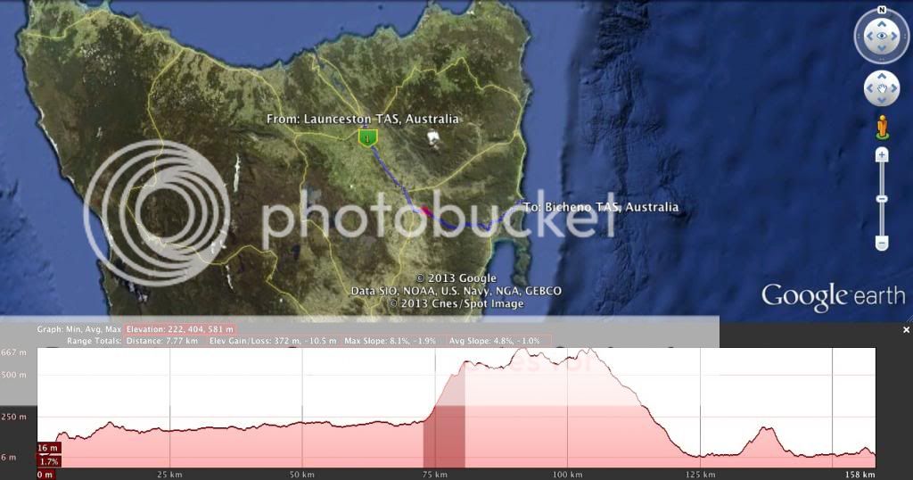
158 km from the largest "city" in the north of the state to the east coast and the sleepy tourist town of bicheno.
"Challenges" of the day
1. At kilometre 2. 1.8km at 5.9%.
2. At kilometre 73. 7km at 5%.
3. At kilometre 132. 4km at 3%. Normally I wouldn't include this, but this is just to point out it shouldn't cause the sprinters any trouble and this is a day for the sprinters.
There are some nice features for the helicopter to look at along the way as we skirt ben lomond national park and freycinet national park.
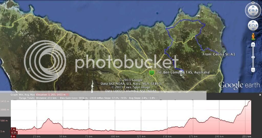
Queen stage 231km
From another east Coast tourist town of St Helens to the only MTF of this tour at Ben lomond.
Challenges for the day.
1. At kilometre 29. 6.3km at 6.2%
2. At kilometre 164. 5.7km at 6.9%
3. At kilometre 184. 4.7km at 4.8%
4. Final climb total. From 211km. 16km at 7.4%
Also final climb in parts taking out small dips.
211km 3.65km at 8.9%, 218km 3.78km at 9.1%, 224km 3.6km at 9.1%
Oh yeah, the final climb is unsealed,
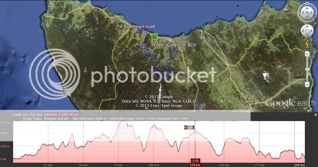
Midweek stage, 206km
Latrobe cycle track to and finishing on Burnie track.
Challenges.
1. kilometre 17. 4.6km at 4.1%
2. kilometre 32. 1.9km at 5.1%
3. kilometre 39. 2.9km at 6.2%
4. kilometre 69. 6.9km at 5.6%
5. kilometre 92. 6.9km at 7%
6. kilometre 112. 1.5km at 5.7%
7. kilometre 116. 3.3km at 7%
8. kilometre 147. 3.55km at 7%
9. kilometre 188. 1.5km at 6.8%
10. kilometre 202 1 km at 10%
Leg breaking medium mountain stage close to 4000m climbing. (Google says just over)from memory most of the longer climbs have middle sections at about 9 or 10% and flatten out at top or bottom for the average to be 6 or 7%. Super tough to control. Break to win for sure.
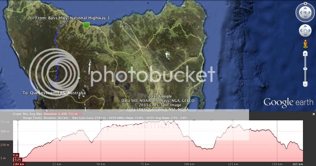
Burnie to Queenstown 165km
Challenges.
Gradual climb at about 2-3% until Hellyer Gorge.
1. Kilometre 45. 5km at 4.7%
2. kilmoetre 113. 2.3km at 8.5%
3. kilometre 117. 5.5km at 4.1%
4. kilometre 154. 2km at 6.1%
Shorter day again a long upward grind but nothing too severe. A couple of bumps towards the end to give the sprinters teams something to control.
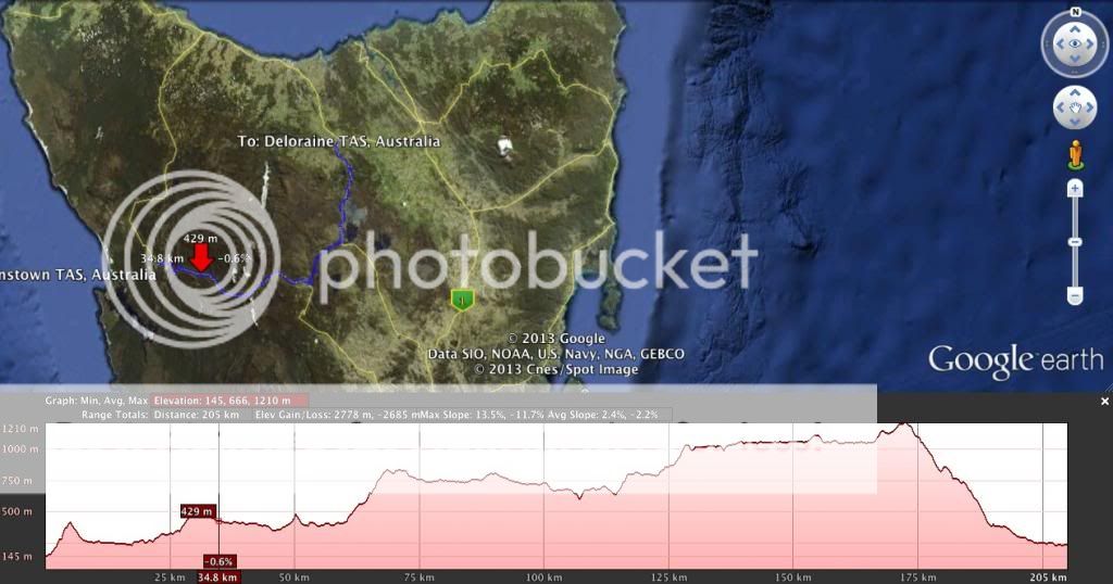
Queenstown to Deloraine 209km and the final day.
Challenges.
1. kilometre 0. 4km at 6.5%
2. kilometre 26. 3.7 at 5.3%
3. kilometre 59. 8km at 5.1%
4. kilmoetre 113. 3.9km at 5%
5. kilmoetre 124. 2.6km at 5.4%
6. kilmoetre 164. 6km at 3%, not categorized, just a point.
Long tough day, but the majority of the climbing and uphill grind is in the first part of the day and a break is unlikely to stick. I'd tip a sprinter to win.
Stage 18: Mauleon-Licharre - Argelès-Gazost, 181km, high mountains

Only four more days to go and it is just now that we tackle the final mountain range of this tour, after the Vosges, Alps and Central Massive.
There's no warming up in the medium mountains after the high speeds of the previous two days.
After a bit less than 30km on uphill false flat the peloton starts the climb of the Col de Soudet, via the Col d'Issarbe. The descent towards Arette is followed by the climb of the Col de marie-Blanque. By now everyone can gues the next climb, that begins after 13km of valley roads: the Col d'Aubisque, one of the true classics in the tour. next and last climb is a novelty in the tour, but a tribute to Nairo Quintana, who excelled at these roads in the 2012 Route du Sud: the Col de Spandelles. This climb is followed by the final descent to the finish.
Climbs:
Col de Soudet: km50, 26.9km @ 4.6%, HC
Col de Marie-Blanque: 95km, 9.5km @ 7.5%, 1st cat
Col d'Aubisque: km132, 16.6km @ 7.2%, HC
Col de Spandelles: 10.2km @ 8.4%, HC
Intermediate Sprint:
Arette, km 71
- Jul 12, 2012
- 8,975
- 591
- 19,080
Hi,
Im currently in the process of making my first stage race, an 8 stage Tour of Britain. Im using the Tracks4bikers website however whenever I get up to 200km distance on my stage it wont let me go any further. Is there any way of moving this distance? I've got a couple of stages ive planned that are around 225km and i dont want to shorten them.
Im currently in the process of making my first stage race, an 8 stage Tour of Britain. Im using the Tracks4bikers website however whenever I get up to 200km distance on my stage it wont let me go any further. Is there any way of moving this distance? I've got a couple of stages ive planned that are around 225km and i dont want to shorten them.
- Mar 24, 2011
- 10,527
- 1,927
- 25,680
you can design the whole stage using bikeroutetoaster.com, then export the gpx file and import it in tracks4bikers. After you did, just choose "edit" to see the track and update profile. You won't be able to modify it though.Pricey_sky said:Hi,
Im currently in the process of making my first stage race, an 8 stage Tour of Britain. Im using the Tracks4bikers website however whenever I get up to 200km distance on my stage it wont let me go any further. Is there any way of moving this distance? I've got a couple of stages ive planned that are around 225km and i dont want to shorten them.
- Jul 12, 2012
- 8,975
- 591
- 19,080
Eshnar said:you can design the whole stage using bikeroutetoaster.com, then export the gpx file and import it in tracks4bikers. After you did, just choose "edit" to see the track and update profile. You won't be able to modify it though.
Thank you, I hope to have the race posted on here by the end of the week.
- Oct 5, 2011
- 1,103
- 504
- 12,080
Tour Of Cyprus
Stage 3: Poli Crysochous - Mt Olympas 180km
So here we are, the last and at the same time the Queen stage of the Tour Of Cyprus. Yesterday was about the fast man but today the GC will be decided and the ones that want to be the winners should definitely be able to climb a bit.
Today's stage starts in a village at the west coast of Cyprus and crawls along the coast with the first hills already looming to warm up the legs in the peloton. After about 50km the road turns inbound and the terrain gets, a little ardennes like, hilly.
Then when the peloton has passed the 100km mark the real climbing begins. The first ascent of our MTF today ,the Mt Olympas, begins. We are not going all the way to the top but with 19,6km at 5.6% it will definitely hurt the peloton. Then after a descent and some false flat we begin to ascent the Mt Olympas for the second time today, on the route the peloton descended 25km earlier after the first ascent. This time we go further up the mountain and the peloton faces 9km at 7.7% with short ramps up to 17.4%.
After the descent, which has some technical parts, we have another 10km of false flat until we reach Mt Olympas again for the final ascent all the way to the top. This final Climb tops at 1872m, is 6km in length and has an average gradient of 7.9% with the last 200-300m being 10% average.
With 4900m of climbing this stage should provide enough opportunities for entertaining racing and the winner of the race will definitely be someone who deserves it after the efforts on this stage.


Climbs:
Km 23: 2nd Cat Pachyammos 5.3km at 6.3%
Km 29: 3rd Cat Alevga 3.3km at 5.5%
Km 48: 3rd Cat Pano Pyrgos 3.3km at 6.7%
Km 57: 3rd Cat Selemani 4.7km at 6.8%
Km 67: 3rd Cat ??? 2.9km at 7.9%
Km 80: 3rd Cat ??? 4.3km at 5.3%
Km 92: 3rd Cat ??? 2.9km at 8.8%
Km 99: HC Mt Olympas 19.6km at 5.6% max 14%
Km 143: 1st Cat Mt Olympas 9km at 7.7% max 17.4%
Km 173: 1st Cat Mt Olympas 6km at 7.9% max 14.5%
Stage 3: Poli Crysochous - Mt Olympas 180km
So here we are, the last and at the same time the Queen stage of the Tour Of Cyprus. Yesterday was about the fast man but today the GC will be decided and the ones that want to be the winners should definitely be able to climb a bit.
Today's stage starts in a village at the west coast of Cyprus and crawls along the coast with the first hills already looming to warm up the legs in the peloton. After about 50km the road turns inbound and the terrain gets, a little ardennes like, hilly.
Then when the peloton has passed the 100km mark the real climbing begins. The first ascent of our MTF today ,the Mt Olympas, begins. We are not going all the way to the top but with 19,6km at 5.6% it will definitely hurt the peloton. Then after a descent and some false flat we begin to ascent the Mt Olympas for the second time today, on the route the peloton descended 25km earlier after the first ascent. This time we go further up the mountain and the peloton faces 9km at 7.7% with short ramps up to 17.4%.
After the descent, which has some technical parts, we have another 10km of false flat until we reach Mt Olympas again for the final ascent all the way to the top. This final Climb tops at 1872m, is 6km in length and has an average gradient of 7.9% with the last 200-300m being 10% average.
With 4900m of climbing this stage should provide enough opportunities for entertaining racing and the winner of the race will definitely be someone who deserves it after the efforts on this stage.
Climbs:
Km 23: 2nd Cat Pachyammos 5.3km at 6.3%
Km 29: 3rd Cat Alevga 3.3km at 5.5%
Km 48: 3rd Cat Pano Pyrgos 3.3km at 6.7%
Km 57: 3rd Cat Selemani 4.7km at 6.8%
Km 67: 3rd Cat ??? 2.9km at 7.9%
Km 80: 3rd Cat ??? 4.3km at 5.3%
Km 92: 3rd Cat ??? 2.9km at 8.8%
Km 99: HC Mt Olympas 19.6km at 5.6% max 14%
Km 143: 1st Cat Mt Olympas 9km at 7.7% max 17.4%
Km 173: 1st Cat Mt Olympas 6km at 7.9% max 14.5%
- Apr 30, 2011
- 49,138
- 31,793
- 28,180
You no longer have to edit it to see it. Not long ago it was changed so that when you viewed it (as you would view a normal track) it showed it correct.Eshnar said:you can design the whole stage using bikeroutetoaster.com, then export the gpx file and import it in tracks4bikers. After you did, just choose "edit" to see the track and update profile. You won't be able to modify it though.
An example
- Mar 24, 2011
- 10,527
- 1,927
- 25,680
yes but that doesn't show the labels it seems.Netserk said:You no longer have to edit it to see it. Not long ago it was changed so that when you viewed it (as you would view a normal track) it showed it correct.
An example
If you click edit and update profile all is nice and full of labels
- Apr 30, 2011
- 49,138
- 31,793
- 28,180
Who gives a ****?Eshnar said:yes but that doesn't show the labels it seems.
If you click edit and update profile all is nice and full of labels
- Mar 24, 2011
- 10,527
- 1,927
- 25,680
I doNetserk said:Who gives a ****?
And I'm not the only one. There's some serious people on the internet - Feb 20, 2010
- 33,254
- 15,788
- 28,180
Struggling to stop myself making some pun about Mount Olympus being a legendary and mythical climb.
Stage 5: Interlaken - Hünenberg, 213km


Climbs:
Brünig Pass (cat.2) 6,2km @ 6,7%
Obernau (cat.4) 4,4km @ 2,5%
Margel (cat.4) 2,1km @ 5,0%
Eichberg (cat.3) 3,0km @ 6,4%
Although there is a reasonably strenuous climb in the early going today, the climbs are all over fairly early and this one should finally give the sprinters a reason to be here. After all, some guys like Sagan and Meersman may be able to make it to the line on the Locarno stage, Sagan at a push in Bad Schwarzsee, but Samnaun is totally not for them. And Sagan and Meersman are not what you'd call pure sprinters either. No, this is a bone for those guys. The stage begins in the beautiful city of Interlaken, so called for obvious reasons, in that colorful Swiss mixing of languages, i.e. "between lakes" in Romance, adopted into German naming practices. A bit like "Neuchâtel" being a blending of the German and French. We passed through Interlaken shortly before the climb to Gurnigelpass yesterday, so the riders won't have too far to go before they head Zürich-ward today. This also means they have the opportunity to verse themselves in Züritüütsch, perhaps the least comprehensible of all varieties of German.
Not a great deal of spectacular riding to be had today, but the sights will still be nice as we pass around the outskirts of Lucerne, and our final climb of the day - with over 100km to go, mind - is from the banks of the Sempachersee. The stage twists north then heads back south before finishing with three laps of a rolling 20km circuit encasing the stage town of Hünenberg, the city of Cham, by the shores of the Zugersee, and the charming traditional village of Dietwil. The final kilometre is mildly uphill, but only at false flat levels, though there is a fairly sharp - but satisfactorily wide - corner with 600m to go. And a bit of blessed relief for the GC riders.
Interlaken:

Hünenberg:

Stage 5: Interlaken - Hünenberg, 213km
Climbs:
Brünig Pass (cat.2) 6,2km @ 6,7%
Obernau (cat.4) 4,4km @ 2,5%
Margel (cat.4) 2,1km @ 5,0%
Eichberg (cat.3) 3,0km @ 6,4%
Although there is a reasonably strenuous climb in the early going today, the climbs are all over fairly early and this one should finally give the sprinters a reason to be here. After all, some guys like Sagan and Meersman may be able to make it to the line on the Locarno stage, Sagan at a push in Bad Schwarzsee, but Samnaun is totally not for them. And Sagan and Meersman are not what you'd call pure sprinters either. No, this is a bone for those guys. The stage begins in the beautiful city of Interlaken, so called for obvious reasons, in that colorful Swiss mixing of languages, i.e. "between lakes" in Romance, adopted into German naming practices. A bit like "Neuchâtel" being a blending of the German and French. We passed through Interlaken shortly before the climb to Gurnigelpass yesterday, so the riders won't have too far to go before they head Zürich-ward today. This also means they have the opportunity to verse themselves in Züritüütsch, perhaps the least comprehensible of all varieties of German.
Not a great deal of spectacular riding to be had today, but the sights will still be nice as we pass around the outskirts of Lucerne, and our final climb of the day - with over 100km to go, mind - is from the banks of the Sempachersee. The stage twists north then heads back south before finishing with three laps of a rolling 20km circuit encasing the stage town of Hünenberg, the city of Cham, by the shores of the Zugersee, and the charming traditional village of Dietwil. The final kilometre is mildly uphill, but only at false flat levels, though there is a fairly sharp - but satisfactorily wide - corner with 600m to go. And a bit of blessed relief for the GC riders.
Interlaken:
Hünenberg:
- Feb 20, 2010
- 33,254
- 15,788
- 28,180
As prompted, a little tweaking to do on this one thanks to one of tracks4bikers' famous ridiculous altitude bugs, but all sorted now.
Stage 6: Reinach - Menziken, 37,1km (EZF)


Much like this year's race, no mountains points being given away in the Contre-le-Montre, however there are categorisation-worthy climbs.
The race's long ITT takes place inside the loop to the north of the finishing circuit in yesterday's stage, linking the towns of Reinach and Menziken. The two towns more or less blend into one another, and there is no real gap between them per se; they have grown into one continuous urban area, however the stage starts in one and ends in the other.
In between the two, it is a rolling time trial that encircles the scenic Hallwilersee, another of those beautiful Swiss lakes, surrounded by forests and hills. Here's an aerial vista. The stage loops around the back of the hills to the right hand side of that shot, mostly over rolling terrain. The toughest challenge in the first half of the time trial is an absolutely ram-rod straight ascent of 3km at between 3 and 4%. Then the riders will arrive at the northern tip of the Hallwilersee and ride along its eastern edge for the duration of its length, which is around 9km of pan flat power roads where the cameras can take in all they like of Switzerland's natural beauty.
And then comes the sting in the tail; to get back to Menziken the riders have to take a climb which comes with a few switchbacks and gets up to 10%. The climb to Schwarzenbach is not super hard or anything - around 3,5km at 5,8% average, but with the first half being much steeper than the second - but coming at the end of a long ITT it could make a difference. After cresting the summit there's a fairly shallow, but very fast and straight descent with very little in the way of technical challenges to take us to the finish, with the riders needing to have enough left to still power through the flat final kilometre. This should be a pretty good test of a rider's skills against the clock.
Reinach:
Metziken:

Stage 6: Reinach - Menziken, 37,1km (EZF)
Much like this year's race, no mountains points being given away in the Contre-le-Montre, however there are categorisation-worthy climbs.
The race's long ITT takes place inside the loop to the north of the finishing circuit in yesterday's stage, linking the towns of Reinach and Menziken. The two towns more or less blend into one another, and there is no real gap between them per se; they have grown into one continuous urban area, however the stage starts in one and ends in the other.
In between the two, it is a rolling time trial that encircles the scenic Hallwilersee, another of those beautiful Swiss lakes, surrounded by forests and hills. Here's an aerial vista. The stage loops around the back of the hills to the right hand side of that shot, mostly over rolling terrain. The toughest challenge in the first half of the time trial is an absolutely ram-rod straight ascent of 3km at between 3 and 4%. Then the riders will arrive at the northern tip of the Hallwilersee and ride along its eastern edge for the duration of its length, which is around 9km of pan flat power roads where the cameras can take in all they like of Switzerland's natural beauty.
And then comes the sting in the tail; to get back to Menziken the riders have to take a climb which comes with a few switchbacks and gets up to 10%. The climb to Schwarzenbach is not super hard or anything - around 3,5km at 5,8% average, but with the first half being much steeper than the second - but coming at the end of a long ITT it could make a difference. After cresting the summit there's a fairly shallow, but very fast and straight descent with very little in the way of technical challenges to take us to the finish, with the riders needing to have enough left to still power through the flat final kilometre. This should be a pretty good test of a rider's skills against the clock.
Reinach:
Metziken:
- Jun 12, 2010
- 519
- 0
- 0
Libertine Seguros said:Hünenberg:
Didn't even knew those houses in front existed. I just drive around the lake sometimes. i prefer the hills in the background for riding.
TRENDING THREADS
-
 Paris-Roubaix 2026, one day monument, April 12
- Started by Lequack
- Replies: 2K
-
 Itzulia Basque Country 2026, April 6-11
- Started by Dazed and Confused
- Replies: 2K
-
 Ronde van Vlaanderen 2026, monument, April 5 (men's)
- Started by Krzysztof_O
- Replies: 1K
-

-

-
 Liège - Bastogne - Liège 2026, one-day monument, 26th April
- Started by Krzysztof_O
- Replies: 177
-

Latest posts
-

-

-

-

-
Liège - Bastogne - Liège 2026, one-day monument, 26th April
- Latest: Coppi-Bartali
-
-
Cyclingnews is part of Future plc, an international media group and leading digital publisher. Visit our corporate site.
© Future Publishing Limited Quay House, The Ambury, Bath BA1 1UA. All rights reserved. England and Wales company registration number 2008885.