
Race Design Thread
Page 99 - Get up to date with the latest news, scores & standings from the Cycling News Community.
You are using an out of date browser. It may not display this or other websites correctly.
You should upgrade or use an alternative browser.
You should upgrade or use an alternative browser.
- Apr 30, 2011
- 49,122
- 31,781
- 28,180
The same thing happened to me in the past, though it wasn't a problem when I viewed it through 'edit track labels'. However for some time now it hasn't been any problem for me, and it shows the stage correctly under normal circumstances.
I just mapped it with bikeroutetoaster, saved it as a gpx file and finally uploaded it on tracks4bikers.
http://www.tracks4bikers.com/tracks/show/162589
I just mapped it with bikeroutetoaster, saved it as a gpx file and finally uploaded it on tracks4bikers.
http://www.tracks4bikers.com/tracks/show/162589
- Jun 28, 2012
- 798
- 0
- 0
Way to tease us by going right past the Zoncolan, but not going over it.fauniera said:Giro d'Italia
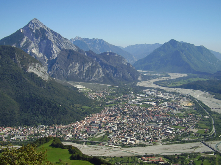
Stage 14: Gemona - Pontebba, 230 km
part 1:

part 2:


This is the longest stage of this Giro, and one of the hardest. The first climbs are Clauzetto (7,7 km 5,5%) and Forcella di Monte Rest (11,1 km 5,9%). Things are getting more serious with Passo del Pura (11,8 km 7,4%), which is followed by the relatively easy Sella di Razzo (12,8 km 6,1%).
With 80 km to go the monster that is Monte Crostis waits. 14 km at 10,1%, let that sink in. All this on a narrow and spectacular road. On the top there is of course the famous Panoramica delle Vette. It's a strada sterrato, but a lot has been invested into safety prior to the Giro 2011. Here is an excellent video of the Panoramica delle Vette and the following descent. As you can see, the descent, while highly technical and very narrow, has very good tarmac, probably all new for the Giro.
I think chances are really good that the race blows apart on the Crostis, either the ascent, oder the sterrato, or the descent. Which leaves 46 km of racing, which should be pretty interesting. There is nearly no respite, as the road climbs again to Forcella di Lius, which looks tiny in comparison with the Crostis, but is a decent climb with 9,4 km at 5,3%.
The final climb of the day is Passo del Cason di Lanza. You will remember it from the Giro stage to Altopiano del Montasio this year. It's a two part climb. First 4,6 km at 8,9%, then a short descent, then the brutal second part with 5,5 km at 10,3%. After that the riders will descend into Pontebba, which is a steep affair for the first 8 km. I call this the queen stage, in total there are 6.300 vertical meters to climb.
Although isn't the actual road route over the Crostis a bit further north, and also a bit more difficult?
- Oct 12, 2013
- 2,430
- 31
- 6,530
SetonHallPirate said:Although isn't the actual road route over the Crostis a bit further north, and also a bit more difficult?
No, that's Crostis up there. A bit more north and you are in Austria.
")
- Oct 12, 2013
- 2,430
- 31
- 6,530
Giro d'Italia
Stage 15: Tolmezzo - Seiser Alm, 199 km


I am a fan of having three mountain stages in a row, following Fignon there. I might have overdone it, though. I am afraid that this weekend might be a bit too hard. Well, you'll be the judge.
Stage 15 starts where Libertine's stage 13 started, in Tolmezzo. While Libertine sent the riders west via the Passo del Pura, in my stage the riders have the pleasure to tackle the much easier Passo della Mauria. Easy is over though after Valle di Cadore. What follows are five climbs through the Dolomites, with basically no flat between them.
First up is Passo Cibiana (10,5 km 6,3%, the last 5 km have 9,5%), followed by the quite often used Forcella Staulanza (16,6 km 5,7%) and the mighty Passo di Fedaia (14,1 km 7,4%, with the last 5 km at 11,3%). Things should get serious here, and there are still 50 km to go. Passo di Sella (11 km 7,2%) is the Cima Coppi of this Giro at (rather lame) 2.240 m.
After the descent into beautiful Grödnertal one more climb is waiting for the riders, and it is a killer. The road from St. Ulrich to Seiser Alm, which has been asphalted recently, is 4,6 km long and 12,8% steep. The first 2,4 km have 14,5%. For comparison: the hard last 5 km of Alpe di Pampeago "only" have 11,1%. This should be a massacre.
Next day is a much deserved rest day in Trentino.
Tolmezzo:
Seiser Alm:

Stage 15: Tolmezzo - Seiser Alm, 199 km
I am a fan of having three mountain stages in a row, following Fignon there. I might have overdone it, though. I am afraid that this weekend might be a bit too hard. Well, you'll be the judge.
Stage 15 starts where Libertine's stage 13 started, in Tolmezzo. While Libertine sent the riders west via the Passo del Pura, in my stage the riders have the pleasure to tackle the much easier Passo della Mauria. Easy is over though after Valle di Cadore. What follows are five climbs through the Dolomites, with basically no flat between them.
First up is Passo Cibiana (10,5 km 6,3%, the last 5 km have 9,5%), followed by the quite often used Forcella Staulanza (16,6 km 5,7%) and the mighty Passo di Fedaia (14,1 km 7,4%, with the last 5 km at 11,3%). Things should get serious here, and there are still 50 km to go. Passo di Sella (11 km 7,2%) is the Cima Coppi of this Giro at (rather lame) 2.240 m.
After the descent into beautiful Grödnertal one more climb is waiting for the riders, and it is a killer. The road from St. Ulrich to Seiser Alm, which has been asphalted recently, is 4,6 km long and 12,8% steep. The first 2,4 km have 14,5%. For comparison: the hard last 5 km of Alpe di Pampeago "only" have 11,1%. This should be a massacre.
Next day is a much deserved rest day in Trentino.
Tolmezzo:
Seiser Alm:
- Oct 12, 2013
- 2,430
- 31
- 6,530
Giro d'Italia
Stage 16: Trento - Mantova, 155 km


The last week begins with a flat stage. To make things a bit more difficult for the sprinters, there is a 7 km climb on the shores of Lake Garda, followed by numerous little climbs in the area between Lake Garda and Verona. The most prominent of those is Custoza, which suffered from its hilltop location by being the site of not one, but two gruesome battles in the 19. century. The last 30 km are flat though, so it should be a sprint. The finish is right outside the Castello di San Giorgio (on the left).
Trento:
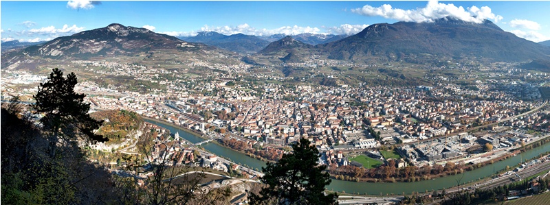
Mantova:

Stage 16: Trento - Mantova, 155 km
The last week begins with a flat stage. To make things a bit more difficult for the sprinters, there is a 7 km climb on the shores of Lake Garda, followed by numerous little climbs in the area between Lake Garda and Verona. The most prominent of those is Custoza, which suffered from its hilltop location by being the site of not one, but two gruesome battles in the 19. century. The last 30 km are flat though, so it should be a sprint. The finish is right outside the Castello di San Giorgio (on the left).
Trento:
Mantova:
- Feb 20, 2010
- 33,250
- 15,780
- 28,180
Told you you'd catch up with/overtake me - I've been away for a few days, and come back to find you in the same area as me
Liking that there are tougher routes to Siusi than 2009's (there's of course also the alternative southwestern route using Trotzstraße instead of the main road, which turns us another 18km @ 6-7% type route but with the last 8km at 10%). My next stage uses the easier version though, though it's not meant to be decisive like yours.
And Fedaia!
- Oct 12, 2013
- 2,430
- 31
- 6,530
Giro d'Italia
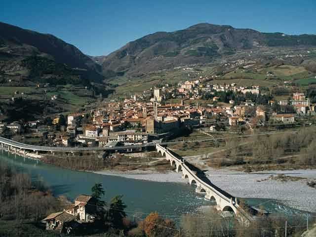
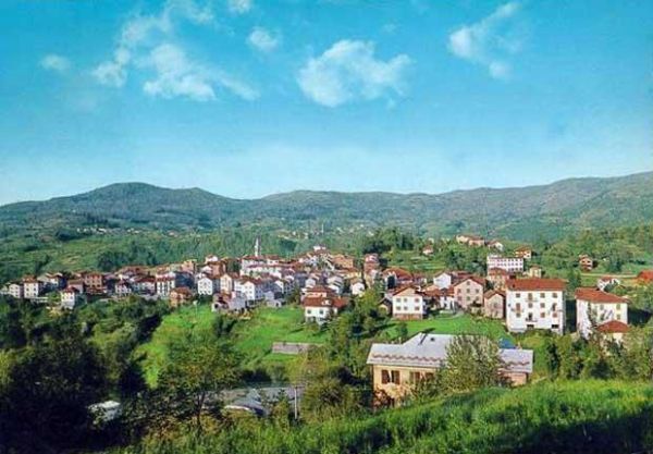
Stage 17: Bobbio - Fontanigorda, 104 km


The shortest stage of this Giro (except the time trials), but certainly not the easiest. And while the stage is only 104 km long, it manages to pass through four regions. It starts in Emilia, then cuts through Lombardia and Piemonte, before finishing in Liguria. From Bobbio the road immediately goes upwards to Passo del Penice (13,3 km 6,5%). This is followed by Passo del Giova (16,2 km 5,7%), Capanne di Carrega (12,2 km 6,5%) and the final dig into Fontanigorda (3,6 km 5,7%, including a stretch of 1,8 km at 7,3%). This should be a very intense stage and getting broadcasted from the start, which is always nice.
Bobbio:
Fontanigorda:
Stage 17: Bobbio - Fontanigorda, 104 km
The shortest stage of this Giro (except the time trials), but certainly not the easiest. And while the stage is only 104 km long, it manages to pass through four regions. It starts in Emilia, then cuts through Lombardia and Piemonte, before finishing in Liguria. From Bobbio the road immediately goes upwards to Passo del Penice (13,3 km 6,5%). This is followed by Passo del Giova (16,2 km 5,7%), Capanne di Carrega (12,2 km 6,5%) and the final dig into Fontanigorda (3,6 km 5,7%, including a stretch of 1,8 km at 7,3%). This should be a very intense stage and getting broadcasted from the start, which is always nice.
Bobbio:
Fontanigorda:
- Dec 16, 2011
- 345
- 0
- 0
Tour de france without Alps and Pyrenees
Those are some heavy stages Fauniera! I especially like the stages with the Crostis and Alpe di Siusi, but I think combined with the friday stage it's a bit to much. Not sure if the roads that day are wide enough as well. But overall, I'm really enjoying your Giro so far!
Stage 7: Vittel - le Grand Ballon
It's time for the first mountains! Today's stage will finish on the famous Grand Ballon. The Ballon will be tackled from a new side, making it the first genuine HC climb of this Tour. To reach the summit, the riders have to gain nearly 1000 meters of height within 12 kilometres. The average gradient is around 7.5%, but the climb features some steep sections. As this profile shows.
Earlier in the stage the peloton have to tackle the Ballon d'alsace (10 KM, 6.5%), the col du Hundsruck (3.5 KM, 5%) and the col du Siberloch (8,5 KM, 6,5%).
- Dec 16, 2011
- 345
- 0
- 0
Tour de france without Alps and Pyrenees
Stage 8: Colmar - Gerardmer (147 KM)
The second Vosges stage will be very hard, with no moment of rest. No less than 7 caegorized climbs are included on today's route. The first half of the stage features some relatively easy climbs: les Trois Epis (10 Km, 5%), le Col du Calvaire (11 KM, 6%) and la Collet du Linge (6 KM, 5%). This should be enough to create a solid breakaway. However, the key part of this stage is between kilometres 80 and 110 when the peloton have to climb the Petit Ballon (10 KM, 7.7%) and the Col du Platzerwasel (8 KM, 8%) straight after each other. This couple of climbs provides great opportunities to attack, since the remaining of the course isn't that hard again. Still, if all the attacks have failed the riders get some late opportunities on the Col de la Grosse Pierre (4 KM, 7.4%) and the steep finishing climb to la Mausalaine (1.4 KM, 9.5%). The last climb is likely to feature in the coming Tour as well, but propably not after such a stage!

Note: originally I wanted to include the Col du Herrenberg on this stage. This is a short, but very steep climb from Kruth towards the Route des Cretes. However, according to streetview the road surface was of very bad quality. Has anyone some ideas about the true state of that road?
Stage 8: Colmar - Gerardmer (147 KM)
The second Vosges stage will be very hard, with no moment of rest. No less than 7 caegorized climbs are included on today's route. The first half of the stage features some relatively easy climbs: les Trois Epis (10 Km, 5%), le Col du Calvaire (11 KM, 6%) and la Collet du Linge (6 KM, 5%). This should be enough to create a solid breakaway. However, the key part of this stage is between kilometres 80 and 110 when the peloton have to climb the Petit Ballon (10 KM, 7.7%) and the Col du Platzerwasel (8 KM, 8%) straight after each other. This couple of climbs provides great opportunities to attack, since the remaining of the course isn't that hard again. Still, if all the attacks have failed the riders get some late opportunities on the Col de la Grosse Pierre (4 KM, 7.4%) and the steep finishing climb to la Mausalaine (1.4 KM, 9.5%). The last climb is likely to feature in the coming Tour as well, but propably not after such a stage!
Note: originally I wanted to include the Col du Herrenberg on this stage. This is a short, but very steep climb from Kruth towards the Route des Cretes. However, according to streetview the road surface was of very bad quality. Has anyone some ideas about the true state of that road?
Bordeaux-Paris
Apologies if I have posted this before but I would love to see the Bordeaux-Paris return. It was one of my favorite races during its later years.
The race was a one-day event run from 1891 to 1998, covered 600 km, and for half the distance the riders were motor paced .
Past winners include:
Tom Simpson
Jacques Anquetil
Ferdi Kubler
Louison Bobet
No doubt this would be a difficult race to stage today but I would like to see it staged every four or five years.
Alternately I would like to see a similar type race but perhaps 300 km in length. Perhaps betwen two capitals with the race being reversed every other year.
- Oct 12, 2013
- 2,430
- 31
- 6,530
Another_Dutch_Guy said:Those are some heavy stages Fauniera! I especially like the stages with the Crostis and Alpe di Siusi, but I think combined with the friday stage it's a bit to much. Not sure if the roads that day are wide enough as well.
Yeah, i guess i agree. I should soften stage 13 or 15, the Crostis stage stays as it is. I like your Tour so far, as well as roundabout's Giroesque Tour.
- Jun 28, 2012
- 798
- 0
- 0
Just out of curiousity, has anybody tried to do a routing of the Republic of Korea (aka South Korea)? Strangely, I can make stages in the Democratic People's Republic of Korea (North Korea), but not South Korea. Which one is the totalitarian dictatorship?
BTW, I've used both ridewithgps and mapmyride so far.
BTW, I've used both ridewithgps and mapmyride so far.
- Oct 12, 2013
- 2,430
- 31
- 6,530
fauniera said:Yeah, i guess i agree. I should soften stage 15.
For instance like this:


Shorter and much easier with Passo Tre Croci, Passo di Valparola (new Cima Coppi) and Grödnerjoch, while keeping the tough final climb to Seiser Alm. No Fedaia.
Edit: By the way, Grödnerjoch is one of the most beautiful climbs in the Dolomites.


- Dec 16, 2011
- 345
- 0
- 0
Hmm, I think you should keep this stage untouched. Libertine won't forgive you if you skip the Fedaia . You'll be fine if you skip the Monte San Giacomo on stage 13, it's propably to small for road cycling anyway. But you're in charge. All three would definetely become interesting stages!
. You'll be fine if you skip the Monte San Giacomo on stage 13, it's propably to small for road cycling anyway. But you're in charge. All three would definetely become interesting stages!- Oct 12, 2013
- 2,430
- 31
- 6,530
I see your point but i stick with the easier stage to Seiser Alm. A super hard stage 15 could take the sting out of stages 13 and 14, and i don't want that. And i like Monte San Giacomo. Note that it's so narrow only for a few km. If that provokes chaos, all the better.
- Feb 20, 2010
- 33,250
- 15,780
- 28,180
Nothing like the chaos I will provoke on you for removing the queen of the Dolomites, the majestic peak of Marmolada, the mighty ruler of Alpine summit passes.
Fedaia! FEDAIA!
Fedaia! FEDAIA!
- Oct 21, 2013
- 30
- 0
- 0
I decided to play a bit with Tracks4Bikers and i am already hooked to it. Soon i will try to do a Grand Tour but for now, my first mapping:
I went for a stage in les Pyrénées starting in Argelès-Gazost and finishing in Piau Engaly. I wanted badly to have a stage finishing in Piau Engaly because it isn't climbed since 1999, when riders were literally flying up mountains. On a side note, it is the most elevated ski station in les Pyrénées.
It features Tourmalet followed by le Col d'Aspin, little climb to Lançon, le Col d'Azet and the final climb to Piau Engaly. The only reason Tourmalet is included is because i wanted a HC climb right on the beginning.
Climbs:
Col du Tourmalet: 20km @ 7,3%
Col d'Aspin: 12.8km @ 5%
Col d'Azet: 7,5km 2 8,3 %
Piau Engaly: 20km @ 5,2%
I have mapped some alternative stages with the same start and finish places as in Tour 2014 route:
Stage 1: Leeds - Harrogate; 21 km
Since I made the mountain stages harder, there is need for more TT kms and I like the idea to start with longer ITT than just prologue. This one is not too flat either (unlike the second ITT on penultimate day).

Stage 11: Besancon - Oyonnax; 179 km
I am happy with other stages in the first week and second weekend so let's move to stage 11 after rest day. We don't know the real one, but I would like something like this before sprint stage to Saint-Etienne.
Climbs:
Col de la Croix de la Serra (141) - 12 km; 5%
Col du Sentier (169) - 5.5 km; 7%

Stage 1: Leeds - Harrogate; 21 km
Since I made the mountain stages harder, there is need for more TT kms and I like the idea to start with longer ITT than just prologue. This one is not too flat either (unlike the second ITT on penultimate day).
Stage 11: Besancon - Oyonnax; 179 km
I am happy with other stages in the first week and second weekend so let's move to stage 11 after rest day. We don't know the real one, but I would like something like this before sprint stage to Saint-Etienne.
Climbs:
Col de la Croix de la Serra (141) - 12 km; 5%
Col du Sentier (169) - 5.5 km; 7%
Stage 13 (version 1): Saint-Etienne - Chamrousse; 228 km
Similiar to original stage, but with less flat before final climb (which is easier from this side) and some new climbs as well.
Climbs:
Col de la Republique (12) - 8.4 km; 5.5%
Quaix-en-Chartreuse (141) - 3.4 km; 8.5% (last 2 km with almost 11%)
Col de la Porte (155) - 11.1 km; 7.7%
Col de la Faita (169) - 5 km; 8.2%
Col du Coq (173) - 2.1 km; 9%
Route d'Allevard (202) - 9 km; 6.5%
Chamrousse (228) - 18,5 km; 6.3%

Final kilometers:

Stage 13 (version 2): Saint-Etienne - Chamrousse; 233 km
Here the main obstacle is definitely final climb to Chamrousse from the hardest side, but 233 kilometers with some nasty ascents will surely tire some legs too.
Climbs:
Col de la Republique (12) - 8.4 km; 5.5%
Laffrey (168) - 6.8 km; 9.2%
Col de Malissol (185) - 2.3 km; 8.3%
La Morte (200) - 3.7 km; 7.5%
Chamrousse (233) - 18.2 km; 7.8%

Final kilometers:

Which of these two versions do you like more?
Similiar to original stage, but with less flat before final climb (which is easier from this side) and some new climbs as well.
Climbs:
Col de la Republique (12) - 8.4 km; 5.5%
Quaix-en-Chartreuse (141) - 3.4 km; 8.5% (last 2 km with almost 11%)
Col de la Porte (155) - 11.1 km; 7.7%
Col de la Faita (169) - 5 km; 8.2%
Col du Coq (173) - 2.1 km; 9%
Route d'Allevard (202) - 9 km; 6.5%
Chamrousse (228) - 18,5 km; 6.3%
Final kilometers:
Stage 13 (version 2): Saint-Etienne - Chamrousse; 233 km
Here the main obstacle is definitely final climb to Chamrousse from the hardest side, but 233 kilometers with some nasty ascents will surely tire some legs too.
Climbs:
Col de la Republique (12) - 8.4 km; 5.5%
Laffrey (168) - 6.8 km; 9.2%
Col de Malissol (185) - 2.3 km; 8.3%
La Morte (200) - 3.7 km; 7.5%
Chamrousse (233) - 18.2 km; 7.8%
Final kilometers:
Which of these two versions do you like more?
Stage 17: Saint Gaudens - Pla d'Adet; 182 km
This is the queen stage. One, which the real route lacks. It is not overly long in distance, but with so much climbing it could be carnage. It is possible that helpers will be dropped quite early and then anything can happen, although the profile doesn't look like the best for long range attacks.
Climbs:
Bois de Tir (18) - 3.2 km; 6.2%
Col de la Serre (27) - 5.7 km; 5%
Port de Balés (62) - 11.7 km; 7.7%
Col de Peyresourde (87) - 9.5 km; 7.6%
Col de Val Louron-Azet (104) - 7.4 km; 8.3%
La Hourquette d'Ancizan (128) - 10 km; 7.8%
Col d'Aspin (144) - 5.4 km; 7.3%
Lancon (162) - 4.3 km; 9%
Pla d'Adet (182) - 10.5 km; 8.2%

Stage 18: Pau - Hautacam; 161 km
Last mountain stage should open possibilities for those who want to change something about the result of the race. I think this one does it much more than the original one, although I like Tourmalet.
Climbs:
Col de Marie Blanque (56) - 9.2 km; 7.7%
Col d'Aubisque (93) - 16.6 km; 7.2%
Col de Spandelles (127) - 10.2 km; 8.4%
Hautacam (161) - 15.8 km; 7.6%

This is the queen stage. One, which the real route lacks. It is not overly long in distance, but with so much climbing it could be carnage. It is possible that helpers will be dropped quite early and then anything can happen, although the profile doesn't look like the best for long range attacks.
Climbs:
Bois de Tir (18) - 3.2 km; 6.2%
Col de la Serre (27) - 5.7 km; 5%
Port de Balés (62) - 11.7 km; 7.7%
Col de Peyresourde (87) - 9.5 km; 7.6%
Col de Val Louron-Azet (104) - 7.4 km; 8.3%
La Hourquette d'Ancizan (128) - 10 km; 7.8%
Col d'Aspin (144) - 5.4 km; 7.3%
Lancon (162) - 4.3 km; 9%
Pla d'Adet (182) - 10.5 km; 8.2%
Stage 18: Pau - Hautacam; 161 km
Last mountain stage should open possibilities for those who want to change something about the result of the race. I think this one does it much more than the original one, although I like Tourmalet.
Climbs:
Col de Marie Blanque (56) - 9.2 km; 7.7%
Col d'Aubisque (93) - 16.6 km; 7.2%
Col de Spandelles (127) - 10.2 km; 8.4%
Hautacam (161) - 15.8 km; 7.6%
TRENDING THREADS
-
 Paris-Roubaix 2026, one day monument, April 12
- Started by Lequack
- Replies: 2K
-

-
 Itzulia Basque Country 2026, April 6-11
- Started by Dazed and Confused
- Replies: 2K
-

-
 Ronde van Vlaanderen 2026, monument, April 5 (men's)
- Started by Krzysztof_O
- Replies: 1K
-
 Teams & Riders The Remco Evenepoel is the next Eddy Merckx thread
- Started by DNP-Old
- Replies: 39K
-
 Teams & Riders Tadej Pogačar discussion thread
- Started by Lequack
- Replies: 44K


Cyclingnews is part of Future plc, an international media group and leading digital publisher. Visit our corporate site.
© Future Publishing Limited Quay House, The Ambury, Bath BA1 1UA. All rights reserved. England and Wales company registration number 2008885.