• The Cycling News forum is looking to add some volunteer moderators with Red Rick's recent retirement. If you're interested in helping keep our discussions on track, send a direct message to @SHaines here on the forum, or use the Contact Us form to message the Community Team.

    In the meanwhile, please use the Report option if you see a post that doesn't fit within the forum rules.

    Thanks!

Race Design Thread

Page 173 - Get up to date with the latest news, scores & standings from the Cycling News Community.
Stage 7: Tokushima - Mt Rokuroyama - 133km

Nzkz277.png


zqzCxf9.png


The first of 2 crucial stages which will decide who wins the Tour of Japan. The stage is short as we have a very long transfer tonight for tomorrows stage. We move on to Shikoku Island and the riders will zig-zag their way around the mountains of the Tokushima province. The first few k's are flat before the climbing starts with 3 Cat 2 climbs. With half of the stage gone the peloton reach the longest test of Mt Kumuso which will be climbed for over 13km's, as with each of the final 3 climbs it is irregular and features some false flat but also some steeper slopes of 10%. The penultimate test of Ashimgamru is split in two halfs. The first 3k's average over 10% with a short descent in the middle before the final 4km's @ 7.5%.
The final climb of Rokuroyama is a fraction over 10km's long and at almost 8% could be a key test for what remains of the leading group. The steepest slopes are in the first half of the climb but it does have a nasty sting in the tail. With less than 1k to go the riders hit 200m section at 21%, with the final few hundred metres also at a testing 9%.

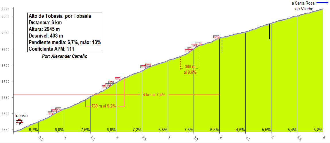
Rokuruyama 10.1km @ 7.8% profile:
Ai8DqqJ.png


xvREFVJ.png

sesM5OR.png

ij1IhoW.png
 
Oct 4, 2015
417
1
3,030
Visit site
I've been lurking around the site for a while, but now I've decided to create myself an account.
I have created several stage race designs in my free time (got a bit addicted to it honestly), so I guess I could post some of them here, instead of leaving them to catch dust in my computer forever...

I'll start with a three-week Vuelta a Colombia, because that's where I'm from (kinda unusual that I've never seen stage race designs in Colombia here...).

PROLOGUE: Cartagena - Cartagena (7km)

10zbuxu.png

14uj3lt.png


The race begins with a flat prologue in the streets of Cartagena, on the northern coast of Colombia. The first half of the stage goes parallel to the beach, then the stage turns towards the old city for a technical section, before ending in front of the San Felipe Castle, built by the Spanish during the colonial era, to defend the city against privateer raids.

Cartagena (Bocagrande)
BOCAGRANDEcatrtaena.jpg

Cartagena (San Felipe)
Castillo-San-Felipe-Cartagena-Colombia-Evento-11.jpg
 
Oct 4, 2015
417
1
3,030
Visit site
STAGE 1: Arjona - Baranoa, 153km
2s0ztk6.png

5n0hfc.png

The race continues with a hilly stage, with two short yet steep climbs: Piojó (3 km @ 10,1%) and Tubará (2,6km @ 9%), followed by a hilly section before the arrival at Baranoa. While the first climb is apparently too far for a successful attack to happen, the second may see some attacking, particularly with the complicated terrain at the end of the stage. Also to take into consideration is the climate, with temperatures well over 30°C being commonplace in the region.

Arjona
arjona.jpg

Baranoa
baranoa-iglesia_y_parque.jpg
 
Oct 4, 2015
417
1
3,030
Visit site
Thank you!
STAGE 2: Sabanalarga - Santa Marta, 160km
2q0odus.png

28tf983.png

Next comes a flat stage through exposed roads, particularly at the Ciénaga Grande de Santa Marta (Great Santa Marta Marsh in spanish) halfway through the stage. Heavy crosswinds are common here, so beware.

Sabanalarga
dummy-640x310-3.jpg

Santa Marta
santamarta.jpg
 
Oct 4, 2015
417
1
3,030
Visit site
STAGE 3: Bosconia - Aguachica, 213km
2lwvpg7.png

2prrytw.png

After a long transfer (aprox. 150km), we start heading away from the north coast, and take on one last flat stage before the mountains. A the small climb to Loma de los Chivos (2,7km @ 5%), 7km away from goal, is the only difficulty in this stage... besides the tropical heat, of course.

Bosconia
1568wmg.jpg

Aguachica
AGUACHICA-CESAR.jpg
 
I think the reason we've probably not seen much in the way of designs in Colombia is two-fold really. One is, like with Italy, trimming the race down to the right length while still including all of the legendary climbs you want to is an absolute nightmare, because there are so many great options, and secondly because the Giro offers so many top options that everybody knows, and there have been lots of undertakings there, you can always see how to give something a fresh spin. I've designed courses in Colombia before but never posted because I've never had a race route I've been truly happy with; Gustavo Duncan and Asier Bilbao have a few fantasy Vueltas a Colombia at their site at http://altimetriascolombia.blogspot.com, Gustavo sometimes posts here as well.
 
Oct 4, 2015
417
1
3,030
Visit site
Yeah, I check out their website regularly. In fact, it has inspired several of the stages in my Vuelta. Also it has some very good climb profiles, which I'll probably use once I get to the high mountain part of the race.
I also have lots of Giro designs in my computer, and may have posted one... however, since some people were commenting that they were overloaded with Giro designs due to the Challenge (which I missed, unfortunately), I decided to try something different.

Alright, we're done with the flat stages for now. Let's get to businesses.

STAGE 4: AGUACHICA - MESA DE RUITOQUE, 187km
i5zpdx.png

2ustnv4.png

(note: I don't know the "official" name of several of the climbs along the route; for most of them I'm naming them after nearby towns)
The first summit finish of the race comes at the end of a difficult medium-mountain stage with no less than seven categorized climbs: Contadero (2,8km @ 7,5%), La Esperanza (3,9km @ 7,3%), La Ceiba (2,6km @ 7,2%), Portachuelo (3,3km @ 7,4%), El Playón (3,7km @ 7,1%) and Bucaramanga (4,4km @ 6,2%), plus the summit finish at Ruitoque (5km @ 6,6%) after a hilly run around the city of Bucaramanga. Very hilly stage, so expect some breakaways on the early climbs, and attacks in the summit finish.

Mesa de Ruitoque
Lamej976b80d39lamej976g.jpg
 
Oct 4, 2015
417
1
3,030
Visit site
STAGE 5: PIEDECUESTA - CHIQUINQUIRÁ, 243km
xaw64k.png

2zez0hj.png


The longest stage of the Vuelta starts near the foot of last stage's summit finish. The riders will then face two climbs very early in the stage: the short climb to Los Curos (3,1km @ 6,3%), followed by the very long Chiflas, the very first category 1 climb of the race (28,4km @ 4,9%). Afterwards there's some 150km of hilly terrain, with two categorized climbs in Piñalandia (6km @ 5%) and Juan Nieto (3.9km @ 5,5%), before the key climb of the stage: Garavito (24,3km @ 4,3%). Not the steepest climb, but after over 220km of racing (and with the summit comming at over 2600m above sea level) this one should hurt. The stage finishes after some flat terrain, at the very scenic city of Chiquinquirá.

Piedecuesta
web_b90227041_big_tp.jpg

Chiquinquirá
ix8vag.jpg
 
Oct 4, 2015
417
1
3,030
Visit site
STAGE 6: CHIQUINQUIRÁ - SOPÓ, 167km
2jc78s5.png

103fpcp.png

Next comes a mostly flat stage... at over 2500m above sea level. Besides the far-out Tierranegra (9,7km @ 4,8%) and the very easy Guatavita (2,8km @ 3,9%) there's not much to prevent a sprint from being the outcome here.

Sopó
sop-pbot.jpg
 
Oct 4, 2015
417
1
3,030
Visit site
STAGE 7: COTA - ZIPAQUIRÁ (52km, ITT)
s6u6pl.png

11gkd3l.png

Long, flat time trial at high altitude, to select which riders will be fighting for the general classification from now on. The finish is at the entrance of the famous Catedral de Sal, in Zipaquirá.

Cota
cota-cundinamarca_1386156843.jpg

Zipaquirá
zipaquira_cindinamarca_60.jpg
 
Oct 4, 2015
417
1
3,030
Visit site
(credit for the profiles goes to http://altimetriascolombia.blogspot.com.co)

STAGE 8: PARQUE JAIME DUQUE (BRICEÑO) - CÓMBITA, 232km
2vki0sx.png

1zvdbeq.png

Climbs: Sisga (5,5km @ 4,6%), Ventaquemada (2,5km @ 4,8%), Soracá (11,6km @ 5,9%), Tunja (3km @ 5,3%), Piedra Gorda (6,8km @ 5,2%), Motavita (2,9km @ 6,4%), Alto Blanco (4,6km @ 7,2%)

Big medium mountain stage for Sunday. 232km, 3715m of elevation gain, seven categorized climbs, all over 2800m above sea level. Starting from Parque Jaime Duque (an amusement park located 30km north of Bogotá), the stage features some hilly terrain during the first 90km... then, after a longer downhill section, we face the hardest climb of the day: the cat.1 climb to Soracá.
Alto%2Bde%2BSorac%C3%A1.png

After the climb, there's some more hilly terrain until Puente de Boyacá (known for being the site of the decisive battle in Colombia's independence war), followed by another descent before facing the cat.2 climb to Piedra Gorda (after km 12 in the profile below)
Copia%2Bde%2BAltimetr%C3%ADa%2BPiedragorda.png

This is quickly followed by the short climb to Motavita, then by a flat section through the city of Tunja until the first pass through the finish line in Cómbita, Nairo Quintana's hometown. There's still one more cat.2 left to go, though: Alto Blanco (after km 4 in the profile below)
Alto+Blanco.png

Then, there's a final descent back to Tunja, followed by the short uphill finish in Cómbita.

Parque Jaime Duque
parque-jaime-duque-panoramica.jpg

Cómbita
2ngyjcl.jpg
 
Pricey_sky said:
fauniera said:
Great to see a Vuelta a Colombia here. Tour of Japan has some great stages so far, but maybe one or two easier stages would make it better balanced?

Yes absolutely, I just wanted to use the best of Japan and create a climbers/stage hunters race. Stage 1 and 9 could still be sprints though.

It's hard to resist the temptation ;) , when you got so many candies in sight :p .
 
Oct 4, 2015
417
1
3,030
Visit site
STAGE 9: TUNJA - DUITAMA, 182km
10wme4n.png

23wqtxu.png

Climbs: Los Curíes (9km @ 4,4%), Tobasía (6km @ 6,7%), El Cogollo (4,2km, 6,6%, three laps).

Before the first rest day, we have one last medium mountain stage. Starting in Tunja, the route goes through the Vargas Swamp, site of another key battle in Colombia's independence war, before facing the long cat. 3 climb to Los Curíes. Then, after a flat section, the stage enters its decisive part, starting with the cat.2 climb to Tobasía.
Alto%2Bde%2BTobas%C3%ADa%2Bpor%2BTobas%C3%ADa.png

Afterwards, the riders will enter a slightly-shortened version of the (in)famous 1995 World Championship Road Race circuit, where they will tackle the climb of El Cogollo (right to left in the profile below) thrice, before finishing at Duitama.
Alto%2Bdel%2BCogollo.png


Tunja
tunja.jpg

Duitama
4568471521_7d74f3339d_o.jpg


REST DAY 1: DUITAMA, transfer to Madrid (no, not that one :p )
 
Giro d'Italia

(Thu) stage 5: Manfredonia - Ostuni, 228 km

71cpaUX.png

kPoV2vv.png


Further south we go on our second day in Puglia. This should be one for the sprinters, but the tricky finale gives other riders chances too.

Manfredonia
foto-aerea-manfredonia-1024x768.jpg


The stage is flat, first along the coast, then inland on the Altopiano delle Murgea. After 178 km we enter the "land of the white cities". Alberobello is the first beautiful town we visit, it is famous for its unique trulli buildings (and slightly less famous for Leonardo Piepoli).

Alberobellos-Trulli.jpg


Locorotondo is next, after 185 km. Then we leave the Murge for a moment just to climb it again. This is the only climb of the day, and an easy one (there are two steps, the second is 2 km at 5,5%), but since there are only 20 km left to race at the top, this might be used to get rid of the Ivan Quaranta type of sprinters.

The climb leads to Cisternino, another dream in white. From there the course is slightly downhill to our destination, Ostuni. Ostuni is a town of 32.000 people and known as "La Città Bianca". It is probably the most spectacular of the white cities.

Ostuni
fmazb6drwwnh.jpg


Map and profile of the final kilometers:

QkVFkMG.jpg

0ChR41V.png


With 2 km to go, the riders will ride along the ancient city walls, certainly the most spectator-friendly part of the stage.

8ky48kjx8e.png


After a short descent, a muro of 300 meters at 11,7% might be the springboard for an decisive attack. In any case the sprinters will suffer here and some of them might lose contact.

ycfp85315apg.png


The rest is flat except for a little rise inside the final kilometer.

7n2i17dz3e49.png


finish
ds47dfxu95id.png
 
Jun 30, 2014
7,060
2
0
Visit site
Vuelta a Venezuela stage 9: Morón - Choroní; 220km
4a5s849mvdg.png

c1s6m13z2d8o.png

Durning the first days of the Vuelta we had the absurdly long Andes climbs, the last 2 will feature the shorter but steeper climbs of the Cordillera de la Costa.
The stage starts in Morón, an important industrial town, the most important electricity centre of Venezuela, Planta Centro is also located close by.
The first half of the stage features lots of rolling terrain and a cat. 2 climb, 9km at 6,6% with a max. gradient of 11%.
Then we ride through Valencia, the 3rd largest city in Venezuela and perhaps the most important economic hub of the country, and alongside the Lago de Valencia,
the third largest lake in Venezuela.
In Maracay the final climb of the day starts, the road from Maracay to the Henri Pittier National Park (the oldest National Park in Venezuela), 12,3km at 8,2%. Afterwards we have a long descent that will bring the riders to Choroní, a Village mostly known for the stunning Playa Grande beach that lies nearby. It is also worth mentioning that during the 19th century Choroní was known for his cocoa industry and high quality cocoa, but today tourism has become the most important economic sector.
This stage should have an impact, but with the next stage featuring an even harder final climb I don't expect them to go all out on this stage, a small group will form on the final climb, but someone could always have a bad day and loose a big amount of time. Maybe someone could try to gain some time on the final descent.
Morón:
440px-Iglesia_Santa_Ana_de_Mor%C3%B3n.jpg

Moron-aflame.png

Choroní:
1024px-Street_in_Puerto_Columbia%2C_Choron%C3%AD.jpg
 
Oct 4, 2015
417
1
3,030
Visit site
STAGE 10: MADRID - LA DORADA, 175km
eu3f9y.png

29le0c9.png

Climbs: El Vino (3.9km @ 5,4%), El Trigo (15,2km @ 5,7%), La Mona (4,5km @ 5,5%)

The second week starts with a typical Vuelta a Colombia stage, coming down from the highlands and into the Magdalena river valley. Three climbs along the way, the hardest being the cat. 1 Alto del Trigo. A breakaway may make it, but with the sprinter's chances being so few and far between from now on they'll probably try to prevent that from happening.

Madrid
34yd7i0.jpg

La Dorada
2ih4e4l.jpg
 
Oct 4, 2015
417
1
3,030
Visit site
STAGE 11: PUERTO SALGAR - PUERTO BERRÍO, 159km
xdwly0.png

1y8sn.png


Before we enter the mountains again, we have one last flat stage. It's a short one too, so expect the sprinters to take this one. It may be the last chance for them, anyway.

Puerto Salgar
IMG_2914_3.JPG

Puerto Berrío
24barra04e050_big_tp.jpg
 
Oct 4, 2015
417
1
3,030
Visit site
STAGE 12: PUERTO BERRÍO - ALTO DE LAS PALMAS, 199km
2w57t6x.png

i1g2fo.png

Climbs: La Quiebra (7km @ 7%), Las Palmas (12,1km @ 8,3%)

We enter back into the high mountains, this time with a very Unipublic-style stage. The route starts where it left off the day before, then heads through a gradual uphill road towards the city of Medellín, the second largest city in Colombia with over 2.4 million inhabitants.
From there, we'll have to climb this:
LAS+PALMAS+por+El+Tesoro.jpg

The climb to Las Palmas is somewhat irregular, with its hardest part coming right at the middle, with 1 km at over 14% before tapering off to a more reasonable 7-8% until the summit finish.

Alto de las Palmas
121zplw.jpg
 
Oct 4, 2015
417
1
3,030
Visit site
Alright, this race hasn't been that hard so far, has it? Well, let's kick it up a notch.

STAGE 13: ITAGÜÍ - GUARNE, 223km
10yj5vk.png

11k8ivp.png

Climbs: Fredonia (11km, 6,4%), Minas (42,3km, 4,3%), EL Escobero (9,6km, 9,7%), Santa Elena (16,2km, 6,3%)

The Medellín area is rich in very difficult climbs; most roads coming in and out of the city have to negotiate the very steep walls of the valley it's located in. The queen stage of this Vuelta a Colombia uses several of these.
The stage starts in Itagüí, part of Medellín's metropolitan area, then descends down a secondary road, taking on the cat.2 climb to Fredonia along the way. Then, after a short flat run, the route comes back up through the main road, through the extremely long Alto de Minas.
MINAS+vert.+La+Pintada.jpg

After the very long, very irregular climb, the riders face another flat stretch, before entering back into Metro Medellín.
Then, they'll have to go through this:
ESCOBERO+vert.+Envigado.jpg

And then, without any flat in-between whatsoever, they'll face this:
SANTA+ELENA+por+Medell%C3%ADn.jpg

Then, after an irregular descent, the riders will reach the finish line in Guarne. A very difficult, very long stage, which will most likely shake up the general classification.

Itagüí
b5cc4-municipio-itagui-001_1435453928_1439066372.jpg

Guarne
140122030144FOTO%20GUARNE600.jpg
 
Oct 4, 2015
417
1
3,030
Visit site
I decided to keep stage 12 with only the summit finish because it was already running a bit long (no Escobero since I intended to use it for stage 13 anyway). I could've added some other climbs west of Medellín (there's a wall even harder than El Escobero, whose descent ends not too far from the beginning of Las Palmas), but didn't think of it until now, so...

STAGE 14: CALDAS - MANIZALES, 183km
30s84uf.png

2uzcg37.png

Climbs: Minas (9,1km @ 6,4%), Manizales(26,7km @ 4,6%), Palogrande (3,2km @ 7,4%)

Right after the queen stage, the last stage of week 2 leads to a hilltop finish. After the typical descent from Minas and run through the Cauca river valley, the riders take on the long ascent to Manizales from the west. The route then goes around the city, then starts going up again from the south, through a short yet steep road, ending at the Palogrande stadium in the eastern half of the city.

Caldas
caldas_antioquia.jpg

Manizales
2ltomkk.jpg


REST DAY 2: MANIZALES, transfer to Armenia.
 

TRENDING THREADS