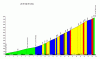
Race Design Thread

Page 205 - Get up to date with the latest news, scores & standings from the Cycling News Community.
Now for a race outside of my usual norm. I've tried to keep it varied, with some sprinters' stages, some HTF stages and some rouleur stages; being a six-man-team race I think it could be tough to control, especially with bonus seconds at sprints, but it's not going to be a mountain odyssey...

Piiri Suomi/Tour of Finland (The Race of the Midnight Sun)

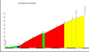
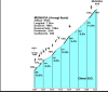
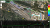
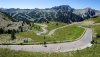
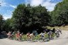
Stage 1: Ivalo - Sodankylä, 169km

2uqc1te.png


ofyq2o.png


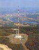
We start up in the very north of the country, in the small town of Ivalo. Known for one of Europe's northernmost airports and a car testing area, it's also most people's gateway to Lapland with seasonal flights allowing people to see the aurora borealis, meet Santa Claus, go husky sledding and all those other stereotypical Lapland things people imagine. This race will be taking place mid-season though, probably trying to piggyback the Arctic Tour of Norway to create a mini-season, so more likely to see Midnight Sun than the aurora.

34604993.jpg


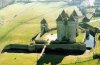
This stage more or less follows historic highway 4 down all the way from start to finish; this means starting by the shores of Inarijärvi (Lake Inari) and going through the popular resort town - known for its skiing and its popular spa - of Saariselkä, through some forest wilderness and arctic circle scenery.

paisaje-en-saariselka.jpg


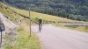
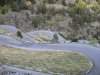
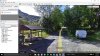
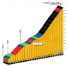
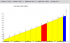
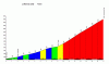
The one obstacle of the day is actually something of a misnomer. The legend goes that the cars of the 1940s were unable to deal with the difficult gradients in cold climate of highway 4 between Ivalo and Sodankylä, with one particular section causing many cars to break down; it was believed that there was some magnetic force within the hill that was causing the cars to fail, and it was swiftly dubbed "Magneettimäki", or "Magnetic Hill". Nowadays, the highway has been slightly relocated; it still passes over said hill, but not by the notorious tight section of legend, rather over a nice, wide, well-paved road a little way from its predecessor.

saa8-nelostielumiaita-ja-kelkkareitti-Magneettim%C3%A4en-p%C3%A4%C3%A4ll%C3%A4.jpg


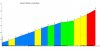
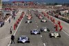
The old road is still there though - maybe if I was finishing the stage in Saariselkä I'd have used it, but it is a dirt road in quite poor condition now. Anyway, after this it's plain sailing; mostly slightly downward progress from the 360m peak to 180m for Sodankylä, mostly passing through evergreen forests and the lands of reindeer and moose, though there is the occasional interruption from a point of other interest - for example the Tankavaara gold prospecting village. When the riders eventually arrive in the finish town there's a short - 11km or so - circuit to negotiate, but this one should be for the sprinters - however bonus seconds being available for two intermediate sprints within the last 25km may mean an earlier catch, as durable classics men with a good bunch kick who can get over some smaller obstacles may believe they have a chance of winning this one outright. Certainly the likes of Roelandts and van Avermaet would have interest if their teams showed up, because they have more options to come.

Keskusta%201.jpeg
 
Stage 2: Sodankylä - Levitunturi, 217km

55s2sn.png


15grx3a.png


GPM:
Ylläs (cat.2) 3,2km @ 5,6%
Levin Ympärystie (cat.3) 1,2km @ 5,3%
Levitunturi (cat.1) 4,1km @ 6,8%

The second stage in the far north of the country starts where we left off yesterday, in Sodankylä, and is the first of three uphill finishes in the race. In fact, this is the toughest uphill finish of the race; Finland in general is rather starved of high mountains, and so producing a really hilly race isn't really possible. Therefore it may be unconventional to stick the hardest finish so early, but the idea is that, with the time bonuses available in sprints and the small teams, to put the riders who'll have the most trouble defending that lead and most struggle to protect that lead up near the front early on, and so here we go through the stage with the most climbing (!) on stage 2 of 8.

It's not necessarily a stupendously difficult stage; there are few options for real multi-mountain odysseys here, but given the climate and the small team sizes we can hope to open up some gaps akin to those opened up in the Arctic Tour of Norway on the stage to Målselv - around 30" separated the top 10 before bonuses. That seems fine to me. The Målselv climb is a little shorter than Levitunturi, with about a 1% steeper average gradient, however the last kilometre here averages over 9% which should be good for some gaps and the 4km length or so will balance this out between puncheurs and the medium mountain type riders who show up. Before we get to Levi, however, there's over 200km of riding to do. Most of it, like with yesterday's stage, is flat and through evergreen forests.

34125399.jpg


The roads are a bit narrower and in less good condition than yesterday's, at least for the first half of the stage, which could have an effect come the end of the race (hopefully). The riders continue along these routes until they get to Kittilä, another northern Finnish town with a small airport that is seasonally popular, making its money from a gold mine in the summer, and from tourists transiting through to reach Finland's best-known and best-loved ski resorts nearby in the winter.

From here we then take a long and wide looping circuit to the west of Kittilä, taking us around and past the day's first climb, to the popular ski resort of Ylläs.

yllas_paakuva_hiihtokeskus.jpg


In addition to skiing, Ylläs also hosts the famous Lainio Snow Village, although it will of course be out of operation at the time the riders go through. If they're not interested in alpine skiing, and instead prefer to do some actual skiing (remember, the race is in Finland, so proper skiing is Nordic skiing as far as they're concerned), then there are hundreds of kilometres of trails out of the village of Äkäslompolo, which we pass after the descent, along with mile upon mile of unspoilt wilderness.

After several rolling and undulating kilometres we return to Kittilä, or rather just north of it, and double back on a little of our route, before turning left past the airport and heading the Finland's largest and most famous alpine spot, the 531m mountain of Levitunturi. With over 40 pistes and over 200km of cut cross country trails, and being so far north that snow lingers well into May despite the low altitude, it is a popular resort; it also hosts the Alpine Skiing World Cup many years, however due to the short length of runs it is only suited to slalom racing at the World Cup level. We actually circle around the mountain to include a small climb to the south of it, and to have a late intermediate sprint in the small town of Sirkka which also functions as the base of the Levi resort.

levi2.jpg


The final climb then begins; it gradually steepens, with as previously mentioned a final kilometre at over 9%. This should start to break the field apart, and give us some GC gaps even if relatively small; in a stage race like this it will be about controlling gaps and maintaining and attacking small advantages.

21247476.jpg


normal_Levi_Maailmancup_rinne.jpg
 
Stage 3: Rovaniemi - Iso-Syöte, 197km

2a5evid.png


2hi321y.png


GPM:
Pikku-Syöte (cat.3) 1,5km @ 5,2%
Iso-Syöte (cat.2) 2,5km @ 7,2%

SetWidth760-aerial-view-of-rovaniemi-finland-760x300.jpg


After a fairly sizable southward transfer past Kittilä, we arrive in Rovaniemi, today's start town. With a population of over 60 000 it's just about the largest city in this part of Finland, and also serves as the "official" hometown of Santa Claus, being where Santa Claus Village is and where mail is redirected, much as Veliky Ustyug functions in the same role for Ded Moroz. This is likely therefore where riders will overnight ahead of the second puncheur stage in a row, this one finishing at Iso-Syöte.

This is our last stage in the very north, and is a long and mostly rolling trek southeastwards; partway through the stage we leave Lapland once and for all, and settle in Northern Ostrobothnia. On the way we pass through a couple of marked sites, most notably the Ranua area, a scenic region with over 500 lakes that we will be snaking through, along with a quite famous wildlife park enabling the public to get up close and just about personal with bears (including those of the polar variety and their absurdly adorable cubs), moose, wildfowl and so on.

17625675.jpg


The crux of the stage for the riders, however, is when we head through the Syöte National Park, the southernmost fell region of Finland. Indeed, today's stage town of Iso-Syöte is named after a peak that is arguably the southernmost legit mountain that the country has, at 432m above sea level... the area is the same kind of wide open, tranquil forestland that suggests the Tour of California's inland stages, until you feel the temperature at least!

Einfahrt-in-den-Syoete-National-Park.jpg


The finish of the stage comes with a loop and a half of an undulating circuit around the village of Naamanka and the small alpine skiing resort of Pikku-Syöte. We are only climbing the smallest part of this, around the base, because we need to loop back on ourselves to get the rest of the circuit feasible. After we've done Pikku-Syöte twice, it's time to face the final climb, up to Iso-Syöte. This twisty, punchy road to the hotel at the summit of the mountain could be argued to be the access road to Finland's most southerly real Alpine facilities; there are other facilities further south - Messilä, just outside Lahti, is perhaps the best known - but in terms of facilities with runs of real length, this is about as far south as you can go.

iso-syote.jpg


The climb to Iso-Syöte is used annually by Finnish motorsport enthusiasts for a Mäkiajot, or hillclimb time trial race. You can see some on-board footage here, which shows you the climb. 2,5km @ 7,2% is the full body of the climb, although Strava warns that the final 1200m are at almost 10. This then suggests this will be another puncheur's favourite as the more hill-adept riders struggle to assert themselves with enough of a time gap over these couple of days to give them something to defend later on.
 
It seems i have an amazing luck in terms of timing. Just when LS is posting his Finland race with attention to detail that propably only he/she/it can grasp. I will of course try and go my own way.

I have an idea that propably was already mentioned either here or somewhere else. I didn't checked so i can maintain my purity in the subject. My idea is in changing the distribution of money rider can win by winning a stage/race/other competition from static to dynamic. This distribution is mostly static - winner of the race or stage will allways win such amount of money while in my idea i would count an additional factor (let's be creative and call it "k" factor) dependent on time/point difference between choosen riders. I would propably bring up this factor at the end of a race/stage to decide the prizes. The equation would then be like this:

5Xhlz60.png

Code:
p - prize
b - base prize
t - time difference (in seconds)
n - number of riders to count from first
k - varied factor (in this example - hardness coefficient)

Question, how to define this k variable? I think it depends on stage/race details. The harder to win given stage by a bigger margin the bigger value of this variable. Flat stages would have biggest k, while multi mountain and cobbled stages would have it smallest. It's range can be varied too. It can be between 0 and 1, 0 and 0.5 etc. To determine the value of k you need to run some amount of slightly randomized (form, weather) simulations testing each stages' outcome. The bigger propability of bigger gaps the smaller k variable would be.

The n var means how many riders will be taken to determine prize bonuses. If first 10 would be determined for prize bonuses i.e. their prize would be determined by the equation presented above, then n = 10.

Example. In given easier mountain stage first 10 gets additional prize bonuses. Winner gets 1000€. Time differencies:
1st 0:00, 2nd 0:25, 3rd 0:25, 4th 0:37, 5th 0:37, 6th 0:51, 7th 0:54, 8th 1:02, 9th 1:02, 10th 1:16, 11th 1:16.
Assuming that k = 0.2, then the price winner would get is appx. 2000€. That's 2 times bigger than if there wouldn't be any time differences in top 10. If base prize would be 3000€ then winner would get around 3060€ additional bonus (slightly over half of the base prize).
Code:
1000 + 1000*(0.25*0.2 + 0.25*0.2 + 0.37*0.2 + 0.37*0.2 + 0.51*0.2 + 0.54*0.2 + 0.62*0.2 + 0.62*0.2 + 0.76*0.2 + 0.76*0.2) = 2010

Of course each position has a smaller base prize and a smaller bonus. In example above 2nd rider would get a bonus counted from 3rd to 10th, 3rd from 4th to 10th and so on.

Such equation should be possible to import into points classification, but not without changes. Taking time differences into equation wouldn't be bad, but it's needed to find something else dependent on points system rather than only time. One example could be to take how much given rider wins back to back KOMs in a given stage or intermediate sprints in back to back stages. My idea can be theoretically implemented into TTs, pursuit type of stages or even to determine time bonuses.

Pros. It should encourage riders to not only ride for a win in at least most of the stages but to encourage bold riding, as the more time the bigger prize.
Cons. The amount of money for prizes would propably increase substantially - smaller base prize. It can be difficult to objectively determine the k variable.

To keep this post on topic i found some of the old Giro stages from late 2013, when i was playing in Italy. That's why i will never even think about designing a race in this country.

iV3rjDj.jpg

Time trial from Valdobbiadene to Feltre through Via Beato Bernardino (Tomo - Porcen) hill southwest of Feltre.

5AS1ZgX.jpg

It's a stage from Borgo Valsugana to Arabba. It tackles Passo Brocon, Passo di Gobbera, Passo di Cereda, Forcella Aurine, Passo Duran, Passo Staulanza, Passo Fedaia & Passo Pordoi.

IUHdDf0.jpg

Transitional stage from Cortina d'Ampezzo to Cles. It tackles Passo Valparola, Passo Gardena, Passo della Mendola, Forcella di Brez (20km before the finish). Forcella di Brez is 5km at 10% and i think it was asphalted like 5 or so years ago. That uphill stretch to Cles (SP139) is around 1,6km at 6,3%.

Next stage was from Cles to Aprica and it was extremelly obvious - Tonale, Gavia, Mortirolo, Padrio. Then was a short, transitional stage from Edolo to Lecco through SP62 and a sprint stage from Monza to Bra to end up with an obvious stage from Cuneo to St. Anna di Vinadio.
0B9j4uX.jpg


I think there's much more to explain but my abysmal grasp of english and rustiness in math are geting to me so for now i will end here.
 
Yes, coming up with acceptable ideas in Italy is quite tough because it's very difficult not to go kid-in-a-candy-store - Eshnar managed to put together 3 Giri consisting solely of mountain stages with no repetition and still has plenty of options if they wanted to revisit! Makes my multiple Vueltas and their "no repeated MTFs or HTFs" policy seem very tame even though I still have numerous Vuelta options remaining.

Stage 4: Vuokatti - Ylä-Koli, 173km

2hf5mcl.png


j92h60.png


GPM:
Lukanpurontie (cat.3) 1,1km @ 5,3%
Ylä-Koli (cat.2) 4,7km @ 4,5%

The third consecutive hilltop finish is also the last one of the race, as we transition from allowing the punchier riders to open up gaps to making them try to defend it with limited domestique power on some tougher rouleur stages. This one comes off the back of a fairly sizable transfer southward as well, as we need to head into the more populated southern part of the country. Although a smallish town, Vuokatti will have plenty of room for the riders to bed down - it has another of those typical Finnish small size ski resorts, and also hosts the IBU Cup biathlon from time to time on its Nordic trails.

venues.png


The stage follows the same pattern as yesterday; heading southeastwards across the country through sparsely populated forest regions; the second half of the race may see more fans but it will be less scenic; certainly the helicam footage from this race should be excellent, with dozens of idyllic freshwater lakes to choose from. the only real sizable town we go through on this stage is Nurmes, and even then we have to do a little looping detour to pass through it.

hae_kuva.aspx


After this comes a smallish climb called Lukanpurontie (or that's what the road is called, anyway), and then much of the second half of the stage comes by the shores of Lake Pielinen, which we already visited the northern tip of around Nurmes. It's one of the largest (the fourth, to be precise) lakes in Finland, and signals the race's moving into Karelia, that legendary land of romantic attachment for the Finns... indeed Karjaläinen (Karelian) is one of the most common surnames in the country, and although national clamour to regain some of the territory ceded to Russia in the region has rather subsided, it does retain a place in the heart of the people, seen in Sibelius' Karelia Suites, for example.

The final part of the stage - after two late sprints to try to encourage the group to bring back the break a bit earlier encouraging a more aggressive lead-in to the final climb - is in the hilly area to the southernmost tip, finishing with the two-stepped climb to Ylä-Koli, the easiest of the three final climbs, you could argue; it ramps up a bit then reduces to just false flat before tilting back upwards, the last 2km being at a little over 7% as seen on the profile. Therefore time gaps are not as easy to come by as Levi, which is the same length but at a sustained higher gradient, or Iso-Syöte, which is shorter but with a steep final kilometre which should open more serious gaps. After today, no more uphill finishes, so it's about race management in some tough-to-control stages to come...

2580314182_e46f22e87f.jpg


1048214_46_z.jpg
 
Jul 2, 2013
5
0
8,530
Re:

Libertine Seguros said:
Piiri Suomi/Tour of Finland (The Race of the Midnight Sun)

Yay, finally someone takes a shot on Finland! :) To be correct, "Piiri Suomi" doesn't make any sense in Finnish, I'd call it "Suomen ympäriajo" (like we call Ranskan, Italian or Flanderin ympäriajo etc.). Seems like a nice route, considering how flat Finland is. ;)

Oh, and I've been playing with Cronoescalada and created some WCH routes around Kuopio, which has maybe one of the best possibilites locating near a bigger town. Particularly I love the Puijo climb (my relatives live near it), which has been nicknamed sometimes as the Finnish equivalent of Ventoux. :D
 
Argh, curse your complex grammatical structure and Uralic language background! Finland has been one of the few places I've been where I've felt completely helpless linguistically, and what I could use was pretty much restricted to isolated words like "kiitos", "yksi", "asema" and "kahvi".

I am going to Kuopio next, but not by the most interesting route I'm afraid, as I don't know the city, whereas the following two stages are places I am familiar with. I also had a second race route running in the opposite direction,but couldn't get the flow of it right.

Stage 5: Kontiolahti - Kuopio, 207km

2lww1f8.png


2z8w56f.jpg


GPM:
Kaavinkoskentie (cat.3) 0,7km @ 9,0%
Nittylahdentie (cat.3) 1,2km @ 5,4%
Uuhimäki (cat.3) 3,2km @ 2,1%

Why, of course! Would anybody who has regularly followed this thread have had any doubt that I was going to use Kontiolahti as a stage town? Along with Pokljuka one of the smallest venues among the regular biathlon World Cup hosts, Kontiolahti is nevertheless popular because of its balanced course that doesn't bias the race too far in favour of faster skiers like, say, Ruhpolding, but because of the legendary "wall" with no real recovery time into the range, shooting-biased competitors can lose plenty of time prior to lining up to shoot. Hosting the World Championships in 2015, its position in the World Cup may become tenuous once Kaisa Mäkäräinen retires, but until then it will retain a strong candidacy, especially owing to its comparatively northerly location meaning a better likelihood of snow in mild winters.

loader.aspx


Back to cycling, however, and we've finished our as-the-crow-flies trip southeastwards and are instead winding our way back from the Karelian border areas towards the centre of the country with a long rouleur stage. You will, no doubt, notice my use of grayscale in the stage profile there, which in my parcours shorthand means "non-standard road surfaces". It was used to signify the cobbles in my Deutschlandtour stages, and to signify the strade bianche in my Giro. Here it is for unsealed roads, for fine gravel roads are regularly found in this part of Finland, connecting small villages and towns through narrow forest trails previously reserved for skis in winter.

The stretches of these roads include two of our three climbs today; the first is very short but possibly the steepest of the whole race. The first section of unsealed road is the longest - 9km in length - but arguably the easiest, with relatively smooth going under the tyres and gradients only being false flat up and down. The second includes - actually on some ok tarmac in between poor sectors - a short and steep but inconsistent rise. Most of the road looks like this:

nv9ym0.png


Which, in fairness, could be worse; the next sector is 7km like this:

t7l75c.png


We're still a long way from home, so I don't expect major moves here, but controlling the race could get very difficult. Especially as another long sector - including a climb - begins at around 50km remaining and goes on for a similar kind of length. This should be burning off the domestiques, especially if the weather is bad. The final climb looks to be little more than false flat, though you will note the down-and-up at the end there, the final few hundred metres could do something, especially as it crests with just 17 kilometres remaining, and the run-in to Kuopio is hardly flat. In fact, I've stuck another couple of short, but not categorization-worthy rises in there to make it easier for a late attacker to get out of sight and mind and a late intermediate sprint with its bonus seconds in order to incentivize making an aggressive move; the final rise being a couple of hundred metres of ascent on Juhani Ahon Katu, named after prominent Finnish writer Juhani Aho, 2km from the line. This one could be interesting in the late going, and while I could have climbed Puijo hill as described (also taking us to the top of the in-run for the famous ski jumping hill, so you know I was tempted), four straight HTFs is simply too much. So instead we finish in the centre of Kuopio.

Kuopio_from_Puijo_Tower.jpg
 
To the previous posts, wow! Nice exchange and cool racing in Finland. For LS' mention of many Vueltas and a secret stash of designs put aside just in case, well, I'm posting my entire TdF #2 on Friday night and next will be my Vuelta, a "real" Vuelta (I hate the '16 course) with an old-school design, i.e. around Spain so the entire country can enjoy. Cheers!
 
It's not so much a secret stash as a graveyard of incomplete designs; stages I like buried in races I'm not keen on but that wouldn't make good one day races; routes that don't quite fit or that got pre-empted or done better by another poster, and so on. Many of the ideas then get cannibalized for later ones. The Valle d'Aosta stage in my second Tour had been something I'd been redoing and rebuilding over and over to find a route I could really put together that would justify such a brutal stage within its flow.

Back in Finland, and it's pseudo-queen-stage time.

Stage 6: Kuopio - Jyväskylä, 201km

123tq92.png


zohmy0.jpg


GPM:
Lankamäki (cat.3) 1,0km @ 5,2%

Yes, the so-called queen stage has a single 1km climb in it. But this isn't the queen stage because of being a climber's stage, oh no. This is a race for having difficulty controlling it, and to be fair some people would have known what was coming from the second they saw Jyväskylä as a stage town, for it is in the vicinity of that city that the annual car-destroying festival that is Rally Finland takes place. And that means a lot of fine-surfaced gravel roads, dust and chaos.

221662


full_2012-World-Rally-Finland-(36).jpg


By the standards of modern rallying, the surfaces on the dusty gravel roads around here are quite good; in fact, thanks to some wide and fast sections with some lengthy straights, it is known as one of the fastest rally courses in the world and affectionately nicknamed the Finnish Grand Prix or the Grand Prix of Rallying. However, while altitude wise there is little variation, there are a lot of up-and-down rumblings and crests on these gravel roads, which leads to cars often becoming airborne to an extent greater than typical in the form. Having run since the 1950s, it has led from the front in the changes in rally format, although has typically remained a plaything for the locals - the first victor not from Finland or Sweden was rally legend Carlos Sainz when he won in 1990 (as a driver at least, a few British co-pilots had made it onto the winner's list prior to that).

That the gravel roads are in pretty good condition is a good thing where cycling is concerned; some of the roads they use in rally racing all over the world would be pretty much impossible to use in a bicycle race, making the cornfield in Schaal Sels look like the cobbles of the Champs Elysées; others - usually the more technical roads but with better surfaces of the mountains in the Monte Carlo Rally - are of course ingrained into the history of cycling in their own right, like the Col de la Madone.

During the course of the trip of just over 200km from Kuopio to Jyväskylä today, I have no less than fifty-seven kilometres of these gravel roads to take on, with the longest stretch being no fewer than twenty-one[/url] kilometres in length. This should be nasty. The first sector, only 30km into the stage, is fairly short and serves as a warning shot.

WWW_MEDIUM.jpeg


Here it's all about the roads that carve a path through the forests and lakes, such as this section near Rautalampi.

1pitkalahti.JPG


Just before the halfway point of the stage we have a sector which lasts almost exactly 10km around the edges of Leskelänjärvi, then the riders have almost 20km of respite before starting the brutal 20km+ stretch beginning shortly after Konnevesi. Hänniskyläntie is the name of the main part of this section, a 15km length of unpaved suffering. The overall sector ends just over 65km from the line.

After this there's precious little respite (around 6km) before being thrown into another 9km of sterrato along the shores of Saraavesi.

11017649_995151173836210_2005953609_n.jpg


The respite is brief, just allowing for some bonus seconds to be hoovered up in an intermediate sprint at 49km from home, before being launched back into another 11km of sterrato from 46 to 35km from the line; this is the last long stretch, but with small teams and the rouleur types hopefully needing to win time back from the more hilly riders now, this should already be all over the road. After the end of this stretch - which is rolling and very twisty which should aid riders getting out of the sight of the chasing groups - we get a difficult undulating few kilometres, before a fast and hard charge towards the finishing city traversing scenic lakes. The final loop around the city includes, finishing just 4,3km from the line, a final short (circa 3km) stretch of sterrato looping past the Keljonlahti power station just south of Jyväskylä, just to give a final chance to break up the race before the line.

Destinations_Jyva%CC%88skyla%CC%88_aerial-930x523.jpg
 
INTRO :

For my second Tour de France, I attempted to remain innovative while making the course more “balanced”. Once again, there’s an autobiographic dimension to this design: I tried to go to places that I know well. And I remained true to my beliefs:

1. If you’re not an excellent climber, you have no business dreaming of a GT win, let alone the most prestigious of them all.
2. You have to be on top for THREE weeks: not sleep for one week, kick butts on stage 9 or 10, and manage week three.
3. ASO designs have (more than) one major flaw: by doing the clockwise, counter clockwise loop starting on the north or west side, the result is a first week with a (boring) flat stages, and the second major mountain range is raced mid-week. Not this time…
4. ASO’s complacency: why do we keep putting up with the same-old-same-old? Again I will feature esoteric climbs, avoid the Kardashians as much as I can.
5. In my first Tour design, I made a statement and remained within the national borders. I don’t advocate that as far as the real TdF is concerned. This time, I offer an incursion into Spain, a stage finish and a stage start in Italy, as well as a stage start in Belgium. Anything more, i.e. three days in NL, GB, or D is heresy. This is the Tour de France. Period.

Disclaimer #1: I can’t keep up with the many sites and offers that I’m already involved with: therefore, I’ll stick with the three-pictures per post rule.
Disclaimer #2: given the state of cycling, only a solid sense of humor can help putting up with what sometimes looks like a joke. I just did a lot of editing and restricted sarcasm to the “official presentation”. In advance, I apologize if my sick sense of humor irritates you.

Here we go…

OFFICIAL PRESENTATION:
Welcome to the official presentation of the next Tour de France, courtesy of Tonton Sport Organization. What a great day: the pre-function area is filled with the Who Is Who of cycling, all waiting for the Route to be unveiled. The greatest Chefs have come up with a lavish reception party, hors d’oeuvres and displays, including an impressive Alpe d’Huez croquembouche that Carlos Betancur devoured in just under 37 minutes. Many former winners are in attendance, including the last French TdF winner, back in 1998…


Yes, a victory somewhat overshadowed by the Mercatone Uno affair, Marco Pantani leaving the Tour in tears. What a shame. Habits die hard: while trying to secure a seat closer to the podium, Vino was caught bribing the usher. First, a few words from the President of the Union Cycliste Internationale:


Now the curtain is coming up and here is La Route Du Tour:


STATS:
21 stages – 3,967.3km

2 ITT stages = 83.6km
6 flat (or flat-ish) stages
6 (more or less) hilly stages
7 mountain stages including 4 mountaintop finishes

KOM: 90 categorized climbs including:

8 HC climbs
13 Cat 1 climbs
14 Cat 2 climbs
22 Cat 3 climbs
33 Cat 4 climbs
 

Attachments

  • Intro - RV.jpeg
    Intro - RV.jpeg
    55.3 KB · Views: 716
  • INTRO - LA.jpg
    INTRO - LA.jpg
    60.7 KB · Views: 717
  • INTRO Map.jpg
    INTRO Map.jpg
    235.8 KB · Views: 718
STAGE 1 – MUR DE BRETAGNE ITT 28.1K


KOM: Mûr de Bretagne (Cat 3), 1.9K @ 6.5%.


Le Grand Départ is always about hype, and I’m going all-out with this one. Le Mur de Bretagne. Not as a murito finish, but as the conclusion of an individual time trial. Easy sell for the media: great name recognition. ITT specialists have an edge, but GC contenders shouldn’t fare too bad. KOM points will be decided according to times taken between the checkpoint at the bottom of the climb and the finish.
 

Attachments

  • Stage 1 - Profile.png
    Stage 1 - Profile.png
    92.2 KB · Views: 716
  • Stage 1 - MDB.jpg
    Stage 1 - MDB.jpg
    69.7 KB · Views: 716
STAGE 2 – RENNES-TOURS – 249.2K


This is the first Sunday, and usually it is the opportunity to gauge the sprinters’ form. The final kilometers are the finish of Paris-Tour, the long and straight Avenue de Grammont, or what’s left of it. Let the green jersey competition begin! This is one of several classics/monuments inspired stages in this edition.


Sprinters should prevail, but lone wolves have been known to steal the show in Tours.


Along the way: my favorite castle in the Loire valley: Azay-le-Rideau.
 

Attachments

  • Stage 2 - Profile.png
    Stage 2 - Profile.png
    44.2 KB · Views: 556
  • Stage 2 - Tours Cathedral St. Gatien.jpg
    Stage 2 - Tours Cathedral St. Gatien.jpg
    55.2 KB · Views: 556
  • Stage 2 - ALR.jpg
    Stage 2 - ALR.jpg
    118.8 KB · Views: 555
STAGE 3 – LOCHES-GUERET - 190.7K


KOM: Puy des 3 Cornes (Cat 3), 2.6K @ 6.7% - Le Maupuy (Cat 3), 3.8K @ 5.7%.

This is a baroudeur, break-friendly stage; only two categorized climbs, but a lot of ups and downs in the second half of the course. After the intermediate sprint in Chateauroux, the route reaches La Châtre as the TV broadcast begins, with stunning helicopter shots of the Château de Sarzay.


The road begins to ondulate and becomes very hilly as the peloton approaches the granite outcrops near Guéret. The Puy des Trois Cornes may shake things up. Then, with less than 10K to go, the ascent of Le Maupuy (Bad Mount) gives an opportunity for a decisive attack. It’s an irregular climb with stretches at 10-12%, who hosted the Stage 3 finish of the ’14 Tour du Limousin (and was listed as 3.3K @ 6.75%). Two roads lead to the summit, an antenna in what used to be a granite quarry; the west side will be the entrance, the south side the exit. This picture shows the summit, with Guéret in a distance.


If they want to be a factor for the stage win, the sprinters will need some climbing skills today. This one has GVA, Sagan, or Gilbert written all over it. For the GC contenders, the final 50K give a chance to get thee juices flowing, test the legs on smaller gears, which is a good thing considering what’s to come.
 

Attachments

  • Stage 3 - Le Maupuy.jpg
    Stage 3 - Le Maupuy.jpg
    80.3 KB · Views: 553
  • Stage 3 - Profile.png
    Stage 3 - Profile.png
    103.5 KB · Views: 553
  • Stage 3 - CDS.jpg
    Stage 3 - CDS.jpg
    61.7 KB · Views: 553
STAGE 4 – MONTLUCON-LA BANNE D’ORDANCHES - 194.9K


KOM : Côte de la Bosse (Cat 4), 6.4K @ 4.7% - Côte des Boulards (Cat 4), 3.9K @ 5.3% - Côte de Chauviat (Cat 4), 4.5k @ 5.1% - Côte de Chazeron (Cat 3), 6.2K @ 5% - Puy de la Nugère (Cat 2), 7.2K @ 6.8% - Puy de Banson (Cat 4), 6.3K @ 3.7% - Côte de Briffons (Cat 4), 1.7K @ 5.5% - Côte de Montsépy (Cat 4), 1.7K @ 5.3% - La Banne d’Ordanche (Cat 1), 7.9K @ 5.8%.

Winning the Tour de France is about managing THREE weeks of racing. Not two. Riders who peak early will have a chance to build (and hopefully successfully defend) a small advantage. Nine categorized climbs on the menu ending with the ascent of a volcano near La Bourboule: La Banne d’Ordanches. “Banne” means “horn” in local Auvergnat dialect, obviously referring to the very recognizable shape of the mountain top. The road is in good shape, wide enough, and it’s a trickier climb than the average gradient would suggest: very irregular, with long stretches at 10-11% near the finish.


There’s a large parking lot at the end of the road with a flat area for the podium, fans, and buses.


It’s not a monster-stage, but definitely a demanding one. And if a top-team begins wasting energy now, well, it’s a long road to Paris.
 

Attachments

  • Stage 4 - Profile.png
    Stage 4 - Profile.png
    215.1 KB · Views: 553
  • Stage 4 - LBDO.jpg
    Stage 4 - LBDO.jpg
    32.2 KB · Views: 553
  • Stage 4 - Pic LBDO.jpg
    Stage 4 - Pic LBDO.jpg
    39.7 KB · Views: 553
STAGE 5 – USSEL-BRIVE LA GAILLARDE - 230.5K


KOM : Côte de Milhac (Cat 2), 4.9K @ 6.2% - Côte d’Embrassac (Cat 3), 4.8K @ 5.5% - Côte de Conrut (Cat 3), 3.7K @ 6.1% - Côte d’Anglars de Salers (Cat 2), 4K @ 6.6% - Côte dee Custrac (Cat 4), 1.3K @ 8% - Côte de Soumaille (Cat 4), 2.2K @ 6.7% - Côte de St-Illide (Cat 4), 2.8K @ 6.5% - Côte de Cavarnac (Cat 4), 2.8K @ 6.5% - Côte du Brascou (Cat 4), 3K @ 6.1% - Côte du Fossat (Cat 3), 4.4K @ 6.2% - Côte de Chenailler (Cat 3), 6.5K @ 4.8%.

This is a very long and hilly stage, ideal for the BOD to succeed. A one-day-race type of design. It will take a lot of work for the sprinters’ teams to rein baroudeurs in, or keep the said sprinters in the lead group. The route reaches the Dordogne River and Bort-les-Orgues before the first of eleven categorized climbs. Lakeside, the Château de Val.


No intermediate sprint today: the points will be at the finish line. The final categorized climb of the day is quite far from the finish, yet the road keeps undulating before the descent to Brive, a beautiful medium-sized town famous for its rugby, its food, and above all a great quality of life.


If the break doesn’t succeed, a group no more than 30-40 strong should mix it up down the stretch.
 

Attachments

  • Stage 5 - Profile.png
    Stage 5 - Profile.png
    210.2 KB · Views: 552
  • Stage 5 - CDV.jpg
    Stage 5 - CDV.jpg
    44.9 KB · Views: 552
  • Stage 5 - BLG.jpg
    Stage 5 - BLG.jpg
    60.8 KB · Views: 552
STAGE 6 – BRIVE LA GAILLARDE-BORDEAUX – 197.1K


KOM : Côte d’Atur (Cat 4), 2.3K @ 5.9%.

No transfer, no bus ride last night, so hopefully the peloton is rested after yesterday’s grueling stage. The intermediate sprint will take place in beautiful Périgueux.


The finish Place des Quinconces in Bordeaux is a bit of a Kardashian (in fact a big fat one), but after ignoring Bordeaux on my first design, I felt that I needed to be fair this time around. Besides Eddy, past winners in Bordeaux include Freddy Maertens, Jan Raas, Urs Freuler, Eric Vanderaerden, Abdou, Eric Zabel, Cav’… A mass-sprint is definitely to be expected.


The Bordeaux stage was also the scene of dramas in the history for the Tour de France: during the ’29 Tour, Victor Fontan (1892-1982) fell and broke his fork. All the officials were up the road, and riders were not allowed to change bikes without officials conducting an inspection (a popular topic right now, isn’t it?). Fontan was forced to abandon. The rule changed, but bad luck stroke again the following year: In the final kilometers of the ’30 TdF Stage 6 to Bordeaux, Germany’s Herbert Nebe fell at a railway crossing, taking others with him including brave Frenchman Victor Fontan. Victor picked up his damaged bike, and ran. As the story goes, he was able to borrow a bike further up the road and finish with the peloton. Chapeau Victor!
 

Attachments

  • Stage 6 - Profile.png
    Stage 6 - Profile.png
    62.8 KB · Views: 552
  • Stage 6 - Perigueux.jpg
    Stage 6 - Perigueux.jpg
    49.3 KB · Views: 552
  • Stage 6 - 1930.jpg
    Stage 6 - 1930.jpg
    47.1 KB · Views: 552
STAGE 7 – BAZAS-CAMBO LES BAINS – 200.2K


KOM : Route de Bardos (Cat 4), 2.4K @ 5.1%.

It is Friday and we are gearing up for a tough week-end in the Pyrénées. This is a typical “liaison stage”, with a few undulations towards the end. The start is in the town of Bazas, rich in history and monuments. Here’s the Porte de Gisquet, one of the medieval gates.


Two intermediate sprints will spice things up, first in Mourenx, and then in the charming town of Dax.


The route becomes hilly as we reach the foothills of the Pyrénées and the finish in the resort town of Cambo-les-Bains.
 

Attachments

  • Stage 7 - Profile.png
    Stage 7 - Profile.png
    77 KB · Views: 551
  • Stage 7 - BAZAS Porte_du_Gisquet.jpg
    Stage 7 - BAZAS Porte_du_Gisquet.jpg
    64.1 KB · Views: 551
  • Stage 7 - DAX Place Thiers.jpg
    Stage 7 - DAX Place Thiers.jpg
    59 KB · Views: 550
STAGE 8 – ST JEAN DE LUZ-ST ETIENNE DE BAIGORRY – 184.2K


KOM : Col de St-Ignace (Cat 4), 2.5K @ 5.8% - Collado Urbia (Cat 3), 5.9K @ 6.2% - Collardo Ugarte (Cat 3), 4.2K @ 7.7% - Monte Gorramendi (Cat 2), 13K @ 5.7% - Col de Lindus (Cat 1), 8.3K @ 8.8% - Col d’Elhursaro (HC), 8.1K @ 9.7% - Col d’Irey (Cat 1), 4.3K @ 10.5% - Col de Behicaro (Cat 1), 4.2K @ 11.4% - Col d’Urdanzia (Cat 1), 7.1K @ 9.5%.

As the riders gather and get on the saddle in Saint-Jean-de-Luz, let’s hope they enjoy the nice and sweet smell of flowers blooming in Parc Ducontenia. Because the rest of the day is going to be much less pleasant...the first part of the stage is a big time grind and gruppettos will quickly form. The roads are decent and wide for now. The long and narrow climb up the western flank of Monte Gorramendi is the first serious test. Then, with 100K to go, the real action begins in the Col de Lindus, a back country road leading back to France via Roncesvalles (a.k.a Puerto Ibañeta, a.k.a. Col de Roncevaux).

The one-two-three-four punch that concludes this stage is absolutely lethal, Mayomaniatic-in-Autria-style if I may say. First one on the menu is a beast: the Col d’Elhursaro.


At the intersection on top of the climb, instead of continuing to the summit (Col d’Arnostéguy) of the big mountain, we take a left and head north-east. After the descent, the riders will face two relatively short but deadly climbs back to back: the Col d’Irey and the Col de Behicaro. By then, many top-10 or top-5 hopefuls will be minutes behind. The last climb of the day will be the final nail in some riders’ coffins: le Col d’Urdanzia. Munhoa, listed as 7.2K @ 9.8% on the attached profile, a little bit less on mine: it’s another monster.


The descent to the finish in St-Etienne-de-Baïgorry is narrow but not too technical. There will be big winners and big losers.
 

Attachments

  • Stage 8 - Profile.png
    Stage 8 - Profile.png
    214.3 KB · Views: 562
  • Stage 8 - Cd'E.png
    Stage 8 - Cd'E.png
    80.1 KB · Views: 558
  • Stage 8 - Munhoa.png
    Stage 8 - Munhoa.png
    39.1 KB · Views: 554
STAGE 9 – OLORON SAINTE MARIE-LAC DE CAP DE LONG – 187.2K


KOM : Col d’Aubisque (Cat 1), 14.5K @ 8.4% - Col du Tourmalet (Cat 1), 17.8K @ 7.9% - Col d’Aspin (Cat 2), 12.1K @ 5% - Montée du Lac de Cap de Long (HC), 21.8K @ 6.3%.

It’s Sunday. After an intense stage on Saturday, it is possible that some of the contenders who lost time in yesterday’s stage will be shell-shocked and “suck wheels” all day, not unlike what happened after PSM in ’15.
I gave myself a pass and am using Kardashian climbs on this stage. Doing otherwise would have affected the flow of the course. However, the finish is absolutely new to the Tour, with a good road, lots of space and utilities on top, even a bar! A great alternative to Hautacam, IMO, and the panorama is unbelievable. The switchbacks are sumptuous, bearing poetic names such as Lacets des Edelweiss or these, les Lacets des Myrtilles (Blueberries).


The climb to the Lac de Cap de Long is very long, and some stretches are very steep.


I could imagine a war of attrition, guys falling of the back towards the end, and maybe one or two courageous attempts from 2nd tier contenders.
 

Attachments

  • Stage 9 - Profile.png
    Stage 9 - Profile.png
    207.5 KB · Views: 552
  • Stage 9 - Lacets.jpg
    Stage 9 - Lacets.jpg
    63.1 KB · Views: 554
  • Stage 9 - LDCDL.gif
    Stage 9 - LDCDL.gif
    19.4 KB · Views: 552
STAGE 10 – NARBONNE-MONTPELLIER – 235.1K


KOM: Col des Princes (Cat 2), 6K @ 6.4% - Col de Cabausse (Cat 4), 6.5K @ 4.3% - Col des Cabanes (Cat 2), 6.9K @ 7.1% - Col de Fonbine (Cat 3), 6.5K @ 5.3% - Côte de St-Pierre de la Fage (Cat 3), 6.1K @ 5.4%.

After a well-deserved rest day in Carcassonne, we start the second week on a Tuesday in Narbonne.


After rest days, I like long stages, and this one is quite long indeed. The route goes inland, making it a hilly stage. This is a great opportunity for the BOD to succeed. Ondulations towards the finish in Montpellier should entice a late attack.


Place Royale du Peyrou, Montpellier.
 

Attachments

  • Stage 10 - Profile.png
    Stage 10 - Profile.png
    74.1 KB · Views: 551
  • Stage 10 - MTPLR.jpg
    Stage 10 - MTPLR.jpg
    73 KB · Views: 551
  • Stage 10 - Narbonne.jpg
    Stage 10 - Narbonne.jpg
    78.5 KB · Views: 550
STAGE 11 – LUNEL-LE CASTELLET – 221.3K


KOM: Pas de la Couelle (Cat 4), 7.9K @ 3.7% - Col de l’Espigoulier (Cat 3), 10.9K @ 4.6%.

Besides the obvious geographic considerations, I wanted to include a motor speedway finish in this edition of the TdF. The Circuit Paul Ricard (cheers!) was the venue for the Grand Prix de France (mostly) in the 80’s. It’s 1.8K Mistral straight is legendary, enabling speeds in excess of 330km/h. This picture shows the start of the ’80 Grand Prix de France, Jacques Laffite (pole position) ahead of René Arnoux, Didier Pironi, and Alan Jones.


Although the second half of the stage features some climbing towards the end, I would imagine a big, very telegenic sprint finish in Le Castellet.


Finish.
 

Attachments

  • Stage 11 - Profile.png
    Stage 11 - Profile.png
    78.9 KB · Views: 550
  • Stage 11 -1980.jpg
    Stage 11 -1980.jpg
    104.4 KB · Views: 550
  • Stage 11 - Final.png
    Stage 11 - Final.png
    244.7 KB · Views: 550
STAGE 12 – BRIGNOLES-GRASSE – 188.8K


KOM: Côte du Gros Clapier (Cat 4), 2.6K @ 4.5% - Col des Fourches (Cat 2), 6K @ 6.1% - Col de Boulin (Cat 3), 4.5K @ 5.2% - Côte de La Garde-Freinet (Cat 3), 6K @ 5% - Côte de La Mourre (Cat 3), 3.1K @ 6.3% - Côte des Ubacs (Cat 4), 3.3K @ 4.9% - Col de Gratteloup (Cat 4), 1.5K @ 6.5% - Côte de la Colle (Cat 4), 3.3K @ 4.6% - Côte de la Grande Bastide (Cat 4), 1.1K @ 6.2% - Côte de Callian (Cat 4), 2.3K @ 5.4% - Côte de Tournon (Cat 4), 1.9K @ 6.8% - Côte de Cabris (Cat 2), 4.9K @ 6.6%.

I had the Giro di Lombardia in mind while designing this stage, very hilly, where all kinds of attacks can take place. The start is in Brignoles, a medium-size town in the “arrière-pays” (back-country).


The final 10K are custom-made for a vintage Philippe Gilbert to triumph, with two climbs that require explosion, the Côte de Tournon (1.9K @ 6.8%), and after a short descent the Côte de Cabris, with its first half at over 8%.


The descent to Grasse is a fast one, it ends with a sharp right turn, with 300m of flat to the banner.
 

Attachments

  • Stage 12 - Profile.png
    Stage 12 - Profile.png
    164.3 KB · Views: 550
  • Stage 12 - Brignoles.jpg
    Stage 12 - Brignoles.jpg
    38.5 KB · Views: 550
  • Stage 12 - Grasse.jpg
    Stage 12 - Grasse.jpg
    70.7 KB · Views: 548
STAGE 13 – NICE-BORGO SAN DALMAZZO – 197.7K


KOM: Col de Braus (Cat 2), 13.3K @ 5.9% - Col de Turini (Cat 1), 10.1K @ 7.2% - Col St-Martin (Cat 1), 18.1K @ 5.4% - Col de la Lombarde (HC), 17.6K @ 8.3% - Monte La Piastra (Cat 1), 6.5K @ 9%.

Friday will mark the first of three stages in the Alpes. With 5866m of elevation, this is a tough one. I thought twice before including this stage, but I rationalize my decision as follows: I want big teams to work and risk running out of ammo. The sprinters will have to hang on in the Col de Braus, a somewhat easy climb before the intermediate sprint in Sospel. After that, things get serious GC-wise, first with the always tough Col de Turini, then the long but not so steep Col St-Martin, immediately followed by the long and steep ascent past Isola 2000 to the summit of the Col de la Lombarde.


The descent is a long one, and on the way to the finish, I “discovered”/included a three-meter wide road to Monte La Piastra that should decide the stage. From SP337 at Chiardola, go South towards Baut.


By then, the lead and/or GC group(s) should be small enough that the width of the road won’t be an inconvenience. Downhill to the finish in Borgo San Dalmazzo.
 

Attachments

  • Stage 13 - Profile.png
    Stage 13 - Profile.png
    220.5 KB · Views: 547
  • Stage 13 - Col-de-la-Lombarde.jpg
    Stage 13 - Col-de-la-Lombarde.jpg
    137.1 KB · Views: 547
  • Stage 13 - Final Climb.jpg
    Stage 13 - Final Climb.jpg
    140 KB · Views: 546
STAGE 14 – CUNEO-COL DE GRANON – 151.8K


KOM: Col Agnel (HC), 27.2K @ 6.3% - Col d’Izoard (Cat 1), 13.6K @ 7.4% - Col de Granon (HC), 11.6K @ 9%.

The Saturday stage is leaving Cuneo for a short and very tough stage. The road starts to climb almost immediately. Up the valley gently, then it becomes more and more serious. The final 10K of the Col Agnel are brutal…


The Col d’Izoard is no joke either. After it’s descent into Briançon, the route follows the valley to Saint-Chaffrey, then it’s a right turn and the final climb begins.


The Col de Granon was featured once, MTF on Stage 17 of the ’86 TdF. After an unbelievable solo breakaway, Eduardo Chozas won, ahead of Zimmermann and LeMond at 6’26”, Delgado was 5th at 7’23” and Hampsten 7th at 8’53”. We can safely assume that, this time again, we’ll see significant time gaps.
 

Attachments

  • Stage 14 - Profile.png
    Stage 14 - Profile.png
    225.3 KB · Views: 547
  • Stage 14 - CA.png
    Stage 14 - CA.png
    166.1 KB · Views: 547
  • Stage 14 - CDG.png
    Stage 14 - CDG.png
    41.9 KB · Views: 546
STAGE 15 – MODANE-LE BOURGET-DU-LAC – 212.9K


KOM: Col du Grand Cucheron (Cat 1), 12.5K @ 6.6% - Col de Champ-Laurent (Cat 3), 2.9K @ 7.3% - Col du Frêne (Cat 1), 9.1K @ 7.3% - Col des Prés (Cat 3), 4.1K @ 6.1% - Col de l’Epine (Cat 2), 11.7K @ 6% - Côte de Gerbaix (Cat 3), 3.2K @ 6.2% - Mont du Chat (HC), 15.6K @ 7.9%.

The week-end is coming to an end with the last stage in the Alps and the finish at the southern tip of the Jura mountains. It’s a long stage, with many difficulties along the way. The race goes down the Maurienne valley to La Chambre for an intermediate sprint, down a little more, until riders face the first climb of the day: the Col du Grand Cucheron. This underused ascent has only been featured in the TdF five times, two of them from this (most difficult) side: in ’72, with Eddy Merckx (of course) first at the summit, and in ’12 with (the much less known) Robert Kiserlovski leading the race.


Maybe the BOD will hold on: I don’t see any GC action happening until the last climb. Having said that, I like the closing part of the stage after the “ravito” in Chambéry: there’s not much rest between the difficult Col de L’Epine, the short and steep Côte de Gerbaix, and no flat whatsoever before the showdown on the Mont du Chat.


The Yenne (West) side is less scenic than the East side, but more difficult. The descent, with all the switchbacks, could make for great suspense,as riders can see guys they chase. At the bottom, one right turn and 250m to the line.
 

Attachments

  • Stage 15 - Profile.png
    Stage 15 - Profile.png
    208.2 KB · Views: 530
  • Stage 15 - CDC 2012.jpg
    Stage 15 - CDC 2012.jpg
    142.9 KB · Views: 530
  • Stage 15 - MDC.gif
    Stage 15 - MDC.gif
    12.1 KB · Views: 528

TRENDING THREADS