• The Cycling News forum is looking to add some volunteer moderators with Red Rick's recent retirement. If you're interested in helping keep our discussions on track, send a direct message to @SHaines here on the forum, or use the Contact Us form to message the Community Team.

    In the meanwhile, please use the Report option if you see a post that doesn't fit within the forum rules.

    Thanks!

Race Design Thread

Page 258 - Get up to date with the latest news, scores & standings from the Cycling News Community.
Nordic Series 6: Candanchú

To date I've dealt entirely with venues suitable to the Tour and Giro (one being in Switzerland but not so far away the Giro couldn't use it, although obviously the Tour de Suisse is a much more likely candidate), and with several further venues in the Alps to come, but the third Grand Tour is a bit left out in this project. This is for two reasons, really; one is that a skiing industry didn't really kick off in Spain until the 1970s and so major ski stations have less of a tradition in the Vuelta, and secondly - and most importantly - Nordic skiing doesn't have the same traction in Spain that it does in France or Italy. Indeed, Spain's history in XC skiing is mostly restricted to the controversial and now disgraced Johann Mühlegg. Born in Germany, Johann "Juanito" Mühlegg was, to put it bluntly, completely crazy. He accused members of the German team staff of trying to damage him "spiritually" until thrown off the squad. Carrying around a flagon of holy water and refusing to speak to members of the team except through his trusted Portuguese assistant Justina Agostino, he converted to Spanish nationality in 1999 and the change did him good, rising to the top of the sport despite a scrappy, wasteful skiing style countered by seemingly boundless energy. He won the World Cup overall in 2001, and promptly dominated the Olympics in Salt Lake City before it was found that the secret ingredient in his success was darbopoietin, a second-generation version of EPO that was so new they hadn't got around to banning it yet. Since then, the sport has been relegated back to outsider status in Spain.

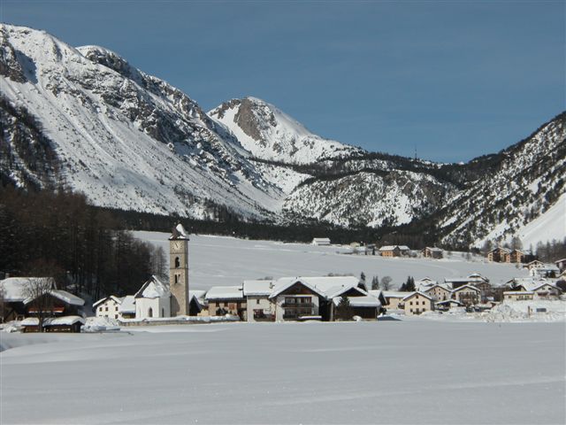
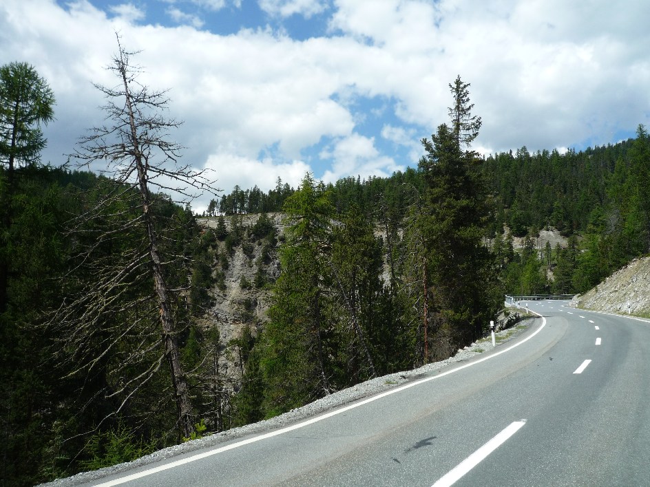
There are, however, a number of Nordic stations along the Pyrenees, such as Cap del Rec, Sant Joan de l'Erm, Abodi and CIVO and several other well known venues have plenty of Loipe, such as Piedra San Martín and Pla de Beret. Only one Nordic station in Spain is suitable for this series, however, and that is the Estación de Esquí Candanchú, a little way beneath the Puerto de Somport in northwest Aragón.

candanchu-esqui.jpg


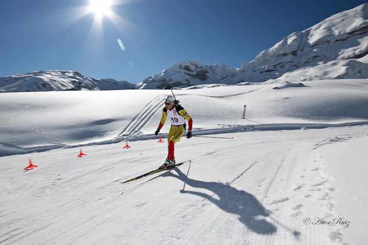
The Spanish side of the Puerto de Somport forms a stylized crucifix, with the road up to the pass leading from the south, ultimately from Jacá via Canfranc-Estación, with two ski resorts branching off close to one another, Candanchú to the left and Astún to the right. Named after a Castilian/Aragonese bastardisation of the original French "Camp d'Anjou", there are 35km of trails along with some Alpine pistes. Candanchú is unique in being the only Spanish venue authorized for international biathlon competition, although it has only hosted trade games such as the Military championships before, no IBU-sanctioned events.

candanchu-biatlon-gr.jpg


They do, however, host the national championships (aka the "how much can Victoria Padial Hernández win by this year? championships") annually on their wide open, sunny trails.

Biathlon%20Candanchu%20(40).jpg


However, the reason for picking up on Candanchú is because unlike anywhere else in Spain, a real international competition in XC skiing has rocked up into town, when Jacá - the city which brands itself Spain's wintersport capital and has tried to host the Winter Olympics on several occasions unsuccessfully - hosted the Winter Universiade, in 1981 and 1995. Biathlon was not part of the program on those occasions, however XC skiing was, and the courses in the venue had the chance to show that Spain has the facilities for an international cross country venue, albeit limited compared to some of the sites I've used thus far. And indeed, realistically the site doesn't merit looking at ahead of some others on the basis of what opportunities it gives or its wintersport heritage, however it is the only site the Vuelta could use that I will handle, so I've looked at it quite early on.

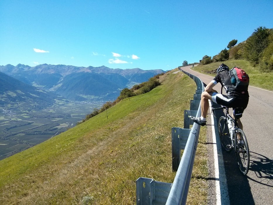
Perhaps because of its fairly benign nature, the Puerto de Somport is surprisingly underused in the biggest races. The French side is the more challenging, with the last 9km averaging nearly 7%, but it's still hardly a monster. Compared to the Spanish side, though, it's very selective, as the plateau with Jacá and Sabiñánigo sits on a ridge intermediate in altitude between the plains of Aragón and the Pyrenees, leaving a fairly unthreatening-looking ascent which doesn't become potentially decisive until quite late on.

Somport2.gif

Somport.gif


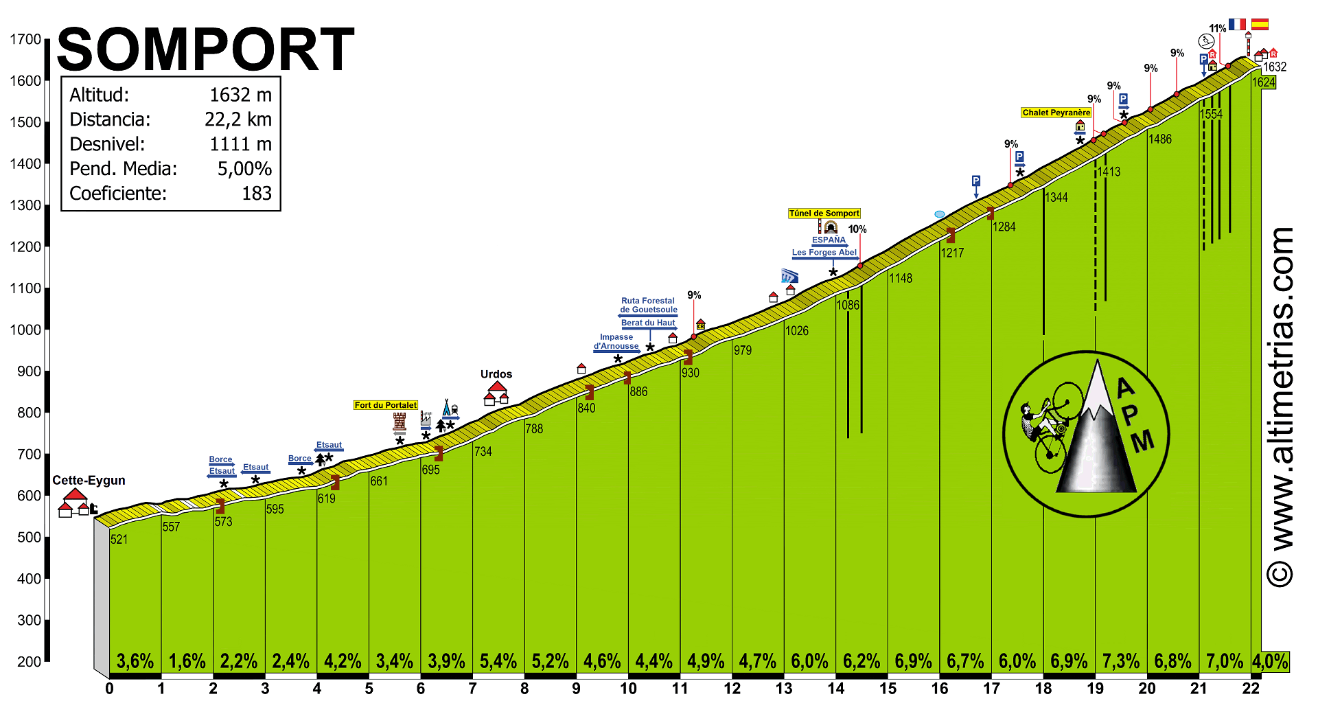
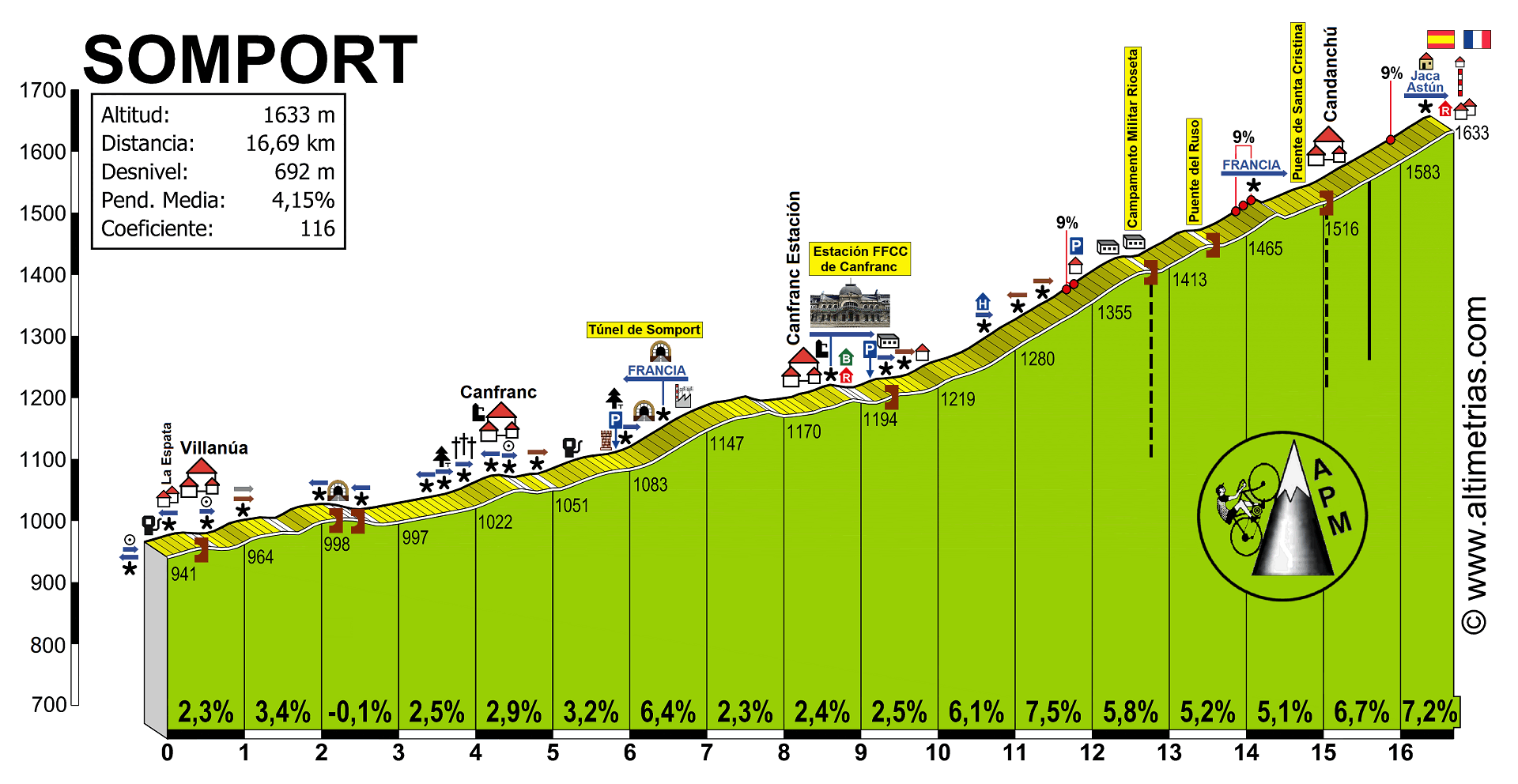
As you can see on the Spanish side, there's a junction for Candanchú at the 26km mark, whereupon we can turn off to the left and undertake a final ramp up to the line of 1,5km at 5,0% - divided into 700m at 7% reaching a max of 14%, then a flattening out as they cross the river, then the final 600m at 6%. Nothing like enough to break a field apart but an interesting little finale if riders come to it together - which they may well seeing as the previous climbs are hardly monstrous. Somport has surprisingly only been seen twice in Grand Tours, once in the Vuelta (in 1957, with the Portuguese José Ribeiro first over the summit early in a 250km stage from Huesca to Bayonne), and once in the Tour (in 1991, in the first Pyrenean stage from Pau to Jacá, with Leblanc first over the climb and Mottet winning the stage, which you can see here). The nearest we've come to a stage finish at Candanchú, however, was in the 1998 Vuelta, when a transitional stage from Benasque finished at Canfranc-Estación, partway up the Puerto, which was the site of Gianni Bugno's last pro win, from the breakaway as the péloton, tired from being put to the sword by José María Jiménez on back to back mountain stages, allowed the escapees to prevail. This may not always be the case though - the station has become somewhat united with the neighbouring Astún station (predominantly Alpine) and was purchased by Ibernieve Aragón in 2016 with the intention of bringing it into the Aramon group of ski stations - this would then give it common ownership with Cerler, Formigal and Valdelinares, which are established names in the Vuelta's lore.

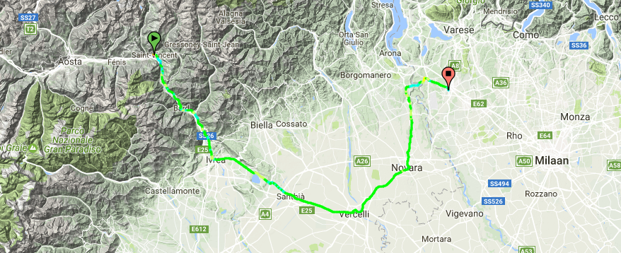
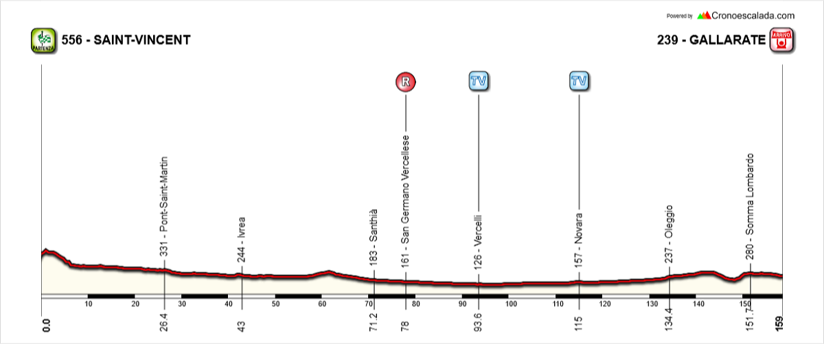
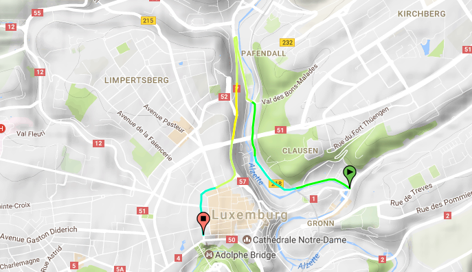
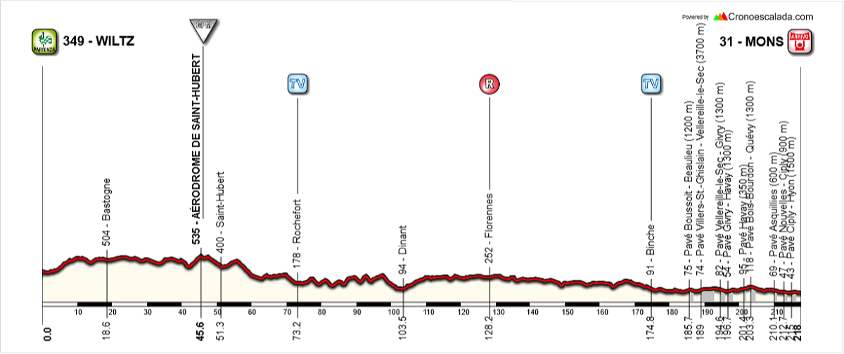
Stage Proposal #1: Sangüesa - Estación de Esquí Candanchú, 142km

10ol4pc.png


The biggest problem facing Candanchú from a racing point of view is that it is not ideally placed for decisive timegap racing. This is probably about the hardest stage one could present from the Spanish side of the climb, and it's hardly the most monstrous of stages, with all of the preceding climbs cat.3. However, of course the Vuelta has on two occasions in the past 5 years managed to produce its most epic racing on the least anticipated mountain stages, stages which were to shallow gradient MTFs thought of as rather pointless and not adding anything to the race. How wrong we were.

Vuelta2012perfil17.jpg


Yes, although my stage has several additional early climbs, these can all be added to or subtracted from to the designers' choice - I have gone for the "all-in" option here, but apart from the last two climbs before the MTF, each climb can be included in isolation or excluded entirely. Fuente Dé was a longer stage than mine here, however Formigal in 2016 was shorter. The question then comes on how to pace it to give these stages a chance to work. Here, this could only come after a key GC stage (either a TT or an MTF, which would have to be either in Navarre or La Rioja to work, so probably Moncalvillo or San Miguel de Áralar most likely) or a rest day. It is difficult, however, to predict or design to create the kind of racing that we got from those two stages, as they are somewhat anomalous in the recent history of the sport.

Stage proposal #2: Bayonne - Estación de Esquí de Candanchú, 211km

2rfq78j.png


Far more fruitful is to come from the French side of the Somport, which would then leave us with a short descent + mini-climb finish that's like a super-easier version of the Peyragudes finish via Peyresourde, the Vernoux-en-Vivarais finish from the 2011 Paris-Nice, the Lac de Payolle finish in the 2016 Tour de France or maybe Xorret del Catí. Arriving before Somport from the north would give us a Unipuerto stage, which would be regrettable, while coming from the east would entail the easy side of Marie-Blanque. The west gives us stronger choices, of which I feel this is the best, although in reality I think it much more likely that organizers would choose to go over the better-known Soudet and only do one of the climbs preceding the finale rather than do both the western and northern faces of Soudet but only as far as lesser summits.

18362dd4e0eaef58d4438ff0aa41d1b6o.jpg


Back in the El Correo-El Pueblo Vasco days, Bayonne was a regular Vuelta stop-off owing to its secondary role as the de facto capital of Iparralde, the northern Basque provinces, but realistically a stage like this, where all but the last 5km are in France, is fairly unlikely - though we did have the Aubisque stage which left Spain after just 1km, or the Fuentes de Oñoro stage of the Vuelta a Castilla y León a couple of years ago which returned to Spain from Portugal only 800m from the line. Perhaps more realistically the riders could start in Dantxarinea like in the 2016 race, or maybe even from Pamplona and arrive at Saint Jean Pied-de-Port via the easy side of the Puerto de Ibañeta.

The two key climbs in the stage are made up of constituent parts of other climbs. The climb to what I've marked as the Col d'Issarbe but potentially also known as the Col de Hourchère or the Station d'Issarbe consists of this profile as far as the Col de Suscousse, followed by climbing the 4,5km downhill section of this side to Issarbe before descending the left hand side of that profile into the intermediate sprint. There's then the steepest climb of the day, 9km @ 9% from La Mouline to the Col de Labays on this route, before a two-stepped descent and a long and gradually turning-up-the-wick climb cresting just 5km out. The inspiration behind this stage in design is routes like the 2011 Galibier stage when Schleck went crazy from distance, or the 1999 Piau-Engaly stage won in great style (well, in great guts and guile - nothing the man did on the bike could be considered stylish) by Fernando Escartín. There would also be great similarities to an earlier mountain stage in the 2012 Vuelta, the Cuitu Negru stage, only my comparison would be more suited to a finish at the Puerto de Pajáres, a much more traditional venue than Cuitu Negru, which follows in a line of Asturian MTFs that have been included then promptly forgotten about (Coto Bello, Ermita de Alba).
 
Tirreno-Adriatico Stage 5: Amatrice - Sant'Angelo in Pontano 188.5km
yvNxq2F.png

2p7BVa0.jpg


Stage 5 is the first of the three stage Marche odyssey. It is probably the hardest, too. This is a seriously tough stage, with over 4000m of climbing on very steep and narrow roads.

It starts in Amatrice, home the Amatriciana sauce, which is actually in Lazio. Following a theme of this tour, it was also one of the towns hit by the successive earthquakes of 2016. But we stay in Lazio for a very short time. After a bit of flase flat, we enter le Marche and the first climb of the day, a relatively benign cat 2 with a pretty steep descent. Another false flat follows and we pass both of the TVs on it on our way to Ascoli, where the second one is. Here the riders hit the only cat 1 of the day and only the third of the whole tour, Monte Girella/San Giacomo.

Ascoli_Piceno.jpg

Ascoli

After the descent comes the section in which the pace will undoubetdly pick up. It will really hurt some of the riders, as it is 20-30km of not steep but very rolling gradients, without much respite bar one or two descents which serve to do little else but break any rhythm they might have had. They pass a cat 3 climb, and following the descent there should be 35km of action.

The first of the quartet of climbs is also the hardest. Montefalcone is seriously hard - 4.3km at 9.6%, and will for sure force some attacks. There is no respite on the narrow climb, with no kilometre underneath 8.3%. The next climb starts off quite nicely, and is only 3.9km at 7.2%. However, the last 500m are on a very narrow road with gradients above 15%. This will act as a springboard to more attacks, or just as a selection as the front group is whittled down. After a short descent, the next climb again is a difficult steep grind, being 4.6 Km at 8.1%. This will probably not have that many attacks on it if we have had some already, which hopefully there would have been, but I think will just tire out any legs before the final climb.

WK06EFm.png


The final 5km are shown above - the main body of the final climb (until the short descent) is where the categorisation takes place, is about 2km of fairly steady 7.5%. This isn't overly hard, and as we found out at this year's race, isn't hard enough to drop Sagan. Therefore, if you want to win and cannot outsprint Sagan, you will have to attack well in advance of the final 4km. Ignore the last 100m of descent, the stage actually finishes on the slight uphill drag, that's just an error on my part. Hopefully we will be in for another slow-mo sprint or a solo finish.
 
Tirreno Adriatico Stage 6: Camerino - Porto Sant' Elpidio 212.1km
UA1h88w.jpg

A9aeRzn.jpg


The second tappa marchigiana begins in Camerino, and quickly deals with Crispiero, the same climb which featured in 2015 when Poels won solo ahead of a dozen or so strong group led by Uran. There are two fairly significant climbs over the next 50 or so kilometres before the very hilly and bumpy section begins. There is less climbing than yesterday, but it is still substantial, over 3500m.

However, the stage shouldn't really blow up until the last 45km, where they take on Sant' Elpidio al mare with the infamous 27% slopes. After a descent, the riders take on the easier Montegrano, before taking on the final stretch of the previous climb - the 27% section. But that isn't the last time it will be climbed, as the climb is redone in full and crested 10km form the line. I have no doubt that this stage will finish with small groups, but I do not know when the action will begin. Legs will be tired after yesterday and the day before, so perhaps that will take a toll. Tomorrow is simple, so riders shouldn't fear it.
 
Tirreno-Adriatico Stage 7: Porto San Giorgio - San Benedetto del Tronto 132km
IVjNHvR.png

JH4719q.jpg


The last stage is one for the sprinters. They haven't had many opportunities, apart from the stage into Florence which probably was one for the puncheurs as it finished on the 2013 circuit, and one into Sassoferrato which is for the very durable sprinters, like Colbrelli or Matthews. This one I have tried to make it resemble Milano-Sanremo fairly closely, to tempt them into coming to the race. Obviously it isn't even half the length, but hopefully the past 6 days and the extra hilliness that start of this stage offers makes up for some of that.

The first climb is pretty serious, contaning a 2km section at well over 10%. However, it should be for the break and not much else, as it is nearly 100km from the finish. The race is pretty easy thereon until after the 100km mark, where the final climb of the day begins. It is pretty easy, only 7.3 Km at 4.5% which roughly compares to the Poggio, with 3km added on. There is a 500m section at over 7%, so it does stiffen up a bit like the Poggio too. The similarities end there, as the descent is pretty easy and the finish has been extended with a very flat and very straight 13km circuit.
 
Tirreno-Adriatico Summary

Stage 1: Livorno-Livorno ITT 36.9km ****
IaoEA7s.png


Stage 2: Montecatini Terme-Firenze 189.7km ***
ArtSoDa.jpg


Stage 3: Arezzo-Sassoferrato 207.1km ***
KtysOxl.jpg


Stage 4: Fabriano - Norcia 161.5km ****
VPnsGsz.jpg


Stage 5: Amatrice-Sant' Angelo in Pontano 188.5km *****
yvNxq2F.png


Stage 6: Camerino-Porto Sant' Elpidio 212.1km ****
UA1h88w.jpg


Stage 7: Porto San Giorgio-San Benedetto del Tronto 132km **
IVjNHvR.png
 
What is the most height meters it's possible to pack in one stage assuming a stage with reasonable length? I've done some experimenting, and the "worst" I could come up with, was this:

EClDoz0.jpg


233 km from Bolzano to Tre Cime di Lavaredo with 11 climbs. About 8000 meters of categorized climbs:

Obergummer
Passo Costalunga
Passo San Pellegrino
Passo Valles
Passo Rolle
Passo Cereda
Passo Duran
Forcella Staulanza
Passo Giau
Passo Tre Croci
Tre Cime di Lavaredo

Is it possible to come up with something worse?
 
According to Openrunner Mazzo en Valtellina - Passo dello Stelvio (Mortirolo, Monte Padrio, Forcola di Livigno, Passo d'Eira, Passo di Foscagno, Umbrailpass, Stelvio) is 226 km long with 8318 height meters. I think thought that it should be possible to get even more altitude gain on 230 km in the Dolomites. And I think the stage suggested by rghysens has more altitude difference as well.
 
Gigs_98 said:
According to Openrunner Mazzo en Valtellina - Passo dello Stelvio (Mortirolo, Monte Padrio, Forcola di Livigno, Passo d'Eira, Passo di Foscagno, Umbrailpass, Stelvio) is 226 km long with 8318 height meters. I think thought that it should be possible to get even more altitude gain on 230 km in the Dolomites. And I think the stage suggested by rghysens has more altitude difference as well.

I tried to create that stage on crononescalada. I got something like 216-217 km and 7700-7800 height meters. Well, at least the altitude difference of the categorized climbs.
 
Speaking of that particular combination of climbs (Gigs' combos including Livigno, Stelvio, Umbrail etc.)...

Nordic Series 7: Val Müstair

One of the less populated hidden corners of Switzerland, the mostly Romansch-speaking Val Müstair municipality consists of a sequence of villages along a narrow valley in a remote southeastern corner of the country. Known in German as Münstertal and Italian as Val Monastero, it is connected to the rest of its homeland only by the 2149m Ofenpass/Passo del Fuorn, and when the pass is inaccessible the valley can only access the rest of Switzerland by way of heading eastwards over the Italian border to Mals and then northwards through Austria over Reschenpass! With a population of only around 1500, it's a very small place to be hosting any level of international sport - but then the region has one - just one - famous son.

That son is Dario Cologna, a prolific cross-country skier who has won the overall World Cup four times, three Olympic and one world championships gold medal, and the Tour de Ski three times. In fairness, his brother Gianluca is not a bad international cross-country skier either, but has struggled to get out of his older sibling's considerable shadow. As a result of his success, the valley has rather looked to connect itself with cross-country skiing, rather than have those who would follow in Dario's footsteps have to travel all the way over the pass to St Moritz, Pontresina or Davos should they want to pursue such a career, or travel into Italy to the school at Mals, they wanted to bring skiing to Val Müstair.

val_muestair_s12.jpg


As you can see, the valley is scenic, but the problem that the prospective race organizers had is that other than on the passes themselves, the altitude isn't actually that high and so guaranteeing the right amount of snow for lengthy courses could be problematic. The problem was solved in two ways. Firstly, the Val Müstair consists of three plateaus between the Italian border and the final few kilometres up to Ofenpass. Unusually for a valley these aren't denominated "upper" and "lower" but instead "inner", "middle" and "outer". Secondly, short courses perfect for sprints may be an issue for holding a whole race weekend - but they could be perfect for stages of the Tour de Ski, with good possibility to link to the Val di Fiemme, Oberstdorf, Lenzerheide and other prospective hosts. Plus, of course, the stage racing format was one that Dario made his own until the last few years when Martin Johnsrud Sundby has been unstoppable at least. With wide open, flat spaces and a sizable parking area to enable traffic to rest up after or before the Ofenpass, the small village of Tschierv, at the upper end of the valley, was perfectly placed to capitalise, and a course was duly designed and arranged, which you can see here.

34377fb97b.jpg


The location of Tschierv's ski venue is absolutely ideal for cycling, because options are myriad. Here is the profile of the Passo del Fuorn taken from the Italian border rising through the Val Müstair:

OfenE.gif


So - your choices are to arrive with a short sharp descent from the other side of the climb (which can be a small climb if taken from the Livigno road, or an interesting double-climb if taken from Zernez, as it entails the mid-sized Ova Spin climb, then a descent, some false flat and finally a punchy climb to the summit), or an Aprica-esque finale on a shallow climb but located well to connect it to at least one legendary monolith of a climb. As an even more enticing alternative, now that all of Umbrailpass has been paved, there's the option to descend the Swiss side of that beast - which deposits you in Santa Maria di Val Müstair and provides you with a climb equivalent to kilometres 14 to 6 on that profile - rather like an easier version of the Ridnaun finish I dealt with earlier in the series. The options available here really offer a lot, and as a result there are quite a few different stage options I've explored here.

Villa_Kuntner_Bund_Aussicht_1(1).jpg


Stage proposal #1: Vipiteno-Sterzing - Tschierv in Val Müstair, 163km

5esaa9.png


This is not the most brutal stage that would be possible in the area, by far, but it still has plenty to recommend it. Firstly, we start immediately from Vipiteno-Sterzing, which brings in possibilities to come off the back of a Ridnaun stage anyway, unlikely as it may be. Secondly, there's no easing into the day with this stage at all, we go immediately onto a cat.1 climb on the Jaufenpass, an enormous and threatening summit which will ensure only those with strong legs get into the breakaway, before a long and technical descent. There's then a long period of valley roads - the linking of Sankt Leonhard in Passeier to Merano is the one problem with this part of Italy before we enter Val Venosta, better known by its Germanophone name, the Vinschgau. To toughen up this part of the stage I've unearthed a nice little cat.2 (Giro standards) climb to break up the rhythm. And it's picturesque too.

Stilfserjoch074.jpg


There are many "Höhenstraße" roads in this part of the world, connecting mountain villages via a long, sinewy trail that bears some, but not massive, resemblance to the passage of the valley below. The Vinschgauer Höhenstraße is 8km @ 8% with the first 5km averaging almost 10%, but it barely registers on the stage profile, mainly as after the descent, just 5km of flat takes us to the village of Prato allo Stelvio, and we all know what that means.

prato-allo-stelvio-passo-dello-stelvio-muestair-bici-da-corsa.jpg


Stelvio's eleventy-billion hairpins from the much-loved Prato side amount to an almighty 25km @ 7,2% and - inevitably - the Cima Coppi. Descending via Umbrailpass also gives us a steep and tricky descent that the péloton at this point are unlikely to be familiar with, so in addition to the special attraction of the ceiling of the Giro you also have only 25km remaining to the line at the summit, so all the more incentive to make it count. The descent arrives in Santa Maria di Val Müstair, therefore we have the 2km at 8% hidden by mostly false flat in the uncategorized ramps to the line.

Stage proposal #2: Clès - Tschierv in Val Müstair, 131km

24e6s80.png


With the current fad for short-distance mountain stages gathering pace, this is a drama-packed short stage that takes some inspiration from the 2004 Bormio 2000 stage which was the final stage won by Cunego in that notoriously bad edition of the race. To be honest though: nothing wrong with this stage design, which had three tough mountains with the hardest one in the middle and the Cima Coppi available too. I just wish it had been longer and included Mendelpass first. So yes - the start of this stage is all classics all the time, with Tonale and Gavia, and of course the stage would be best suited if the Passo di Gavia were to be the Cima Coppi; most years that it is included, of course, it has that distinction, with only Stelvio of classic Giro hosts coming in at a higher altitude. Here, of course, we could go the Stelvio route, like the aborted 2013 stage and subsequent 2014 stage to Val Martello - but it's better instead to proceed over the summit of Umbrailpass and descend into Val Müstair like in the first proposal above. At 18km @ 7,1% even though this is the less steep side, the Passo dell'Umbrail is more than tough enough to make a difference, and it crests just 21km from the line; even better is that by avoiding going over the Stelvio, unless they use it in the following stage (I would recommend going from Malles Venosta/Mals towards Merano and over to the other side of the Dolomites that way), then the Gavia is likely to be the Cima Coppi, coming 62km from the line and giving us likely two climbs that will provide at least some fireworks before the same frantic descent and short lip of a climb up to Tschierv that was included in my first proposal.

Stage proposal #3: St Moritz - Tschierv in Val Müstair, 160km

iz9m2w.png


This is the first of the stages that could be both a stage of the Tour de Suisse and the Giro d'Italia, an intermediate stage which starts and finishes in Switzerland but spends the majority of its duration in Italy. It would be well placed off the back of a mountain stage either into somewhere in Switzerland (Splügenpass - Albulapass - La Punt please!!!) or somewhere like Madesimo (off the back of San Marco!). It utilizes only relatively small climbs and the easier side of the Passo Bernina, but is still quite a tricky one to negotiate for the GC men. As climbs out of Bormio go, the doublette of Foscagno and Eira is not the most legendary by any means, but 15km at 6,4% is still a tough obstacle in anybody's language. Finishing with 44km remaining, this is where I see the breakaway - for I anticipate this would be a stage for them - imploding, although maybe not as much as in the great 2005 Livigno stage won by Iván Parra. After the short rise of the Passo d'Eira immediately following, the riders descend into that popular altitude camp and climbing base, Livigno, for an intermediate sprint and a brief period of flat, before two long tunnels at the border between Italy and Switzerland, and then doing the final 8km of this two-stepped side of the Passo del Fuorn:

OfenW.gif


Cresting just 6km from the line, with the descent running all the way to the stripe, there will surely be a level of urgency in this climb, what with the last 1500m averaging 9% and offering the chance for punchier GC riders to distance some of the more diesel types without expending that much energy - therefore incentivizing it more compared to many intermediate stages that come preceding high mountains. And in the Tour de Suisse, this could be an interesting stage to set up a final battle over neighbouring climbs like Flüelapass, Albulapass, Lenzerheide and Arosa.

Stage proposal #4: Sondrio - Tschierv in Val Müstair, 170km

300scxw.png


Once more we return to the descent of the Umbrailpass for the short final climb via Santa Maria di Val Müstair, but instead of coming over the Gavia or Stelvio, we're utilizing a few of the less celebrated climbs, including doing a large part of the third proposal in reverse. The inspiration behind this stage largely comes from the final mountain stage of the epic, legendary 2010 Giro, from Bormio to Passo Tonale over Livigno, Eira, Foscagno, then the Cima Coppi at the Passo di Gavia and the MTF at Tonale. Now I can't guarantee that this stage would have the Cima Coppi - although at over 2500m the Passo dell'Umbrail (which has never had the honour in the past) would be a more than justifiable ceiling for the race; however as I've taken away the difficulty of the MTF, I've elected to approach from the other direction in order to bring in the steep opening climb of the Valico di Trivigno.

However, the mighty Forcola di Livigno is pretty underrated - considering that 2010 stage is the only record kept of its Giro presence, when Matthew Lloyd won the climb to protect his lead in the GPM and, worse, the only remaining challenger for it, Xavier Tondó, crashed out of the race on the pseudo-descent (there really isn't much of one). Recharging in Livigno then gives us the one-two punch of the smaller climbs before we descend the Foscagno by the route we climbed in the last stage, via the town of Valdidentro, which also has its own XC skiing and biathlon venue that I may tackle at another point. From then it's as per stage 2 - Bormio intermediate sprint, and then the 18km @ 7,1% climb up to Passo dell'Umbrail and the difficult descent into Val Müstair.

Stage proposal #5: Darfo Boario Terme - Tschierv in Val Müstair, 203km

2py5c13.png


Here we depart a bit from the template when approaching from the expected classic passes with a stage approaching from the south but not arriving in Val Müstair by the routes used above. Instead here we use the fuller extent of the climb up to Ofenpass to maximise that "Aprica" feel in the stage design. The stage approaches the classic climbs from the direction of Darfo Boario Terme, which would suggest that the stage would be best coming off the back of a climb to Monte Pora or, more likely, Pian del Montecampione, because a stage with both Gavia and Stelvio is likely to discourage attacking in the preceding stage, so a killer MTF with 20km at 7,5% will be the ideal way to set it up, because time gaps will be generated just by the difficulty in general.

Obviously we've seen the Gavia-Stelvio combination rode together in racing just the once before, in 2014, after the 2013 stage had to be aborted due to the weather. And even then, harsh weather threatened to ruin the stage, and created major controversy that reigns over the day's racing to this day. Of course, in my stage we don't have the same major MTF but the weather will still remain a risk, going over 2600m on back to back climbs. The Stelvio will inevitably be the Cima Coppi, however here due to the nature of the stage it actually comes some 80km from the line - hence this would be best served as the final mountain stage, with nothing left to lose. Alternatively, as you'll know from proposal #1, there's only 5km between the base of my penultimate climb, which is the Vinschgauer Höhenstraße, and Prato allo Stelvio, so if the organizers were afraid that the distance to the line would kill action on the Stelvio and make the Cima Coppi a less coveted prize than usual, they could always revise the stage accordingly; this would essentially expunge everything from km 151 to 180, moving Stelvio to 51km from the line. Personally I like the idea of incorporating a smaller but unknown climb to almost surprise the riders before the inconsistent but unthreatening final climb.

von-tanas-zur-koepfelplatte-wanderung-laas-vinschgau-suedtirol.jpg


Stage proposal #6: Vaduz - Tschierv in Val Müstair, 124km

fu3qzc.png


The short mountain stage curse strikes again, with a 120km stage which could make an ideal finale for the Tour de Suisse, off the back of an MTF at (preferably) Malbun. It's much less likely for a Giro although I've used the Giro profile style - that said, starting somewhere like Mandello dello Lario or Morbegno and going over Splügenpass and Lenzerheidepass wouldn't make a Giro stage to Malbun an impossibility - however highly unlikely. A shame though, I am a fan of the Lichtenstein MTF and would like to see it come back some time. Anyway - this is a stage that could come off the back of it, and it works the short mountain stage formula, with much of it offering the possibility that something could happen but without looking especially threatening. It also enables me to use the full extent of the Engadin side of Ofenpass, with both parts.

Ultimately, although Wolfgangpass is a decent enough climb in and of itself, it's essentially a stopping point and plateau on the way up to Flüelapass, stopping for a loop around the legendary skiing town of Davos (I'll almost certainly cover Davos at some point) before continuing up to the summit. The Davos side is a little easier with fewer monster gradients, but as the major climb of a short day in the saddle, cresting 46km from the line, you might have to make it count. It's the opposite side from the last time we saw it, in last year's Tour de Suisse, of course, but that does mean you will have seen the Susch side being climbed - and will therefore be aware it makes for a tricky descent into the Engadin valley. After moving onto Zernez we then get to see the full extent of the western side of the Ofenpass posted above.

Anstieg%20Ova%20Spin.JPG


The first 6km or so average 7% and make for a lower category climb of their own, cresting just over 20km from the line at the crossing of the Ova Spin dam before a slight downhill. There are around 10km of uphill from the end of that descent to the summit at the Passo del Fuorn, but most of these are shallow, with one medium section giving way to false flat before the steep kick up to the summit which, as with the earlier stage, is only around 6km from the line, all of which is downhill.

Really, the possibilities are myriad in Val Müstair, and the main issue therefore is not the logistics of bringing the sport in, but just the justification to a population that only has the connection to one sport - cross-country skiing - and hasn't seen GT racing since the 1995 Giro stage to Lenzerheide. As a corner of Switzerland only accessible via one pass or at least one separate country, it's gone rather hidden away from cycling for long periods, but there are more than a few opportunities to put that right.
 
Giro d'Italia prologue: Luxembourg (LUX) - Luxembourg (LUX) (4,3 km)

Yes, I'm taking the Gran Partenza to a country far away from Italy. That's because I do like such GT starts, because it gives small countries the possibility of having a GT too. In fact, the only time I've watched at a cycling race live was at the Giro 2010 (I live in The Netherlands). So, that's why I go with Luxembourg now. Luxembourg has never had a Giro start, but the Tour started there 3 times (1989, 1992 and 2002). Cycling is the biggest sport of Luxembourg, already since the 1900s (François Faber winning the 1909 TdF). Many people in the country could like another GT start.

The Giro starts in the capital, Luxembourg, with a short prologue of only 4 km. The first part is flat, alongside the Alzette river. After 2,2 km, a small climb starts, which makes the stage not one for the pure time triallists. The climb is 1,3 km long at 4,8% average, so it should be relatively easy. At the top, it is just 750 meter of flat road to the finish line. Most time trial specialists are at least decent in hills, so they should contest the win. However, a really good hill rider could surprise.

Viyh2a5h.png

244e0RkC.png
 
Giro d'Italia stage 1: Wiltz (LUX) - Mons (BEL) (218 km)

Stage 1 of this Giro starts in Wiltz, a town in Luxembourg with 6200 inhabitants (2015). From there, it's not far to the Belgian border. The riders enter Belgium and go through Bastogne, known as the midpoint of Liège-Bastogne-Liège. A bit later, the riders will do the first and only categorized climb of the day. The top is near the Aérodrome de Saint-Hubert, so that's what the climb is named after. After the descent, the riders pass through the village of Saint-Hubert. The first intermediate sprint of the day is in Rochefort, after 73 km.
When the riders leave Rochefort, a hilly zone starts. The impact on the stage should be minimal, however, because it's very far from the finish line. The riders also pass through the very scenic town of Dinant. The feed zone is a bit further on the route, in Florennes, a town with a castle dating from the 10th century. The route then goes through some small villages, until the second intermediate sprint of the day in Binche.

11 kilometers after passing through Binche, the real fun starts. The riders leave the village of Boussoit and get confronted with this. Yes, we're having a cobbles stage in the Giro, already on day 2. The riders will have to face a total of 12,1 km of cobblestones. I've found these sectors myself on StreetView. Some of them might be used in Le Samyn, which also takes place in this area. Anyway, the first sector is neither really easy nor really hard, and 1,2 km in length.

The second sector of the day doesn't start long after the first one. However, it is by far the longest of the day at 3,7 km (just as long as Quiévy - Saint-Python, the longest sector of Paris-Roubaix). It is of average difficulty. The third sector of the day is an easy one, 1,3 km of this. After a short asphalted passage through Givry, the fourth sector of the day starts, which is 1,3 km long, just like the previous one, but a bit harder.

There is a relatively long stretch of asphalt (3,3 km), before a very short, narrow section of cobbles (the riders come from the other direction, but there's no StreetView at that side). It's only 350 m long. However, this is just the preparation for what comes next. Say hello to the Secteur pavé de Bois-Bourdon à Quévy (as the ASO would call it. I've RCS-ized it to Pavé Bois-Bourdon - Quévy). 1300 meter of hell-like cobbles. Some parts even have grass in the middle. This sector will be decisive.

Fortunately for the riders, they can recuperate on a 5 km-long asphalt stretch. Then the finale begins with 2 short sectors, Asquillies (0,6 km) and Nouvelles - Ciply (0,9 km). The final sector is the Rue des Canadiens (1.5 km), already within the city borders of Mons. Its cobbles are easy, but as you can see, there are these obstacles on the road, normally meant to slow cars down, but in a cycling race, they would provide a technical challenge (though they would probably be temporarily removed for improved safety). (Un)fortunately there is an asphalted bicycle lane at the left side of the road for about half of the sector.

The finish is just outside the center of Mons, on the Avenue d'Hyon. The length of the stage may also play a role, because a 218 km stage on cobbles isn't really what you call easy.

Climbs:
cat. 4, Aérodrome de Saint-Hubert (3,6 km @ 4,5%)

plXnpWN6.png

71UO5PlA.png
 
Last edited:
Giro d'Italia stage 2: Waregem (BEL) - Eindhoven (NED) (209 km)

The third stage will take place after a short transfer that takes the riders from Wallonia to Flanders. The start is in Waregem, almost exactly in between Gent and Roubaix. Early in the stage, the peloton passes through the towns of Merelbeke, Wetteren and Dendermonde.

Halfway the stage, the riders visit Lier. The feed zone is not much further, in Zandhoven, not much to say about that village. The first intermediate sprint is near the Dutch border, in the town of Hoogstraten, which also hosts a cyclocross race annually. The riders then enter The Netherlands, but they'll pass through the village Baarle-Nassau, which hosts a number of Belgian exclaves, which make up the Belgian village Baarle-Hertog. Read more about it here. The second intermediate sprint of the day is on Dutch soil, in the town of Goirle (very close to Tilburg). From there, the route takes a mostly straight line to Eindhoven (my hometown ;)). The finish is at the Philips Stadion, the stadium of football/soccer club PSV.

The stage is 100% flat, hard winds are rare in this area so a bunch sprint is very much expected.

Climbs:
none

GcZGKgTP.png

pH2gsiZq.png
 
Giro d'Italia stage 3: Ventimiglia - Acqui Terme (192 km)

The riders will have an early rest day, used for a plane transfer from Eindhoven to Nice. From there, they will go to Ventimiglia by car, where the next stage starts. Already after 16 km, a famous place in cycling is passed, namely San Remo. It's of course the finishing town of Milano-San Remo, but the Giro also occasionally visits it. The route follows the Italian coastline, going through scenic cities and towns like Imperia and Albenga. The first intermediate sprint is in Pietra Ligure, followed by the feed zone in Spotorno. After the second intermediate sprint in Savona, the beautiful pictures are over as we head away from the sea.

The first climb of the day is an easy one, the Bocchetta di Altare which is partially just false flat. Despite its length, it is categorized as cat.3. There is no descent, just a stretch of false flat downhill for 40 km. With 22 km to go, the final climb of the day starts. The climb to Montechiaro d'Acqui is 4,8 km @ 7,1%, here the stage will likely be decided. After the point where the KOM points are given, it's a few irregular kilometers until the descent begins. The descent is technical, with 9 hairpin bends and the road is narrow. From the end of the descent it's 7 km of flat roads to the finish line in Acqui Terme.

Climbs:
cat. 3, Bocchetta di Altare (12,0 km @ 3,6%)
cat. 3, Montechiaro d'Acqui (4,8 km @ 7,1%)

V1aJYfIg.png

tRX1ebbB.png
 
Last edited:
Giro d'Italia stage 4: Acqui Terme - Turin (164 km)

The fourth stage (excluding the prologue) starts where the previous one finished, in Acqui Terme. Immediately after the start, the road goes uphill, but this climb belongs to the neutralized part of the route. The first city that will be passed is Nizza Monferrato (this is the best picture I could find). From there, the route heads to the west and passes through Alba after 52 km. The next city on the route is Bra (no picture this time).

Almost exactly halfway the stage, the feed zone is located in Savigliano. The two intermediate sprints are in Saluzzo and Pinerolo, the latter being known as a regular Giro host. The finish is in Turin, or Torino as it is known in Italian. It is the largest city that this Giro will visit. The finish is on the Via Guido Reni, a 3-lane road in the neighborhood of Mirafiori Nord.

The stage is dead flat, again just a very small chance of crosswinds so it's time for another sprint.

Climbs:
none

Tu1Difch.png

MjM7qnQN.png
 
Last edited:
Giro d'Italia stage 5: Turin - Aosta (183 km)

On the sixth day of this Giro d'Italia, it's time for the first real mountains. And yes, it is in Valle d'Aosta. Coming from Turin, the riders will ride over flat roads first. The first intermediate sprint is in Cuorgnè after almost 50 km. Directly after, the first climb of the day (not in Valle d'Aosta yet) has to be faced. It's not a really hard climb at less than 5% average, but some domestiques could be dropped. The descent features a short uphill part. After the descent, it's a long flat section in which Valle d'Aosta is entered. The feed zone is in Donnas, just 11 kilometers later it's time to get serious.

The second climb of the day is the Colle Tzecore. It's a serious cat. 1 climb, with the hardest part near the end. The descent is technical and contains 17 switchbacks. Right after the descent, there is the second intermediate sprint of the day, on cobbles.

After some flat kilometers, the penultimate climb starts, it's probably never used before and there is no profile available. The climb goes from Chambave to Verrayes and is 6,7 km at 8,0% average. That's all I can say. The descent is part of the Col de Saint-Panthaléon, which has been used in the Giro before. After the descent - I regret it a bit - another flat section of around 10 km.

The final climb is also one never seen before in cycling, from Villefranche to Jeanceyaz. It's 8,1 km at 6,9% average, but in the beginning there is a small downhill section. The road is also a bit narrow sometimes. The final descent takes the riders straight to Aosta. In the final km, there is a double hairpin bend (although it's wide), which makes the sprint preparation a bit harder (if a group is still together by then).

Climbs:
cat. 2, Castelnuovo Nigra (9,9 km @ 4,7%)
cat. 1, Colle Tzecore (16,0 km @ 7,6%)
cat. 2, Verrayes (6,7 km @ 8,0%)
cat. 2, Jeanceyaz (8,1 km @ 6,9%)

oq7rKC70.png

7kOpfF9n.png
 
Last edited:
Giro d'Italia stage 6: Saint-Vincent - Gallarate

The Giro goes on with another flat stage. That means only one mountain stage in Valle d'Aosta this Giro, but still better than nothing. It's still the first week, so it better not be too hard. The start is in Saint-Vincent, a town with much Giro history. The Giro has started in Saint-Vincent 13 times, the last time being in 2015. Saint-Vincent was also the finishing place of the 1987 Giro, which ended with a 32 km time trial won by Stephen Roche, who also won the final general classification.

The riders leave Valle d'Aosta and go through Ivrea. Later on they pass through Santhià, shortly followed by the feed zone in San Germano Vercellese. The first intermediate sprint will be in Vercelli (not within the historical centre on the picture). After Vercelli, the riders turn to the Northeast. The second intermediate sprint is in the biggest city the riders will see today, Novara.

The route then goes north and passes through Oleggio. At Varallo Pombia, the route turns to the East and crosses the Ticino river. After the bridge, a small, uncategorized climb starts (1,7 km at 4,2%). The steepest parts are about 8%, so it's not a real challenge. However, it could be the base for an attack, as it's only 9 km to go at the top (there is no descent). It will be hard to stay ahead, because it's mostly a long straight road, starting from Somma Lombardo. The finish is in Gallarate.

Climbs:
none

6QmNXrBI.png

wr1yzzZx.png
 
Last edited:

TRENDING THREADS