Totally feel you on that one,
@jsem94, the research and writeup phase is the biggest handicap to regular posting here, as I've kept myself interested over the years more through that means than the original early point of the thread where it was "point A to point B, look at these roads". It's time for the next Vuelta - I’m afraid there’s quite the backlog of races built up, especially as researching one of them (one that I've been wanting to do for a long time, but have been prevented from doing so by the paralysis of choice) has sent me down the wildest, most bizarre rabbit hole yet, one that has grown so large it cannot go in the Race Design Thread as it’s far too off-topic but has run to absurd length (it's resulted in me writing, no joke, well over 10.000 words on the retirement of a pro wrestler I’d never heard of before December, and I’m willing to wager none of you have either) - but this one is slightly different as it comes with a
theme. Back in the early days of the thread I did a “trying to maximise Spanish geography” Vuelta which included both sets of islands (the Balearics and the Canaries) as well as the two largest African exclaves, and I did a Vuelta built around honouring the hometowns of as many legends of Spanish cycling as possible, but largely themes have been more identified around the focal regions or similar, whereas this time I’m attempting to resurrect a
style of Vuelta.
The current ‘era’ of the Vuelta sees its identity defined by ‘rampas inhumanas’, short and medium-length climbs that see double-digit average gradients and force gaps by that means. This very much traces its origins back to the 2012 Vuelta, and the runaway success that that - very much
despite its idiosyncratic route - proved to be, with a disappointing Giro and Tour that year, and marquee Spanish names who specialised over that very type of climb prevailing daily. ’Twas not always thus, however, and that Vuelta, though perhaps a reflection of a directional shift that had been ongoing for a couple of years prior, was very much a break from the tides of the previous era.
I am trying to design something that represents an innovative and creative reflection of a classic 2000s-era Vuelta design within the parameters of today’s cycling, what the Vuelta could look like if that era’s design principles and focuses had not been replaced by the post-2012 philosophy. But in order to do that, we must first understand what the Vuelta looked like in the 2000s. The race had seemingly finally found its home, having moved to September and become ingrained in the highest level of the world calendar; still the undisputed runt of the GT litter, its identity as a Grand Tour had finally been fully affirmed. Spanish cycling was stupendously strong; the aftermath of the investment in sport (and science) around the 1992 Barcelona Olympics still played a role, and nearly every region was sponsoring a team at some level. A combination of Operación Puerto uncovering the seedy underbelly and the global financial crisis at the end of the decade hitting Spain hard would change that, of course, but for most of the 2000s, there was a very strong Spanish presence, both in terms of the teams and riders, in its home race, without it sinking to the level of provinciality that had plagued the race during the El Correo-El Pueblo Vasco days. The 1980s and 90s had been relatively kind to the Vuelta, with Unipublic’s guidance bringing the race to a wider audience and establishing new iconography of the race during the long absence of País Vasco from the race’s routes.
There were two other factors specific to the 2000s as an era of the Vuelta that need consideration however. They actually both start in the late 90s but their impact was significant on the 2000s editions of the race. Firstly, the riders who contested it. Spanish cycling has historically prized the mountain goat higher than any other traditional cycling nation, and until the Colombians came along in the 1980s, when you thought of the home of wispy, unreliable, mercurial lightweight climbers, you thought of Spain - the country of Vicente Trueba, Julio Jiménez, Federico Bahamontes, Luís Ocaña, José Manuel Fuente and Pedro Delgado. However, the 1990s had brought a new class of Spanish contender to the table, via the influence exerted by the success and popularity of Miguel Indurain: the hulking diesel climber and time trial engine. The Vuelta would see a new class of post-Miguelón GC contenders emerge, Spanish riders for whom the mountains were secondary to the chrono, and who would tempo grind their way to the summits. Spanish GC contention would therefore see the likes of Abraham Olano, Ángel Casero, José Enrique “Búfalo” Gutiérrez, Aitor González, Isidro Nozal, Santos González and Igor González de Galdeano doing battle on behalf of the new wave of diesels against the likes of Fernando Escartín, Roberto Heras, Joseba Beloki, José María Jiménez, Carlos Sastre, Iban Mayo and Óscar Sevilla who would sate the demands of the old guard to retain some of the romantic idealism of Spanish cycling past and while they often carried more popularity than their more pragmatic brethren, the race tended to marginally favour the former.
The other factor was the route itself. The Vuelta had had to undergo a wholesale revamp of its general design in the 1980s, with the Basque region forced off the menu. Unipublic had sought to establish Madrid as a final home of the race, patterned after the Tour’s iconic Paris finale, and as a result the late stages of the race had developed to formula, with transitional stages around historic Castilian cities like Toledo, Ávila and Segovia before a dénouement in the Sierra de Guadarrama. New classic climbs like Sierra Nevada and Lagos de Covadonga had been added to the race’s lore to fill the void left by the classic Basque sawtoothed stages of the past. However, during the 1990s the race had become very formulaic as, in their attempts to rapidly establish lore and iconography around these climbs, these had become almost annual fixtures, and so the race route had become quite predictable. Simultaneously, the move of the race from April to September meant that the weather would inevitably be better, and widened the prospective opportunities for use of climbs especially at altitude. Not just Unipublic, but also the teams and riders themselves, along with enthusiasts and fans, were hunting out new climbs to add to the race, and with the early days of the internet as well, this is the genesis of the strong and vibrant traceur community in Spain.
But while the most iconic of Vuelta climbs introduced in this post-September transition may have been the most brutally steep - Anglirú of course being added to the race’s repertoire in 1999 - most of these were more what you’d call ‘classic’ types of climb, where their difficulty was more the product of sustained steepness for long distance than the product of inconsistencies or brutal ramps. There were some, of course - Xorret del Catí was introduced in 2000, and La Pandera in 2002 - but only the latter went on to regular use in the era (four appearances from 2002 to 2009 with only one since!), with even Anglirú taking a layoff from 2002 to 2008. The move of the race to September reducing the risk of weather-related cancellations in the Pyrenees made Andorran climbs safer inclusions; Arcalis (last 13,4km @ 5,9%) would appear five times from 1999 to 2007, while Pal (10,7km @ 6,2%) would arrive in 2001 and La Rabassa (17,3km @ 6,5%) in 2008. The Alto de Aitana (22,2km @ 5,7%) was introduced in 2001, reappearing in 2004 and 2009. La Covatilla (18,4km @ 5,8%) would be introduced in 2004 and repeated two years later. Cálar Alto (22,5km @ 6,3% from the Gérgal side used in the era) would make its debut the same year, and reappear in 2006 and 2009, with its neighbour Velefique (20,1km @ 5,7%) joining it in the latter two sets of stages. The south side of the Puerto de la Ragua (24,7km @ 6,1%) would see its maiden - and to date
only - appearance in professional cycling in 2009.
As you can see, therefore, much of the innovation was around climbs whose dimensions are more ‘traditional’ so to speak, which suited a balance of battle between the tempo climbers and the escaladores. Too grindy (2003 did border on this with MTFs at the likes of Port d’Envalira) and the spectacle is damaged by being too easy for the diesels, while tilting things towards what we would see in the 2010s with less TT mileage and more double-digit gradients would make things too easy for the escaladores. Uphill finishes were much fewer in number than they are in the Vuelta nowadays, where we not infrequently count double digits; 2009, for example, only had five stages finishing on an incline, the four MTF stages and the Murallas de Ávila (although a case could be made that Xorret del Catí is more-or-less an MTF), while 2002 was similar
without that caveat.
Modern cycling is of course now not what it was in the 2000s, so I have tried to make a Vuelta in the style of the time, but adapted to current racing trends. But while it would have been easy to just do a historical route that just apes the most common finishes of the time (admittedly I have previously used La Pandera and Cálar Alto from Gérgal, rendering them off-limits due to my self-imposed rule around repeating MTFs, but there are still a few of the classics of the era available to me), I felt that while
some sops to traditions and common route tropes of the era would be required, we should also honour the spirit of innovation that saw the race broadly expand its repertoire of decisive stages in the 2000s by seeking to add new options of our own - and seeing as so much of
recent Vuelta innovation has been about seeking the most brutal ramps imaginable, we should try to keep our innovation in the spirit of that of the 2000s by looking to add climbs in the same vein as those introduced at the time.
I don’t know. It might not work, but it was a fun thought experiment.
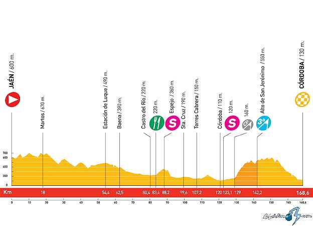
Stage 1: Lisboa (PT) - Lisboa (PT), 118km
GPM:
Alto de Montes Claros (cat.3) 1,6km @ 7,3%
Yes, a slightly unusual start for the race, as we go with an overseas start and for the second time in three routes, we’re setting off from Portugal, this time from the capital rather than from the Algarve as we did before. The city played host to the Vuelta’s first ever overseas Gran Partida, back in 1997, but the race would wait until 2009’s Dutch start to repeat the process. Overseas starts have become more common since ASO’s influence has expanded, as 2017 saw a French start, and three of the last four Vueltas - as well as the 2026 one’s intended start - have been overseas as well. But back in the 2000s, this was rare. The Portuguese start in 1997 saw the race commence with a road stage, as we do here, but unlike that stage this will be a circuit race inspired by something more in keeping with the 2000s timeframe - the 2001 UCI Road World Championships. Held on a course which looped around the Parque Monsanto, these championships were very common to the style of the era, with a couple of smaller climbs mid-circuit and then a wide and fast finish. The overall schedule of races shows an interesting mix of winners; men’s junior road race winner Oleksandr Kvachuk would spend a few years on ProContis but retire with a national title and a stage win in the Tour of Romania his biggest achievements, but women’s junior road race winner Nicole Cooke would win the overall World Cup two years later and the Giro three years later, go on to win World and Olympic titles, and then be written out of history by British Cycling for her tendency to go off script and being perceived as less marketable than Lizzie Deignan. Bitter much? You bet I am. Yaroslav Popovych won the under-23 road race, and of course this is Popovych Mk1, the version that would podium the Giro and in all honesty was already tailing off in his Discovery Channel days; after a few years of being the shell of a domestique collecting a paycheque in the 2010s after first his running buddy Volodymyr Bileka being busted for EPO and then his computer being seized by anti-doping enforcers, we often forget just how good early Popo had been. But the main event from a Spanish perspective, of course, was the men’s Road Race.
Óscar Freire had been a shock for most when he had won the 1999 World Championships, thanks to a late sneak move, and many were worried that the rainbow jersey would be somewhat anonymous. By 2001 that was no longer a fear, with his having moved to Mapei and won two Vuelta stages, several other smaller races, and finished on the podiums of Milan-San Remo, Paris-Tours and the 2000 World Championships in the intervening period. However, one thing that remained one of Óscar’s most endearing but frustrating characteristics was his somewhat air-headed absent-mindedness, and the Lisbon World Championships were famous for this. Firstly, he managed to get lost on a training ride, having taken a wrong turn and forgotten to note the name of his hotel, resulting in him having to take a taxi ride with his bike in his cycling gear driving around landmarks of Lisbon until he spotted a building that looked like the team hotel. Secondly, perhaps a product of the relatively short (11,8km) circuit meaning over 20 laps were required to make World Championship distance, he rolled over to a teammate during the dénouement of the race to ask how many laps were left, only to be met with a puzzled response to the effect of, “what are you on about, we’re entering the final kilometre!”. Óscar, in his inimitable fashion, then went on to win the sprint, of course - one of his most notable characteristics as a rider was his in-race recovery and durability; he would get over more obstacles than most sprinters, and would tend to perform ever better as distance increased, making him formidable in sprints after selective races and in Monument, Classic and championship events where distances were at their highest.
Here, however, this is far from a World Championship level distance. It may be a World Championships course, but we’re only doing ten laps of the circuit for a paltry 118km. This is, after all, day one of a very long race, and one area where I haven’t really played by the 2000s rules is that in the early 2000s the Vuelta did shorten its overall distances - the first half of the decade saw races mostly in the 2900-3100km range, which tended longer as the decade wore on. This stage is short both in reference to the kinds of shorter stages that you would see in those days, and also to help bring the overall distance down to a more acceptable level as I have a few longer stages here.
Views from and around Parque Monsanto, around which the 2001 World Championships course looped
So after all that context, we ought to discuss a little more about the circuit itself.
Here is the approximation from Italian blog Lasterketa Burua’s brilliant
index of World Championships courses - as you can see there are two climbs on the course, one short and very straightforward, the other slightly longer and including at least some gradients that could create a platform for attack. That said, even after 21 laps of the circuit, the race was settled by a sprint of 45 riders, so after just under half that distance we can probably expect a decent sized field to still be together; I might have questioned it ten years or so ago but seeing as we are now seeing speeds accelerate back up to those of the EPO era, I think we are likely to see a sprint of the more durable figures on this one - the chance to pull on the first red jersey and the chance to gain a bit of time may tempt some movement on the Montes Claros climb (we only give out points for one ascent, but the climb is the same - and probably worthy of cat.3 status at least at this point in the race - on all laps) on the last couple of laps, however otherwise I’d expect this to be a sprint finish - however as per my usual rule of thumb, I dislike when we see sprinters take a GT race lead and then not even attempt to defend it. They probably don’t stand a chance of defending it on stage 2… but at least they’ll have had to earn it in the first place.

Lisbon