
Race Design Thread
Page 7 - Get up to date with the latest news, scores & standings from the Cycling News Community.
You are using an out of date browser. It may not display this or other websites correctly.
You should upgrade or use an alternative browser.
You should upgrade or use an alternative browser.


- Apr 7, 2011
- 4,886
- 457
- 16,580
Echoes said:Can't it be possible for these cobbles to be added to the Hamburg Cyclassic (whatever you call it)?
Sure it would be possible. But don't even hope of it, it will never happen.

Tour of Slovakia - 1
Since I'm from Slovakia, I've made this route, that have not so much to do with the original race itself
It contains one short ITT and mostly hilly stages.
Tour of Slovakia
Stage 1: Nitra - Nitra (ITT), 16,7km
We start with rolling ITT, the only ride against the clock on this route. Start and finish lines are in the old town centre. This stage will set the first wearers of all jersey. Yellow for the GC, green for the points classification and red for the KOM classification.
Climbs:
Zobor - city part(cat.3) - 1,5km; 7%


The finish next to the Nitra castle on the right:

Since I'm from Slovakia, I've made this route, that have not so much to do with the original race itself
It contains one short ITT and mostly hilly stages.
Tour of Slovakia
Stage 1: Nitra - Nitra (ITT), 16,7km
We start with rolling ITT, the only ride against the clock on this route. Start and finish lines are in the old town centre. This stage will set the first wearers of all jersey. Yellow for the GC, green for the points classification and red for the KOM classification.
Climbs:
Zobor - city part(cat.3) - 1,5km; 7%
The finish next to the Nitra castle on the right:
- Apr 7, 2011
- 4,886
- 457
- 16,580
togo95 said:Since I'm from Slovakia, I've made this route, that have not so much to do with the original race itself
It contains one short ITT and mostly hilly stages.
Tour of Slovakia
Stage 1: Nitra - Nitra (ITT), 16,7km
We start with rolling ITT, the only ride against the clock on this route. Start and finish lines are in the old town centre. This stage will set the first wearers of all jersey. Yellow for the GC, green for the points classification and red for the KOM classification.
Climbs:
Zobor - city part(cat.3) - 1,5km; 7%
The finish next to the Nitra castle on the right:
May ia ask which programm you are using?
Tour of Slovakia - 2
Stage 2: Nitra - Detva, 185km
For the next two stages riders will go generally east direction.
This second stage opens up many possibilities. It can be won from a long breakaway, late attack, but most likely it will be a sprint from a selected group.
Climbs:
Mackov vŕšok(cat.2 at km 92) - 8,5km; 3,7%
Kamenný vrch(cat.3 at km 123) - 5,3km; 4%
Vidov Vrch(cat.3 at km 140) - 9km; 3%
Podlysec(cat.3 at km 155) - 3km; 4,5%
Vybohova poľana(cat.3 at km 166) - 4km; 5%


The finishing town is small and it's in the heart of Slovakia:

Stage 2: Nitra - Detva, 185km
For the next two stages riders will go generally east direction.
This second stage opens up many possibilities. It can be won from a long breakaway, late attack, but most likely it will be a sprint from a selected group.
Climbs:
Mackov vŕšok(cat.2 at km 92) - 8,5km; 3,7%
Kamenný vrch(cat.3 at km 123) - 5,3km; 4%
Vidov Vrch(cat.3 at km 140) - 9km; 3%
Podlysec(cat.3 at km 155) - 3km; 4,5%
Vybohova poľana(cat.3 at km 166) - 4km; 5%
The finishing town is small and it's in the heart of Slovakia:
- Feb 20, 2010
- 33,132
- 15,541
- 28,180
There is a lot of potential for some seriously nasty mountain stages in Slovakia. Look forward to seeing what else we have in store.
One problem with MMR is that it does tend to include false flat in its mountains (and if the mountain flattens out at all you need to do your own calculations. Sometimes you have to profile the climb in isolation as well as on the full route in order to get a proper accurate figure for it.
One problem with MMR is that it does tend to include false flat in its mountains (and if the mountain flattens out at all you need to do your own calculations. Sometimes you have to profile the climb in isolation as well as on the full route in order to get a proper accurate figure for it.
MapMyRide
Yeah, it's really annoying sometimes. Another thing is when you have a climb that goes immediately down after reaching the top, then the top of the climb in the profile and the datailed climb data is like 100m lower than in reality. If this also happens at the base of the climb, then the data for the ascent can be quite inaccurate.
Libertine Seguros said:There is a lot of potential for some seriously nasty mountain stages in Slovakia. Look forward to seeing what else we have in store.
One problem with MMR is that it does tend to include false flat in its mountains (and if the mountain flattens out at all you need to do your own calculations. Sometimes you have to profile the climb in isolation as well as on the full route in order to get a proper accurate figure for it.
Yeah, it's really annoying sometimes. Another thing is when you have a climb that goes immediately down after reaching the top, then the top of the climb in the profile and the datailed climb data is like 100m lower than in reality. If this also happens at the base of the climb, then the data for the ascent can be quite inaccurate.
- Apr 7, 2011
- 4,886
- 457
- 16,580
Stage 20
Before this stage there's a transfer of ca 250km, but i think in general there weren't toom many transfers so it should be ok.
TT Dortmund---Duisburg 64km
An long and all flat TT through the Ruhrgebiet,the former industrial center of Germany, offers the last chance to change something in the overall standings. Time Gaps shuld certainly be big.
So who will come out on top? A traditional GC rider? Or has a rolleur type like Tony Martin managed to limit his loses in the mountains and can bring home the very first GC in Germany? All types of riders had their chance with this route and it will be intersting to see who takes it home today.
- Apr 7, 2011
- 4,886
- 457
- 16,580
Stage 21
Bielefeld--- Köln 100km
The tour finishes with a short Tour d'Honeur stage to the City of Cologne.
The sprinters will battle out this one. Those who won the jerseys will celebrate.
A long and tough GT has come to an end. After 3 weeks of racing, winners and losers enjoy the well deserved celebration by the fans!
- Feb 20, 2010
- 33,132
- 15,541
- 28,180
200+ km of TT, and only one high mountain stage with more than one climb... Tony is going to love you
Bavarianrider said:Sure it would be possible. But don't even hope of it, it will never happen.
I understand that for financial reasons, they prefer making loops around Hamburg.
Bispingen is 73.6km far from Waseberg. Waseberg is currently 16km from the finish line. The cobbles would be a bit too far but if there are other sections in the area, more particularly between Bispingen and Hamburg, it can be great.

- Apr 7, 2011
- 4,886
- 457
- 16,580
Summary
Total lengh: 3467km
-7 pure flat stages, 3 ITT, 1TT, 2 High Mountain Stages, 4 Medium Mountain Stages, 1 Cobled Stage, 3 Hilly Stages
-5 Mountain finishes: 2 HC, 1 Cat 1, 2 Cat 2
- 2 Uphill finishes in Mammolshain and Winterberg
- 12km flat prologue, 58km TTT, 59km TT including a cat 2 and a cat 1 mountain, 63km flat TT
Comment:
I tried to include all parts of Germany, which i di pretty well i think. I also tried to give this GT a destinctive German charakter. I used the Terrain Germany has, not artifically trying to copy the other 3 Gts. We want to set us apart in order to atract riders. My goal was to create a balanced route which i think i did, There are stages in many different terrains. Almost everytype of rider has a few stages where he can shine.In terms of the GC i wanted to give many different types of riders a chance.
So want do you guys think of my parcours. Which type of riders will it attract. Who will ahve a shot at winning many stages? Which favors would you favor for the GC? Who will battle for the jersey. Especially who will win the points jersey? A sprinter, an allrounder, a puncheur, a climber?
I hope you enjoyed this trip through Germany!
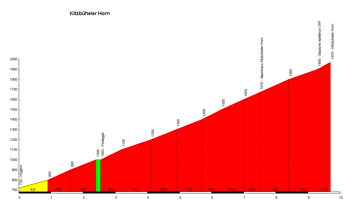
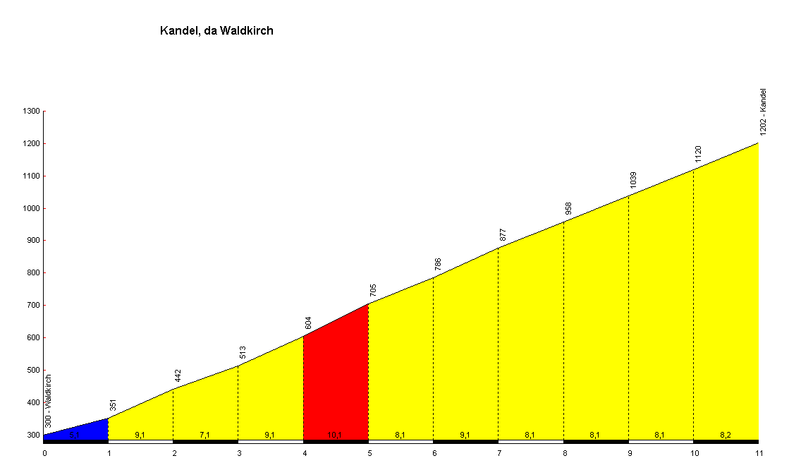
Here are the mountain finishes once again.

5.6km


Total lengh: 3467km
-7 pure flat stages, 3 ITT, 1TT, 2 High Mountain Stages, 4 Medium Mountain Stages, 1 Cobled Stage, 3 Hilly Stages
-5 Mountain finishes: 2 HC, 1 Cat 1, 2 Cat 2
- 2 Uphill finishes in Mammolshain and Winterberg
- 12km flat prologue, 58km TTT, 59km TT including a cat 2 and a cat 1 mountain, 63km flat TT
Comment:
I tried to include all parts of Germany, which i di pretty well i think. I also tried to give this GT a destinctive German charakter. I used the Terrain Germany has, not artifically trying to copy the other 3 Gts. We want to set us apart in order to atract riders. My goal was to create a balanced route which i think i did, There are stages in many different terrains. Almost everytype of rider has a few stages where he can shine.In terms of the GC i wanted to give many different types of riders a chance.
So want do you guys think of my parcours. Which type of riders will it attract. Who will ahve a shot at winning many stages? Which favors would you favor for the GC? Who will battle for the jersey. Especially who will win the points jersey? A sprinter, an allrounder, a puncheur, a climber?
I hope you enjoyed this trip through Germany!
Here are the mountain finishes once again.
5.6km
- Apr 7, 2011
- 4,886
- 457
- 16,580
- Feb 20, 2010
- 33,132
- 15,541
- 28,180
The mountain finishes were certainly very steep, but I think that it would still attract the rouleurs and strongmen more. Certainly with the cobbles in week 3. While you had some brutal MTFs, I can't help but feel that apart from the Kandel stage (which was the best-designed stage of the race hands down) there isn't really a multi-climb stage that will allow the climbers to wear down the strong rouleurs, and as a result I'd expect most of the climbers to be pretty much out of contention before we get to the Kitzbüheler Horn, because steep and evil though it is, if everybody's fresh when they get there they may struggle to pull back the kind of deficits they're inevitably going to pick up with 200km against the clock. It perhaps needed another difficult stage in the Schwarzwald - one with multiple climbs such as Zuflucht, Schliffkopf and Mummelsee could have rounded the course off a bit more.
Certainly can't fail you for your inclusivity - apart from the Saarland and maybe Bremen I think pretty much every Land got some action?
Certainly can't fail you for your inclusivity - apart from the Saarland and maybe Bremen I think pretty much every Land got some action?
- Aug 31, 2011
- 324
- 0
- 0
Echoes said:Anyone to draw a good classic single-day race in the Czech Republic between Prague and Olomouc, with this climb in it:
OT but Olomouc is an awesome place.
RownhamHill said:OK, I'm not sure how to do the fancy profiles or maps, or embed pictures (if anyone can advise I'll try and edit), but I saw something saying GB might bid for the World Championships the other day, and it got me thinking about a fantasy world champs course in my hometown Bristol.
I reckon you could start next to the harbourside on Anchor Road, go up St Michael's Hill - which is about a kilometer that must be around 10% average gradient, with (considerably) steeper sections, through Clifton and across the Suspension bridge, then loop around the top of Ashton Court park (This is all fairly flat ) before the descent round the South of the Park (which is probably about three/four kilometers at an average of about -8% and not particularly technical).
Then back up Rownham Hill to the bridge - there's a link to a Strava profile below which says its 9% average with 16-17% section. Once you cross back into Bristol proper, turn left and descend down onto the Portway, which takes you underneath the Suspension bridge and back onto Anchor Road for the start finish - I reckon it's about 20 kilometers a lap, so eight laps, 16 kilometers of proper climbing, about 25 kilometers of fast descending, and the rest flat, all with a beautiful/historic back drop.
There might be a problem with using the bridge in two directions (and more to the point the approach roads, as the bridge itself is naturally split into two carriageways) especially if the field splits, but assuming you could overcome that I reckon it would be fantastic - no idea who would win either!
Some context:
Here's a map I made http://friendfit.com/routeview.php?rtnum=75596&from=fitblog
A photo of St Michaels Hill http://www.yourlocalweb.co.uk/images/pictures/16/38/st-michaels-hospital-161360.jpg)
A profile of the second climb http://www.strava.com/segments/rownham-hill-short-bristol-670831
Some images of the Suspension Bridge: http://www.google.co.uk/search?tbm=...1634l2774l0l4191l11l8l0l0l0l0l162l969l2.6l8l0
I think this sounds like a great course. Hard and challenging, just as a world's should be.
Tour of Slovakia - 3
Stage 3: Hriňová - Košice, 190km
Third stage is hilly stage with one biger climb in it and flat finish towards the second biggest city in Slovakia - Košice. It's not an easy one, the first cat.1 climb is here, but the GC won't be decided here.
Climbs:
Detvianska huta(cat.2 at km 7) - 6,7km; 5,8%
Sedlo Chorepa(cat.3 at km 35) - 4km; 5%
Sedlo Brezina(cat.3 at km 49) - 4km; 5,8%
Hrádok(cat.2 at km 89) - 6,5km; 5,5%
Úhornianske sedlo(cat.1 at km 126) - 9,5km; 6,8%


Departure is in Hriňová:

Stage 3: Hriňová - Košice, 190km
Third stage is hilly stage with one biger climb in it and flat finish towards the second biggest city in Slovakia - Košice. It's not an easy one, the first cat.1 climb is here, but the GC won't be decided here.
Climbs:
Detvianska huta(cat.2 at km 7) - 6,7km; 5,8%
Sedlo Chorepa(cat.3 at km 35) - 4km; 5%
Sedlo Brezina(cat.3 at km 49) - 4km; 5,8%
Hrádok(cat.2 at km 89) - 6,5km; 5,5%
Úhornianske sedlo(cat.1 at km 126) - 9,5km; 6,8%
Departure is in Hriňová:

Tour of Slovakia - 4
Stage 4: Košická Belá - Levoča, 195km
From now on the route is going back to the west, but now through the northern part of Slovakia.
Stage 4 is another hilly one, but now there are more and harder climbs. Moreover they are closer to the finish. In fact the finish line is at the top of short hill in Levoča, one of the most beautiful towns in Slovakia. This stage also includes some unpaved roads. Total altitude gain for this stage is almost 4000m.
Unpaved sections:
at km 99 - 105
at km 109 - 121 (including two steepest climbs on the route)

at km 173 - 179
Climbs:
Gregorov prameň - 4km; 5%
Skala(cat.2 at km 54) - 7km; 5,3%
Brutovce - 3,8km; 6%
Javor(cat.1 at km 88) - 9,5km; 5,5%
Javorinka - 4km; 5,7%
Nad peklom(cat.1 at km 113) - 3,6km; 9,5%
Javorina(cat.2 at km 119) - 3km; 9,5%
Levoča - 1km; 7%
Krúžok(cat.2 at km 157) - 5,5km; 6,8%
Javorinka(cat.2 at km 171) - 6,5km; 5%
Kúty(cat.3 at km 186) - 3,6km; 6,5%
Levoča - 1,4km; 7,2%


Levoča:

Stage 4: Košická Belá - Levoča, 195km
From now on the route is going back to the west, but now through the northern part of Slovakia.
Stage 4 is another hilly one, but now there are more and harder climbs. Moreover they are closer to the finish. In fact the finish line is at the top of short hill in Levoča, one of the most beautiful towns in Slovakia. This stage also includes some unpaved roads. Total altitude gain for this stage is almost 4000m.
Unpaved sections:
at km 99 - 105
at km 109 - 121 (including two steepest climbs on the route)
at km 173 - 179
Climbs:
Gregorov prameň - 4km; 5%
Skala(cat.2 at km 54) - 7km; 5,3%
Brutovce - 3,8km; 6%
Javor(cat.1 at km 88) - 9,5km; 5,5%
Javorinka - 4km; 5,7%
Nad peklom(cat.1 at km 113) - 3,6km; 9,5%
Javorina(cat.2 at km 119) - 3km; 9,5%
Levoča - 1km; 7%
Krúžok(cat.2 at km 157) - 5,5km; 6,8%
Javorinka(cat.2 at km 171) - 6,5km; 5%
Kúty(cat.3 at km 186) - 3,6km; 6,5%
Levoča - 1,4km; 7,2%
Levoča:
- Feb 20, 2010
- 33,132
- 15,541
- 28,180
- Feb 20, 2010
- 33,132
- 15,541
- 28,180
If there's one thing I am, it's predictable. So we have another short stage race in the north of Spain!
Since the sad loss of the Circuito Montáñes this year, one of the biggest amateur events, there is no Cantabrian stage race of any great consequence. This problem shall be rectified, as I present the Vuelta a Cantabria.
Stage 1: Torrelavega - Mataporquera-Valdeolea (190km)

We start with a stage from Torrelavega up to the plains on the border with Castilla y León. Though there is a fair amount of climbing to be done - the stage begins at 20m above sea level and finishes 900m higher up, after five categorised climbs - this is one that should be duked out by the fast men that are able to hold on on the Puerto de la Palombera, as there is some 2km between the final corner and the finish line painted in the industrial village of Valdeolea.

Climbs:
Alto de la Ayuela (cat.3) 6,2km, 3,5%
Puerto de la Palombera (cat.1) 22,0km, 4,3%
Alto de Hoyos (cat.3) 4,0km @ 5,0%
Alto de Hoyos (cat.3) 4,0km @ 5,0%
Alto de Hoyos (cat.3) 4,0km @ 5,0%
Torrelavega:

Mataporquera-Valdeolea:

Since the sad loss of the Circuito Montáñes this year, one of the biggest amateur events, there is no Cantabrian stage race of any great consequence. This problem shall be rectified, as I present the Vuelta a Cantabria.
Stage 1: Torrelavega - Mataporquera-Valdeolea (190km)
We start with a stage from Torrelavega up to the plains on the border with Castilla y León. Though there is a fair amount of climbing to be done - the stage begins at 20m above sea level and finishes 900m higher up, after five categorised climbs - this is one that should be duked out by the fast men that are able to hold on on the Puerto de la Palombera, as there is some 2km between the final corner and the finish line painted in the industrial village of Valdeolea.
Climbs:
Alto de la Ayuela (cat.3) 6,2km, 3,5%
Puerto de la Palombera (cat.1) 22,0km, 4,3%
Alto de Hoyos (cat.3) 4,0km @ 5,0%
Alto de Hoyos (cat.3) 4,0km @ 5,0%
Alto de Hoyos (cat.3) 4,0km @ 5,0%
Torrelavega:
Mataporquera-Valdeolea:
Tour of Slovakia - 5
Stage 5: Spišská Nová Ves - Kráľová hoľa (1946), 190km
This time we go through Slovak Paradise (Slovenský Raj) and finish is in mountain range Low Tatras (Nízke Tatry), the second highest in Slovakia. Whole stage is filled with climbs which aren't so challenging, at least compared to what lies at the end of this stage.
This only real mountain stage in this tour is finishing on the highest paved road in Slovakia. On the top of the climb Kráľová hoľa (King's Bald Mountain), next to the TV transmitter, without any doubt the hardest climb in Slovakia.
This mountain is also one of the most legendary mountains in Slovakia, and one of informal Slovak national symbols.
Climbs:
Sedlo Grajnár(cat.2 at km 17) - 10km; 4,3%
Dobšinský kopec(cat.2 at km 73) - 7,3km; 5,5%
Sedlo Súľová(cat.3 at km 91) - 4km; 5,8%
Sedlo Hrádok(cat.3 at km 134) - 4km; 6,4%
Muránska Huta(cat.2 at km 168) - 5km; 7%
Sedlo Javorinka (cat.2 at km 172) - 2,6km; 8,5%
Kráľová hoľa(special category at km 190) - 13,5km; 8,5%


Šumiac, base of the climb to Kráľová hoľa:

Stage 5: Spišská Nová Ves - Kráľová hoľa (1946), 190km
This time we go through Slovak Paradise (Slovenský Raj) and finish is in mountain range Low Tatras (Nízke Tatry), the second highest in Slovakia. Whole stage is filled with climbs which aren't so challenging, at least compared to what lies at the end of this stage.
This only real mountain stage in this tour is finishing on the highest paved road in Slovakia. On the top of the climb Kráľová hoľa (King's Bald Mountain), next to the TV transmitter, without any doubt the hardest climb in Slovakia.
This mountain is also one of the most legendary mountains in Slovakia, and one of informal Slovak national symbols.
Climbs:
Sedlo Grajnár(cat.2 at km 17) - 10km; 4,3%
Dobšinský kopec(cat.2 at km 73) - 7,3km; 5,5%
Sedlo Súľová(cat.3 at km 91) - 4km; 5,8%
Sedlo Hrádok(cat.3 at km 134) - 4km; 6,4%
Muránska Huta(cat.2 at km 168) - 5km; 7%
Sedlo Javorinka (cat.2 at km 172) - 2,6km; 8,5%
Kráľová hoľa(special category at km 190) - 13,5km; 8,5%
Šumiac, base of the climb to Kráľová hoľa:
TRENDING THREADS
-

-
Dwars door Vlaanderen 2026, April 1
- Started by Dazed and Confused
- Replies: 371
-
 Ronde van Vlaanderen 2026, monument, April 5 (men's)
- Started by Krzysztof_O
- Replies: 293
-
-
 Milan San Remo, March 21, 2026, 298 km monument
- Started by topcat
- Replies: 1K
-
-
 Teams & Riders The Remco Evenepoel is the next Eddy Merckx thread
- Started by DNP-Old
- Replies: 39K

Cyclingnews is part of Future plc, an international media group and leading digital publisher. Visit our corporate site.
© Future Publishing Limited Quay House, The Ambury, Bath BA1 1UA. All rights reserved. England and Wales company registration number 2008885.