Valv.Piti said:
Sierra Nevada seriously confuses me.
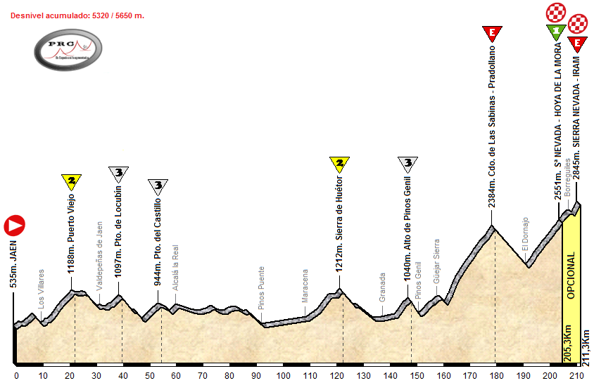
Essentially, there are two long roads from Granada to the Pradollano resort.
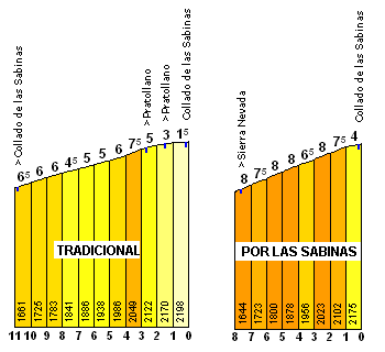
The first is the main road, the A-395, which goes through Canales, El Dornajo and up the 'classic' route into Pradollano (around 2100m), then you leave it to head up on the town roads through Pradollano to the Cruce (just under 2400m altitude) at the top where you rejoin the main road.
The second goes from Pinos Genil to Güéjar Sierra, up the Hazallanas climb on the GR-3200 to El Dornajo, then on the A-4025 through Las Sabinas to join the A-395 at the top of Pradollano then continuing to the Cruce at just under 2400m, where the town roads converge with the main road and then there's just one road to Pico Veleta, which goes via Hoya de la Mora (and has a side-road that goes to the Borreguiles ski station and IRAM).
There are a couple of roads which join the A-395 on its way from Granada to El Dornajo.
- the A-4206 from Pinos Genil (approx. 1000m altitude), which doesn't fundamentally change the climb but enables it to be linked to Blancares better
- the GR-3202 from Monachil (approx. 1450m altitude), otherwise known as El Purche or the Collado Muerto.
The A-395 (classic Sierra Nevada ascent) and A-4025 (ascent via Collado de Las Sabinas) come close to one another a couple of times, and there are a couple of link roads, which open up race design possibilities.
- the point called El Dornajo (approx. 1680m altitude) where the GR-3200 becomes the A-4025, via a very short linking road. This is also called the Alto de Hazallanas in cycling parlance because it's the end of the Haza Llana road.
- The A-395 itself, at the entrance to Pradollano at 2100m, links to the Collado de las Sabinas at just under 2200m.
This means you can have a mountain pass on the road at several points:
- at the convergence of the A-4026 and A-395
- at the convergence of the GR-3202 and A-395 (just after El Purche/Monachil/Muerto)
- at the commencement of the A-4025 (El Dornajo/Alto de Hazallanas)
- at the convergence of the A-4025 and A-395 (Collado de Las Sabinas)
- at the convergence of the A-395 and the Pradollano urban roads (Pradollano-El Cruce)
I made a handy "metro"-style map of how the roads interact with one another using Paint.
Edit: replaced with a better one

")