• The Cycling News forum is looking to add some volunteer moderators with Red Rick's recent retirement. If you're interested in helping keep our discussions on track, send a direct message to @SHaines here on the forum, or use the Contact Us form to message the Community Team.

    In the meanwhile, please use the Report option if you see a post that doesn't fit within the forum rules.

    Thanks!

21 ESP climbs the Vuelta should use

So, once more Javier Guillén and his band of merry men released the race route for the year's Vuelta, and once more we have a lot of one-climb stages, short and über-steep, and not so much in the way of multi-climb epics or long, winding suffer-fests.

So, inspired by Linkinito's awesome TdF thread about 21 HC climbs the Tour should use, I hereby launch a direct, and in all honesty, somewhat inferior rip-off. Here, "ESP" is not short for "España" but "Especial", as in the Vuelta's equivalent of Hors Catégorie.

Now, given the Vuelta's propensity to award category 1 for some fairly non-cat.1 climbs (I like Cordal south, but 5,6km @ 8,9% is not equal to Port de Balès, and while short climbs like Peña Cabarga and Urkiola may arguably merit cat.1 due to steepness, there are still a number of climbs the Vuelta gives cat.1 to that would not merit it in the Giro or Tour), maybe not all of the 21 climbs I will nominate in this thread are genuinely "beyond categorisation", but we will see 21 big climbs that could genuinely make a difference in the racing but that the Vuelta is ignoring, whether it be for some time or that it simply hasn't discovered them yet. Guillén's guys have discovered a great many climbs over the last few years - Bola del Mundo, Haza Llana, Peñas Blancas, La Farrapona, Cotobello and Ancares are all new discoveries, while others such as Peña Cabarga are rediscoveries of long forgotten summits - but there is still so much potential left unused in Spain that the Vuelta could be using.

And so we proceed:

1. Haza del Lino (Andalucía)
The Monte Grappa on the Mediterranean

5201027535_2033714680_o_zps37bb6d9f.jpg


4077481547_fe4d8965f2_o_zpsf94e001e.jpg


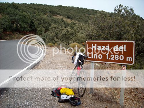
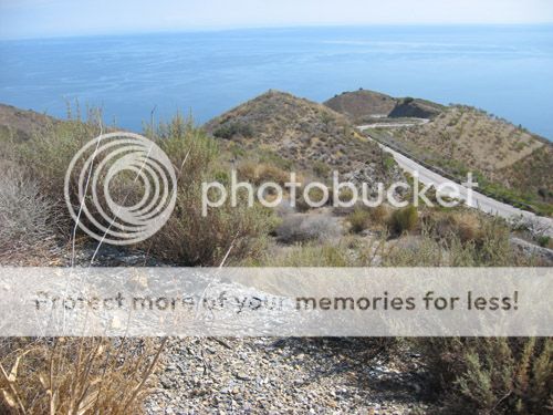
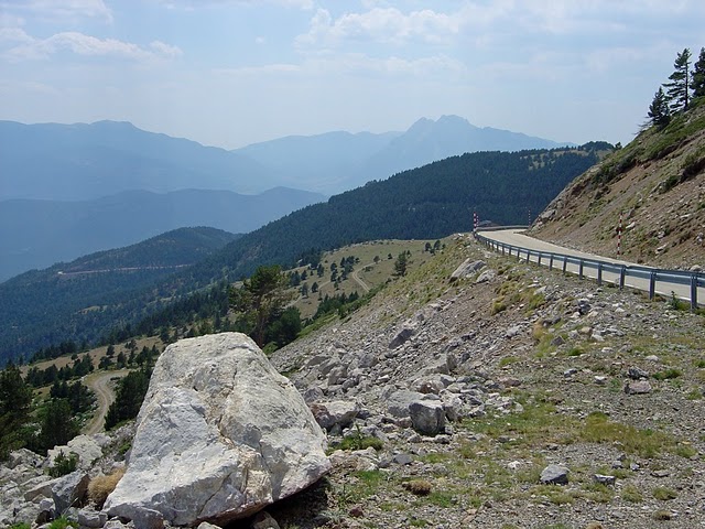
Long a favourite of mine on this forum, Haza del Lino rises almost straight out of the sea right in the south of the country, beneath the Sierra Nevada range. There are a number of ways of ascending its 1280m.

Haza del Lino was almost ascended in the 2006 Vuelta, but instead the chosen climb, early in the stage to Granada via El Purche, was La Contraviesa, parallel to the east to Haza del Lino, although they could have come via the longer but less difficult Albuñol side of the climb, which is nearly 30km long, but averages under 5%. There are two fully HC sides still ripe for discovery plus a further side that would be at least a strong category 1.

HazaLino1.gif


Haza del Lino from Castell de Ferro via Rubite is 22,2km @ 5,8%. This is perhaps the "classic" way to climb to the summit, featuring that brutally difficult middle section - there are 7km averaging 9,5% from kilometre 6 to 13. After a brief descent, there is then another 7km of more typical matters, but the climb really strikes out hard in the middle. The last couple of kilometres ease off slightly, but there's plenty of damage already done.

haza-del-lino-polopos.jpg


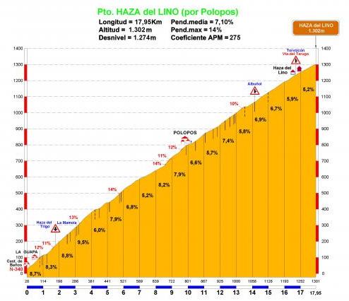
Haza del Lino from Castillo de Baños via Polopos is 18,0km @ 7,1%. It is a much more consistent climb than the Rubite side, but the average is steeper and there is consequently no let-up. In terms of climb characteristics, it is similar to Chamrousse or Le Grand Colombier, only where they exceed our Andalucían giant in altitude, Haza del Lino fights back with the possibility of 40º weather in the south of Spain. The tarmac is also less good on the Polopos side than the Rubite side, which adds to the challenge.

The best thing about Haza del Lino is that it is a pass with many sides, so there are many options for connecting it to other difficult climbs. For example, one could descend from either of the two mentioned sides via Torvizcón to Los Tablones and then climb to the Puerto del Camacho (ignore the second half of the profile - Sierra de Lujár is in far too poor a state for a race to visit at present) for a perfectly reasonable MTF (12km @ 6,8%); or one could descend from either side of Haza del Lino via Puerto del Camacho and climb into Torvizcón as per the first part of that profile. My third side of Haza del Lino, which I call the solid cat.1 version as opposed to Rubite and Polopos, is the Órgiva version which comes through the Puerto del Camacho and is around 20km in length, but just 5%, as after Camacho there's a short descent and then some more shallow climbing. Ideally, Haza del Lino would be climbed from the south and then this side could be descended.

Very solid potential finishes even descending this way would include climbing into Órgiva itself, a short puncheur type climb of 2-3km in length, or extending beyond that, my personal preference, into the village of Cáñar, which is 11km at 6,5% but as it is not a super-hard climb, it would be like Bormio 2000 following on from the Gavia; Haza del Lino would then top 31km from the finish, making attacking there not the impossibility it once seemed. Heck, throw in the Alto del Conjuro, which descends right into the base of the Rubite side of Haza del Lino, and you have a fairly passable impersonation of Tonale-Gavia-Bormio 2000 from the 2004 Giro, just with more heatwaves and less snow.

Another option would be to descend Haza del Lino via the easier side to Albuñol noted above, and either finish there or then take on the climb to Venta del Tarugo, either stopping in Albondón (a perfectly valid stage finishing 10km @ 6,5%, cat.1) or going to the summit (17,5km at around 6%, cat.1 and borderline ESP itself, though not as difficult as Haza del Lino). It would also be possible to climb to Venta del Tarugo, and after a period of flat at altitude, arrive by Haza del Lino to descend the Polopos side, and climb the Rubite side but not all the way, then descending through Puerto del Camacho to Órgiva.

Unlike many HC climbs in the Vuelta's recent history, and many possibilities and candidates you may see on this list, Haza del Lino is an extremely versatile climb that can be used in dozens of different ways depending on the goal of the organiser. It can be a feature climb, it can be a lead-in climb, it can be a leg-warming early climb in a tough stage that, after some flat and/or smaller climbs, then goes on to La Ragua, or even to Monachil and the Sierra Nevada climbs. And that's why it's absolutely ludicrous that it isn't as much a part of the Vuelta's lore as ideally located climbs like Croix-de-Fer, Gavia or Peyresourde are to their respective home races.
 
Sep 29, 2012
325
1
0
Visit site
Libertine Seguros said:
So, inspired by Linkinito's awesome TdF thread about 21 HC climbs the Tour should use, I hereby launch a direct, and in all honesty, somewhat inferior rip-off.
Well, I'm very glad to see that one of the most active members of this forum and well-known "traceurs" got the inspiration from one of my rare threads here (I'm not that kind of a cycling fanatic, just a guy that kinda sees the "technical aspects of cycling" as a personal curiosity). You talked about doing it six months ago, and I'm pleased to see that you're now starting the spanish journey of unknown climbs.

And I can say it's definitely not an inferior rip-off. It is full of information, with lots of details concerning its possible use in a Vuelta stage. My posts were more focusing on the geography and the history of the climbs (to put the mark on the TdF history considering its 100th edition), and sometimes they were quite short (mostly the first and the most hidden ones). The most important thing is that you give your style to this thread, and you did it wonderfully by the first post. Simply brilliant.

I'm really sure that you can bring 21 solid ESP climbs that should definitely have their place in the Vuelta. Spain is much more mountainous than France and therefore gives much more possibilities to find ESP-worthy climbs.

Btw, I have a single question: when did the ESP category appeared in the Vuelta? I heard it was a kinda recent addition, but I might be wrong.

Also, shame that the forum only allows for 4 images at once in a post, this kind of thread really needs some pics to see the climbs in their full beauty.

Que este viaje está lleno de descubrimientos. (Sorry for my poor spanish level, Google Translate ^^)
 
This is gonna be a great thread. While I'm quite familiar with French geography and did not discover that much in linkitos nonetheless brilliant thread, Spain is a bit of a black hole for me. Looking forward to seeing Libertine's discoveries. Maybe I'll follow up with "21 great Flemish country roads the Scheldeprijs should use". :p
 
2. Picón del Fraile (Cantabria)
The endless grind to the other Bola

15(121).jpg


Oh, you want scenery? You've got it.

P1020308.JPG


I have classed this one as being in Cantabria because the summit is. The majority of the climb is in Cantabria, but the last few kilometres, between the Portillo de Lunada and the very end of the climb, are in Burgos. This is one of the least traditionally steep climbs we will see, but it's also one of the longest.

PiconFraile.gif


Picón del Fraile, from the northwestern (Cantabrian) side is 27,6km @ 5,1%. However, if one is to link it directly to El Caracol, the descent will deposit you a short way into the climb, and to go from there directly to Picón del Fraile will be 19,3km @ 6,0%. Things are pretty scenic as we head from the low mountains of the Sierra Cantabria up to the their higher counterparts that form the boundary between the high plateau of Castilla y León and the mountainous terrain that takes us to the ocean.

There are barely any moments of respite from 5km into the climb to 23km into the climb; while few gradients ever get truly crushing (the maximum gradient we reach before the Portillo de Lunada is 12%), this is pretty constant, driving pain and will grind the bunch down for sure. After the Portillo there is a very brief break before the tarmac worsens slightly and we head up the final stretch, the access road to the military installation Picón del Fraile, which is 4,6km at an average of 7% but with a maximum of 17%. The last 2km average nearly 10% with the last 600m at 11,6%, but this isn't one of those climbs like Cuitu Negru where the final few kilometres are so steep compared to the rest of the climb that everything will be guaranteed to be left to them.

Options for climbing Picón del Fraile from this side are numerous. The most logical way would be direct off the back of Caracol, but you could also come off the back of the Puerto de Alisas, with a bit more flat before the base of Picón del Fraile. I would argue that the best route from here would be to approach from the west, and have Puerto del Escudo (1) before the back to back double of la Braguía (2) and Caracol (2) leading straight to Picón del Fraile (Esp), like this (I disagree with whoever labelled Escudo HC, even by Unipublic's standards!).

Coming from the east, however, it makes less sense to use this HC side of Picón del Fraile, and instead my choice in an anti-clockwise course would be to use the much easier southern side.

picon%20del%20fraile.gif


From the south, Picón del Fraile is 14,7km @ 5,4%, a comparative cake-walk; barely any steeper, and half as long as the Cantabrian side. The final 4,6km are the same, so the irregular slopes of the access road are maintained, but this easier side (which I would have to categorise as a cat.1, no way does this side justify the Esp) does have one major advantage over its northern counterpart - that it commences right off the descent from another absolutely brilliant Spanish climb that the Vuelta hasn't discovered - the brutal Picón Blanco. To tell the truth, I considered including Picón Blanco in this countdown, but with the amount of climbs available to me and bearing in mind it is just 8,5km in length, despite its horrifying slopes and its average of 9,1%, I simply couldn't justify it. There are a couple of climbs of relatively short length in the list, but they justify their inclusion slightly more than Picón Blanco. However, it does create a very difficult final 70km for a killer mountain stage, with Puerto de los Tornos (2 or 1 depending on Unipublic) then some flat before Picón Blanco with 27km remaining.
 
Sep 21, 2009
2,978
0
0
Visit site
The easier North side of Haza del Lino was climbed in the 1975 Vuelta during a stage fom Granada to Almería. The climb was far a way from the finish but the stage was won by the best climber and eventual GC winner Agustín Tamames.
 
icefire said:
The easier North side of Haza del Lino was climbed in the 1975 Vuelta during a stage fom Granada to Almería. The climb was far a way from the finish but the stage was won by the best climber and eventual GC winner Agustín Tamames.

I hadn't been aware of that, but still, 38 years classifies it as ripe for rediscovery, like Peña Cabarga or Rifugio Gardeccia that hadn't been seen since the 70s either *hopesforMontduChathopesforMontduChathopesforMontduChat* - and of course the main difficult sides remain unused, a bit like how they are *finally* using the eastern face of Cobertoria this year...
 
3. Puerto de la Cubilla (Asturias)
The Spanish Galibier

puertocubilla0gt.jpg


peseoxubia16wk1.jpg


When the 2010 Vuelta route was being developed, rumour-mongers had picked up that there was going to be a new mountaintop finish in Asturias, following climbs of San Lorenzo and Cobertoria. Now, personally I have no problem with Cotobello, it's a nice climb, but I can sympathise with the many fans who were just a tiny bit disappointed when the Cotobello rumour picked up steam. That's because one of the original rumours - which may just have been people putting 2 + 2 together to make 5 - was that the new Asturian summit would be the Puerto de la Cubilla, a sweeping and dramatic climb in the south of the province.

If you travel south from Pola de Lena, that town that has been the centre of many a key Asturian stage, then you travel parallel to the AP-66. At Campomanes, you reach a fork in the road. The Vuelta has traditionally turned left here, which means taking the road up to Brañillín, the Puerto de Pajares, and of course in 2012, to Cuitu Negru. If you turn right, however, it takes you up another winding, challenging mountain pass, only this one does not save its pain for the final 3km.

Cuitu Negru is, from Campomanes, 25km at 5,7%. However, without the additionals, going to Brañillín is 23,3km at 4,7%; what we're doing today is a much tougher climb than the latter, and a better climb for racing than the former.

Cubilla.gif


Counting the climb as all the way from Campomanes, the Puerto de la Cubilla is 28,1km @ 4,6%, however if we ignore the false flat and put our "comienza puerto" sign at Los Pontones, the climb becomes much more evident and the figures become 17,9km @ 6,1%, which help to characterise the difficulty a bit more.

2ce21pi.jpg


There is a reason this climb is known as the Spanish Galibier, and it's not just the stunning vistas. Here is a comparison of the two, with the final 21km of La Cubilla against the 23km of the southern face of the legendary French hors catégorie. This will also hopefully explain a bit more why Puerto de la Cubilla deserves that ESP categorization, as if 1180m vertical was not already enough... now, however, there is a weakness to La Cubilla, and that is that unlike Haza del Lino or Picón del Fraile, there is no "other" side of the climb - this is all there is. After the summit there's about a kilometre of gentle downhill to Casa Mieres, and then the tarmac runs out. If the tarmac could be completed, this would then link to Puerto de la Ventana, and the stage possibilities could get far more brutal, but as it is we do remain fairly limited in what we can do, just as with Cuitu Negru. The most difficult lead-in climbs will always be the Classic west face of Cobertoria and Cuchu Puercu via Cordal south, both of which would entail descending the brutal eastern side of Cobertoria before about 10km false flat before the start of the climb. Still, does the San Lorenzo-Cobertoria-Cubilla combo not remind you a little of Agnel-Izoard-Galibier in the 2011 Tour? No? Alright, alright, I know, San Lorenzo is hard but matches up to only the last part of Agnel which has a lot of gradual climbing beforehand, and Cobertoria West is much easier than Izoard. But the format is similar.

The other thing that La Cubilla gives you is that, with the max gradient of 12%, there are no super-impossible stretches that the contenders will guarantee waiting for, but off the back of a multi-climb stage it could be a killer. I would kill for coming from the north via Ventana to do San Lorenzo East, La Colledoria, Maravio, Cobertoria West, finishing on La Cubilla. That would destroy people.
 
Feb 20, 2011
396
0
0
Visit site
Amazing thread!

Looking forward to reading your description of Llano de Las Ovejas, Peña Trevinca, El Peñón, Las Gobernadas...(NW mountains)
 
4. Coll de Pradell (Cataluña)
Double the summits, double the punishment

pradell1.jpg


The Tour occasionally throws in the cobbles (although the best cobbled climbs of the area, with the sole exception of Mont Cassel, are in Belgium), and the Giro has made regular use lately of sterrato, whether it be in strade bianche stages like Montalcino 2010, or pure monstrous climbs like Kronplatz and the Colle delle Finestre. The Vuelta could try to ape this kind of action; it has the resources to do so. But the Vuelta has its own ace up its sleeve. Spain does not have its historic cobbled climbs (Ávila excepted), and the Giro has pre-empted it on the sterrato. But what Spain does have is hormigón.

It is only very recently that the possibility of utilising hormigón in the Vuelta has occurred to Unipublic, but with the introduction of Bola del Mundo in 2010, these rough, unforgiving concrete slopes have been an almost instant hit; Cuitu Negru has followed, and 2014 sees the introduction of San Miguel de Áralar, a Navarrese climb I have been bigging up for a long time. But that I can't really include here since they are using it. However, this climb sees our first patch of hormigón, albeit only for a couple of stretches as opposed to several kilometres at a time, and so it is the first we will see of it in this thread. And when I started considering climbs for this thread, this was the very first climb I wrote down. The Coll de Pradell is one of the true beasts of Spain, and somewhat unique in this thread in that it could be, from one of its toughest sides, a mere 2nd category, depending on Unipublic's moods. You will see when we get to it.

334qads.jpg


The "traditional" side of Coll de Pradell is 15,3km @ 6,7%. That in itself is a pretty severe climb, but it only tells half the story. The first 7,5km average 5,3%, and then there's even a kilometre or so of descent! After this, the climb passes through Vallcebre and then you have the final 6km @ 10,4%, of which the final three kilometres include a couple of stretches of hormigón, with a maximum gradient of a Purito-tastic 23%! Even before that, things have got pretty difficult, with some brutal hairpins to negotiate.

pradell15.JPG


When you bear in mind that those brutal, destructive final six kilometres actually flatten out - twice! - the difficulty of the other stretches is amplified even more so; there is nowhere to get into a rhythm, and so tempo grinding becomes a much more difficult proposition, with survival being much more realistic. There is, however, another way to the summit, that bypasses some of this, but comes with its own challenges. I speak of course of what, in an ideal world, would be the Vuelta's challenge to Peyragudes, the seriously punishing Fumanya-Pradell double.

fumanyapradell.PNG


The overall statistics of Coll de Pradell via Coll de Fumanya are 17,1km @ 6,3% which, noting the maximum slope once more of 23%, is pretty satisfactorily ESP-category. But here, there's more to consider, because this is truly two climbs in one. And neither of them are easy. Even on its own the Coll de Fumanya is a worthy climb that could break many a race apart - it clocks in at 11,5km @ 7,9% with several lengthy stretches of 12-15%, and several kilometres averaging 8-9%. It is definitely a pretty serious 1st category climb in its own right. But then you have the descent, which is not the cooling off or brief respite it may be in other climbs but a legitimate 2km full on descent at a similar gradient to the climb; this all leads up to joining the road from Vallcebre to the Coll de Pradell and taking on the hard ramps, for a final 3,5km @ 10,2% which could feasibly be given a category 2 rating - although the Vuelta's history suggests category 1 is possible given the ratings given to similarly short climbs like Xorret del Catí, which is slightly longer and a bit steeper (3,8km @ 11,5%) so either cat.1 or cat.2 is possible if Unipublic choose to split out the climbs (I would prefer them banded together as a single HC climb). Because there's so little respite between Fumanya and Pradell, it is highly unlikely that any gaps created on Fumanya can possibly be brought back on the descent, which will mean anybody who isn't feeling great could lose absolutely minutes. Plus there's the factor to be taken into account of getting out of the rhythm of climbing for a very short 2km burst; Fumanya is tough enough that riders will beg for a respite, but will need to be careful not to let the lactate build up as cramping up on the hell-slopes of the Coll de Pradell could be fatal.

A great strength for the Coll de Pradell in respect of racing, but a great weakness for the Coll de Pradell in respect of appearing in the Vuelta, is that there is absolutely nothing at the summit. Nada. Nichts. In the local tongue, res. Not even a widening out where they can park the TV trucks. Well, except this stunning view. So no stage finishes at the Coll de Pradell, which means they have to descend. Which means looking at the third side of the climb, the "reverse" side, via Saldes. Which is realistically not to be bothered with as a climb, but as a descent it could be key. It is essentially two-stepped, first descending into Saldes for about 10km at 6%, then a short uphill (about 3km at 4,5%, maybe a cat.3 on a flat stage but here "no puntable") and then a further 12km at around 5% downhill into Bagá. A very good race designing option could be to climb Pradell via Fumanya, then take the descent as far as where Vallcebre is noted on that profile, which would then cut out the first half of the climb via Vallcebre and leave the brutal part intact, if you're reading this and thinking "twice the same climb is the way to go" (in which case I'm honoured that you're reading, M. Prudhomme!).

The most likely way to approach Pradell in a race where the route wouldn't entail doubling back on oneself, criss-crossing the race route and other general Amstel Goldisms, would be from the south, in which case the most logical thing to do would be to precede it with the Collada de Sant Isidre, 5km at 8,6% and probably category 2. This descends directly to the foot of Fumanya-Pradell, so for my money this would be the most logical approach. Approaching Pradell from the north, however, you either come through the Tunnel del Cadí or you pass over the northwestern side of the neverending Coll de la Creueta, which averages 3,5% over 28,2km, but this is split into three distinct sections that could be individually categorised if Javier Guillén so wished. This would then give you about 30-35km of descent which gradually eases up on the way to Guardiola de Beguedà. However, this can be interrupted with the Collada Sobirana, the descent from which is directly into Guardiola de Beguedà, and connects almost as perfectly with the Vallcebre side of Pradell as Sant Isidre does with Fumanya-Pradell.

Since you cannot finish on the Coll de Pradell, but with its brutality it probably needs quite a focal point in the route, I see three possibilities for the finish here. The first is a straightforward city finish in Guardiola de Berguedà. The second would be - if approached from the south as not really feasible when approaching from the north - to climb the west side of Collada Sobirana and finish in the village of Sant Julià de Cerdanyola after a climb of around 4km at 5-6%.

The third one is to continue to Bagà, and finish on another ESP-category monster.
 
Sep 21, 2009
2,978
0
0
Visit site
After two long climbs with moderate slopes I was expecting something like this for a variation. However, there is something in your post that gave me some thought.

Libertine Seguros said:
...
A great strength for the Coll de Pradell in respect of racing, but a great weakness for the Coll de Pradell in respect of appearing in the Vuelta, is that there is absolutely nothing at the summit. Nada. Nichts. In the local tongue, res. Not even a widening out where they can park the TV trucks. Well, except this stunning view. So no stage finishes at the Coll de Pradell, which means they have to descend.
...

There's actually an abandoned mine near the summit whose railways and trains have been restored for touristic use. That's about the same sort of thing around La Camperona. You might as well reread that paragraph and replace Pradell by Ancares. Literally. Interestingly, google street view shows that there is actually a man-made widening out (though unpaved and very rough) just after the summit with plenty of space for cars and trucks at coordinates (42.200682,1.768754)
 
5. Coll de Pal (Cataluña)
The mistaken identity climb, or, the other Pal

8865142.jpg


As mentioned in the last post, about the Coll de Pradell, the third option for a finish after descending from the Coll de Pradell would be to continue from Guardiola de Berguedà into Bagà, and take on another ESP-category giant. This is that giant.

The name Pal is well known to cycling fans. This is mostly due to Vallnord Sector Pal, one of the ski stations in Andorra, which has played host to the Vuelta a España a few times, most recently in 2010, and the Volta a Catalunya. It used to be a very regular climb in Catalunya, but fell out of favour in the mid-2000s, only returning in 2011. Andorra used to host an MTF every year in Catalunya actually, including some at Arinsal and Els Cortals d'Encamp, two Andorra climbs far superior to the more typical Arcalis and Pal. The "other" Pal, the Coll de Pal, is a much tougher proposition. While the Andorran Pal is 16,4km at 5,3%, and has been categorised ESP before (most notably in this multi-mountain odyssey from 2001), it is a mere stroll in the park compared to its namesake.

The Coll de Pal has been seen in racing before, however, in the Setmana Catalana. It was climbed a few times in the early 2000s, with the final climb being in the last ever edition of the race, in 2005, and some guy you might recognise won. As you can see, there's not a huge amount of space at the summit once more, but there is enough to put the basics, and the team buses can stay in Bagà and the team cars can pull off at the Xalet de Coll de Pal, or mass a couple of kilometres past the finish at the top of the ski slopes. It'll be fine.

palcollde.PNG


This is a really severe climb, totalling 19,3km @ 6,6%. The toughest slopes are also quite near the bottom, two kilometres averaging over 9% and including the toughest gradients, of 12 and 13%, coming in the first half of the climb. Also, unlike the Coll de Pradell, which stops and starts and jumps up in leg-destroying stretches before easing off again, the Coll de Pal is relentless. It is perhaps an easier climb to stay in a rhythm than some we have seen or shall see in this thread, but it also has something which isn't super-common among Spanish climbs and that this is the first climb in the list to introduce, which is the problem of high altitude, as we cross the 2000m barrier for the first time. The official sign for the Coll de Pal states an altitude of 2070m, however other estimates have 2080m, 2095m and 2104m all as possible heights. Either way, the climb is as stated, just under 20km at a very respectably tough gradient, getting above the tree line and introducing us to exposed mountainside and barren landscapes.

c5640bd53c39775bd114c1a4f108f69fo.jpg

(photo taken from miwi at APM)

The Coll de Pal hosts a very small ski station - literally a couple of buildings and a couple of slopes that are linked to the La Molina resort in the next valley. The Altimetrias profile notes the presence of the ski station as well as, by putting the comienza puerto sign slightly earlier, giving us slightly different figures, including a steepest km over 10%. The ski station could in no way afford to host the Vuelta, but could house the race caravan, and that's why it's good that the station is administered from the municipality of Bagà, which could afford the race, and could presumably host an intermediate sprint about 22km from the finish in the event as well. The road is, like the Puerto de la Cubilla, a one-way thing; after the summit there is a couple of kilometres of slight downhill to the ski slopes, but there the asphalt stops; there is no way to descend to La Molina.

24.+Coll+de+Pal.JPG


The location of Bagà does give us a few possibilities for incorporating the Coll de Pal into La Vuelta, of course. The Setmana Catalana routes tended to come from the east, such as shown here, but the categorisation of climbs there is absurd; the Alto Castellar de'n Hug having the same rating as the Coll de Pal is like giving both sides of the Puerto del Somiedo the same rating, or ranking Cotos the same as Bola del Mundo. This obviously works for a short race where the time gaps are smaller, but in a Grand Tour the mountain stages really ought to be more epic than that. I suggested something like this coming from the west and south, with a few decent sized climbs followed by the Coll de Fumanyà-Pradell and then the Coll de Pal MTF. This did not include the options of adding the Collada de Sant Isidre or the Collada Sobirana, both category 2 climbs, which could be added (before Fumanyà-Pradell and between Pradell and Pal respectively), especially if coming from the south, which would limit the options for tough climbs preceding them. PRC suggests this incredible megastage with three ESP-categorised mountains - however this must remain but a pipe dream for the foreseeable future due to a lack of paving on part of the descent from Rasos de Peguera. It also features a lot of doubling back on itself. However, it does show us how Sant Isidre-Fumanyà-Pradell-Pal at the end of a stage looks, and it looks good. Coming from the north, unless heading through the tunnel, things are similar to the situation for Pradell, so the northern side of the Coll de la Creueta, with the option for Sobirana. This also allows for suggestions such as this one, which follows Creueta with Pradell from Vallcebre, Sobirana west then back into Bagà for the Coll de Pal. Changing the order up a bit, we could break up the descent from Creueta with Sobirana east, which would have two advantages; one is that the riders would no longer be doubling back on themselves or criss-crossing their tracks twice, and the other is that it would move Pradell closer to the stage finish. The other option is to approach from the west, which would remove Pradell entirely, and have an approach rather like the final 80km of this Volta a Catalunya stage from 2010, albeit raced backwards. This would make the Coll de la Trava the main obstacle, and it would be some way from the finish. Unless the organisers decided they would turn off the descent at Vallcebre and ascend the first half of the steep part of Pradell, then turn off to go up to the Coll de Fumanyà, which would mean following from about km 7 to km 14 of this profile (most of it between Fumanyà and Rassos de Peguera is unpaved, I'm afraid, hence what I said about the Rassos-Fumanyà-Pradell-Pal stage proposed earlier) - yielding a climb of about 5,5km at 10,7%, which would definitely have to be a category 1. Then you would need to descend Fumanyà and have the slightly longer flat stretch in towards Bagà for the ascent of the Coll de Pal.

That said, Pal is a tough enough mountain top finish that it may well prevent too much action preceding it; however as long as the riders have got plenty of climbing in their legs preceding it, it shouldn't let us down for racing.
 
Sep 21, 2009
2,978
0
0
Visit site
Pradell and Pal are two monster climbs that would make a fantastic stage. That region (actually the village of Bagà) hosted the departure of the stage to Andorra in the 2013 Vuelta. So those two stages combined would make for a good weekend in the mountains. However, looking at recent Vuelta editions, and if we believe Javier Guillén words' when he says that the Vuelta goes wherever it's called for, it seems that the only regions in Catalunya willing to host a Vuelta stage finish are those in coastal areas. Well, Libertine, I'll put you an assignment to include two ESP climbs in Catalunya no further than 30kms from the seashore ;)
 
That first side of Pradell is solid... Not full genius minimum of 12% gradient from where it "ramps", instead it drops back 5% from >10 on two occasions.

Would a 10-14 day Volta a Catalunya (+Andorra + some of France) be possible without being repetitive?
 
6. Alto de la Marta (Asturias)
The most irregular climb in Spain?

ba5a88c5fcf6083bb775fb015a965d90o.jpg


Located in northwestern Asturias, heading south from Luarca and Villayón, the Alto de la Marta is one of the undiscovered beasts of Spain, a climb that the numbers do not do any justice whatsoever, owing to its being even less regular than Croix de Fer or Torre. It is a long climb with a meagre average gradient, but this doesn't stop it from being a real killer, with several steeper sections. The first half of the climb has some challenging, worn tarmac, however this improves closer to the top as the roads become more frequently used. This rainy corner of Spain regularly hosts the Vuelta, but normally on more conventional climbs than this. However, with Galicia now looking to host ever more frequently, and in the need of stages that move between the typical climbs of the Picos de Europa and the Galician stages, perhaps it's time for the Vuelta to discover this multi-layered ascent.

marta.png


The Alto de la Marta, as you can see, consists of between four and six smaller climbs; its overall figures for all of these combined are 25,9km @ 3,9%. It is also possible to turn off the ascent at the base of the short descent after the Alto de Bustantigo; I would probably still look to rate the Alto de Bustantigo as ESP in such circumstances, and that would yield a climb of 16,0km @ 5,6%, once more divided into three parts.

In a polar opposite to many other climbs in Spain, such as Angliru, Bola del Mundo or the Coll de Pradell, La Marta wears its steepest gradients at the bottom, immediately pummeling the riders with poor tarmac that ascends at an average of 9,6% for three straight kilometres before there is any respite at all. The first five kilometres average 9,3% in total, with a maximum of 15%, before the first respite is brought in the form of a brief flattening out in the village of Lendequintana before it ramps up again to 15%. Overall, the first climb within La Marta is 7,0km @ 8,4%, after which there is a short descent before the climb starts to snake up along the mountainside again.

0725c9ccdfe09283d54be5efa76a966bo.jpg


Here are the steepest gradients to be found in the climb; as soon as the road turns uphill once more, the riders are met with gradients of no less than 18%, and while they cannot be sustained, the following stretch sees 2,3km @ 9,9%, which will likely cause much trouble for domestiques if the pace is high. The tarmac is an improvement on the first part of the climb, however, which may counter this. Nevertheless we are now at a combined 9,3km of climbing averaging 8,5% and there is still much to come.

The next short descent takes us into the village of Bustantigo, and then there are some stunning roads to follow as the next phase of climbing is upon us; though more comfortably manageable in gradients than the previous sectors, it is still 3,9km @ 8,2% from Bustantigo to the Alto de Bustantigo, the roads now wider and smoother but no less exposed. At the summit of the Alto de Bustantigo, there is a Parque Eólico named Parque Eólico Sierra de Carondio, so if Unipublic were that way inclined they could perhaps use this to house the trappings of the Vuelta and put a mountaintop finish at the Alto de Bustantigo. Of its 16km at 5,6%, 13,2km are uphill, and they average a little over 8%.

From here, things get a little easier. There are now 2,5km of descent which, though quite steep, is very straight. Things ramp up again with a further 1,5km @ 7,9%, maximum slope of 12%, but then it settles into a groove of false flat, with three kilometres averaging under 3%, so you can see why the average gradient is low. After a small downhill false flat section, the final two kilometres finally ramp up again, to 6,7%, and with a further slope of 10% to drive the final nail into the coffin. After all, if placed in the right place in a stage, there aren't likely to be many riders together after Bustantigo. Here is the overall profile of La Marta vs. that of Glandon. Note that while Glandon finishes higher in a shorter period of time, the total amount of metres ascended in La Marta is over 150m higher!

The south side of La Marta, which we would then be needing to descend, is a much easier climb, which could possibly be cat.1 based on some of the things the Vuelta categorises first category, but possibly also cat.2.

Alto%20de%20La%20Marta%20S.gif


Much more consistent and easier than the northern side, this takes us into the small town of Pola de Allande. Could Pola de Allande host the Vuelta? Probably not. As a result, unless the Parque Eólico Sierra de Carondio option is viable, this one will have to go mid-stage. They could follow the descent with the short climb to Campo Lavadoira (left hand side), but there's probably little room for a finish there either. The probable option would be to descend into Pola de Allande and then have about 15-20km of downhill false flat, broken up by a small uncategorised climb, into Cangas del Narcea. From here, you could either finish the stage in the town or then finish it with the climb to Santuário del Acebo, a climb we have seen in the Vuelta a Asturias many times, although there are several further sides to be discovered. Alternatively, you could descend directly from Bustantigo, and climb the picturesque Puerto del Palo, which winds along the hillside opposite La Marta - it's long, but not very steep, and would feature a similar run-in to that from La Marta (much of it is shared. Alternatively, there is enough room at the Puerto del Palo that they could finish the stage there, in which case they could simply drop from La Marta and before finishing the descent turn off to do the last six kilometres of the eastern face of Palo, which would average somewhere around 5,5% - cat.2 or 3. Of course, there are myriad other ways that La Marta could be included within the Vuelta's route, but here I'm looking solely at ways to make it a decisive climb - which a brand new discovered ESP-category climb probably ought to be.
 
Ferminal said:
That first side of Pradell is solid... Not full genius minimum of 12% gradient from where it "ramps", instead it drops back 5% from >10 on two occasions.

Would a 10-14 day Volta a Catalunya (+Andorra + some of France) be possible without being repetitive?

If you include the French Catalan area and Andorra, it'd probably be fine. There are more than enough climbs to give it variation, weirdly it'd be the flat stages that got repetitive. Andorra has Arcalis and Pal, of course, but also has the better Arinsal, Naturlandia La Rabassa and Els Cortals; French Catalan climbs include Err-Puigmal, Font Romeu-les Airelles, Coll de la Descarga and Ax-3-Domaines. There are many Catalan climbs known to the Vuelta or recently used in the Volta hence not part of this list whether ESP category or not. I won't go into too much detail as some other Catalan climbs have made my 21, plus a couple just missed out, as I may do a few 'honourable mentions' at the end.
 
Sep 29, 2012
325
1
0
Visit site
Libertine Seguros said:
If you include the French Catalan area and Andorra, it'd probably be fine. There are more than enough climbs to give it variation, weirdly it'd be the flat stages that got repetitive. Andorra has Arcalis and Pal, of course, but also has the better Arinsal, Naturlandia La Rabassa and Els Cortals; French Catalan climbs include Err-Puigmal, Font Romeu-les Airelles, Coll de la Descarga and Ax-3-Domaines. There are many Catalan climbs known to the Vuelta or recently used in the Volta hence not part of this list whether ESP category or not. I won't go into too much detail as some other Catalan climbs have made my 21, plus a couple just missed out, as I may do a few 'honourable mentions' at the end.
From the french climbs you mention, only the first and the last ones (Font Romeu and Ax-3-Domaines) are logistically and financially able to recieve the Tour.

Coll de la Descarga ends in Batère - a district of a small village with less than 250 inhabitants - and is a dead end. What would be great is if they pave the road to the col Palomère so it can be a good 1st category climb (19 km @ 5.8%).

Err-Puigmal is also a great road that goes up to 2200+ meters, however the ski resort has closed because of huge financial problems, and the inhabitants of the village of Err now have to pay for the debts. So don't even think about a stage finish there.

If French Cerdanya wanted to host a TDF or Vuelta stage, it would finish very likely in Font Romeu which is a not that hard climb. And this is an area hardly hit by economical crisis (cf Err-Puigmal). The Tour de France nearly never went into this zone, the last time being in 1993 for a stage between Perpignan and Andorre Pal. In 1997, Cerdanya was avoided between Andorre-la-Vieille and Perpignan (Envalira + Chioula). Same thing in 2009 where they stopped in Perpignan to go directly in Spain (Gerona) for another flat stage to Barcelona, then they went towards Arcalis from the south (and btw Arcalis doesn't deserve HC in my opinion - it might be high at 2270 m - but the climb is maybe too easy to have an HC-rating).
 
Ah, but we were mentioning a prospective 10-14 day Catalan Tour rather than the Tour itself; being cheaper to host, perhaps a couple of places come back onto the menu. I also know Err-Puigmal is an impossibility at present but there was talk of the facilities being bought and revamped. I similarly included an MTF at Cesana-San Sicario in my Giro design, which closed down but has been bought and is being revamped. Even if they have to finish in Montlluís or Font-Romeu itself, I like the Coll de la Llosa and you could have a decent stage in the French Catalan zone. I also agree on Arcalis. I really dislike that climb, it is probably my least favourite Andorra climb. Arinsal and Els Cortals are far superior out of realistic MTF options.

Anyhow, let us leave Cataluña for the time being!

7. Pico Villuercas (Extremadura)
The climb that stands alone

0dcb34a11578375555938f0ae9bd41bfo.jpg


Extremadura, one of the least densely populated parts of Spain, is usually used by the Vuelta only in passing; it has a few very serious climbs in the Sistema Central, such as the Puerto de Honduras, Piornal or La Garganta, but in general if the mountains of Extremadura are used, it is solely as lead-in climbs for a finish outside the province, usually at La Covatilla. Most of the time we just see flat stages through the area. But there is another mountain range in Extremadura, albeit not as high as much of the Sistema Central, and it has but one climb that can stand up against much of the rest of Spain's mountains. That range is the Sierra de Guadalupe, and from the city of the same name it rises up to its highest peak, the Pico Villuercas (the range is sometimes called the Sierra de Villuercas). This is our next port of call on our trip around Spain, and is our only climb in Extremadura.

Villuercas.gif


Here we see the traditional route to the summit, from the city of Guadalupe, with the Monasterio de Santa María dominating its surroundings. This route is 16,6km @ 6,6%, where the first 5,5km are on nice wide, open roads before we wind onto a single track road where the tarmac is good but quite narrow. Just after halfway we get our toughest single kilometre, averaging 10% and with several ramps to 12-13%, before it eases up a bit. The climb then stays around the 5-6% region until we get to the final 600 metres, which average 9,6% and include the steepest ramps of the entire climb, reaching up to 15%.

Now, this is a pretty tough climb, but it is hard to connect to any serious climbs and would likely be on a one climb stage. Is 16,6km @ 6,6% hard? You bet your life. But is it worthy of special categorization? Or is it just a tough category 1? That's a good question. However, we now turn to the alternative version of this climb, which muddies the waters still further...

vill_aceb_13.gif


Ah, now things get interesting. On paper, the statistics of the northwestern face of the climb are not any more impressive - 21,7km @ 5,0% is again difficult, but not the kind of statistics that will blow you away thinking "that's a special category climb". It's not the Alto de Letras, shall we say. However, the subdivision of this climb is what makes it so tough. The last 17,7km @ 5,9% drops further hints as it takes out the small descent after the first ramps. However, of that 17,7km, the first 12km average just 3,8%; there are only a couple of ramps of 9% and 11% respectively to really turn this into something nasty. But that tells you that the final 6km really are something nasty.

And that they are. Because what we now have are three of the toughest kilometres of climbing in all of Spain, taking on the brutal hormigón of the Camino de las Acebadillas, three kilometres of unforgiving concrete at gradients to make the minds of all riders not named "Joaquim Rodríguez" explode.

20.JPG

(picture again stolen from APM)

The concreted hell-slope is almost ludicrously tough. It has the same vertical ascent as Bola del Mundo in less time at a higher gradient, and resembles Tre Cime di Lavaredo, if Tre Cime were on hormigón... and if the climbing wasn't over at the end of that steep stretch (that profile only goes to the end of the Camino de las Acebadillas). Because after 3km averaging 13,2% on concrete, tarmac returns... but there's still climbing to be done, as we still have the final 2,5 kilometres from the conventional side to add to the riders' suffering. All told, the final 5,5km average over 10% - how could Javier Guillén, with the way the Vuelta is going now, avoid this? After all, it's a fair way from any other cat.1 or ESP climbs, so a one-climb stage is totally reasonable!

There is a third way, of course. This would entail approaching from the south east, which only increases the resemblance to Tre Cime di Lavaredo by having the Collado del Mazo (9km @ 5,3%) followed by about 5km flat, then the final 5,5km of Pico Villuercas via Acebadillas, which would be averaging 10,3% and a category 1 climb.

The other option would be, when climbing the Pico Villuercas from either Collado del Mazo or the side via Navazuelas, to stop at the end of the Camino de las Acebadillas, at the Collado de Ballesteros, which would be 19,2km @ 4,8%, or Collado del Mazo followed by 3,0km @ 13,2%. This would then enable us to descend the conventional side of the climb and finish in Guadalupe. For my money this would make an excellent stage finish, but Javier Guillén may disagree. For the truly sadistic, you could climb to Collado de Ballesteros from Navazuelas, descend to Guadalupe, have 16km rolling terrain, then Collado del Mazo followed by climbing via Camino de las Acebadillas all the way to Pico Villuercas, so doing the brutal concrete slopes twice. You could either precede it with a few cat.2 and 3 climbs in the Montanes de Toledo and Sierra de Guadalupe, or have a couple of cat.1 climbs in the Sistema Central early, then a long flat transit. Realistically, however, I see this as being approached from the south, a week 3 mountaintop when transitioning from the Andalucían mountains to the final battles overlooking Madrid.

It's been a long time since Extremadura had a truly decisive stage, this ought to change matters. Don't tell me Javier Guillén didn't just look at the last 5km of that profile and lose his mind.
 

TRENDING THREADS