Stage 10: Yingxiu - Nibagou Scenic Area, 235km
GPM:
Balang Shan La (HC) 56,5km @ 4,0%
Jiajin Shan La (HC) 29,5km @ 4,5%
Nibagou Scenic Area (cat.2) 2,6km @ 8,5%
Yes, that’s right, it’s a stage so brutal that I’ve done something that I might never have done before in the thread, and that’s
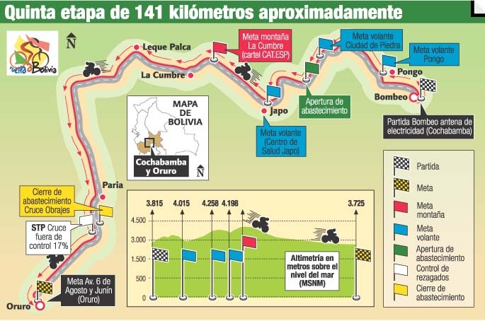
come up with a contingency plan. Not a “well, if the weather is bad” contingency plan, but an actual “if the UCI kick up a fuss” type contingency plan. Because this one is pushing the boundaries, it really is, with a stage that is heading up towards - but not topping - the maximum distance allowable without special dispensation, and not one but two climbs going up above the mythical 4000m altitude, which comes up very, very seldom in racing. In fact, the UCI’s rules are somewhat vague about maximum altitude allowable. The Tour of Qinghai Lake has become known for its stages spending enormous amounts of time at 3500m+, and includes in recent years a summit finish at Dadongshu, or Winter Tree Hill, at over 4100m, but that’s still 350m below our ceiling here. The Vuelta a Bolivia has been over the monolithic
Alto de La Cumbre, 70km at 5% and a max altitude of 4670m, but that was not during its period of UCI sanctioning. When the UCI were sanctioning the race the highest they got was also the Alto de La Cumbre, but was a separate one in Cochabamba Province which tops out at a “mere” 4496m. So I’m pushing it close, but the Bolivians still have me beaten. This Bombeo-Oruro stage was run annually from 2009 to 2013, with Boyacá’s Mauricio Neiza in 2010 the only non-local winner; Juan Cotumba won this stage in 2011, but in 2009, 2012 and 2013 the stage was won by Óscar Soliz, Bolivia’s best ever cyclist, a 58kg pure escalador who is, perhaps unsurprisingly, a specialist at high altitude and who won a lot of races in Colombia, Ecuador and at home from the late 00s to the mid 10s, but is currently awaiting release from a four year suspension for CERA.
Still the reigning and undefeated champion
However, if the UCI looks at the examples I provide and says, “well, Libertine, the thing is… that Bolivian stage is consistently up at 3800m+ so acclimatisation is not as much of an issue as in your stage where you’re climbing up from 1000m to over 4000m… that Qinghai Lake stage starts lower but it’s Unipuerto and short so nothing like as gruelling as your stage going up over 4000m twice… and those races where we have had multiple climbs at high altitude, such as the USA Pro Cycling Challenge, have been with lower max heights and higher minimum heights too, so you should tone it down a little”… you know what? I get it. This stage is probably a bit on the extreme side and, while the Tour of Qinghai Lake does like to throw in the occasional 240km stage, those ones don’t tend to be anything like this brutal. So, for contingency’s sakes I came up with the alternative of cutting off the summit of Balang Shan La and instead going through the Balangshan Tunnel at around 3850m - this shortens the stage by about 20km and also lowers the maximum height reached back into less atypical terrain.

Profile of alternative version
Either way, this is a monster of a stage with a lot of accumulated height gain. We actually head back toward stage 8 finish Dujiangyan to start the stage a little into the foothills of the mountains, in the town of Yingxiu (映秀), at the southern tip of the Ngawa Tibetan and Qiang Autonomous Prefecture, a self-governing division of northwestern Sichuan which was granted that power by the ROC in 1952 and has retained that right ever since. Yingxiu is part of Wenchuan County, and is the gateway from the Chengdu Basin to the Siguniang mountains, the highest peaks in the Qionglai range. The population is small, but that’s largely because it was enormously depopulated following the 2008 earthquake, and with the overall county population being in six figures, the intention is for the town to repopulate in time. It was especially heavily hit by the earthquake seeing as the town was directly at the epicentre and the earthquake hit magnitude 8,0, which categorises it as a “great Earthquake” under the present scaling definitions; the specific site of the epicentre on the surface has been redesigned into a park and monument called Benevolence Square. On that day and in the ensuing clearance, 5.642 people died in the area and 80% of Yingxiu was destroyed. It would be a nice nod to the past to start the stage here, as the town, though small, has that historical significance, as well as being convenient in bringing the stage distance down below the UCI-mandated maximum, of course.
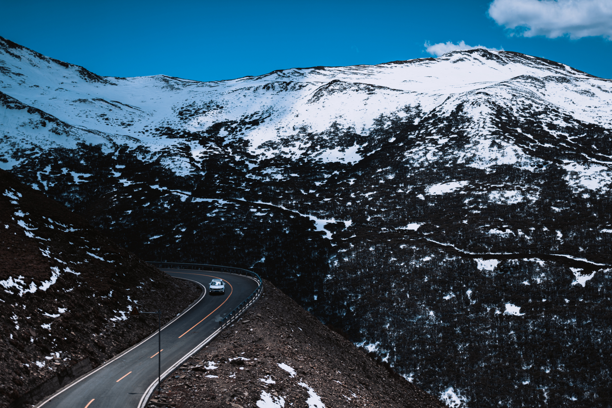
Leaving Yingxiu, the road is already sort-of uphill, but sort-of isn’t. It’s like when you look at those Peruvian climbs that are like, 120km long, and they’re only at 2,5%, and you think ‘that’s not much of a climb’ only to realise that’s about 3000 vertical metres total. This is all slowly turning uphill, but most of this early part of the stage is ascending at, you know, about 1%, so really shouldn’t be counted as ‘climbing’ per se, as it’s just riding through a valley road as we slowly follow the Shaotang River upstream. Eventually, however, the false flat becomes slightly steeper false flat, and then after a while longer the slightly steeper false flat becomes something approximating an actual climb. It’s just the length of the stage makes it look like this is basically 100km of genuine climbing, from the start up to Balangshan La.
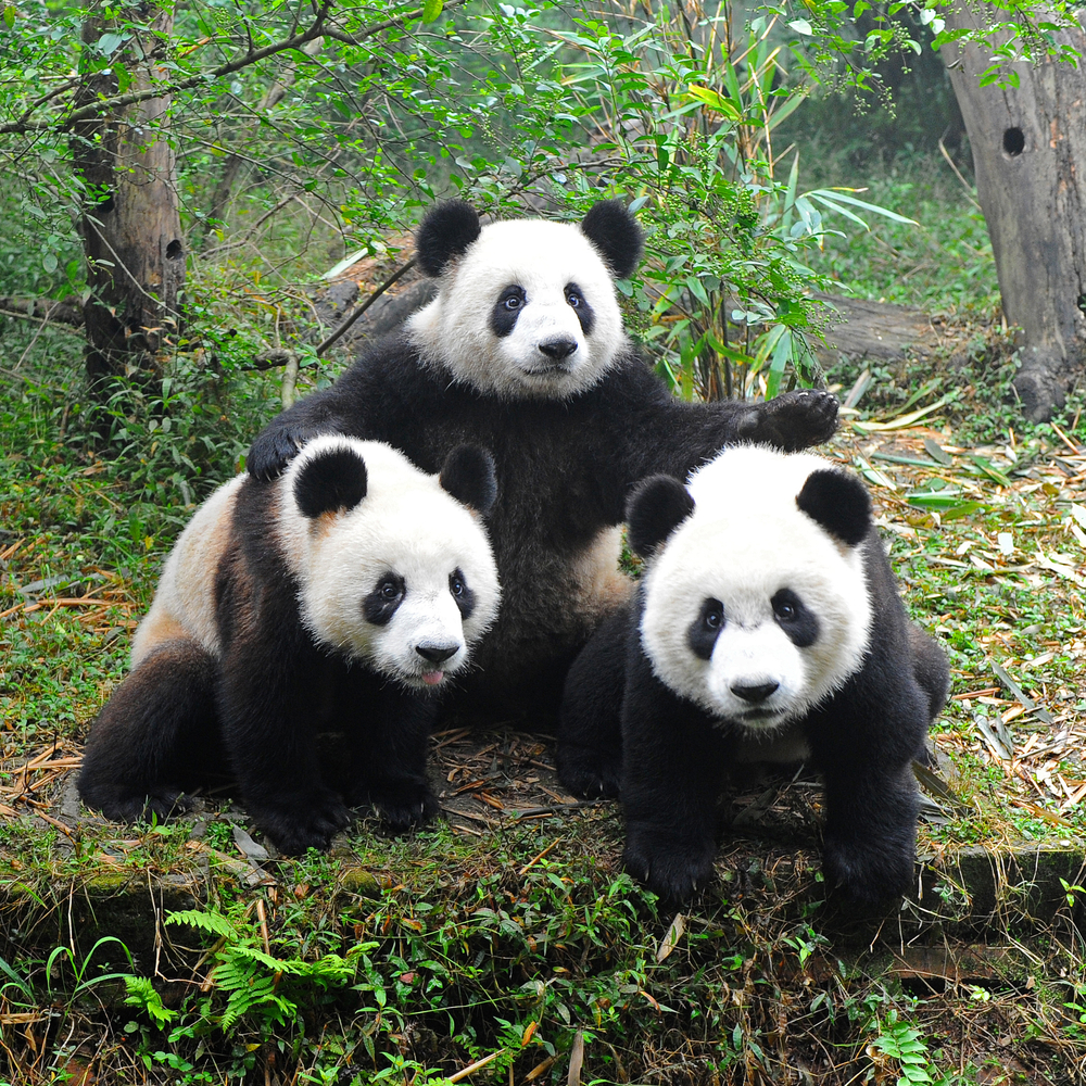
After 33,5km we head through the town of Wolong, which is about 600m higher in altitude than the stage start, so just under 2%. This enters us into the 卧龙自然保护区, or Wòlóng Zìránbǎohùqū in pinyin, which translates to Wolong National Nature Reserve. Established in 1963, there were multiple reasons for the area to be protected. It was then massively expanded in 1975, extended to 10 times its original size, and is an incredibly scenic area of the Qionglai mountains. It preserves over 4.000 species of fauna and attracted over 200.000 annual visitors before the 2008 earthquake damaged access infrastructure. This has now been re-established so the tourist numbers are increasing once more. However, there is one species that, above all others, stands tall as the attraction
par excellence for the Wolong Nature Reserve - and considering that includes endangered species like the snow leopard, that’s one thing. But let’s face it, let’s talk about animals native to China, iconic of Chinese wildlife throughout the world… what animal are we going to talk about?
Panda panda panda panda pan-panda!
Wolong is now one of the UNESCO-inscribed Sichuan Giant Panda Sanctuaries, and since 1980 the World Wildlife Fund and the Chinese government have collaborated on a program to increase captive bred pandas, with the aim of reintroducing more into the wild. This program also loans pandas from the nature reserve to zoos worldwide, as part of the ‘panda diplomacy’. Though we enter the wildlife park and pass the Daxiongmao museum and villa marking the park entrance quite early on, it is a long way up to the specific panda centre for the breeding and research programs. In fact… Balang Panda Kingdom is at nearly 4000m of altitude so if the UCI forces the alternative course on us, we won’t go past the actual base, some 2000m higher up and 55km of road later. Which, yes, averages less than 4%, but then this climb never truly gets steep so to speak, it’s its length and the severe altitude that make this one a killer, totalling 56,5km at 4%. So after we’ve gone far enough that the gradient turns uphill long enough to be considered a genuine climb rather than false flat, the next 15km average 3,3%, then there’s a bit of flat before 38km at 4,6% which is mostly very consistent - only a couple of kilometres in the middle of the climb get up to around 8%, and four separate kilometres late on in the climb average 6% (three of which would be omitted if the short form of the climb is required; the rest of the time this is pretty scenic riding through increasingly thin air. I mean, this is pretty extreme, so I can understand if we get cut off at 3800m to go through the tunnel. Even the
official tours in the region provide oxygen to participants if required at the summit of Balangshan La, although in fairness these will usually be enthusiastic amateurs who want to see the pandas, rather than the likes of Yonathan Monsalve, Ilya Davidenok and Mirsamad Pourseyedi who want to win bike races (yes, I know Monsalve is currently suspended).
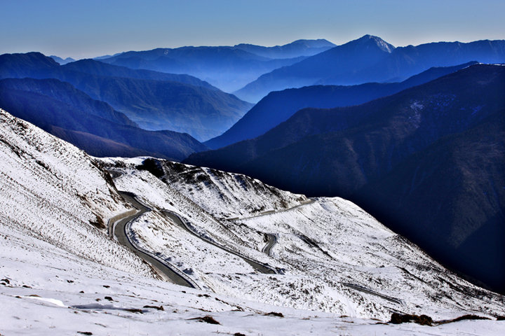
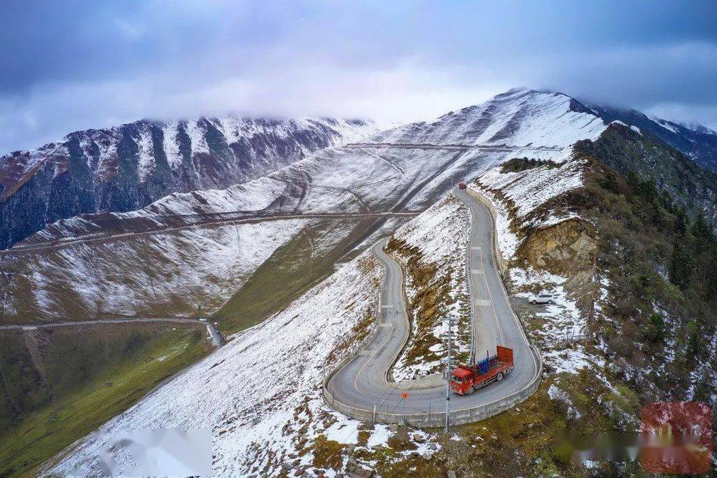
dangerousroads.org suggest that part of the route is unpaved but don’t worry about this - this is covering the full 700km route all the way over to Siguniang, none of the unpaved sections come until after we’ve left the road behind, because the Chinese want to have access to the panda sanctuaries and to encourage the tourist attendance in the area. Balangshan is a Chinese reading of the original Tibetan name (Balang being approximations of the pronunciation of the Tibetan name, and then ‘shan’, Chinese for mountain, is appended, and then La, which is the word for pass in both languages) and means “strange willow mountain”.

If we are forced to top out at 3800m and go through the tunnel, the climb measures in at 43,5km @ 3,8% - but nevertheless despite low gradients, again altitude will be a factor. The UCI has had its concerns about climbs of certain length or altitude in the past, but as mentioned they have sanctioned races going to 4496m with the Vuelta a Bolivia’s run as a UCI-sanctioned race in the late 00s and early 10s, and climbs of absurd length in the Vuelta a Ecuador and with Letras in Colombia. That we’re climbing to this altitude from a fairly ‘normal’ kind of altitude is the extreme thing here, however, and I understand if that is too much for them. Especially as we’re only halfway through the stage here. So realistically, apart from attrition (which I expect there will be plenty of. With stage 9 finishing relatively close to Chengdu, I would not be surprised to see much of the rouleur armada and the less established members of the péloton simply climb off or even just DNS this one), it is likely that we simply see a large breakaway and then the bunch climb over Balangshan La. There’s over 100km remaining and the gradients are low, so survival is the bigger deal for the time being, unless the race organisation committee (consisting of the Sichuan regional government in collaboration with me) decide on some special Cima Coppi-esque prize of monolithic proportions for cresting the highest altitude in a UCI race that year (presuming the Vuelta a Bolivia is not back at UCI-sanctioned level by then - or that I haven’t also been enlisted to design said race by the Bolivians, as that is a race and area I’ve been very tempted by, but lack of paved road options is somewhat restrictive there, and while UCI categorised the race essentially followed the same format each year).

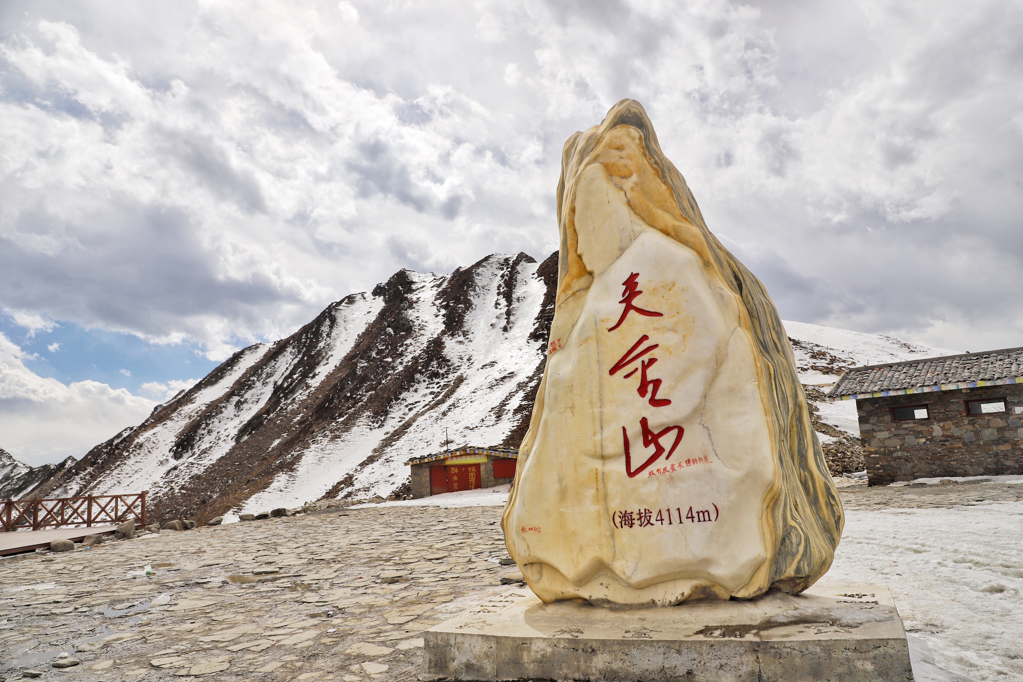
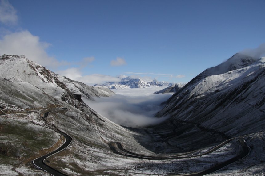
Summit at 4480m
The descent from Balangshan La is actually somewhat steeper than the ascent, but it’s also significantly shorter. The descent is 36km long and averages 4,3%, but does include around 5km at 6% so this lengthy respite will be much appreciated by the riders who have been up to such significant altitude. In the shorter version of the stage it is 21,1km at 4,5%. We have the feed station in the town of Siguniangshan, which takes its name, unsurprisingly, from Siguniang Mountain, a small scenic hill station close to the Siguniang South Gate access point, where the first intermediate sprint takes place. The two intermediate sprints actually follow directly on from one another, with the second being at Daweixiang just 15km after the first. This is largely because there is precious little flat terrain in this behemoth of a stage, and also because I didn’t want to leave the intermediate sprints right until the very end and kill any hope for the breakaway of getting anything out of the day.
At Daweixiang, we turn left and move away from the Siguniang road to take on Jiajinshan La, the mountain pass over Jiajin mountain, the final HC mountain of the stage and of the race as a whole. The other two mountain stages were Unipuerto, so this one is a bit of a shock to the system and a change of pace for the péloton as this is more savagery, albeit once more it’s low gradient grinding for the most part (there is a steep kilometre near the bottom, though Cronoescalada has exaggerated this from the more realistic 9-10% up to 15% due to the issues of where the roads line up to the contour lines in mapping the People’s Republic). The Jiajinshan La climb again only averages 4,5%, but is 29,5km in length and tops out just under 4100m in altitude. However, much more helpfully for the riders this time, we’re starting from nearly 2800m and so the suffering is much more limited, as well as, having already been up over 4000m once in the stage the extent of the impact of the thinning air while ascending is likely to be less significant than when we were climbing from 1300m at the start as the altitude difference is less enormous.
While some climbs of low average gradient hide their brutality, such as La Marta, Cálar Alto from Tijola, Torre or Croix de Fer, this one is fairly open with you - the problem here is the altitude and the oxygen debt, not just the gradients, as this doesn’t get especially steep, in fact other than that bit at the start, the steepest stretches are 3,3km at 6% near the bottom, and 1,6km at 7% in the middle. The last 9km average 5% on the money, and I would expect we’re going to see attrition break this one up into ones and twos just from distance and altitude by the time we reach the summit, which comes at 57km from the line, almost all of which is downhill. The Mount Jiajin (Jiajinshan) Scenic Park (夹金山风景名胜区) is also inscribed within the UNESCO World Heritage Site for the Giant Panda Sanctuaries (there are seven nature reserves and nine scenic areas connected under this), but unlike Balangshan there is no specific sanctuary/centre, it’s more a protected area.
Dangerous Roads’ profile of this one describes it as a road to drive at least once, and that it is open all year round most years. And it’s a beauty of a road, too.
Summit
And with that, an epic descent begins. Over the next 45km we will descend 1900m at an average of just over 4%, with the steepest parts at the beginning. The descent is no less scenic than the ascent but comes with the advantage that this part of the stage is much more likely to be televised. After all, you can watch
coverage of the Tour of Fuzhou, so this should be establish-able as a race that can get some reasonable coverage, at least for selected stages as is sometimes the case in some races, and let’s face it, stages 6, 7 and 10 are the obvious choices in that respect.
Believe it or not, we’re only scratching the surface of the climbs in the Qionglai range, but ultimately, these mountains are pretty sparsely populated, and the best alternative option was Bailongchi lake in the valley of the Min river to the northeast. And to be honest, I didn’t want another MTF. Both mountain stages have been Unipuerto thus far, whereas I wanted a stage where the racing would be entirely different to that. And while this stage is perhaps a bit excessive, it is worth noting that the Tour of Qinghai Lake does include
stages with climbs as difficult as this at 3750m, and although a bit easier than my stage, also includes
225km+ mountain stages. The Tour de Singkarak and the Tour of Iran-Azerbaijan have also included 200km+ mountain stages on the Asia Tour in recent years, and since I am essentially proposing a Qinghai Lake replacement, a long stage race to compete in grandiosity and be a late-season counterpart to Langkawi to provide UCI Asia Tour pseudo-Grand Tours in a part of China which is both economically strong and growing, culturally rich and geographically diverse enough to support long-form stage racing, I feel this is acceptable - just. Possibly with the tunnel use because I’m still a bit unsure about that 4480m ceiling at Balangshan La.
The descent largely follows the Donghe River, through Fengtongzhai Nature Reserve (蜂桶寨自然保护区), one of the seven reserves included in the UNESCO World Heritage Site, which is also a popular breeding site for the other species of panda, the much smaller
Red Panda, which despite the name is not at all related to the big fuzzy black and white things that you and I will think of whenever anybody mentions the word “panda”. Around Qiaoqixiang, a dam has been constructed on the river, leaving a large reservoir which the riders will arrive at the edges of at around 15km from home. Around 10km of looping around the reservoir (ignore the significant dip in the profile, that is where we cross the dam itself, so it’s the usual cycling profile builder problem with bridges and tunnels) lead us to a final uphill kicker.
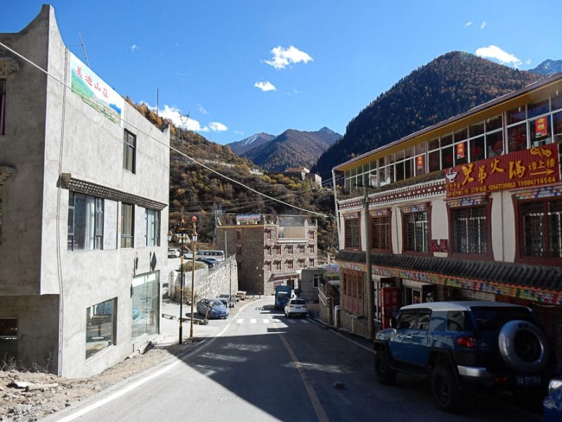
The final ramp is up a short, punchy climb to the Nibagou Scenic Area, a spa resort built into a valley adjacent to the Donghe.
Image from Petra Spohn - entrance to Nibagou Scenic Area
2,6km at 8,5% is a very generous second category, but in keeping with the climbs from stages 1 and 2 that got that status. But pretty minuscule in comparison to the first two climbs of the day, even if significantly steeper. However, we’re deep into Aprica terrain here, where the easier climb opens up huge gaps just because of the sheer pain of going uphill once more after such a tough previous climb. Yet here it’s kind of the reverse of the usual Race Design Thread “Aprica Theory” stratagem - here, rather than being “hard climb-easy climb” where the first climb is steep and the second climb either short, shallow or both, here instead it’s a long and gradual climb followed by a short and steep one, and the real difficulty in the gradual climb comes from its altitude. After all, it’s not every day you finish at nearly 2400m and it’s a barely perceptible uphill that finishes the day. I mean, what’s the nearest you can manage to that in Europe? Sant’Anna di Vinadio? It’s at 2015m and can only be off the back of a short descent after the Col de la Lombarde. Places like Pra Loup and Auron are only at 1600m so don’t have the altitude factor. Colombia has probably a few, such as some of the routes into Manizales after the Alto de Letras, but nevertheless, this is very much an unusual and almost unique (certainily on the Asia Tour) style of stage which makes a more than worthy - possibly
too worthy - queen stage. The last two days of the race will be far, far easier and just surviving this one will be enough for much of the péloton.