
Race Design Thread
Page 238 - Get up to date with the latest news, scores & standings from the Cycling News Community.
You are using an out of date browser. It may not display this or other websites correctly.
You should upgrade or use an alternative browser.
You should upgrade or use an alternative browser.
- Feb 20, 2010
- 33,248
- 15,771
- 28,180
Fleur designed some national championships courses back in the early days of the thread as well (Portugal in Coimbra I seem to recall) but it's been a while. The more the merrier!
To start, I apologise for the delay  .
.
Paris-Nice
Stage 5: Bourg-Argental - Mont Ventoux (Chalet Reynard) (198km)
http://www.la-flamme-rouge.eu/maps/viewtrack/hd/79186

A true MTF. The riders leave from Bourg-Argental, a small commune in the Loire, and head south-east, towards Valence. Having passed the city, they meet the feed zone, and after that a cat. 3 climb; the Côte d'Aleyrac. After this, there are the two intermediate sprints, in Vaison-la-Romaine and Malaucene. Located not far from the line, they will hopefully give an opportunity for GC riders to try and gain back time or increase their lead.
But then starts the challenge of the day; Mont Ventoux. Climbed from Bedoin, as always, it averages 8.4% over is 12.8km, and will pose a challenge. You can argue that the lack of climbing before it will minimise GC action, but I simply wanted a challenging MTF in my race, and it will go well after the queen stage the day before. Further, the next stage will be relatively flat, so the favourites will have nothing to lose. As at the 2016 Tour, the line is at Chalet Reynard, at an altitude of 1426m. A chance to gain time, and win on le mont Chauve.
Start
Bourg-Argental, Place de la Cite (km0 is at Puy-Loriol, on the D820)
Finish
Mont Ventoux (Chalet Reynard), D974
Climbs
Côte d'Aleyrac (6.6 Km at 4%, cat. 3),
Chalet Reynard (12.8 Km at 8.4%, cat. 1)
Sprints
Vaison-la-Romaine
Malaucene
The next stage
Relatively flat, but unlikely to go to the sprinters...
PS: I added the profiles to the individual stages here, to make viewing them more clearer.
.Paris-Nice
Stage 5: Bourg-Argental - Mont Ventoux (Chalet Reynard) (198km)
http://www.la-flamme-rouge.eu/maps/viewtrack/hd/79186
A true MTF. The riders leave from Bourg-Argental, a small commune in the Loire, and head south-east, towards Valence. Having passed the city, they meet the feed zone, and after that a cat. 3 climb; the Côte d'Aleyrac. After this, there are the two intermediate sprints, in Vaison-la-Romaine and Malaucene. Located not far from the line, they will hopefully give an opportunity for GC riders to try and gain back time or increase their lead.
But then starts the challenge of the day; Mont Ventoux. Climbed from Bedoin, as always, it averages 8.4% over is 12.8km, and will pose a challenge. You can argue that the lack of climbing before it will minimise GC action, but I simply wanted a challenging MTF in my race, and it will go well after the queen stage the day before. Further, the next stage will be relatively flat, so the favourites will have nothing to lose. As at the 2016 Tour, the line is at Chalet Reynard, at an altitude of 1426m. A chance to gain time, and win on le mont Chauve.
Start
Bourg-Argental, Place de la Cite (km0 is at Puy-Loriol, on the D820)
Finish
Mont Ventoux (Chalet Reynard), D974
Climbs
Côte d'Aleyrac (6.6 Km at 4%, cat. 3),
Chalet Reynard (12.8 Km at 8.4%, cat. 1)
Sprints
Vaison-la-Romaine
Malaucene
The next stage
Relatively flat, but unlikely to go to the sprinters...
PS: I added the profiles to the individual stages here, to make viewing them more clearer.
- Jun 30, 2014
- 7,060
- 2
- 0
Giro dell' Euregio stage 3: Zirl – Lienz; 194km


This is going to be the easiest stage of my Giro dell' Euregio, it's a transitional stage.
The stage starts in Zirl and after 70km of flat the first climb of the day starts, the Gerlospass, 24.6km at 3.9%.

As you can see it's an irregular climb with a decent start, a long section of false flat in the middle and a few steeper sections near the end.
After the descent we have around 30km of false flat, then the 2nd climb of the day, Felbertauern from North, starts, 16.3km at 5%.

On top of the Climb the riders will ride through the almost 5.3km long Felbertauerntunnel, then a rather gentle descent starts.
The descent ends with 19km to go, the rest of the stage is just false flat and will finish in Lienz, a town that is known (at least among cycling fans) for the many hard climbs that surround it. If you like watching Alpine Skiing you'll probably know Lienz because of the Women's World Cup races (Giant Slalom and Slalom)
This one should go to the breakaway, but it's the only stage for the sprinters who can climb, so maybe one team will actually take control to bring it all back together, the main problem is that most team probably wouldn't bring a sprinter to a climbers race like this one, maybe a really fast allrounder like Felline could win the stage (yes, I know that he's not exactly a guy who wins many races, but he beat Matthews on that one Pais Vasco stage in 2015).
Zirl:

Lienz:

This is going to be the easiest stage of my Giro dell' Euregio, it's a transitional stage.
The stage starts in Zirl and after 70km of flat the first climb of the day starts, the Gerlospass, 24.6km at 3.9%.
As you can see it's an irregular climb with a decent start, a long section of false flat in the middle and a few steeper sections near the end.
After the descent we have around 30km of false flat, then the 2nd climb of the day, Felbertauern from North, starts, 16.3km at 5%.
On top of the Climb the riders will ride through the almost 5.3km long Felbertauerntunnel, then a rather gentle descent starts.
The descent ends with 19km to go, the rest of the stage is just false flat and will finish in Lienz, a town that is known (at least among cycling fans) for the many hard climbs that surround it. If you like watching Alpine Skiing you'll probably know Lienz because of the Women's World Cup races (Giant Slalom and Slalom)
This one should go to the breakaway, but it's the only stage for the sprinters who can climb, so maybe one team will actually take control to bring it all back together, the main problem is that most team probably wouldn't bring a sprinter to a climbers race like this one, maybe a really fast allrounder like Felline could win the stage (yes, I know that he's not exactly a guy who wins many races, but he beat Matthews on that one Pais Vasco stage in 2015).
Zirl:
Lienz:
- Feb 20, 2010
- 33,248
- 15,771
- 28,180
Stage 3: Ussuriysk - Ussuriysk, 149km


The fourth stage (third road stage) and penultimate day of the GP Primorsky Krai is not the most exciting from a parcours point of view, circling Ussuriysk, a city of around 150.000 people which lies around 100km north of Vladivostok.

Because of its convenient location on the railroad route between Khabarovsk and Vladivostok, the former trading outpost of Nikolskoye-Ussuriysk (St. Nicholas' town on the Ussuri river) abbreviated its name to Nikolsk-Ussuriysk, and grew rapidly following the completion of the Trans-Siberian railway, with many agricultural products being churned out by its developing manufacturing sector, and growth was only exacerbated following the rise to power of the Communists, as its factories helped keep much of the Russian Far East in stock of numerous such products. Being inland, unlike the other cities of the region, Nikolsk-Ussuriysk was never as dependent on import, nor was its prosperity so intrinsically linked to Soviet military and maritime industries as Vladivostok or Nakhodka. The city was named Voroshilov in honour of Kliment in 1935, however during the period of de-Stalinization, with many of his inner circle now personae non grata and many of the city names given in honour of prominent supporters by Stalin being revoked, the present name for the city was adopted.

Ussuriysk has another, somewhat stranger claim to fame, however; it is the setting of the cult TV show Spets (Спец), one of the most bizarre back-stories that a TV show must ever have had. This ultra low-budget, low-res gritty serial chronicled the lives of small town gangsters in the Russian Far East, focusing primarily on podstava groups using the region's importance for importing Japanese vehicles into Russia and Europe to create blackmail and extortion rackets often centering around staged or forced road accidents, with Ussuriysk serving as its epicentre. The reason it is so unusual is because the series came about because a real life Russian Far East gangster, Vitaly Dyomochka, was unhappy about the unrealistic way gangsters were being portrayed in TV and film at the time, so set out to right this by filming a series based on his own personal experiences; however getting experienced film crews and directors out into Primorsky Krai to film on next to no budget proved nigh on impossible, so Dyomochka basically did everything himself, directing, filming, writing and starring in the show, even going to the extent of actually cutting himself open for several scenes where blood was required on screen.
Why am I wittering on about Stalinist generals and low-budget crime dramas? Well, because the stage is an easy one, in the hope that this will entice riders to make a bit more of yesterday's stage. It consists of a rolling loop around the city for the first half, including one small categorized climb, before five laps of a pan-flat 13km circuit which finishes in the square depicted above. This should be wide open and comfortable for the sprinters, even in these smaller .1 races on the Europe Tour and/or Asia Tour races, and enable riders to save energy ahead of the queen stage tomorrow.
The fourth stage (third road stage) and penultimate day of the GP Primorsky Krai is not the most exciting from a parcours point of view, circling Ussuriysk, a city of around 150.000 people which lies around 100km north of Vladivostok.
Because of its convenient location on the railroad route between Khabarovsk and Vladivostok, the former trading outpost of Nikolskoye-Ussuriysk (St. Nicholas' town on the Ussuri river) abbreviated its name to Nikolsk-Ussuriysk, and grew rapidly following the completion of the Trans-Siberian railway, with many agricultural products being churned out by its developing manufacturing sector, and growth was only exacerbated following the rise to power of the Communists, as its factories helped keep much of the Russian Far East in stock of numerous such products. Being inland, unlike the other cities of the region, Nikolsk-Ussuriysk was never as dependent on import, nor was its prosperity so intrinsically linked to Soviet military and maritime industries as Vladivostok or Nakhodka. The city was named Voroshilov in honour of Kliment in 1935, however during the period of de-Stalinization, with many of his inner circle now personae non grata and many of the city names given in honour of prominent supporters by Stalin being revoked, the present name for the city was adopted.
Ussuriysk has another, somewhat stranger claim to fame, however; it is the setting of the cult TV show Spets (Спец), one of the most bizarre back-stories that a TV show must ever have had. This ultra low-budget, low-res gritty serial chronicled the lives of small town gangsters in the Russian Far East, focusing primarily on podstava groups using the region's importance for importing Japanese vehicles into Russia and Europe to create blackmail and extortion rackets often centering around staged or forced road accidents, with Ussuriysk serving as its epicentre. The reason it is so unusual is because the series came about because a real life Russian Far East gangster, Vitaly Dyomochka, was unhappy about the unrealistic way gangsters were being portrayed in TV and film at the time, so set out to right this by filming a series based on his own personal experiences; however getting experienced film crews and directors out into Primorsky Krai to film on next to no budget proved nigh on impossible, so Dyomochka basically did everything himself, directing, filming, writing and starring in the show, even going to the extent of actually cutting himself open for several scenes where blood was required on screen.
Why am I wittering on about Stalinist generals and low-budget crime dramas? Well, because the stage is an easy one, in the hope that this will entice riders to make a bit more of yesterday's stage. It consists of a rolling loop around the city for the first half, including one small categorized climb, before five laps of a pan-flat 13km circuit which finishes in the square depicted above. This should be wide open and comfortable for the sprinters, even in these smaller .1 races on the Europe Tour and/or Asia Tour races, and enable riders to save energy ahead of the queen stage tomorrow.
Volta a Portugal
Stage 12: Braga – Porto (149km)


In Portugal is time for a flat stage, after two days of mountains that could finish the GC…or not.
Stage 12 is short generally pan flat, but not everything will be easy. Stage starts in Braga, meaning no transfers happened. From Braga in the interior, riders will ride in direction to the coastline, in particular Esposende. From Esposende to Matosinhos, the route will follow coastal roads, tha are very exposed to the wind. In the North Coast of Portugal there are a lot of windy days, namely in August when we have the “Nortadas”, the name given to cold winds from Northeast. Because of this, echelons are possible in this stage.

exposed roads
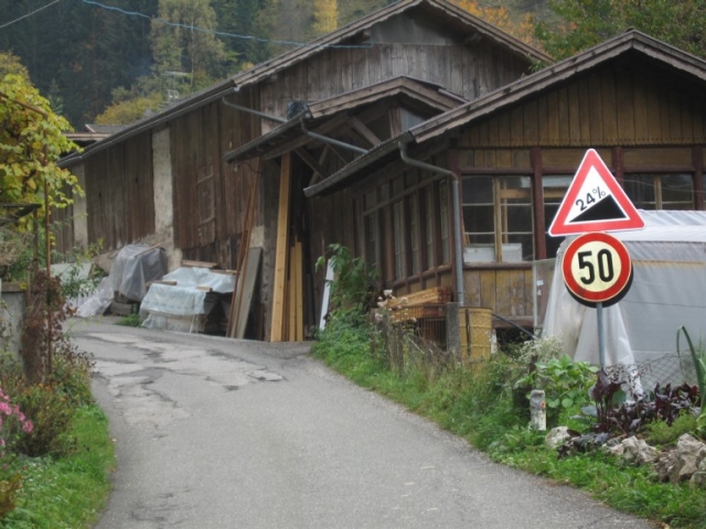
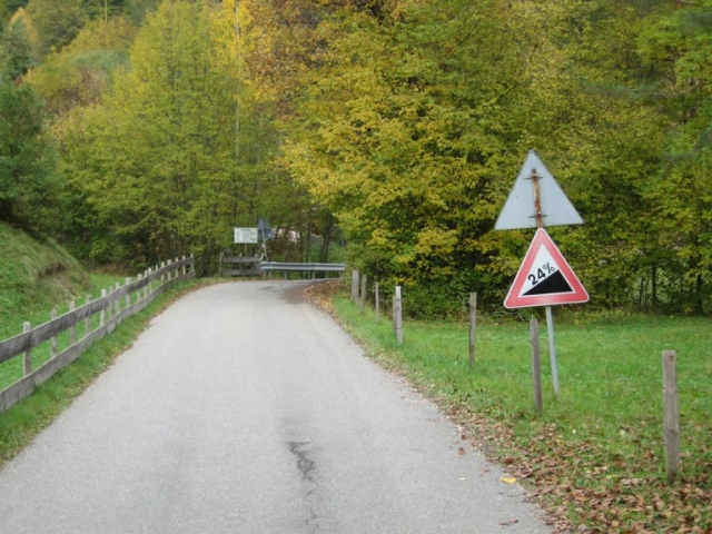
But not only wind will be a surprise for some riders, there is also present a cobble section of 4.2km between the villages of Apúlia and Fão (see image). If there are echelons at that time, with cobbles, will not be easy to recover position in the main group.

In Matosinhos, there is a change of direction to the interior, with passages in Maia and Gondomar. Reached Crestuma dam, riders will go in direction to Porto, in the Douro margin. They enter in the city of Porto through Rotunda do Freixo, following the road in the river margin (Avenida Gustavo Eiffel). Already in full historical centre, after Ribeira tunnel, riders will turn right to Rua Mouzinho da Silveira in direction to Avenida dos Aliados, where is placed the finish line. This section (Mouzinho-Aliados) is cobbled and the road is uphill (900m 4% max.7%).

In this stage maybe you can’t win a competition but you can lose it.
Stage 12: Braga – Porto (149km)
In Portugal is time for a flat stage, after two days of mountains that could finish the GC…or not.
Stage 12 is short generally pan flat, but not everything will be easy. Stage starts in Braga, meaning no transfers happened. From Braga in the interior, riders will ride in direction to the coastline, in particular Esposende. From Esposende to Matosinhos, the route will follow coastal roads, tha are very exposed to the wind. In the North Coast of Portugal there are a lot of windy days, namely in August when we have the “Nortadas”, the name given to cold winds from Northeast. Because of this, echelons are possible in this stage.
exposed roads
But not only wind will be a surprise for some riders, there is also present a cobble section of 4.2km between the villages of Apúlia and Fão (see image). If there are echelons at that time, with cobbles, will not be easy to recover position in the main group.
In Matosinhos, there is a change of direction to the interior, with passages in Maia and Gondomar. Reached Crestuma dam, riders will go in direction to Porto, in the Douro margin. They enter in the city of Porto through Rotunda do Freixo, following the road in the river margin (Avenida Gustavo Eiffel). Already in full historical centre, after Ribeira tunnel, riders will turn right to Rua Mouzinho da Silveira in direction to Avenida dos Aliados, where is placed the finish line. This section (Mouzinho-Aliados) is cobbled and the road is uphill (900m 4% max.7%).
In this stage maybe you can’t win a competition but you can lose it.
- Feb 20, 2010
- 33,248
- 15,771
- 28,180
Stage 4: Vladivostok - Vladivostok, 177km


The final stage of the GP Primorskogo Kraya/GP Primorsky Krai is the queen stage, consisting of five laps of a difficult hilly circuit of 35,4km in the region's capital and largest city, Vladivostok.
The start/finish is the same as the finishing line from the prologue, on the north side of Central Square on Svetlanskaya Ulitsa, but the course here is much more difficult, including no fewer than five climbs, three of which are categorized (and the other two aren't all that pleasant either) on each circuit, so there's a good chance that either the GPM will be sorted today from the break, or aggression in the last couple of laps will see the riders who were at the forefront in the Nakhodka stage take it as they duke out the GC. This is the finish, with the riders heading towards the camera:

The first climb of the circuit is on Volodarskogo, the same climb as in the prologue, although from a slightly different approach, which makes it a grand 1km at 8,6%. It crests just 2,4km into the circuit, so the final time the riders pass the summit, 33km will remain.

However, whereas in the prologue the riders continued onto Ulitsa Sukhanova, here they swing right and then take a sweeping spooner curve to the left onto one of Vladivostok's most recognizable icons, the Золотой Мост (Golden Bridge) which crosses Бухта Золотой Рог (Zolotoy Rog "Golden Horn" Bay), built for the 2012 APEC summit held in the city. At 750m it is dwarfed by its southern neighbour, Russky Bridge, which connects Russky Island to the Asian mainland and is the longest cable-stayed bridge in the world, however unlike Russky Bridge Zolotoy Most is not just within the boundaries of Vladivostok but is within the city centre itself.
After a fast, sweeping flat section along Ulitsa Kalinina the riders reach the easternmost tip of the bay, whereupon they head uphill into Leninskiy Rayon, along Ladygina, the most sustained and difficult climb of the circuit, at 2,5km averaging 6,8% including ramps of up to 15%. The final time the riders crest this there will be 22,6km remaining.

This leads to a further two claims chained directly into one another, as we leave the city's immediate bounds to the north and head into the foothills.

The first of these two climbs is on Vyselkovaya, 1500m at just under 7%, although on a fairly wide open road so perhaps not as conducive to attacks as the previous two climbs. Nevertheless, with 17,9km remaining to the line and a very short descent that ends with a tight left-right chicane leading us onto the following climb, it could have an effect, especially in consolidating a lead or hurting the chase if somebody has gone on Ladygina. It is followed immediately by the second of the uncategorized climbs on the circuit, Dneprovskaya, which is in terms of gradient easily the easiest of the climbs on the circuit, staying mostly around the 4-5% mark and only having a max of 9%, although coming with almost exactly 14km remaining it will also be a very frustrating section of course for those trying to chase back on, as a frustrating, leg-sapping drag.


The descent from here is very technical which will also up the challenge as it will make it harder for chasers to keep sight of their targets, and then the road straightens out along a riverside for a little before we cross the ridge of hills back to the city centre once more via the climb which is both the shortest and the steepest on the course, the 600m at over 12% that is Kotelnikova.


The nearest thing I can think of for this climb is the final ramp in the Firenze World Championships, which came around 5km from the line; this comes 6,3km from the line but at the same time smaller teams, a wider range of rider levels and the fact that the course includes four other climbs (it's less chained together than the Firenze Worlds, but the sheer number of climbs ought to wreak havoc on the .1/.2 kind of field we're going to be drawing here) mean the style of racing produced on that climb may be representative of what we can expect. Apart from a short initial section, however, most of that 6,3km is on wide open roads which will favour the group behind, so riders who want to make this stage count will need to put pressure on opposition domestiques, less climbing-adept riders in the upper echelons of the GC and less adept descenders earlier in the course for it to count.
As a result, I think we could be in for a really intriguing stage here, because the circuit itself has features that would favour the chasing group, but with 15 climbs over 177km the group really ought to be shorn of a lot of less adept climbers and so we should see groups of elite puncheurs fighting this out, if they don't want to get Gerransed...

The final stage of the GP Primorskogo Kraya/GP Primorsky Krai is the queen stage, consisting of five laps of a difficult hilly circuit of 35,4km in the region's capital and largest city, Vladivostok.
The start/finish is the same as the finishing line from the prologue, on the north side of Central Square on Svetlanskaya Ulitsa, but the course here is much more difficult, including no fewer than five climbs, three of which are categorized (and the other two aren't all that pleasant either) on each circuit, so there's a good chance that either the GPM will be sorted today from the break, or aggression in the last couple of laps will see the riders who were at the forefront in the Nakhodka stage take it as they duke out the GC. This is the finish, with the riders heading towards the camera:
The first climb of the circuit is on Volodarskogo, the same climb as in the prologue, although from a slightly different approach, which makes it a grand 1km at 8,6%. It crests just 2,4km into the circuit, so the final time the riders pass the summit, 33km will remain.
However, whereas in the prologue the riders continued onto Ulitsa Sukhanova, here they swing right and then take a sweeping spooner curve to the left onto one of Vladivostok's most recognizable icons, the Золотой Мост (Golden Bridge) which crosses Бухта Золотой Рог (Zolotoy Rog "Golden Horn" Bay), built for the 2012 APEC summit held in the city. At 750m it is dwarfed by its southern neighbour, Russky Bridge, which connects Russky Island to the Asian mainland and is the longest cable-stayed bridge in the world, however unlike Russky Bridge Zolotoy Most is not just within the boundaries of Vladivostok but is within the city centre itself.
After a fast, sweeping flat section along Ulitsa Kalinina the riders reach the easternmost tip of the bay, whereupon they head uphill into Leninskiy Rayon, along Ladygina, the most sustained and difficult climb of the circuit, at 2,5km averaging 6,8% including ramps of up to 15%. The final time the riders crest this there will be 22,6km remaining.
This leads to a further two claims chained directly into one another, as we leave the city's immediate bounds to the north and head into the foothills.
The first of these two climbs is on Vyselkovaya, 1500m at just under 7%, although on a fairly wide open road so perhaps not as conducive to attacks as the previous two climbs. Nevertheless, with 17,9km remaining to the line and a very short descent that ends with a tight left-right chicane leading us onto the following climb, it could have an effect, especially in consolidating a lead or hurting the chase if somebody has gone on Ladygina. It is followed immediately by the second of the uncategorized climbs on the circuit, Dneprovskaya, which is in terms of gradient easily the easiest of the climbs on the circuit, staying mostly around the 4-5% mark and only having a max of 9%, although coming with almost exactly 14km remaining it will also be a very frustrating section of course for those trying to chase back on, as a frustrating, leg-sapping drag.
The descent from here is very technical which will also up the challenge as it will make it harder for chasers to keep sight of their targets, and then the road straightens out along a riverside for a little before we cross the ridge of hills back to the city centre once more via the climb which is both the shortest and the steepest on the course, the 600m at over 12% that is Kotelnikova.
The nearest thing I can think of for this climb is the final ramp in the Firenze World Championships, which came around 5km from the line; this comes 6,3km from the line but at the same time smaller teams, a wider range of rider levels and the fact that the course includes four other climbs (it's less chained together than the Firenze Worlds, but the sheer number of climbs ought to wreak havoc on the .1/.2 kind of field we're going to be drawing here) mean the style of racing produced on that climb may be representative of what we can expect. Apart from a short initial section, however, most of that 6,3km is on wide open roads which will favour the group behind, so riders who want to make this stage count will need to put pressure on opposition domestiques, less climbing-adept riders in the upper echelons of the GC and less adept descenders earlier in the course for it to count.
As a result, I think we could be in for a really intriguing stage here, because the circuit itself has features that would favour the chasing group, but with 15 climbs over 177km the group really ought to be shorn of a lot of less adept climbers and so we should see groups of elite puncheurs fighting this out, if they don't want to get Gerransed...
- Feb 20, 2010
- 33,248
- 15,771
- 28,180


- Jun 30, 2014
- 7,060
- 2
- 0
Giro dell' Euregio stage 4: Lienz – Nigerpass/Passo Nigra; 188.8km


After a rather easy transitional stage the riders will have to deal with a hard MTF.
The stage starts in Lienz and durning the first 80km of the stage the riders will ride through the Puster Valley, it's mostly false flat and a bit of slightly rolling terrain.
After leaving the Puster Valley we have a few km that go slightly uphill (the average gradient stays below 4%, so I wouldn't call it a climb) that will bring the riders up to Natz, a small Village mostly known for the now abbandoned NATO military base.

The first real climb starts after 122km, it's Pontives from Lajen, 12.7km at 5.3%, it's a rather easy climb and pretty much a tempo grinder.
The following descent isn't very technical, but right after it the next climb already starts, Telfen/Lanzin, 6.1km at 9.5%, a rather short, steep climb .
The first 8.5km of the descent are rather gentle and more of a power descent, the final 7 km are steeper.
Right after the descent the final climb of the day starts, it's the Nigerpass/Passo Nigra from Blumau from it's hardest side, 18.9km at 7.2%.

The one thing that makes this climb so hard is the first steep section before the false flat on the old road, 1km at 16%, two 24% steep ramps and another 20% ramp, after a tempogrinder and a short, steep climb that's a real legbreaker that could already break a few riders and take care of a decent amount of the domestiques.

The 2nd steep section of the climb after the false flat is still steep, but it lacks those ungodly steep ramps that make the first part of the climb so hard.
The stage will end 200-300m before the actual Pass, the reason behind it is rather simple, here we have a decent sized parking Lot that could actually host a stage finish, otherwise you'd have to finish 3km after the actual pass (those 3km would be about 4% steep).
This is the final hard MTF of the race, the final stage will still feature a few decent climbs, but it won't feature a MTF and it will be a shorter stage.
The Nigerpass/Passo Nigra is a climb that works pretty well as a MTF, like many other great climbs around the Valley it's a rather unkown climb that we don't get to see in the Giro, but I think that it's a great climb that would deserve a spot in an important race, maybe the road on the first half of this side of the Climb is too narrow for the Giro, but it would be reasonable to use in in the Giro del Trentino/Giro dell' Euregio, you could also use it as a penultimate climb before Passo di Lavazè and have a descent finish, that would be an awesome stage.
Nigerpass/Passo Nigra:


After a rather easy transitional stage the riders will have to deal with a hard MTF.
The stage starts in Lienz and durning the first 80km of the stage the riders will ride through the Puster Valley, it's mostly false flat and a bit of slightly rolling terrain.
After leaving the Puster Valley we have a few km that go slightly uphill (the average gradient stays below 4%, so I wouldn't call it a climb) that will bring the riders up to Natz, a small Village mostly known for the now abbandoned NATO military base.
The first real climb starts after 122km, it's Pontives from Lajen, 12.7km at 5.3%, it's a rather easy climb and pretty much a tempo grinder.
The following descent isn't very technical, but right after it the next climb already starts, Telfen/Lanzin, 6.1km at 9.5%, a rather short, steep climb .
The first 8.5km of the descent are rather gentle and more of a power descent, the final 7 km are steeper.
Right after the descent the final climb of the day starts, it's the Nigerpass/Passo Nigra from Blumau from it's hardest side, 18.9km at 7.2%.
The one thing that makes this climb so hard is the first steep section before the false flat on the old road, 1km at 16%, two 24% steep ramps and another 20% ramp, after a tempogrinder and a short, steep climb that's a real legbreaker that could already break a few riders and take care of a decent amount of the domestiques.
The 2nd steep section of the climb after the false flat is still steep, but it lacks those ungodly steep ramps that make the first part of the climb so hard.
The stage will end 200-300m before the actual Pass, the reason behind it is rather simple, here we have a decent sized parking Lot that could actually host a stage finish, otherwise you'd have to finish 3km after the actual pass (those 3km would be about 4% steep).
This is the final hard MTF of the race, the final stage will still feature a few decent climbs, but it won't feature a MTF and it will be a shorter stage.
The Nigerpass/Passo Nigra is a climb that works pretty well as a MTF, like many other great climbs around the Valley it's a rather unkown climb that we don't get to see in the Giro, but I think that it's a great climb that would deserve a spot in an important race, maybe the road on the first half of this side of the Climb is too narrow for the Giro, but it would be reasonable to use in in the Giro del Trentino/Giro dell' Euregio, you could also use it as a penultimate climb before Passo di Lavazè and have a descent finish, that would be an awesome stage.
Nigerpass/Passo Nigra:
Volta a Portugal
Stage 13: Afurada - Espinho (15km) ITT


The penultimate stage of this race is a short ITT, the second of the competition. The stage will be raced in the coast, in a region known by the quality of the beaches, which every year receive the Blu Flag of quality. The route is pan flat, excepting a small ascent in the first km, allowing specialists to gain some time to the climbers (for the GC).

Stage 13: Afurada - Espinho (15km) ITT
The penultimate stage of this race is a short ITT, the second of the competition. The stage will be raced in the coast, in a region known by the quality of the beaches, which every year receive the Blu Flag of quality. The route is pan flat, excepting a small ascent in the first km, allowing specialists to gain some time to the climbers (for the GC).
Pacific Tour
Stage 18 Cheyenne- Loveland 174 km Mountains


Today is the first of four mountain stages and the final mountain top finish of the race. The stage starts in Cheyenne, WY and finished outside of Loveland, Colorado. The first part of the stage is a straight run across the border to Fort Collins. From there the riders climb Rist Canyon. It is not a difficult climb but always seems to drag on so more mentally tough then physically demanding but we are deep into the race and a team could decide to set a hard pace to get rid of the domestiques. This would be done on the few steeper ramps halfway up and towards the top. After a gradual descent into the outskirts of the Loveland area, the race makes a loop by the Carter Lake Reservoir. The final climb of Pole Hill, known as the snake by some locals is short at 5.4 kilometers but the grades in the middle should split the race. It could pay to go all in at the bottom because 5.4 km isn’t that long of an effort. The final 500 meters is downhill so any gaps created on the 9% will stick until the finish. This stage will set the tone for the next two days. The climbers will still need to make up time on the Tom Dumoulins of the bunch and Pole Hill is a perfect climb to compare your form to others.
Pole Hill Profile

Cheyenne Wyoming

Fort Collins

Rist Canyon

Loveland

Pole Hill

Pinewood Reservoir on top of Pole Hill

Stage 18 Cheyenne- Loveland 174 km Mountains
Today is the first of four mountain stages and the final mountain top finish of the race. The stage starts in Cheyenne, WY and finished outside of Loveland, Colorado. The first part of the stage is a straight run across the border to Fort Collins. From there the riders climb Rist Canyon. It is not a difficult climb but always seems to drag on so more mentally tough then physically demanding but we are deep into the race and a team could decide to set a hard pace to get rid of the domestiques. This would be done on the few steeper ramps halfway up and towards the top. After a gradual descent into the outskirts of the Loveland area, the race makes a loop by the Carter Lake Reservoir. The final climb of Pole Hill, known as the snake by some locals is short at 5.4 kilometers but the grades in the middle should split the race. It could pay to go all in at the bottom because 5.4 km isn’t that long of an effort. The final 500 meters is downhill so any gaps created on the 9% will stick until the finish. This stage will set the tone for the next two days. The climbers will still need to make up time on the Tom Dumoulins of the bunch and Pole Hill is a perfect climb to compare your form to others.
Pole Hill Profile
Cheyenne Wyoming
Fort Collins
Rist Canyon
Loveland
Pole Hill
Pinewood Reservoir on top of Pole Hill
Pacific Tour
Stage 19 Boulder- Black Hawk 142 km Mountains


This is the queen stage of the race. The start of the stage is on Pearl Street in Boulder and the riders head north toward the base of Left Hand Canyon by Altona. Left Hand Canyon is a long moderate climb which gets steeper as it goes up to the Peak to Peak Highway. There isn’t a descent from the top of Left Hand but the race rolls up and down on short rises until they reach the turnoff for Pinecliff. Then they are faced with the short climb up to the start of Coal Creek canyon at Wondervu. There is a small café located there which does a good business on the weekends. Then the riders plunge down Coal Creek Canyon and come out on the flat lands around Rocky Flats. This short respite will prepare for the ascent of Golden Gate Canyon which is the hardest climb of the race. It is a long climb with two short descents making it a climb of three parts. The first two sections are the steepest and if it is a hot day the sun is unrelenting as you climb up through the canyon. The grade of the final part isn’t as hard but after all the climbing done already in the stage it will be a bit challenging for tired legs. The riders then get back on the Peak to Peak Highway for an 11 kilometer decent to the town of Black Hawk. Black Hawk is more of a group of casinos then an actually town in the fullest sense, however this is where the final hill of the day is. The riders will climb a one kilometer road at 12% up to the overflow parking lot where the finish will be. If small groups come to the bottom of the hill together, the race will split up on this; or a lone leader that misjudges their effort will suffer here.
Final 38 Kilometers

Boulder

Heft Hand Canyon

Wondervu Cafe

Golden Gate Canyon

Black Hawk

Start of the final kicker

Aerial view of the final kilometer with finish in large parking lot

Stage 19 Boulder- Black Hawk 142 km Mountains
This is the queen stage of the race. The start of the stage is on Pearl Street in Boulder and the riders head north toward the base of Left Hand Canyon by Altona. Left Hand Canyon is a long moderate climb which gets steeper as it goes up to the Peak to Peak Highway. There isn’t a descent from the top of Left Hand but the race rolls up and down on short rises until they reach the turnoff for Pinecliff. Then they are faced with the short climb up to the start of Coal Creek canyon at Wondervu. There is a small café located there which does a good business on the weekends. Then the riders plunge down Coal Creek Canyon and come out on the flat lands around Rocky Flats. This short respite will prepare for the ascent of Golden Gate Canyon which is the hardest climb of the race. It is a long climb with two short descents making it a climb of three parts. The first two sections are the steepest and if it is a hot day the sun is unrelenting as you climb up through the canyon. The grade of the final part isn’t as hard but after all the climbing done already in the stage it will be a bit challenging for tired legs. The riders then get back on the Peak to Peak Highway for an 11 kilometer decent to the town of Black Hawk. Black Hawk is more of a group of casinos then an actually town in the fullest sense, however this is where the final hill of the day is. The riders will climb a one kilometer road at 12% up to the overflow parking lot where the finish will be. If small groups come to the bottom of the hill together, the race will split up on this; or a lone leader that misjudges their effort will suffer here.
Final 38 Kilometers
Boulder
Heft Hand Canyon
Wondervu Cafe
Golden Gate Canyon
Black Hawk
Start of the final kicker
Aerial view of the final kilometer with finish in large parking lot
Pacific Tour
Stage 20 Golden- Eldora Mountain Resort 133 km Mountains


The stage starts in Golden, does a circle of Lookout Mountain and then takes the Peak to Peak highway north until the race passes thru Nederland for the first time in the stage at the 89 kilometer mark. Lookout Mountain is a perfect spot for the early break to form because it is a good opener for the legs. The Peak to Peak highway this direction has a lot of gradual climbing but nothing too bad to worry most riders. After the sprint in Nederland the race descends Boulder Canyon for the most important 30 kilometers of the entire race. Magnolia, the gravel section and the final climb up to Eldora come in quick secession and this will be race deciding.
First on the menu is Magnolia Road. Magnolia starts out brutally steep and finishes steep. Golden Gate might get the award for hardest climb of the race but Magnolia is the hardest 7 kilometers of road. Only the best climbers excel on a climb of this nature. Once this is covered, the race hits the gravel section for about 10 kilometers until the Peak to Peak Highway. This gravel is super rough and it is difficult to hold a good rhythm if you are having a bad day. It just drains all the energy that you have left after climbing Magnolia. After the short descent into Nederland the race turns west to climb the 2.3 kilometers to Eldora Mountain Resort. This climb is short but with an average of 8.7% at the end of a hard day on stage 20 of a grand tour, up to 30 seconds could be won if one is on a good day compared to the other racers around them. However, at this point it will be ones and twos coming to the base of this final climb. This is the last opportunity to simply outgun your rivals since the final stage tomorrow is more conducive for ambush attacks.
Magnolia Road


Nederland

Road to Eldora Mountain Resort

Eldora Mountain Resort

Stage 20 Golden- Eldora Mountain Resort 133 km Mountains
The stage starts in Golden, does a circle of Lookout Mountain and then takes the Peak to Peak highway north until the race passes thru Nederland for the first time in the stage at the 89 kilometer mark. Lookout Mountain is a perfect spot for the early break to form because it is a good opener for the legs. The Peak to Peak highway this direction has a lot of gradual climbing but nothing too bad to worry most riders. After the sprint in Nederland the race descends Boulder Canyon for the most important 30 kilometers of the entire race. Magnolia, the gravel section and the final climb up to Eldora come in quick secession and this will be race deciding.
First on the menu is Magnolia Road. Magnolia starts out brutally steep and finishes steep. Golden Gate might get the award for hardest climb of the race but Magnolia is the hardest 7 kilometers of road. Only the best climbers excel on a climb of this nature. Once this is covered, the race hits the gravel section for about 10 kilometers until the Peak to Peak Highway. This gravel is super rough and it is difficult to hold a good rhythm if you are having a bad day. It just drains all the energy that you have left after climbing Magnolia. After the short descent into Nederland the race turns west to climb the 2.3 kilometers to Eldora Mountain Resort. This climb is short but with an average of 8.7% at the end of a hard day on stage 20 of a grand tour, up to 30 seconds could be won if one is on a good day compared to the other racers around them. However, at this point it will be ones and twos coming to the base of this final climb. This is the last opportunity to simply outgun your rivals since the final stage tomorrow is more conducive for ambush attacks.
Magnolia Road
Nederland
Road to Eldora Mountain Resort
Eldora Mountain Resort
- Apr 15, 2016
- 4,247
- 680
- 17,680
My Tour de France route without Alps and Pyrenees that I also shared in an another forum:
http://www.la-flamme-rouge.eu/maps/tours/view/3880
6 high mountain stages(Mont Aigoual,Col du Beal,Villard de Lans,Rumilly,La Chaux des Fonds,Le Markstein)
1 MTF(Col du Beal)
4 medium mountain stages(Liege,Murat,Firminy,Observatoire de Merelle)
2 HTF(Mont Aigoual,Observatoire de Merelle)
2 cobbled stages(Geraardsbergen,Roubaix)
100.93 km(3 stages) of ITT
1 UF(Rodez)
7 HC climbs(Col de la Lusette,Col de L'Echarasson,Col du Mont Noir(x2),Col de la Biche,Col du Grand Colombier,Le Chasseral)
10 1C climbs(Gaec de la Croix,Col de Baracuchet,Col de Chansert,Col du Beal,Col de la Croisette,Mont Clergeon, Weissenstein,Col du Grand Ballon,Col du Petit Ballon,Col du Platzerwasel)
In stage 20 Trouee d'Arenberg and Rue de Tournai cobble sectors weren't shown as cobbled sectors in the map.There are 37 cobbled sectors in that stage,not 35.
EDIT:Link now fixed.Had a problem with copy-pasting from another forum at first.
- Feb 18, 2015
- 13,911
- 10,038
- 28,180
Re:
Edit:
Not very surprising, but I really like your route :lol:
I wanted to post a tdf after the end of the race design challenge, but it's so incredibly similar to this that I think I'll wait a bit before posting it. Biggest difference is that it starts in Corsica, but after that the similarities are extreme. I don't use the Alps and the pyrenees, I have finishes on the Mont Aigual (After the Col de la Lusette) on the Col du Beal and on Le Markstein. I also have two Jura stages (one with the Biche - Grand Colombiere combination and in the other one there are also many passes included which are part of your route). Many of the climbs I use are therefore of course identical as well and stages like your Vosges stage are almost identical. And as if that wouldn't already be enough, stage 20 is also a cobbles stage. Therefore only two crucial stages of my whole tour don't have any similarities to yours (Even my long ITT comes on the same stage as your last one and is in the exact same region.), which are an early mtf in Corsica and another mountain stage with the Ventoux and the Montagne de Lure. Hell, even the stage starts and finishes for flat stages are often the sameForever The Best said:My Tour de France route without Alps and Pyrenees that I also shared in an another forum:
http://www.la-flamme-rouge.eu/maps/tours/view/3880
6 high mountain stages(Mont Aigoual,Col du Beal,Villard de Lans,Rumilly,La Chaux des Fonds,Le Markstein)
1 MTF(Col du Beal)
4 medium mountain stages(Liege,Murat,Firminy,Observatoire de Merelle)
2 HTF(Mont Aigoual,Observatoire de Merelle)
2 cobbled stages(Geraardsbergen,Roubaix)
100.93 km(3 stages) of ITT
1 UF(Rodez)
7 HC climbs(Col de la Lusette,Col de L'Echarasson,Col du Mont Noir(x2),Col de la Biche,Col du Grand Colombier,Le Chasseral)
10 1C climbs(Gaec de la Croix,Col de Baracuchet,Col de Chansert,Col du Beal,Col de la Croisette,Mont Clergeon, Weissenstein,Col du Grand Ballon,Col du Petit Ballon,Col du Platzerwasel)
In stage 20 Trouee d'Arenberg and Rue de Tournai cobble sectors weren't shown as cobbled sectors in the map.There are 37 cobbled sectors in that stage,not 35.
EDIT:Link now fixed.Had a problem with copy-pasting from another forum at first.
Edit:
Not very surprising, but I really like your route
:lol:- Apr 15, 2016
- 4,247
- 680
- 17,680
Re: Re:
I also think of doing a 2nd TDF without Alps and Pyrenees but trying a Giro d'Itlia at the moment.
And you should post your TDF.I am now curious.Is the MTF in Corsica Vallee de Restonica?
EDIT:Great minds think alike
Thanks for the complimentGigs_98 said:I wanted to post a tdf after the end of the race design challenge, but it's so incredibly similar to this that I think I'll wait a bit before posting it. Biggest difference is that it starts in Corsica, but after that the similarities are extreme. I don't use the Alps and the pyrenees, I have finishes on the Mont Aigual (After the Col de la Lusette) on the Col du Beal and on Le Markstein. I also have two Jura stages (one with the Biche - Grand Colombiere combination and in the other one there are also many passes included which are part of your route). Many of the climbs I use are therefore of course identical as well and stages like your Vosges stage are almost identical. And as if that wouldn't already be enough, stage 20 is also a cobbles stage. Therefore only two crucial stages of my whole tour don't have any similarities to yours (Even my long ITT comes on the same stage as your last one and is in the exact same region.), which are an early mtf in Corsica and another mountain stage with the Ventoux and the Montagne de Lure. Hell, even the stage starts and finishes for flat stages are often the sameForever The Best said:My Tour de France route without Alps and Pyrenees that I also shared in an another forum:
http://www.la-flamme-rouge.eu/maps/tours/view/3880
6 high mountain stages(Mont Aigoual,Col du Beal,Villard de Lans,Rumilly,La Chaux des Fonds,Le Markstein)
1 MTF(Col du Beal)
4 medium mountain stages(Liege,Murat,Firminy,Observatoire de Merelle)
2 HTF(Mont Aigoual,Observatoire de Merelle)
2 cobbled stages(Geraardsbergen,Roubaix)
100.93 km(3 stages) of ITT
1 UF(Rodez)
7 HC climbs(Col de la Lusette,Col de L'Echarasson,Col du Mont Noir(x2),Col de la Biche,Col du Grand Colombier,Le Chasseral)
10 1C climbs(Gaec de la Croix,Col de Baracuchet,Col de Chansert,Col du Beal,Col de la Croisette,Mont Clergeon, Weissenstein,Col du Grand Ballon,Col du Petit Ballon,Col du Platzerwasel)
In stage 20 Trouee d'Arenberg and Rue de Tournai cobble sectors weren't shown as cobbled sectors in the map.There are 37 cobbled sectors in that stage,not 35.
EDIT:Link now fixed.Had a problem with copy-pasting from another forum at first.
Edit:
Not very surprising, but I really like your route
I also think of doing a 2nd TDF without Alps and Pyrenees but trying a Giro d'Itlia at the moment.
And you should post your TDF.I am now curious.Is the MTF in Corsica Vallee de Restonica?
EDIT:Great minds think alike
- Feb 18, 2015
- 13,911
- 10,038
- 28,180
Re: Re:
I'm not 100% sure about the mtf yet. Either I use Vallee de Restonica or the Col de L'Ospedale (the classic Criterium international mtf). In my opinion Restonica generally the better climb and there are better ways to put other climbs before it, but the stage would be stage 3, so I'm not sure if a too hard stage is maybe overkill, so maybe I'll end up using the easier Ospedale. Obviously my route isn't completely ready yet since I needed all the time I had in the last months for the Race Design Challenge. Only a few highlights are already created on Cronoescalada, but for the other stages I only have a general plan. So I know on which stage I want to make a flat stage, on which I want to use mountains, and in most cases where my stages should finish.
And I'll definitely post my race, but not in the next few months, I think that just wouldn't make sense directly after someone posts such a similar race.
I thought the sameForever The Best said:Thanks for the complimentGigs_98 said:I wanted to post a tdf after the end of the race design challenge, but it's so incredibly similar to this that I think I'll wait a bit before posting it. Biggest difference is that it starts in Corsica, but after that the similarities are extreme. I don't use the Alps and the pyrenees, I have finishes on the Mont Aigual (After the Col de la Lusette) on the Col du Beal and on Le Markstein. I also have two Jura stages (one with the Biche - Grand Colombiere combination and in the other one there are also many passes included which are part of your route). Many of the climbs I use are therefore of course identical as well and stages like your Vosges stage are almost identical. And as if that wouldn't already be enough, stage 20 is also a cobbles stage. Therefore only two crucial stages of my whole tour don't have any similarities to yours (Even my long ITT comes on the same stage as your last one and is in the exact same region.), which are an early mtf in Corsica and another mountain stage with the Ventoux and the Montagne de Lure. Hell, even the stage starts and finishes for flat stages are often the sameForever The Best said:My Tour de France route without Alps and Pyrenees that I also shared in an another forum:
http://www.la-flamme-rouge.eu/maps/tours/view/3880
6 high mountain stages(Mont Aigoual,Col du Beal,Villard de Lans,Rumilly,La Chaux des Fonds,Le Markstein)
1 MTF(Col du Beal)
4 medium mountain stages(Liege,Murat,Firminy,Observatoire de Merelle)
2 HTF(Mont Aigoual,Observatoire de Merelle)
2 cobbled stages(Geraardsbergen,Roubaix)
100.93 km(3 stages) of ITT
1 UF(Rodez)
7 HC climbs(Col de la Lusette,Col de L'Echarasson,Col du Mont Noir(x2),Col de la Biche,Col du Grand Colombier,Le Chasseral)
10 1C climbs(Gaec de la Croix,Col de Baracuchet,Col de Chansert,Col du Beal,Col de la Croisette,Mont Clergeon, Weissenstein,Col du Grand Ballon,Col du Petit Ballon,Col du Platzerwasel)
In stage 20 Trouee d'Arenberg and Rue de Tournai cobble sectors weren't shown as cobbled sectors in the map.There are 37 cobbled sectors in that stage,not 35.
EDIT:Link now fixed.Had a problem with copy-pasting from another forum at first.
Edit:
Not very surprising, but I really like your route
I also think of doing a 2nd TDF without Alps and Pyrenees but trying a Giro d'Itlia at the moment.
And you should post your TDF.I am now curious.Is the MTF in Corsica Vallee de Restonica?
EDIT:Great minds think alike
I'm not 100% sure about the mtf yet. Either I use Vallee de Restonica or the Col de L'Ospedale (the classic Criterium international mtf). In my opinion Restonica generally the better climb and there are better ways to put other climbs before it, but the stage would be stage 3, so I'm not sure if a too hard stage is maybe overkill, so maybe I'll end up using the easier Ospedale. Obviously my route isn't completely ready yet since I needed all the time I had in the last months for the Race Design Challenge. Only a few highlights are already created on Cronoescalada, but for the other stages I only have a general plan. So I know on which stage I want to make a flat stage, on which I want to use mountains, and in most cases where my stages should finish.
And I'll definitely post my race, but not in the next few months, I think that just wouldn't make sense directly after someone posts such a similar race.
- Apr 15, 2016
- 4,247
- 680
- 17,680
I prefer Restonica.And I don't think there is a problem with posting your race when it is finished but it is your choice
Pacific Tour
Stage 21 Winter Park- Denver 200 km Mountains


This is the final stage of the Pacific Tour and it isn’t an easy precession to the line for a bunch sprint. In fact given the profile, the sprinters won’t be there anyway. The race starts in Winter Park and starts climbing from the start up Berthound Pass. This is a gentle climb of only 4.5% and after they summit the first pass the long descent takes the race into Idaho Springs. From there they climb up and over Juniper Pass to Evergreen. Juniper is a long slog but not that difficult either so team mates will be valuable here. Then after Evergreen the race climbs up to North Turkey Creek and a gradual descent out of the Front Range. At this point the riders take an about turn and head into South Deer Creek Canyon and the climb of High Grade. At the top the riders loop back on the same descent which they came down already and head through the Denver suburbs to the finish at the state capital building.
This is the last chance for the GC to change and the profile favors having teammates up the road that could drop back to help attackers since the gradual climbs won’t make the race mano a mano so think Fuente De or Formigal or even the Esteban Chavez attack with Damien Howson as examples of the best case scenario of this stage. It doesn’t hurt to try something because it is the last day and the past two days will have taken a large toll on the legs.
Juniper Pass

Evergreen Area

High Grade Road

Colorado Capital Building- Denver Finish

Stage 21 Winter Park- Denver 200 km Mountains
This is the final stage of the Pacific Tour and it isn’t an easy precession to the line for a bunch sprint. In fact given the profile, the sprinters won’t be there anyway. The race starts in Winter Park and starts climbing from the start up Berthound Pass. This is a gentle climb of only 4.5% and after they summit the first pass the long descent takes the race into Idaho Springs. From there they climb up and over Juniper Pass to Evergreen. Juniper is a long slog but not that difficult either so team mates will be valuable here. Then after Evergreen the race climbs up to North Turkey Creek and a gradual descent out of the Front Range. At this point the riders take an about turn and head into South Deer Creek Canyon and the climb of High Grade. At the top the riders loop back on the same descent which they came down already and head through the Denver suburbs to the finish at the state capital building.
This is the last chance for the GC to change and the profile favors having teammates up the road that could drop back to help attackers since the gradual climbs won’t make the race mano a mano so think Fuente De or Formigal or even the Esteban Chavez attack with Damien Howson as examples of the best case scenario of this stage. It doesn’t hurt to try something because it is the last day and the past two days will have taken a large toll on the legs.
Juniper Pass
Evergreen Area
High Grade Road
Colorado Capital Building- Denver Finish
Pacific Tour
Stage Length Terrain
1 Vancouver (Can)- Vancouver (Can) ITT 15 Flat
2 Vancouver (Can)- Mt. Baker Ski Area 206 Mountains
3 Mt. Vernon- Burlington TTT 15 Flat
4 Bellingham- Everett 166 Flat
5 Everett- Wenatchee 197 Medium Mountains
6 Ellensburg- Kennewick 194 Flat
7 Walla Walla- Walla Walla ITT 60 Flat
8 Walla Walla- Lewiston 178 Flat
9 Lewiston- White Bird 169 Medium Mountains
Rest
10 Ontario- Boise 101 Flat
11 Boise- Bogus Basin 177 Mountains
12 Mountain Home- Twin Falls 152 Flat
13 Twin Falls- Pocatello 191 Flat
14 Idaho Falls- Jackson 143 Medium Mountains
15 Teton Village- Teton Pass ITT 22 Mountains
Rest
16 Casper- Mt. Casper 231 Mountains
17 Casper- Wheatland 204 Flat
18 Cheyenne- Loveland 174 Mountains
19 Boulder- Black Hawk 142 Mountains
20 Golden- Eldora Mountain Resort 133 Mountains
21 Winter Park- Denver 200 Mountains

Thank you for following.
Next Grand Tour will be in a new area.
Featuring finishes of:
8.3 km @ 11.7%
11.7 km @ 8.7%
6.5 km @ 9.8%
10.9 km @ 12%
5.5 km @ 7.7%
4.8 km @ 12.7%
Stage Length Terrain
1 Vancouver (Can)- Vancouver (Can) ITT 15 Flat
2 Vancouver (Can)- Mt. Baker Ski Area 206 Mountains
3 Mt. Vernon- Burlington TTT 15 Flat
4 Bellingham- Everett 166 Flat
5 Everett- Wenatchee 197 Medium Mountains
6 Ellensburg- Kennewick 194 Flat
7 Walla Walla- Walla Walla ITT 60 Flat
8 Walla Walla- Lewiston 178 Flat
9 Lewiston- White Bird 169 Medium Mountains
Rest
10 Ontario- Boise 101 Flat
11 Boise- Bogus Basin 177 Mountains
12 Mountain Home- Twin Falls 152 Flat
13 Twin Falls- Pocatello 191 Flat
14 Idaho Falls- Jackson 143 Medium Mountains
15 Teton Village- Teton Pass ITT 22 Mountains
Rest
16 Casper- Mt. Casper 231 Mountains
17 Casper- Wheatland 204 Flat
18 Cheyenne- Loveland 174 Mountains
19 Boulder- Black Hawk 142 Mountains
20 Golden- Eldora Mountain Resort 133 Mountains
21 Winter Park- Denver 200 Mountains
Thank you for following.
Next Grand Tour will be in a new area.
Featuring finishes of:
8.3 km @ 11.7%
11.7 km @ 8.7%
6.5 km @ 9.8%
10.9 km @ 12%
5.5 km @ 7.7%
4.8 km @ 12.7%
- Jun 30, 2014
- 7,060
- 2
- 0
Still in the USA?cycleMN said:Pacific Tour
Stage Length Terrain
1 Vancouver (Can)- Vancouver (Can) ITT 15 Flat
2 Vancouver (Can)- Mt. Baker Ski Area 206 Mountains
3 Mt. Vernon- Burlington TTT 15 Flat
4 Bellingham- Everett 166 Flat
5 Everett- Wenatchee 197 Medium Mountains
6 Ellensburg- Kennewick 194 Flat
7 Walla Walla- Walla Walla ITT 60 Flat
8 Walla Walla- Lewiston 178 Flat
9 Lewiston- White Bird 169 Medium Mountains
Rest
10 Ontario- Boise 101 Flat
11 Boise- Bogus Basin 177 Mountains
12 Mountain Home- Twin Falls 152 Flat
13 Twin Falls- Pocatello 191 Flat
14 Idaho Falls- Jackson 143 Medium Mountains
15 Teton Village- Teton Pass ITT 22 Mountains
Rest
16 Casper- Mt. Casper 231 Mountains
17 Casper- Wheatland 204 Flat
18 Cheyenne- Loveland 174 Mountains
19 Boulder- Black Hawk 142 Mountains
20 Golden- Eldora Mountain Resort 133 Mountains
21 Winter Park- Denver 200 Mountains
Thank you for following.
Next Grand Tour will be in a new area.
Featuring finishes of:
8.3 km @ 11.7%
11.7 km @ 8.7%
6.5 km @ 9.8%
10.9 km @ 12%
5.5 km @ 7.7%
4.8 km @ 12.7%
With those gradients it could be in the Northern Appalachians, but that's just my guess.
- Feb 20, 2010
- 33,248
- 15,771
- 28,180
Right, this will be a long one.
Yes, I'm writing in the middle of the World Championships Road Race in Doha. I just find it difficult to care even if the wind has picked up because the men, unlike all the others, get to actually race in the desert rather than on a borderline crit course where the racing is pretty tame, the spectacle is limited, the course is basically a combination of egregious opulent wealth and characterless building site, and the fact several riders have been puking, fainting, collapsing and begging for sweet merciful relief from the oppressive heat throughout the whole week has rather put a dampener on the whole thing even before we get to the clear possibility that Peter Sagan, a man I only want to see if the next movie he decides to re-enact is American History X and he chows down on some pavement, might well defend his rainbow stripes.
So instead, I've designed a World Championships that would be the polar opposite. Here, there will be a ton of fans on the road, even for the espoir races, since it's espoirs that the region's best known race caters to. It's in a traditional country of the sport which has played a central role in the history of bicycle racing, as well as being close at hand to two other countries whose importance in the history in the sport cannot be overstated. It's accessible from at least two airports and will also be popular with hobby cyclists, who can reach the side of the road to view the race while taking in several great historic AND several great less well-known climbs at the same time. The course will be stupendously difficult, one of the hardest World Championships routes that there has ever been, and the same goes for the time trials. Nothing will be easy here, and the kind of riders who show up for this one will be completely the opposite end of the spectrum to those who go well in Doha.
Not only that, but we will get the chance to see the love spread out, as much like with the Limburg bid in 2012 and the Yorkshire bid in 2019 it is in fact a region that is hosting the Worlds; it is an area I'm particularly fond of, and tend to use wherever possible in my race designs. Yes, that's right...
World Championships presentation: Italy - Valle d'Aosta


Surrounded on almost all sides by Alps, my love of Italy's smallest region is well-documented throughout this forum. With such a huge number of climbs spread over a short distance, it offers incredible amounts of possibilities for parcours design, although here I've elected to vary my style slightly - that is to say, you aren't going to see the Col Tze Core in a World Championships Road Race anytime soon, and so I've looked to blend what would be a reasonable and not too unacceptable World Championships parcours with the natural features and advantages of the Valle d'Aosta, and come up with these Worlds. First, a bit about the host(s).
The Valle d'Aosta
Home to just under 130.000 people, this region is the smallest and least populous region of Italy. It is the only region with no smaller provinces within it, mainly as most of it is based out of the one main valley with a group of other valleys branching off of it. It is the only part of Italy where French is co-official, although much of the population also speaks Valdôtain, a regional variety of Provençal. Surrounded by Mont Blanc, Monte Rosa, Gran Paradiso and Monte Cervino (the Matterhorn), it has remained relatively tough to access but for a small entrance at Pont-Saint-Martin in the valley, and a few mountain passes, most notably the Grand and Petit Saint-Bernard cols familiar to us from cycling. Since the opening of the Mont Blanc tunnel, however, it's been much easier to access, and also short haul trains from Ivrea and Chivasso connect the city regularly with Torino and Milano, so getting in shouldn't be too much of a problem. The region is traditionally Alpine, with a lot of its economy reliant on the winter tourist season as renowned ski resorts like Cervinia, La Thuile and Courmayeur attract people from all over Europe. As a former Roman colonial outpost, the region is dotted with Roman era towers and castles, as well as similar relics from the medieval times.
Aosta

Originally a Roman colonial town by the name of Augusta Prætoria Salassum, the capital of the region has a population of around 35-40.000 and is the centre from which almost all roads, railways and trails spread in the region. It retains (as you can see at the top) a well-preserved Roman theatre along with sections of city walls, with the Porta Pretoria in the city centre particularly notable. We won't be riding past the Porta Pretoria, it's hard to access and get to plus would entail going through some narrow sections extremely difficult for the cars, however we will pass the city's other renowned Roman artefact, the Arco Augusto, a triumphal arch built in 35BC.
With the exception of the Team Time Trials, which will finish at the city's central square, Piazza Émile Chanoux, the races will be finishing on the Corso Battaglione, with the final corner coming around 600m from the line and with plenty of space for the appropriate media and assistance.

Pont-Saint-Martin

A small town built around the eponymous Roman bridge, Pont-Saint-Martin regularly hosts the Giro della Valle d'Aosta as well as occasionally the Giro when it heads into this part of the country, mainly as the town, which has a population of just over 4.000, serves as the main entry point to the Valle d'Aosta from the rest of Italy, and so when stages finish in the region it often serves as the launchpad to head back into Piemonte. It is about 50km from Aosta by road and will host the start of several races, from the elite men's Team Time Trial to the elite men's Road Race.
Châtillon-Saint-Vincent

Two neighbouring towns of around 5.000 inhabitants apiece, these municipalities are more or less merged, with one train station and the sprawl now making effectively one continuous town. The former was renamed with a more Italian-sounding name (Castiglion Dora) during Mussolini's time, but a successful campaign to restore the town's original Valdôtain name took place following the end of World War II. These towns are among the best known in the region, serving as a base for the Brusson, Torgnon and Cervinia ski areas. Sitting around 30km from Aosta by road, they will also host some race starts, including the elite women's Team Time Trial and Road Race.
Courmayeur

Sitting in the southern shadows of Mont Blanc, at an elevation of over 1200m above sea level Courmayeur is a popular resort town thanks to its thermal spas, access to the mighty mountain and the crossing to France, and also of course as a world-renowned ski resort. Home to around 3.000 people, the Mont Blanc tunnel has made it easily accessible from Geneva, Lyon and Annecy as well as linking it with its sister town of Chamonix. It is the last full town you will pass in the Valle d'Aosta, only La Palud and Entrèves, frazioni of the town, stand between it and the tunnel, and there are no passes beyond this point. It is about 40km from Aosta by road and will host the finishes of the Individual Time Trials.
Castello di Sarre

Sat on a small hill separating the town of Sarre from the main trunk roads through the valley, the Castello Reale di Sarre is perhaps the most famous of the many castles in the Valle d'Aosta. The neighbouring town has a population of between 4 and 5.000 and is twinned with a famous town among cyclists, La Turbie, which has a prominent place in the history of Paris-Nice. It will host the start of the women's and espoir time trials.
La Salle

The smallest host town with a population of just over 2.000, La Salle is a valley town a little above Morgex, known for the Castello de Châtelard and for viticulture; the Vallée d'Aoste Blanc de Morgex et de La Salle is a renowned white wine denomination. It will host the start of the junior women's time trial.
What I have created here is one of the toughest World Championships routes ever. While we now have a tendency to see a course which involves a lengthy lead-in section for the elite men onto a circuit, here the lead-in section has obstacles of its own; the circuit is also an extremely difficult one in which I have taken inspiration from the superb Mendrisio course. The individual time trials are also very tough, with the nature of the valley meaning there is some not inconsiderable altitude gain although the amount of actual significant climb is minimal. The circuit for the road race has cumulative climbing of 378m but does not use any of the major passes of the region, therefore while the inclusion of early obstacles is designed to put them on the back foot, hilly classic riders are not precluded from competing here... so next up, we race.
Yes, I'm writing in the middle of the World Championships Road Race in Doha. I just find it difficult to care even if the wind has picked up because the men, unlike all the others, get to actually race in the desert rather than on a borderline crit course where the racing is pretty tame, the spectacle is limited, the course is basically a combination of egregious opulent wealth and characterless building site, and the fact several riders have been puking, fainting, collapsing and begging for sweet merciful relief from the oppressive heat throughout the whole week has rather put a dampener on the whole thing even before we get to the clear possibility that Peter Sagan, a man I only want to see if the next movie he decides to re-enact is American History X and he chows down on some pavement, might well defend his rainbow stripes.
So instead, I've designed a World Championships that would be the polar opposite. Here, there will be a ton of fans on the road, even for the espoir races, since it's espoirs that the region's best known race caters to. It's in a traditional country of the sport which has played a central role in the history of bicycle racing, as well as being close at hand to two other countries whose importance in the history in the sport cannot be overstated. It's accessible from at least two airports and will also be popular with hobby cyclists, who can reach the side of the road to view the race while taking in several great historic AND several great less well-known climbs at the same time. The course will be stupendously difficult, one of the hardest World Championships routes that there has ever been, and the same goes for the time trials. Nothing will be easy here, and the kind of riders who show up for this one will be completely the opposite end of the spectrum to those who go well in Doha.
Not only that, but we will get the chance to see the love spread out, as much like with the Limburg bid in 2012 and the Yorkshire bid in 2019 it is in fact a region that is hosting the Worlds; it is an area I'm particularly fond of, and tend to use wherever possible in my race designs. Yes, that's right...
World Championships presentation: Italy - Valle d'Aosta
Surrounded on almost all sides by Alps, my love of Italy's smallest region is well-documented throughout this forum. With such a huge number of climbs spread over a short distance, it offers incredible amounts of possibilities for parcours design, although here I've elected to vary my style slightly - that is to say, you aren't going to see the Col Tze Core in a World Championships Road Race anytime soon, and so I've looked to blend what would be a reasonable and not too unacceptable World Championships parcours with the natural features and advantages of the Valle d'Aosta, and come up with these Worlds. First, a bit about the host(s).
The Valle d'Aosta
Home to just under 130.000 people, this region is the smallest and least populous region of Italy. It is the only region with no smaller provinces within it, mainly as most of it is based out of the one main valley with a group of other valleys branching off of it. It is the only part of Italy where French is co-official, although much of the population also speaks Valdôtain, a regional variety of Provençal. Surrounded by Mont Blanc, Monte Rosa, Gran Paradiso and Monte Cervino (the Matterhorn), it has remained relatively tough to access but for a small entrance at Pont-Saint-Martin in the valley, and a few mountain passes, most notably the Grand and Petit Saint-Bernard cols familiar to us from cycling. Since the opening of the Mont Blanc tunnel, however, it's been much easier to access, and also short haul trains from Ivrea and Chivasso connect the city regularly with Torino and Milano, so getting in shouldn't be too much of a problem. The region is traditionally Alpine, with a lot of its economy reliant on the winter tourist season as renowned ski resorts like Cervinia, La Thuile and Courmayeur attract people from all over Europe. As a former Roman colonial outpost, the region is dotted with Roman era towers and castles, as well as similar relics from the medieval times.
Aosta
Originally a Roman colonial town by the name of Augusta Prætoria Salassum, the capital of the region has a population of around 35-40.000 and is the centre from which almost all roads, railways and trails spread in the region. It retains (as you can see at the top) a well-preserved Roman theatre along with sections of city walls, with the Porta Pretoria in the city centre particularly notable. We won't be riding past the Porta Pretoria, it's hard to access and get to plus would entail going through some narrow sections extremely difficult for the cars, however we will pass the city's other renowned Roman artefact, the Arco Augusto, a triumphal arch built in 35BC.
With the exception of the Team Time Trials, which will finish at the city's central square, Piazza Émile Chanoux, the races will be finishing on the Corso Battaglione, with the final corner coming around 600m from the line and with plenty of space for the appropriate media and assistance.
Pont-Saint-Martin
A small town built around the eponymous Roman bridge, Pont-Saint-Martin regularly hosts the Giro della Valle d'Aosta as well as occasionally the Giro when it heads into this part of the country, mainly as the town, which has a population of just over 4.000, serves as the main entry point to the Valle d'Aosta from the rest of Italy, and so when stages finish in the region it often serves as the launchpad to head back into Piemonte. It is about 50km from Aosta by road and will host the start of several races, from the elite men's Team Time Trial to the elite men's Road Race.
Châtillon-Saint-Vincent
Two neighbouring towns of around 5.000 inhabitants apiece, these municipalities are more or less merged, with one train station and the sprawl now making effectively one continuous town. The former was renamed with a more Italian-sounding name (Castiglion Dora) during Mussolini's time, but a successful campaign to restore the town's original Valdôtain name took place following the end of World War II. These towns are among the best known in the region, serving as a base for the Brusson, Torgnon and Cervinia ski areas. Sitting around 30km from Aosta by road, they will also host some race starts, including the elite women's Team Time Trial and Road Race.
Courmayeur
Sitting in the southern shadows of Mont Blanc, at an elevation of over 1200m above sea level Courmayeur is a popular resort town thanks to its thermal spas, access to the mighty mountain and the crossing to France, and also of course as a world-renowned ski resort. Home to around 3.000 people, the Mont Blanc tunnel has made it easily accessible from Geneva, Lyon and Annecy as well as linking it with its sister town of Chamonix. It is the last full town you will pass in the Valle d'Aosta, only La Palud and Entrèves, frazioni of the town, stand between it and the tunnel, and there are no passes beyond this point. It is about 40km from Aosta by road and will host the finishes of the Individual Time Trials.
Castello di Sarre
Sat on a small hill separating the town of Sarre from the main trunk roads through the valley, the Castello Reale di Sarre is perhaps the most famous of the many castles in the Valle d'Aosta. The neighbouring town has a population of between 4 and 5.000 and is twinned with a famous town among cyclists, La Turbie, which has a prominent place in the history of Paris-Nice. It will host the start of the women's and espoir time trials.
La Salle
The smallest host town with a population of just over 2.000, La Salle is a valley town a little above Morgex, known for the Castello de Châtelard and for viticulture; the Vallée d'Aoste Blanc de Morgex et de La Salle is a renowned white wine denomination. It will host the start of the junior women's time trial.
What I have created here is one of the toughest World Championships routes ever. While we now have a tendency to see a course which involves a lengthy lead-in section for the elite men onto a circuit, here the lead-in section has obstacles of its own; the circuit is also an extremely difficult one in which I have taken inspiration from the superb Mendrisio course. The individual time trials are also very tough, with the nature of the valley meaning there is some not inconsiderable altitude gain although the amount of actual significant climb is minimal. The circuit for the road race has cumulative climbing of 378m but does not use any of the major passes of the region, therefore while the inclusion of early obstacles is designed to put them on the back foot, hilly classic riders are not precluded from competing here... so next up, we race.
- Feb 20, 2010
- 33,248
- 15,771
- 28,180
First up are the Time Trials:
Team Time Trial: Elite Women
Châtillon-Saint-Vincent - Aosta, 32,0km


Team Time Trial: Elite Men
Pont-Saint-Martin - Aosta, 51,4km


On the first day of competition we have the Team Time Trials. These are the flattest races of the week, although you will notice that there is still some marked elevation change; this is almost all barely perceptible gradual uphill though; however there is a short dig in the men's Team Time Trial on the way from Verrès to Châtillon-Saint-Vincent, which you may otherwise not have been aware of since most traceurs tend to avoid this stretch of road because from Verrès you can leave the valley road and take a variety of different options such as the Col d'Arlaz, the Col Tze Core and the Col de Joux.
The women's TTT is the shortest there's ever been, beating the 34km from the Valkenburg Worlds in 2012. Mostly they've hovered around the 35-40km mark, but I didn't want to introduce an additional host solely for this race, and to increase the rolling terrain this is also the only race that uses the road south of the Dora Baltea through Pontey and Arlier in order to make the profile better reflect the men's race. All other races will continue from CSV along the main trunk road through the valley, through Chambave and Nus (the latter being where we rejoin it). The men's TTT, by contrast, is the longest since Ponferrada, and brings us back up past the 50km mark as the first three editions after the reinstatement of the event were. It's still not as long as them, but gives us a better chance to really see the teams plan this out.
Individual Time Trial: Junior Women
La Salle - Courmayeur, 15,5km


In some respects, though by a significant margin the shortest race of the week, the Junior Women's ITT could be the hardest for a specialist to succeed at; the planning of the finishes of the TTs in Courmayeur is such that arriving in the town entails an uphill stretch, which accounts for a more significant percentage of the race in this shorter competition than in the others. Each ITT includes what effectively amounts to the first 6km of this profile (as far as Courmayeur) before a loop around the town.
La Salle is slightly off the road that the other TTs will be taking, so the first part of the route is a little downhill (not steep enough or technical enough to be problematic) into Morgex to rejoin the main road; the only time check comes in the spa town of Pré-Saint-Didier. The loop around the town ensures that it's not just about climbing to the line, however.
Individual Time Trial: Junior Men, U23 Men & Elite Women
Castello di Sarre - Courmayeur, 34,9km


The ITT course for the Junior and U23 men and also for the elite women is a really tough one, which is just under 35km in length and finishes at an altitude of 550m higher than it began. The first part of the time trial is the toughest, heading through the cobbled centre of Villeneuve before including the punchy climb of the Col d'Introd; it's essentially the first 3km of this profile (to the junction for Arvier), 3km at 6,4% and a max of 10%. After that the route settles down to a long, grinding false flat, which is mostly only at around 1% so shouldn't cause the riders much difficulty and enable the more classical TT beasts to get the engine going and make the kind of gains they need to be able to protect on that more gradual dig up from Pré-Saint-Didier to Courmayeur. One thing's for sure though - it might be harder for the mayflies to prepare for this one, which may well put the onus of favourite status back onto those who are the best all-rounders as well as those who are strong all season long, like Anna van der Breggen and Elisa Longo Borghini. It's also a more typical length for the U23 TT after two shorter ones in Richmond and Doha, as well as one of the longest ever for the women, whose chrono tends to be in the upper 20s in terms of kilometres raced.
Individual Time Trial: Elite Men
Aosta - Courmayeur, 54,4km


We are all well aware that there is a trend for shorter time trials these days as conservative racing and the greater control level exerted by the strongest teams has meant that organizers are afraid of the time gaps a long TT would create. That's all well and justifiable in a stage race, but in a standalone event it's a nonsense. These are the World Championships, and therefore they shouldn't be "just another time trial". Therefore they should have a proper distance to them, and I think 54km is about right in the circumstances. I appreciate that this year was a bit of a special case due to the heat in Doha, but there was no reason for the TTs to be so short in Zolder or Hamilton (I can understand if they use the same argument for Lisboa, the last World TT to be under 40km). Here we start on the Corso Battaglione in Aosta and loop around to the south of the city, through Pila and Aymavilles, on a rolling course before descending back across the river to the Castello di Sarre where we join the route used by the women and espoirs. This means the elite men's TT is perhaps the best suited to a specialist, but it does still include the two climbs and finish at an altitude of over 600m above its starting point. These will be challenging routes, but they're also a nice warmup for the difficulties in the road races.
Team Time Trial: Elite Women
Châtillon-Saint-Vincent - Aosta, 32,0km
Team Time Trial: Elite Men
Pont-Saint-Martin - Aosta, 51,4km
On the first day of competition we have the Team Time Trials. These are the flattest races of the week, although you will notice that there is still some marked elevation change; this is almost all barely perceptible gradual uphill though; however there is a short dig in the men's Team Time Trial on the way from Verrès to Châtillon-Saint-Vincent, which you may otherwise not have been aware of since most traceurs tend to avoid this stretch of road because from Verrès you can leave the valley road and take a variety of different options such as the Col d'Arlaz, the Col Tze Core and the Col de Joux.
The women's TTT is the shortest there's ever been, beating the 34km from the Valkenburg Worlds in 2012. Mostly they've hovered around the 35-40km mark, but I didn't want to introduce an additional host solely for this race, and to increase the rolling terrain this is also the only race that uses the road south of the Dora Baltea through Pontey and Arlier in order to make the profile better reflect the men's race. All other races will continue from CSV along the main trunk road through the valley, through Chambave and Nus (the latter being where we rejoin it). The men's TTT, by contrast, is the longest since Ponferrada, and brings us back up past the 50km mark as the first three editions after the reinstatement of the event were. It's still not as long as them, but gives us a better chance to really see the teams plan this out.
Individual Time Trial: Junior Women
La Salle - Courmayeur, 15,5km
In some respects, though by a significant margin the shortest race of the week, the Junior Women's ITT could be the hardest for a specialist to succeed at; the planning of the finishes of the TTs in Courmayeur is such that arriving in the town entails an uphill stretch, which accounts for a more significant percentage of the race in this shorter competition than in the others. Each ITT includes what effectively amounts to the first 6km of this profile (as far as Courmayeur) before a loop around the town.
La Salle is slightly off the road that the other TTs will be taking, so the first part of the route is a little downhill (not steep enough or technical enough to be problematic) into Morgex to rejoin the main road; the only time check comes in the spa town of Pré-Saint-Didier. The loop around the town ensures that it's not just about climbing to the line, however.
Individual Time Trial: Junior Men, U23 Men & Elite Women
Castello di Sarre - Courmayeur, 34,9km
The ITT course for the Junior and U23 men and also for the elite women is a really tough one, which is just under 35km in length and finishes at an altitude of 550m higher than it began. The first part of the time trial is the toughest, heading through the cobbled centre of Villeneuve before including the punchy climb of the Col d'Introd; it's essentially the first 3km of this profile (to the junction for Arvier), 3km at 6,4% and a max of 10%. After that the route settles down to a long, grinding false flat, which is mostly only at around 1% so shouldn't cause the riders much difficulty and enable the more classical TT beasts to get the engine going and make the kind of gains they need to be able to protect on that more gradual dig up from Pré-Saint-Didier to Courmayeur. One thing's for sure though - it might be harder for the mayflies to prepare for this one, which may well put the onus of favourite status back onto those who are the best all-rounders as well as those who are strong all season long, like Anna van der Breggen and Elisa Longo Borghini. It's also a more typical length for the U23 TT after two shorter ones in Richmond and Doha, as well as one of the longest ever for the women, whose chrono tends to be in the upper 20s in terms of kilometres raced.
Individual Time Trial: Elite Men
Aosta - Courmayeur, 54,4km
We are all well aware that there is a trend for shorter time trials these days as conservative racing and the greater control level exerted by the strongest teams has meant that organizers are afraid of the time gaps a long TT would create. That's all well and justifiable in a stage race, but in a standalone event it's a nonsense. These are the World Championships, and therefore they shouldn't be "just another time trial". Therefore they should have a proper distance to them, and I think 54km is about right in the circumstances. I appreciate that this year was a bit of a special case due to the heat in Doha, but there was no reason for the TTs to be so short in Zolder or Hamilton (I can understand if they use the same argument for Lisboa, the last World TT to be under 40km). Here we start on the Corso Battaglione in Aosta and loop around to the south of the city, through Pila and Aymavilles, on a rolling course before descending back across the river to the Castello di Sarre where we join the route used by the women and espoirs. This means the elite men's TT is perhaps the best suited to a specialist, but it does still include the two climbs and finish at an altitude of over 600m above its starting point. These will be challenging routes, but they're also a nice warmup for the difficulties in the road races.
- Feb 20, 2010
- 33,248
- 15,771
- 28,180
Finally, let's look at the road races.
First, we'll look at the circuit on which these are based.
Aosta Circuit, 18,25km


At just over 18km, this circuit is a little longer than the current vogue at the Worlds, but it includes some serious challenges that make it the hardest one we will have seen since Mendrisio. There are two feed zones, one directly after the start-finish, and one in the middle of the circuit, outside the Università della Valle d'Aosta. There are three climbs on the circuit, two notable and one smaller.
The first is the toughest challenge on the course, a very punchy and tricky climb of just over 2km to the Frazione Pont d'Aisod (typo in profile):

The presences of bridges and tunnels make that profile unreliable in terms of those radical ups and downs, but the overall stats - 2,5km @ 8,6% with the toughest stuff in the middle - is pretty fair. This is around 15km from the end of the circuit. After this there is a short drag of around 700m at 5% before the riders join the SR38; at this length it's unlikely to cause any trouble but it could create a surprise platform for an attack if nobody's moved on the way to Pont d'Aisod. The descent includes some technical corners but is wide enough that it is more reminiscent of the route down from the Col d'Èze in old Paris-Nice loop stages than a Poggio-esque blast. After the feedzone we have the final climb of the circuit, which will be the last climb of the entire race, up to the village of Porossan:

As you can see it's a much easier climb than Pont d'Aisod, mostly consistent but with that last 300m ramping up towards 12%. The final time we pass this is 6,6km from the line. There's a little false flat to the true highest point between Porossan and the neighbouring village of Senin. After this it's a single tight, tricky hairpin before a very fast and straight descent to the outskirts of town, where a series of technical corners around roundabouts take us past Arco Augusto and into Viale Torino, as close as we get to the old town in Aosta as we pass some remnants of the Roman walls before a left onto a short stretch (150-200m) of city centre cobbles leading to the railway station, where after a couple of fairly wide open corners we hit the final 600m straight.
As you can see, a circuit where nearly a third is spent climbing and including some mighty tough gradients, so this will get very selective.
Road Race: Junior Women
Aosta - Aosta, 92km

The Junior Women are the only ones to start and finish in Aosta; their race consists of 5 laps of the circuit only. Which, ironically, is more than the elite women do.
Road Race: Junior Men
Châtillon-Saint-Vincent - Aosta, 141km


The Junior men start in Châtillon-Saint-Vincent for a flat first 30km run-in and then do 6 laps of the Aosta circuit.
Road Race: U23 Men
Pont-Saint-Martin - Aosta, 183km


The espoirs are the first to really see the nasty side of this course, as they start in Pont-Saint-Martin and continue on with the longer run-in to the centre than the Juniors, however rather than riding to the finish line they take the same detour south of the Dora Baltea that the elite men did in their time trial, that takes us through Pila to Aymavilles and then across to Sarre. From there, we have one serious climb to precede the circuit, that being Lin-Noir, which also featured as the final climb in my Giro Rosa.

As you can see, the stats don't tell it all as the first 6km are at over 9%. The objective here is that we accept that on the hilly circuit that there will be a variety of riders able to assist but we want to prevent the problem that the Ardennes Classics have, which is that many helpers stay there until late on meaning tame racing. If we use a more serious climb than the Ardennes have available to them to burn these off, then even if they chase back on they have to expend a lot of energy to do so, so that they will be more vulnerable to moves later on. After that, the descent from Lin-Noir is on the SR38 that takes us down to the feed station at the University, so we then do Porossan before five full laps of the circuit.
Road Race: Elite Women
Châtillon-Saint-Vincent - Aosta, 143km


The Women's road race follows the same concept, utilizing Lin-Noir to narrow down the field of contenders before hitting the final circuit. It's just that they have a shorter run-in to the big climb, then only four and a half laps instead of five and a half. This would probably be the toughest World Championships road race the women have ever had, but they showed in Rio that they're more than capable of putting on a great spectacle in those tougher courses. Also, it means seeing a course where many of the usual suspects - Vos, Deignan, Johansson (albeit now retiring) are actually on the back foot in terms of surviving it out to compete for the win.
Road Race: Elite Men
Pont-Saint-Martin - Aosta, 259km


Although 259km is not all that long for a Worlds, we do have here one of the toughest routes there's ever been. We follow the same concept as is common in recent years of approximately 100km before laps of a circuit, however not only is that circuit tough but here the lead-in is brutal too. Much like the U23 men and Elite Women, the men have to take on Lin-Noir before they join the circuit, however as the increased number of circuits pushes this further from the finish, in order to have the same intended effect there needs to be more toughness, hence before it I have also added the climb to Les Fleurs, which is a very nasty climb to the point where the two routes to the Pila ski station converge, corresponding to the first 12,2km of this:
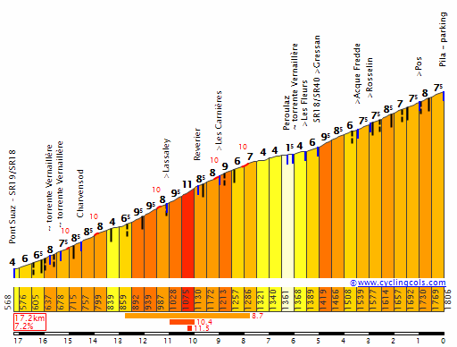
These average a little over 7% so with this and Lin Noir back to back, riders will have to be wary about letting strong escapes go, as well as the favourites needing to look after their domestiques. But once they're over the two major climbs, it's all about smaller punchy climbs, so will depend on who's feeling strong out of hilly riders whether they can stay with the strong grimpeurs who will want to leave them behind before the circuit.
Plus with the circuit itself, the toughest climb is the first, so it's furthest from the finish, yet going there does entail a bit of solo action against the chase on the more gradual final climb, and some technical cornering on the run-in. This could be a really intriguing battle.
First, we'll look at the circuit on which these are based.
Aosta Circuit, 18,25km
At just over 18km, this circuit is a little longer than the current vogue at the Worlds, but it includes some serious challenges that make it the hardest one we will have seen since Mendrisio. There are two feed zones, one directly after the start-finish, and one in the middle of the circuit, outside the Università della Valle d'Aosta. There are three climbs on the circuit, two notable and one smaller.
The first is the toughest challenge on the course, a very punchy and tricky climb of just over 2km to the Frazione Pont d'Aisod (typo in profile):
The presences of bridges and tunnels make that profile unreliable in terms of those radical ups and downs, but the overall stats - 2,5km @ 8,6% with the toughest stuff in the middle - is pretty fair. This is around 15km from the end of the circuit. After this there is a short drag of around 700m at 5% before the riders join the SR38; at this length it's unlikely to cause any trouble but it could create a surprise platform for an attack if nobody's moved on the way to Pont d'Aisod. The descent includes some technical corners but is wide enough that it is more reminiscent of the route down from the Col d'Èze in old Paris-Nice loop stages than a Poggio-esque blast. After the feedzone we have the final climb of the circuit, which will be the last climb of the entire race, up to the village of Porossan:
As you can see it's a much easier climb than Pont d'Aisod, mostly consistent but with that last 300m ramping up towards 12%. The final time we pass this is 6,6km from the line. There's a little false flat to the true highest point between Porossan and the neighbouring village of Senin. After this it's a single tight, tricky hairpin before a very fast and straight descent to the outskirts of town, where a series of technical corners around roundabouts take us past Arco Augusto and into Viale Torino, as close as we get to the old town in Aosta as we pass some remnants of the Roman walls before a left onto a short stretch (150-200m) of city centre cobbles leading to the railway station, where after a couple of fairly wide open corners we hit the final 600m straight.
As you can see, a circuit where nearly a third is spent climbing and including some mighty tough gradients, so this will get very selective.
Road Race: Junior Women
Aosta - Aosta, 92km
The Junior Women are the only ones to start and finish in Aosta; their race consists of 5 laps of the circuit only. Which, ironically, is more than the elite women do.
Road Race: Junior Men
Châtillon-Saint-Vincent - Aosta, 141km
The Junior men start in Châtillon-Saint-Vincent for a flat first 30km run-in and then do 6 laps of the Aosta circuit.
Road Race: U23 Men
Pont-Saint-Martin - Aosta, 183km
The espoirs are the first to really see the nasty side of this course, as they start in Pont-Saint-Martin and continue on with the longer run-in to the centre than the Juniors, however rather than riding to the finish line they take the same detour south of the Dora Baltea that the elite men did in their time trial, that takes us through Pila to Aymavilles and then across to Sarre. From there, we have one serious climb to precede the circuit, that being Lin-Noir, which also featured as the final climb in my Giro Rosa.
As you can see, the stats don't tell it all as the first 6km are at over 9%. The objective here is that we accept that on the hilly circuit that there will be a variety of riders able to assist but we want to prevent the problem that the Ardennes Classics have, which is that many helpers stay there until late on meaning tame racing. If we use a more serious climb than the Ardennes have available to them to burn these off, then even if they chase back on they have to expend a lot of energy to do so, so that they will be more vulnerable to moves later on. After that, the descent from Lin-Noir is on the SR38 that takes us down to the feed station at the University, so we then do Porossan before five full laps of the circuit.
Road Race: Elite Women
Châtillon-Saint-Vincent - Aosta, 143km
The Women's road race follows the same concept, utilizing Lin-Noir to narrow down the field of contenders before hitting the final circuit. It's just that they have a shorter run-in to the big climb, then only four and a half laps instead of five and a half. This would probably be the toughest World Championships road race the women have ever had, but they showed in Rio that they're more than capable of putting on a great spectacle in those tougher courses. Also, it means seeing a course where many of the usual suspects - Vos, Deignan, Johansson (albeit now retiring) are actually on the back foot in terms of surviving it out to compete for the win.
Road Race: Elite Men
Pont-Saint-Martin - Aosta, 259km
Although 259km is not all that long for a Worlds, we do have here one of the toughest routes there's ever been. We follow the same concept as is common in recent years of approximately 100km before laps of a circuit, however not only is that circuit tough but here the lead-in is brutal too. Much like the U23 men and Elite Women, the men have to take on Lin-Noir before they join the circuit, however as the increased number of circuits pushes this further from the finish, in order to have the same intended effect there needs to be more toughness, hence before it I have also added the climb to Les Fleurs, which is a very nasty climb to the point where the two routes to the Pila ski station converge, corresponding to the first 12,2km of this:
These average a little over 7% so with this and Lin Noir back to back, riders will have to be wary about letting strong escapes go, as well as the favourites needing to look after their domestiques. But once they're over the two major climbs, it's all about smaller punchy climbs, so will depend on who's feeling strong out of hilly riders whether they can stay with the strong grimpeurs who will want to leave them behind before the circuit.
Plus with the circuit itself, the toughest climb is the first, so it's furthest from the finish, yet going there does entail a bit of solo action against the chase on the more gradual final climb, and some technical cornering on the run-in. This could be a really intriguing battle.
Paris-Nice
Stage 6: Carpentras - Draguignan (185km)
http://www.la-flamme-rouge.eu/maps/viewtrack/hd/79192

After three consecutive GC stages, it's finally a rest for the riders who should be fighting in that and a day for others. The start is in Carpentras and the riders head south-east. The first intermediate sprint is in Pertuis, and the second in Draguignan, during the first passage of the finish line, with 18.5km to go. Then there is one loop around the city, which includes the Col de la Grange, cresting with 10.2km to go. This will be a day for the attackers, who may try and find an opportunity on the climb, or breakaway specialists, who may try and hold ahead of the peloton and make use of the climb. Either way, it's unlikely to be a day for the sprinters.
Start
Carpentras, Cours de la Pyramide (km0 is on the D938, within the city borders)
Finish
Draguignan, Boulevard Marechal Foch, after a 18.5km circuit
Climbs
Col de la Grange (3.7 Km at 5.1%, cat. 2)
Sprints
Pertuis
Draguignan
The next stage
The final mountainus stage, ending at our destination.
Stage 6: Carpentras - Draguignan (185km)
http://www.la-flamme-rouge.eu/maps/viewtrack/hd/79192
After three consecutive GC stages, it's finally a rest for the riders who should be fighting in that and a day for others. The start is in Carpentras and the riders head south-east. The first intermediate sprint is in Pertuis, and the second in Draguignan, during the first passage of the finish line, with 18.5km to go. Then there is one loop around the city, which includes the Col de la Grange, cresting with 10.2km to go. This will be a day for the attackers, who may try and find an opportunity on the climb, or breakaway specialists, who may try and hold ahead of the peloton and make use of the climb. Either way, it's unlikely to be a day for the sprinters.
Start
Carpentras, Cours de la Pyramide (km0 is on the D938, within the city borders)
Finish
Draguignan, Boulevard Marechal Foch, after a 18.5km circuit
Climbs
Col de la Grange (3.7 Km at 5.1%, cat. 2)
Sprints
Pertuis
Draguignan
The next stage
The final mountainus stage, ending at our destination.
TRENDING THREADS
-
 Paris-Roubaix 2026, one day monument, April 12
- Started by Lequack
- Replies: 2K
-
 Itzulia Basque Country 2026, April 6-11
- Started by Dazed and Confused
- Replies: 2K
-
 Ronde van Vlaanderen 2026, monument, April 5 (men's)
- Started by Krzysztof_O
- Replies: 1K
-

-

-

-
 Teams & Riders The Remco Evenepoel is the next Eddy Merckx thread
- Started by DNP-Old
- Replies: 39K
Cyclingnews is part of Future plc, an international media group and leading digital publisher. Visit our corporate site.
© Future Publishing Limited Quay House, The Ambury, Bath BA1 1UA. All rights reserved. England and Wales company registration number 2008885.