
Race Design Thread
Page 263 - Get up to date with the latest news, scores & standings from the Cycling News Community.
You are using an out of date browser. It may not display this or other websites correctly.
You should upgrade or use an alternative browser.
You should upgrade or use an alternative browser.
- Apr 15, 2016
- 4,250
- 680
- 17,680
Re:
")
Giro d' Italia Stage 9 Perugia-Montalcino 177.4 km Hilly/Medium Mountain
https://www.la-flamme-rouge.eu/maps/viewtrack/hd/120428
KOM SPRINTS:
Vivo d'Orcia (2nd Category, 927 m, 10.9 Km at 5.4%, Km 91.0)
Monte Amiata (1st Category, 1593 m, 15.9 Km at 6.2%, Km 121.0)
Sant' Angelo in Colle (3rd Category, 421 m, 4.9 Km at 6.3%, Km 159.1)
Ragnaie (3rd Category, 641 m, 5.6 Km at 5.8%, Km 173.7)
STERRATO SECTORS:
1. Sant' Angelo (5600 m, Km 158.5)
2. Sesta (6800 m, Km 166.6)
3. Ragnaie (5700 m, Km 173.8)
The first intermediate sprint of the day is at Chiusi. Then the things get a bit serious with the 2nd category climb of Vivo d'Orcia which is 10.9 km at %5,4.
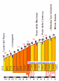
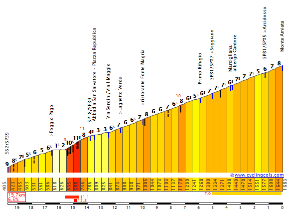
With a bit more than 70 km to go the main climb of the day, Monte Amiata starts. 15,9 km at %6,2 but since there is a descent part the stats don't tell the complete truth.
Monte Amiata: ( The climb is 2 parts (there is a descent between 2 parts), part 1 is photo 1 (to Prato della Contessa) , part 2 is photo 2 (from Seggiano intersection to the Arcidosso intersection) )
After the end of the steeper part of the descent there is the 2nd and last intermediate sprint of the day in Arcidosso.
With less than 25 kms to go, things get much more serious. The first sterrato sector of the stage, Sant' Angelo, 5.6 km. Also most of the starrato are climbing. The sector ends with 18.9 km to go and 600m after the end of the sterrato sector the climb ends as well, which is named as Sant' Angelo in Colle, 4.9 km at %6,3.
Only 700m after the top of the climb, our 2nd starrto sector begins, named Sesta which is 6.8 km.
When the sector ends there is a 1.5 km of asphalt before the 3rd and final sterrato sector of the day, Ragnaie. And this sterrato is mostly climbing as well and the climb, which is 3rd category with 5.6 km at %5.8, ends with 3.7 km to go while the sterrato ends just 100m after the climb.
The final part is flat and descend into the town of Montalcino, which was the stage finish of 2010 Giro d' Italia Stage 7, the stage which included sterrato and some climbing. And it was an excellent stage (it was won by Cadel Evans, while Vino took the maglia rosa from Nibali who had to shepherd Basso to the line.)
Photos from the sterrato sectors:
Sant' Angelo:
https://www.google.com/maps/@42.9670487,11.4433245,3a,61.8y,270.77h,89.89t/data=!3m6!1e1!3m4!1sSynOCxmDYdKk8nzKXk5gug!2e0!7i13312!8i6656
https://www.google.com/maps/@42.9771789,11.4516308,3a,61.8y,19.87h,101.83t/data=!3m6!1e1!3m4!1snhaozlc-4dQzEJMjURLXBg!2e0!7i13312!8i6656
https://www.google.com/maps/@42.9869829,11.4582685,3a,61.8y,356.11h,98.2t/data=!3m6!1e1!3m4!1snCEX-FidylJ6O0ro8c511w!2e0!7i13312!8i6656
https://www.google.com/maps/@42.9929605,11.4591121,3a,61.8y,151.79h,98.49t/data=!3m6!1e1!3m4!1sfHHrpkNGc-fz2OM9zom6_g!2e0!7i13312!8i6656
https://www.google.com/maps/@42.9956185,11.4599966,3a,61.8y,79.73h,100.75t/data=!3m6!1e1!3m4!1sW4eUx6fObvBJ1fxwjdx-EQ!2e0!7i13312!8i6656
Sesta:
https://www.google.com/maps/@43.0046339,11.4660741,3a,61.8y,271.72h,82.09t/data=!3m6!1e1!3m4!1sddg3r2BZ-JuDZmiAZ8XO9g!2e0!7i13312!8i6656
https://www.google.com/maps/@43.003207,11.4718396,3a,61.8y,95.2h,87.46t/data=!3m6!1e1!3m4!1scDpSoO9PEq3TSC0eaWDvng!2e0!7i13312!8i6656
https://www.google.com/maps/@43.000106,11.474958,3a,61.8y,49.94h,93.28t/data=!3m6!1e1!3m4!1sW7d3wQpeQQnxzzIIapeeIA!2e0!7i13312!8i6656
https://www.google.com/maps/@42.9936948,11.4798846,3a,61.8y,280.78h,92.57t/data=!3m6!1e1!3m4!1sqcGqBfce4dXKmRITpNfwow!2e0!7i13312!8i6656
https://www.google.com/maps/@42.9914258,11.4917971,3a,61.8y,271.71h,58.3t/data=!3m6!1e1!3m4!1sF_6TJ65dwChdXxGvg6ufzA!2e0!7i13312!8i6656
https://www.google.com/maps/@42.990221,11.5059762,3a,61.8y,120.76h,87.14t/data=!3m6!1e1!3m4!1sNDUDw9NQsZq33lcM7RToCQ!2e0!7i13312!8i6656
https://www.google.com/maps/@42.994581,11.5136905,3a,61.8y,333.42h,75.25t/data=!3m6!1e1!3m4!1sHWVGQNJVi12kQvTdiWnuJA!2e0!7i13312!8i6656
Ragnaie:
https://www.google.com/maps/@43.0187704,11.4997017,3a,61.8y,321.82h,95.79t/data=!3m6!1e1!3m4!1s5e4ztV4K2wSMHc_sV5gicA!2e0!7i13312!8i6656
https://www.google.com/maps/@43.023472,11.4974628,3a,61.8y,187.9h,87.64t/data=!3m6!1e1!3m4!1sSzBZtU_ozKjesbxib6aQwA!2e0!7i13312!8i6656
https://www.google.com/maps/@43.0293725,11.4926628,3a,61.8y,336.93h,95.75t/data=!3m6!1e1!3m4!1sineNANObSoUEjWCzalIKXA!2e0!7i13312!8i6656
https://www.google.com/maps/@43.0326447,11.484718,3a,61.8y,117.49h,92.58t/data=!3m6!1e1!3m4!1s2pLAHB5aEVdYEMgqbeSyhQ!2e0!7i13312!8i6656
https://www.google.com/maps/@43.0341161,11.481902,3a,61.8y,263.94h,94.98t/data=!3m6!1e1!3m4!1srsc_FVTHNzIBbAqecLWttg!2e0!7i13312!8i6656
Perugia:
Montalcino:
PS: Ignore the difficulty of the sterrato sectors there, since I don't know about their difficulties I just said the difficulty is 1 since there wasn't an option that disregards the difficulty of the sectors.
Ah, understood now.bp92 said:Oops, I meant to say the Giro I've been working in compared to the one I posted a while ago.
Sorry for the confusion :redface:
Giro d' Italia Stage 9 Perugia-Montalcino 177.4 km Hilly/Medium Mountain
https://www.la-flamme-rouge.eu/maps/viewtrack/hd/120428
KOM SPRINTS:
Vivo d'Orcia (2nd Category, 927 m, 10.9 Km at 5.4%, Km 91.0)
Monte Amiata (1st Category, 1593 m, 15.9 Km at 6.2%, Km 121.0)
Sant' Angelo in Colle (3rd Category, 421 m, 4.9 Km at 6.3%, Km 159.1)
Ragnaie (3rd Category, 641 m, 5.6 Km at 5.8%, Km 173.7)
STERRATO SECTORS:
1. Sant' Angelo (5600 m, Km 158.5)
2. Sesta (6800 m, Km 166.6)
3. Ragnaie (5700 m, Km 173.8)
The first intermediate sprint of the day is at Chiusi. Then the things get a bit serious with the 2nd category climb of Vivo d'Orcia which is 10.9 km at %5,4.
With a bit more than 70 km to go the main climb of the day, Monte Amiata starts. 15,9 km at %6,2 but since there is a descent part the stats don't tell the complete truth.
Monte Amiata: ( The climb is 2 parts (there is a descent between 2 parts), part 1 is photo 1 (to Prato della Contessa) , part 2 is photo 2 (from Seggiano intersection to the Arcidosso intersection) )
After the end of the steeper part of the descent there is the 2nd and last intermediate sprint of the day in Arcidosso.
With less than 25 kms to go, things get much more serious. The first sterrato sector of the stage, Sant' Angelo, 5.6 km. Also most of the starrato are climbing. The sector ends with 18.9 km to go and 600m after the end of the sterrato sector the climb ends as well, which is named as Sant' Angelo in Colle, 4.9 km at %6,3.
Only 700m after the top of the climb, our 2nd starrto sector begins, named Sesta which is 6.8 km.
When the sector ends there is a 1.5 km of asphalt before the 3rd and final sterrato sector of the day, Ragnaie. And this sterrato is mostly climbing as well and the climb, which is 3rd category with 5.6 km at %5.8, ends with 3.7 km to go while the sterrato ends just 100m after the climb.
The final part is flat and descend into the town of Montalcino, which was the stage finish of 2010 Giro d' Italia Stage 7, the stage which included sterrato and some climbing. And it was an excellent stage (it was won by Cadel Evans, while Vino took the maglia rosa from Nibali who had to shepherd Basso to the line.)
Photos from the sterrato sectors:
Sant' Angelo:
https://www.google.com/maps/@42.9670487,11.4433245,3a,61.8y,270.77h,89.89t/data=!3m6!1e1!3m4!1sSynOCxmDYdKk8nzKXk5gug!2e0!7i13312!8i6656
https://www.google.com/maps/@42.9771789,11.4516308,3a,61.8y,19.87h,101.83t/data=!3m6!1e1!3m4!1snhaozlc-4dQzEJMjURLXBg!2e0!7i13312!8i6656
https://www.google.com/maps/@42.9869829,11.4582685,3a,61.8y,356.11h,98.2t/data=!3m6!1e1!3m4!1snCEX-FidylJ6O0ro8c511w!2e0!7i13312!8i6656
https://www.google.com/maps/@42.9929605,11.4591121,3a,61.8y,151.79h,98.49t/data=!3m6!1e1!3m4!1sfHHrpkNGc-fz2OM9zom6_g!2e0!7i13312!8i6656
https://www.google.com/maps/@42.9956185,11.4599966,3a,61.8y,79.73h,100.75t/data=!3m6!1e1!3m4!1sW4eUx6fObvBJ1fxwjdx-EQ!2e0!7i13312!8i6656
Sesta:
https://www.google.com/maps/@43.0046339,11.4660741,3a,61.8y,271.72h,82.09t/data=!3m6!1e1!3m4!1sddg3r2BZ-JuDZmiAZ8XO9g!2e0!7i13312!8i6656
https://www.google.com/maps/@43.003207,11.4718396,3a,61.8y,95.2h,87.46t/data=!3m6!1e1!3m4!1scDpSoO9PEq3TSC0eaWDvng!2e0!7i13312!8i6656
https://www.google.com/maps/@43.000106,11.474958,3a,61.8y,49.94h,93.28t/data=!3m6!1e1!3m4!1sW7d3wQpeQQnxzzIIapeeIA!2e0!7i13312!8i6656
https://www.google.com/maps/@42.9936948,11.4798846,3a,61.8y,280.78h,92.57t/data=!3m6!1e1!3m4!1sqcGqBfce4dXKmRITpNfwow!2e0!7i13312!8i6656
https://www.google.com/maps/@42.9914258,11.4917971,3a,61.8y,271.71h,58.3t/data=!3m6!1e1!3m4!1sF_6TJ65dwChdXxGvg6ufzA!2e0!7i13312!8i6656
https://www.google.com/maps/@42.990221,11.5059762,3a,61.8y,120.76h,87.14t/data=!3m6!1e1!3m4!1sNDUDw9NQsZq33lcM7RToCQ!2e0!7i13312!8i6656
https://www.google.com/maps/@42.994581,11.5136905,3a,61.8y,333.42h,75.25t/data=!3m6!1e1!3m4!1sHWVGQNJVi12kQvTdiWnuJA!2e0!7i13312!8i6656
Ragnaie:
https://www.google.com/maps/@43.0187704,11.4997017,3a,61.8y,321.82h,95.79t/data=!3m6!1e1!3m4!1s5e4ztV4K2wSMHc_sV5gicA!2e0!7i13312!8i6656
https://www.google.com/maps/@43.023472,11.4974628,3a,61.8y,187.9h,87.64t/data=!3m6!1e1!3m4!1sSzBZtU_ozKjesbxib6aQwA!2e0!7i13312!8i6656
https://www.google.com/maps/@43.0293725,11.4926628,3a,61.8y,336.93h,95.75t/data=!3m6!1e1!3m4!1sineNANObSoUEjWCzalIKXA!2e0!7i13312!8i6656
https://www.google.com/maps/@43.0326447,11.484718,3a,61.8y,117.49h,92.58t/data=!3m6!1e1!3m4!1s2pLAHB5aEVdYEMgqbeSyhQ!2e0!7i13312!8i6656
https://www.google.com/maps/@43.0341161,11.481902,3a,61.8y,263.94h,94.98t/data=!3m6!1e1!3m4!1srsc_FVTHNzIBbAqecLWttg!2e0!7i13312!8i6656
Perugia:
Montalcino:
PS: Ignore the difficulty of the sterrato sectors there, since I don't know about their difficulties I just said the difficulty is 1 since there wasn't an option that disregards the difficulty of the sectors.
Giro d'Italia: Stage 12: Avezzano - Ascoli, 225 km
Another long and tough medium mountain stage in the Apennines. The stage starts in Avezzano moving northeast after the start. The top of the first climb, the small village of Ovindoli, is reached after 26 km. The route continues through Rocca di Mezzo and Rocca di Cambio before descending and looping west of L'Aquila on their way northeast.
The next climb to Valico Delle Capannelle starts after 78 km and is followed in rapid succession by the climbs to Crognaleto, Belvedere and Prevenisco. The climbs are not very steep, but the length, the lack of flat sections and the total number of height meters still makes this a very tough stage. After descending from Prevenisco, the riders have reached about 190 km. Here they could have ridden along the main road to the stage finish in Ascoli. But instead there have to climb San Giancomo, used as a MTF in the 2002 Giro, before descending to the stage finish. The descent is pretty tough and could be a possibility for an attack. The length and number of climbs could also make this a thrilling stage for the GC contenders if ridden aggressively.
Climbs:
26 km: Ovindoli: 12,3 km, 5 %
91 km: Valico Delle Capannelle: 13,3 km, 4,7 %
119 km: Crognaleto: 7,4 km, 5,8 %
155 km: Belvedere: 15,7 km, 3,7 %
177 km: Prevenisco: 7,4 km, 5,7 %
208 km: San Giancomo: 9,6 km, 6,8 %
Profile:

Map:

Another long and tough medium mountain stage in the Apennines. The stage starts in Avezzano moving northeast after the start. The top of the first climb, the small village of Ovindoli, is reached after 26 km. The route continues through Rocca di Mezzo and Rocca di Cambio before descending and looping west of L'Aquila on their way northeast.
The next climb to Valico Delle Capannelle starts after 78 km and is followed in rapid succession by the climbs to Crognaleto, Belvedere and Prevenisco. The climbs are not very steep, but the length, the lack of flat sections and the total number of height meters still makes this a very tough stage. After descending from Prevenisco, the riders have reached about 190 km. Here they could have ridden along the main road to the stage finish in Ascoli. But instead there have to climb San Giancomo, used as a MTF in the 2002 Giro, before descending to the stage finish. The descent is pretty tough and could be a possibility for an attack. The length and number of climbs could also make this a thrilling stage for the GC contenders if ridden aggressively.
Climbs:
26 km: Ovindoli: 12,3 km, 5 %
91 km: Valico Delle Capannelle: 13,3 km, 4,7 %
119 km: Crognaleto: 7,4 km, 5,8 %
155 km: Belvedere: 15,7 km, 3,7 %
177 km: Prevenisco: 7,4 km, 5,7 %
208 km: San Giancomo: 9,6 km, 6,8 %
Profile:
Map:
Giro d'Italia: Stage 13: Ascoli - Fano, 200 km
Finally, some well-deserved "rest" for the GC contenders. This is one of the easiest stages of this Giro, and a typical transfer stage along the Adriatic coast. The stage starts in Ascoli and heads directly east towards the coast which is reached after about 25 km. Most of the rest of the stage is ridden along the coast line except a detour between 80 and 140 km looping around Macerata and somewhat more hilly terrain, although there are no categorized climbs. The coast is yet again reached by Ancona, and the last 60 km to the stage finish in Fano is flat.
Profile:

Map:

Finally, some well-deserved "rest" for the GC contenders. This is one of the easiest stages of this Giro, and a typical transfer stage along the Adriatic coast. The stage starts in Ascoli and heads directly east towards the coast which is reached after about 25 km. Most of the rest of the stage is ridden along the coast line except a detour between 80 and 140 km looping around Macerata and somewhat more hilly terrain, although there are no categorized climbs. The coast is yet again reached by Ancona, and the last 60 km to the stage finish in Fano is flat.
Profile:
Map:
- Aug 3, 2015
- 22,826
- 10,850
- 28,180
Have anyone tried to create a Giro without using the Alps? Should be more than doable, its a shame they went along such flat roads to reach the last week this year.
Makes you wonder why the geniuses haven't used it recently (or ever?)... the more you know.Libertine Seguros said:2013 Giro Donne stage 5: Varazze - Monte Beigua (part 1 of 4)Valv.Piti said:That looks like an absolute perfect first MTF in the Giro, chapeau. Never heard of that one. Seems very similar to Passo Lanciano when they climbed it in 2006. Belgua and Blockhaus to the top, a long ITT and some strade bianche before the penultimate weekend and we set.
With Pooley not racing, there's nobody to challenge Abbott who puts on an exhibition to underpin her second overall victory; Vos explodes and loses 5 minutes; 39-year-old former superstar Fabiana Luperini has her last hurrah as a mountain climber before being DQed for an underweight bike, while a 20-year-old Francesca Cauz climbs like a beast and shows the kind of form that she's struggled to recapture since, as she is the female Igor Antón.
Giro d'Italia: Stage 14: Pesaro - San Marino, 214 km
Last hilly stage in the Apennines, and we end with a bang! The stage is set in the very hilly terrain in Emilia Romagna which is sometimes used, but rarely taken fully advantage of in the Giro. This is an attempt to correct this. The stage starts in Pesaro by the Adriatic Sea and heads west. The first 50 km is mostly flat before the first climb to Sassocorvaro. This is shortly followed by another, uncategorized climb before another flat section.
This changes after turning off the main road at Borgio Pace after 83 km. From this point there is very few flat sections and it's almost entirely up and down the rest of the stage. After passing Borgio Pace and starting the climb to Passo della Spugna, the route zig-zags through the hilly terrain northeast towards the republic of San Marino.
A total of 7 categorized (and one uncategorized) climbs for the last 130 km of the stage. The most well-known is probably Monte Carpegna which has been used in the Giro several times. This time they are not climbing the to the top of the mountain, but just looping around it. After Carpegna it's still 70 kms and 4 climbs to go. The last is the 8 km, 5,4 % climb to the stage finish in the small republic in San Marino.
Climbs:
52 km: Sassocorvaro: 5,2 km, 5,9 %
88 km: Passo della Spugna: 4,7 km, 6,2 %
102 km: Valico San Cristoforo: 5,6 km, 7,2 %
124 km: Miratolo: 6,2 km, 5,9 %
145 km: Monte Carpegna: 7,7 km, 6,4 %
183 km: Colle San Leo: 8,3 km, 5,4 %
196 km: Montemaggio: 4,3 km, 6,2 %
214 km: San Marino: 8,6 km, 5,4 %
Profile:

Map:

Last hilly stage in the Apennines, and we end with a bang! The stage is set in the very hilly terrain in Emilia Romagna which is sometimes used, but rarely taken fully advantage of in the Giro. This is an attempt to correct this. The stage starts in Pesaro by the Adriatic Sea and heads west. The first 50 km is mostly flat before the first climb to Sassocorvaro. This is shortly followed by another, uncategorized climb before another flat section.
This changes after turning off the main road at Borgio Pace after 83 km. From this point there is very few flat sections and it's almost entirely up and down the rest of the stage. After passing Borgio Pace and starting the climb to Passo della Spugna, the route zig-zags through the hilly terrain northeast towards the republic of San Marino.
A total of 7 categorized (and one uncategorized) climbs for the last 130 km of the stage. The most well-known is probably Monte Carpegna which has been used in the Giro several times. This time they are not climbing the to the top of the mountain, but just looping around it. After Carpegna it's still 70 kms and 4 climbs to go. The last is the 8 km, 5,4 % climb to the stage finish in the small republic in San Marino.
Climbs:
52 km: Sassocorvaro: 5,2 km, 5,9 %
88 km: Passo della Spugna: 4,7 km, 6,2 %
102 km: Valico San Cristoforo: 5,6 km, 7,2 %
124 km: Miratolo: 6,2 km, 5,9 %
145 km: Monte Carpegna: 7,7 km, 6,4 %
183 km: Colle San Leo: 8,3 km, 5,4 %
196 km: Montemaggio: 4,3 km, 6,2 %
214 km: San Marino: 8,6 km, 5,4 %
Profile:
Map:
Re:
I have created a version without using the Dolomites. I think there were 3 stages in the Alps in that version; a MTF to Monviso, a Aosta stage with MTF in Pila and a descent finish in Stresa after Mottarone.
But I'm actually thinking of modifying this to a version also without the Alps. Will probably post this later this summer.
Have anyone tried to create a Giro without using the Alps? Should be more than doable, its a shame they went along such flat roads to reach the last week this year.
I have created a version without using the Dolomites. I think there were 3 stages in the Alps in that version; a MTF to Monviso, a Aosta stage with MTF in Pila and a descent finish in Stresa after Mottarone.
But I'm actually thinking of modifying this to a version also without the Alps. Will probably post this later this summer.
Giro d'Italia: Stage 15: Padova - Padova, 60 km ITT
The race have moved into the southern part of Veneto, to Padova, where the second and last ITT of this Giro is ridden. Both start and finish in Padova and the route is south of the city. The first 15 and the last 22-23 km is flat but in the middle there is a hilly section where the riders will have to climb around Monte Venda. A first climb of 2 km and 100 height meters is followed by a climb of 3 km and 200 height meters and lastly 1,5 km and 100 height meters close to the top of Monte Rua. A 5 km descent follows before the last 22 km flat section to the stage finish. Although there are some difficulties height difference on the TT, this will probably be a chance for the best time trialists of the GC contenders to gain some time on the more typical climbers.
Profile:

Map:

The race have moved into the southern part of Veneto, to Padova, where the second and last ITT of this Giro is ridden. Both start and finish in Padova and the route is south of the city. The first 15 and the last 22-23 km is flat but in the middle there is a hilly section where the riders will have to climb around Monte Venda. A first climb of 2 km and 100 height meters is followed by a climb of 3 km and 200 height meters and lastly 1,5 km and 100 height meters close to the top of Monte Rua. A 5 km descent follows before the last 22 km flat section to the stage finish. Although there are some difficulties height difference on the TT, this will probably be a chance for the best time trialists of the GC contenders to gain some time on the more typical climbers.
Profile:
Map:
- Feb 18, 2015
- 13,913
- 10,041
- 28,180
@Forever the Best
I really like your sterrato stage. Great idea to use a hard 1st category climb early on and hilly gravel roads afterwards. That should give riders the opportunity to make the race hard early on to make the sterrato sections even harder.
I really like your sterrato stage. Great idea to use a hard 1st category climb early on and hilly gravel roads afterwards. That should give riders the opportunity to make the race hard early on to make the sterrato sections even harder.
- Apr 15, 2016
- 4,250
- 680
- 17,680
Thanks a lot for the comment! That's what I had in my mind when designing the stage!Gigs_98 said:@Forever the Best
I really like your sterrato stage. Great idea to use a hard 1st category climb early on and hilly gravel roads afterwards. That should give riders the opportunity to make the race hard early on to make the sterrato sections even harder.
- Apr 15, 2016
- 4,250
- 680
- 17,680
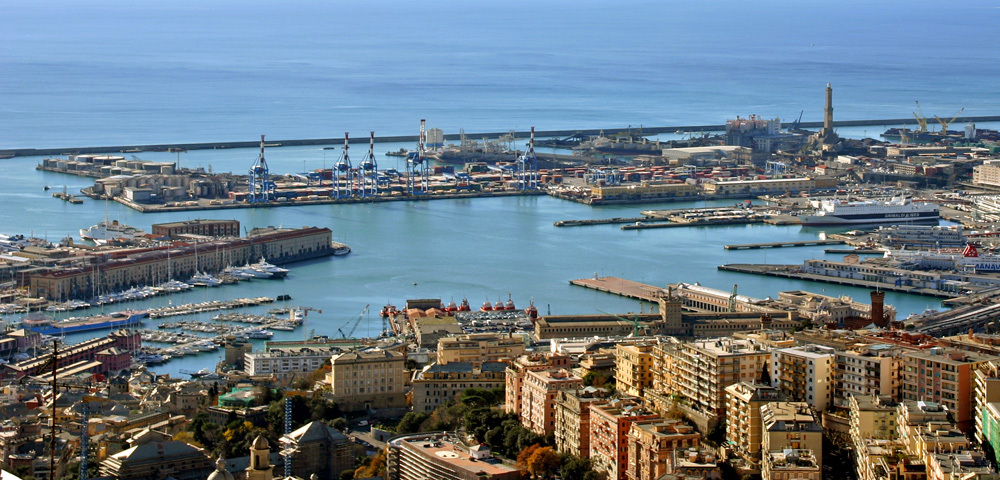
Giro d'Italia Stage 10 Genova-La Spezia 162,5 km Flat
https://www.la-flamme-rouge.eu/maps/viewtrack/hd/120447
KOM SPRINTS:
San Martino di Noceto (3rd Category, 285 m, 4.4 Km at 6.4%, Km 24.5)
Santuario di Velva (3rd Category, 548 m, 13.5 Km at 3.8%, Km 78.1)
After the rest day, a flat stage from Genova to La Spezia. The stage is mostly flat, except 2 3rd categorized climbs. Intermediate sprints are in Chiavari and Sestri Levante. There should be a mass-sprint in La Spezia.
Genova:
Chiavari:
Sestri Levante:

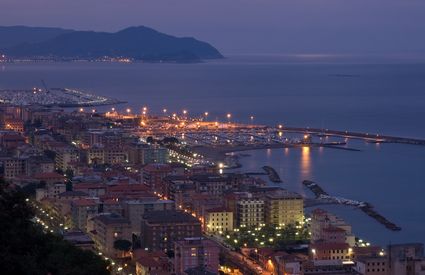
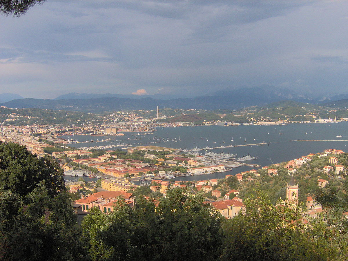
La Spezia:
https://www.la-flamme-rouge.eu/maps/viewtrack/hd/120447
KOM SPRINTS:
San Martino di Noceto (3rd Category, 285 m, 4.4 Km at 6.4%, Km 24.5)
Santuario di Velva (3rd Category, 548 m, 13.5 Km at 3.8%, Km 78.1)
After the rest day, a flat stage from Genova to La Spezia. The stage is mostly flat, except 2 3rd categorized climbs. Intermediate sprints are in Chiavari and Sestri Levante. There should be a mass-sprint in La Spezia.
Genova:
Chiavari:
Sestri Levante:
La Spezia:
- Oct 4, 2015
- 417
- 1
- 3,030
Beautiful stage to San Marino. That Carpegna/San Marino area is criminally underused for the massive potential for medium mountain stages there (and Monte Carpegna's own story as Marco Pantani's favourite training climb).
They went to Carpegna in 2013, but it's been a while since they went to San Marino (I think?).
The sterrato stage's also pretty unique. Hopefully it rains :twisted: .
They went to Carpegna in 2013, but it's been a while since they went to San Marino (I think?).
The sterrato stage's also pretty unique. Hopefully it rains :twisted: .
- Oct 4, 2015
- 417
- 1
- 3,030
Might as well gest started with my own Vuelta a Colombia, now that we're at it.
Vuelta a Colombia Stage 1: Mocoa - Mocoa, 4,3km (ITT)


Climbs: none.
Typically the Vuelta a Colombia starts off either in northern Colombia or over the Andes. This time I decided to start off south of the mountain chain instead, in the town of Mocoa. The town was hit by a devastating mudslide in April so this stage's goal would be to commemorate the disaster and to (hopefully) bring some tourism to the area as well. The stage itself is nothing special; a short, mostly flat prologue in the city's streets, starting and finishing in the town square. First leader's jersey should go to a time trial specialist, even though it's not very likely they'll hold on to it for long...
Vuelta a Colombia Stage 1: Mocoa - Mocoa, 4,3km (ITT)
Climbs: none.
Typically the Vuelta a Colombia starts off either in northern Colombia or over the Andes. This time I decided to start off south of the mountain chain instead, in the town of Mocoa. The town was hit by a devastating mudslide in April so this stage's goal would be to commemorate the disaster and to (hopefully) bring some tourism to the area as well. The stage itself is nothing special; a short, mostly flat prologue in the city's streets, starting and finishing in the town square. First leader's jersey should go to a time trial specialist, even though it's not very likely they'll hold on to it for long...
- Oct 4, 2015
- 417
- 1
- 3,030
(Note: Some climbs were named after nearby features, since I couldn't find their actual names anywhere.)
Vuelta a Colombia Stage 2: Mocoa - San Agustín, 154km


Climbs: Yunguillo (cat.3), Villalobos (cat.2), El Cable (cat.2), San Agustín (cat.2).
The second stage takes us through the southern edge of the Cordillera Oriental, and ends with the first (pseudo) summit finnish of the race, in the town of San Agustín, best known for its archeological site, which contains the largest group of religious monuments in South America, and is considered an UNESCO World Heritage Site.
The stage itself contains a very hilly first half, with three categorized climbs: the very irregular Yunguillo, the more constant and much steeper Villalobos, and the neverending false flat-like grind to El Cable. After the latter climb there's a long descent which gradualy tappers off into a flat section, interrupted abruptly by the short final climb, which ends less than 1km before the finish line in San Agustín. Stage chasers will look to set up a breakaway in the early climbs, then try to keep the lead until the end. Good puncheurs will want to contest the finish too, which would give them an early run as race leaders, while GC contenders will try not to get caught out in the ensuing mayhem, or even try to steal a couple seconds off their opponents if they can.
Vuelta a Colombia Stage 2: Mocoa - San Agustín, 154km
Climbs: Yunguillo (cat.3), Villalobos (cat.2), El Cable (cat.2), San Agustín (cat.2).
The second stage takes us through the southern edge of the Cordillera Oriental, and ends with the first (pseudo) summit finnish of the race, in the town of San Agustín, best known for its archeological site, which contains the largest group of religious monuments in South America, and is considered an UNESCO World Heritage Site.
The stage itself contains a very hilly first half, with three categorized climbs: the very irregular Yunguillo, the more constant and much steeper Villalobos, and the neverending false flat-like grind to El Cable. After the latter climb there's a long descent which gradualy tappers off into a flat section, interrupted abruptly by the short final climb, which ends less than 1km before the finish line in San Agustín. Stage chasers will look to set up a breakaway in the early climbs, then try to keep the lead until the end. Good puncheurs will want to contest the finish too, which would give them an early run as race leaders, while GC contenders will try not to get caught out in the ensuing mayhem, or even try to steal a couple seconds off their opponents if they can.
- Oct 4, 2015
- 417
- 1
- 3,030
Vuelta a Colombia Stage 3: Pitalito - Neiva, 188km


Climbs: Altamira (cat. 4)
Stage 3 features the first flat sprint of the race. Starting from Pitalito, riders go through very hilly terrain early in the stage, with only one categorized climb, before entering flatter terrain for the final 80km of the stage. A decent breakaway may form in the early hills, but sprint teams should take over the finish in Neiva. They won't have many chances to win, so they'll want to take this one. The oppressive heat of the Magdalena valley may be an important factor, too, further draining the rider's strength.
- Jun 30, 2014
- 7,060
- 2
- 0
I've designed a 2nd version of the Tour of Colorado/USA pro challenge. I'll start posting the fist stages today.
- Jun 30, 2014
- 7,060
- 2
- 0
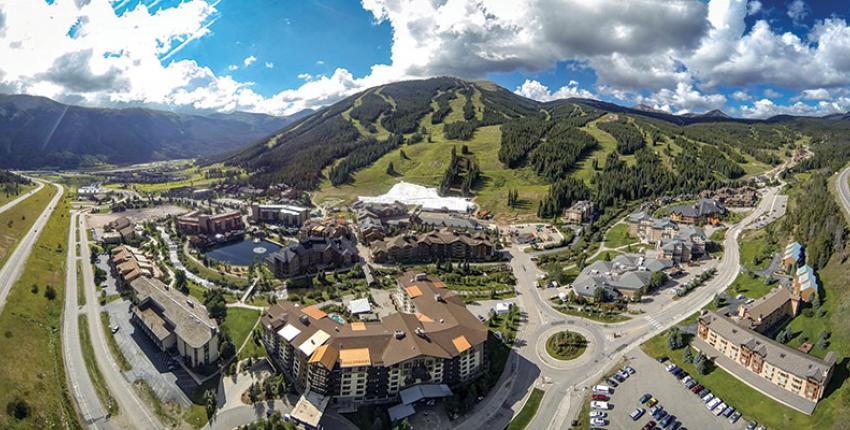
Tour of Colorado stage 1: Aspen - Copper Mountain; 131.6km


The first stage of my Tour of Colorado is pretty short, but not that easy.
The stage starts in the well known Skiing town Aspen, and after just 6km the long Independence Pass already starts, over 25km at nearly 5%, with the clim finishing almost 3700m above sea level, that's not an easy start.

If the breakaway doesn't form on the first 6km, then the riders will have a pretty rough start, it's the first stage, so everyone will still be fresh and it should be a hard fight to enter the breakaway.
The following descent is 26km long and nothing special, after that we have 50km of false flat/rolling terrain before the next climb starts, Fremont Pass. It's only 5.6km at 4.7%, but it could be a nice launching pad for a few strong attacker who want to get the stage win.

On top of the climb you have 7km of false flat, then a really easy American highspeed descent on wide roads will bring the riders all the way down to the Copper Mountain ski resort.
This one could go to the breakaway or to a late attacker, it's the first stage, but I just can't see too many teams that would be willing to organize the chase, the stage it's too hard for the sprinters, takes place at high altiute and despide it's shortness it still features over 2100m of altitude gain and with the next stage featuring over 4000m of altitude gain the gc contenders an their teams will try to save some energy.
Copper Mountain:
The first stage of my Tour of Colorado is pretty short, but not that easy.
The stage starts in the well known Skiing town Aspen, and after just 6km the long Independence Pass already starts, over 25km at nearly 5%, with the clim finishing almost 3700m above sea level, that's not an easy start.
If the breakaway doesn't form on the first 6km, then the riders will have a pretty rough start, it's the first stage, so everyone will still be fresh and it should be a hard fight to enter the breakaway.
The following descent is 26km long and nothing special, after that we have 50km of false flat/rolling terrain before the next climb starts, Fremont Pass. It's only 5.6km at 4.7%, but it could be a nice launching pad for a few strong attacker who want to get the stage win.
On top of the climb you have 7km of false flat, then a really easy American highspeed descent on wide roads will bring the riders all the way down to the Copper Mountain ski resort.
This one could go to the breakaway or to a late attacker, it's the first stage, but I just can't see too many teams that would be willing to organize the chase, the stage it's too hard for the sprinters, takes place at high altiute and despide it's shortness it still features over 2100m of altitude gain and with the next stage featuring over 4000m of altitude gain the gc contenders an their teams will try to save some energy.
Copper Mountain:
- Oct 4, 2015
- 417
- 1
- 3,030
Vuelta a Colombia Stage 4: Neiva - Girardot, 175km


Climbs: None
Stage 4 is one of the easiest stages of the entire race, at least as far as climbing goes. A pan-flat run down the Magdalena valley between Neiva and Girardot, which should finish in a bunch sprint (barring something like a mass crash near the end of the stage). The scorching heat will again be a notable factor, particularly in the first half of the stage, which passes west of the Tatacoa Desert. Temperatures well over 40°C would not be unusual here at all.
- Oct 4, 2015
- 417
- 1
- 3,030
Vuelta a Colombia Stage 6: Melgar - Ibagué, 148km


Climbs: Gualanday (4), Payande (4), Boquerón de Rovira (4), Boquerón de Ibagué (4).
Next comes a short and hilly stage between Melgar and Ibagué, across the Magdalena valley, with four categorized climbs, all of them category 4. The first climb is frequently-used in the Vuelta a Colombia, typically in stages coming from the Bogotá area and finishing in Ibagué. This stage does finish there, but takes a detour through Rovira beforehand, featuring two more categorized climbs. After the detour we return to the main road to Ibagué... then take another detour, climbing the first of the series of climbs that make up the approach to the legendary Alto de la Línea, before turning back towards Ibagué, finishing in a shallow uncategorized climb inside the city. Pure sprinters will probably be knocked out of contention by the final climbs, leaving this stage for puncheurs and hilly classics specialists.
- Apr 15, 2016
- 4,250
- 680
- 17,680
Re:
Also they climbed Carpegna in 2014. Great stage by Olav there as well, 200+ km of riding with several climbs will surely hurt the legs and the gaps can be bigger than expected on San Marino.
Also, bp92, I can't see your Tour of Colombia because Imgur is blocked on my country. (Turkey)
Also interested by what will you do with Colorado, Mayo. It is a shame that the USAPCC uses only a few places for many years.
Thanks a lot for the comment about the to stage! If a GC contender who is good on sterrato is on some deficit after the first stages, his team can shred the peloton on climb and then that rider can attack on sterrato. And if it rain, this one can be a classic like Montalcino.bp92 said:Beautiful stage to San Marino. That Carpegna/San Marino area is criminally underused for the massive potential for medium mountain stages there (and Monte Carpegna's own story as Marco Pantani's favourite training climb).
They went to Carpegna in 2013, but it's been a while since they went to San Marino (I think?).
The sterrato stage's also pretty unique. Hopefully it rains :twisted: .
Also they climbed Carpegna in 2014. Great stage by Olav there as well, 200+ km of riding with several climbs will surely hurt the legs and the gaps can be bigger than expected on San Marino.
Also, bp92, I can't see your Tour of Colombia because Imgur is blocked on my country. (Turkey)
Also interested by what will you do with Colorado, Mayo. It is a shame that the USAPCC uses only a few places for many years.
- Jun 30, 2014
- 7,060
- 2
- 0
Re: Re:
I already created one version of the USAPCC, that time I had a really hard Pikes Peak MTF, so this time I'll try to use other climbs/other sides of the climbs.Forever The Best said:Thanks a lot for the comment about the to stage! If a GC contender who is good on sterrato is on some deficit after the first stages, his team can shred the peloton on climb and then that rider can attack on sterrato. And if it rain, this one can be a classic like Montalcino.bp92 said:Beautiful stage to San Marino. That Carpegna/San Marino area is criminally underused for the massive potential for medium mountain stages there (and Monte Carpegna's own story as Marco Pantani's favourite training climb).
They went to Carpegna in 2013, but it's been a while since they went to San Marino (I think?).
The sterrato stage's also pretty unique. Hopefully it rains :twisted: .
Also they climbed Carpegna in 2014. Great stage by Olav there as well, 200+ km of riding with several climbs will surely hurt the legs and the gaps can be bigger than expected on San Marino.
Also, bp92, I can't see your Tour of Colombia because Imgur is blocked on my country. (Turkey)
Also interested by what will you do with Colorado, Mayo. It is a shame that the USAPCC uses only a few places for many years.
- Apr 15, 2016
- 4,250
- 680
- 17,680
Re: Re:
Just checked it and a very nice race that you've created. Pikes Peak is a brutal climb!Mayomaniac said:I already created one version of the USAPCC, that time I had a really hard Pikes Peak MTF, so this time I'll try to use other climbs/other sides of the climbs.Forever The Best said:Thanks a lot for the comment about the to stage! If a GC contender who is good on sterrato is on some deficit after the first stages, his team can shred the peloton on climb and then that rider can attack on sterrato. And if it rain, this one can be a classic like Montalcino.bp92 said:Beautiful stage to San Marino. That Carpegna/San Marino area is criminally underused for the massive potential for medium mountain stages there (and Monte Carpegna's own story as Marco Pantani's favourite training climb).
They went to Carpegna in 2013, but it's been a while since they went to San Marino (I think?).
The sterrato stage's also pretty unique. Hopefully it rains :twisted: .
Also they climbed Carpegna in 2014. Great stage by Olav there as well, 200+ km of riding with several climbs will surely hurt the legs and the gaps can be bigger than expected on San Marino.
Also, bp92, I can't see your Tour of Colombia because Imgur is blocked on my country. (Turkey)
Also interested by what will you do with Colorado, Mayo. It is a shame that the USAPCC uses only a few places for many years.
- Jun 30, 2014
- 7,060
- 2
- 0
Tour of Colorado stage 2: Silverthorne - Mount Evans; 204.6km


My last version of this race (and my American gt, the Tour of the Mountain States) featured Pikes Peak, so this time we'll have a Mount Evans MTF.
The stage starts in Silverthorne and the first 24km are slightly uphill false flat.
After that the first smaller climb starts, it's the road up to Boreas Pass Rd from Breckenridge, 2km at 7.2%.
The following descent is nothing special, after it we have another 10km of uphillish false flat, then Hoosier Pass starts, 5.7km at 6.1%.
The next 65km are mostly downhill and a bit of rolling terrain, but we're still at high altitude, we're always at least 2600m above sea level.
After that we have the longer and a bit more gentle southern side of Guanella Pass, 16.6km at 5.1%, that's a pretty solid climb.

The following descent is rather long, but not very technical. After that we still have 20m of slightly downhill false flat, then the big climb of the day starts.
It's the well known Mount Evans, 46.6km at 4.2% and the climb finishes 4300m above sea level, that's nasty.
I have to admit that it's not the steepest climb in the world, but the whole stage is pretty hard (almost 4300m of altitude gain) and the altitude could also wear the riders down. Of course it's more of a tempogrinder and it will probably not be the day for really big attacks, but you can loose the race on this day, we'll see tons of riders getting dropped, it will be an elimination race.
Don't worry, the 2nd half of my race will feature a few climbs that are shorter, but steeper.
Mount Evans:


My last version of this race (and my American gt, the Tour of the Mountain States) featured Pikes Peak, so this time we'll have a Mount Evans MTF.
The stage starts in Silverthorne and the first 24km are slightly uphill false flat.
After that the first smaller climb starts, it's the road up to Boreas Pass Rd from Breckenridge, 2km at 7.2%.
The following descent is nothing special, after it we have another 10km of uphillish false flat, then Hoosier Pass starts, 5.7km at 6.1%.
The next 65km are mostly downhill and a bit of rolling terrain, but we're still at high altitude, we're always at least 2600m above sea level.
After that we have the longer and a bit more gentle southern side of Guanella Pass, 16.6km at 5.1%, that's a pretty solid climb.
The following descent is rather long, but not very technical. After that we still have 20m of slightly downhill false flat, then the big climb of the day starts.
It's the well known Mount Evans, 46.6km at 4.2% and the climb finishes 4300m above sea level, that's nasty.
I have to admit that it's not the steepest climb in the world, but the whole stage is pretty hard (almost 4300m of altitude gain) and the altitude could also wear the riders down. Of course it's more of a tempogrinder and it will probably not be the day for really big attacks, but you can loose the race on this day, we'll see tons of riders getting dropped, it will be an elimination race.
Don't worry, the 2nd half of my race will feature a few climbs that are shorter, but steeper.
Mount Evans:
- Apr 15, 2016
- 4,250
- 680
- 17,680
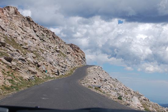
Brutal climb, that Mt.Evans. Also the Pikes Peak reminded me of Ovit Mt. Pass in Rize, a brutal climb, with the last 34 km at %6,4, after the false flat of 34 kms which is %1,5.
http://www.climbbybike.com/climb.asp?Col=Ovit-Climb&qryMountainID=17046
http://www.climbbybike.com/climb.asp?Col=Ovit-Climb&qryMountainID=17046
TRENDING THREADS
-
 Paris-Roubaix 2026, one day monument, April 12
- Started by Lequack
- Replies: 2K
-
 Itzulia Basque Country 2026, April 6-11
- Started by Dazed and Confused
- Replies: 2K
-

-
 Ronde van Vlaanderen 2026, monument, April 5 (men's)
- Started by Krzysztof_O
- Replies: 1K
-

-
 Teams & Riders The Remco Evenepoel is the next Eddy Merckx thread
- Started by DNP-Old
- Replies: 39K
-
 Teams & Riders Tadej Pogačar discussion thread
- Started by Lequack
- Replies: 43K
Latest posts
-
-

-

-
 Teams & Riders Fausto Masnada - 'King of the Mountains'
- Latest: Ilmaestro99
-

-

Cyclingnews is part of Future plc, an international media group and leading digital publisher. Visit our corporate site.
© Future Publishing Limited Quay House, The Ambury, Bath BA1 1UA. All rights reserved. England and Wales company registration number 2008885.