• The Cycling News forum is looking to add some volunteer moderators with Red Rick's recent retirement. If you're interested in helping keep our discussions on track, send a direct message to @SHaines here on the forum, or use the Contact Us form to message the Community Team.

    In the meanwhile, please use the Report option if you see a post that doesn't fit within the forum rules.

    Thanks!

Race Design Thread

Page 264 - Get up to date with the latest news, scores & standings from the Cycling News Community.
Oct 4, 2015
417
1
3,030
Visit site
@mikii4567: It's a 3-week race (Giro/Tour/Vuelta-style).

@ForeverTheBest: Seems like I was off by a year... About the images I usually upload images via tinypic but it wouldn't let me upload anything after the stage 1 map for some reason so I just switched over. No idea how to get the images to work for you, though :/ .

@Mayomaniac: Great. The one race that makes Colombian climbs look small, altitude-wise :D . Really nice Mount Evans stage, too.
 
Jun 30, 2014
7,060
2
0
Visit site
Tour of Colorado stage 3: Black Hawk - Loveland; 117km
stage31.png

stage32.png

After a hard mountain stage the pure sprnters get their only chance to shine.
The stage starts in the old mining Town Black Hawk and ends in Loveland, the hometown of the winner of the 1984 Olympic RR Alexi Grewal, the first American man to win an Olympic gold medal in road cycling.
There's not much to say about this stage, there's a bit of rolling terrain in the first half of the stage, but ther than that it's all downhill or false, flat, should be an easy day for the sprinters.
 
Re:

bp92 said:
@mikii4567: It's a 3-week race (Giro/Tour/Vuelta-style).

@ForeverTheBest: Seems like I was off by a year... About the images I usually upload images via tinypic but it wouldn't let me upload anything after the stage 1 map for some reason so I just switched over. No idea how to get the images to work for you, though :/ .

@Mayomaniac: Great. The one race that makes Colombian climbs look small, altitude-wise :D . Really nice Mount Evans stage, too.
That sucks a lot bp92 :/ .
 
Oct 4, 2015
417
1
3,030
Visit site
Going to try to post the profiles on tinypic and the maps on imgur, to see if it's an upload limit thing. If tinypic works then I'll host everything else there and try to at least move the other profiles to tinypic as well.

Vuelta a Colombia Stage 6: Ibagué - La Vega, 227km
mih05z.png

OefaZdI.png

Climbs: La Mona (cat.1), El Trigo (cat.1), La Vega (cat.3).

And at last, true mountains! We're right in middle of the Magdalena valley, surrounded by long, difficult climbs on all sides. This stage takes us along the western side of the Magdalena river, passing through the ruins of Armero, before crossing the river and heading up the eastern side of the valley, into the Cordillera Oriental, along the road to Bogotá. While we don't face any HC climbs quite yet, we take on two fairly decent climbs in quick succession near the end of the stage: Alto La Mona and Alto del Trigo, both cat. 1 climbs. The only other categorized climb is the short uphill finish in La Vega, but the sheer length of the stage (227km) and the high temperatures throughout the hilly first half of the stage should wear down riders a lot. Definitely an early test of strength for GC contenders, and a chance for a good climber to get a run as GC leader if they can pull off a strong attack in the mountains.
 
Oct 4, 2015
417
1
3,030
Visit site
Tinypic seems to be working fine for now. I have to go soon, though; will try to reupload the other profiles tonight.

Vuelta a Colombia Stage 7: Honda - Manizales, 138km
1z4jxuv.png

xfOUvgD.png

Climbs: Letras (HC), Manizales (cat.3)

This stage may be extremely short, but features what may be the hardest climb ever ridden in professional cycling: Páramo de Letras, with 80(!!!) kms of almost-constant climbing, from the lowly 500m altitude of Mariquita, all the way to 3677m at the top. Sure, it's a shallow climb, and sure, there are small flat/descending zones along the way, but the sheer size of the challenge should be enough to cause pandemonium in the peloton.

The last time the eastern side of Letras was climbed in professional cycling was in 2007's Vuelta a Colombia, in a 123km micro-stage between Mariquita (right at the foot of Letras) and Manizales. Santiago Botero and Mauricio Ortega would break off the peloton halfway through the mammoth climb, then Botero would drop Ortega in the long descent towards Manizales, finishing 3'40'' ahead of Ortega and over 5' ahead of third-place Hernán Buenahora.
LETRAS+vert.+Mariquita.jpg

(a more detalied section-by-section altimetry is shown here (link is in Spanish).)

This stage has 20km of flat run-in between Honda and Mariquita, which will allow riders some warm-up before starting the endless ascent to Letras. The sheer altitude change means some riders will also suffer a lot due to oxygen deprivation nearing the summit. After Letras the stage's not over, though; there's 50km of constant descent down the western side of Letras. The road isn't too narrow, but the descent's fairly technical, so a good descender could gain quite a bit here. And there's still one more climb left, the summit finish at Manizales. It's not too hard, but it will serve to break up any small groups left after Letras.

The GC panorama should clear up quite a bit after this stage. A poor performance here by a contender will probably leave them with a huge disadvantage for the rest of the race, even though there's still plenty of terrain to get back into the race. Also of note is the time control; if applied strictly, a massive chunk of the peloton will likely be removed from the race immediately, which would make mountain stages later in the race a nightmare to control for the leader's team if they lose too many members here.
 
Giro d' Italia Stage 11 La Spezia-Monte Cimone (Rifugio Zambelli-Cimoncino) 181.04 km
https://www.la-flamme-rouge.eu/maps/viewtrack/hd/106617

KOM SPRINTS:
Passo del Vestito (2nd Category, 1062 m, 18.8 Km at 5.4%, Km 51.7)
San Pellegrino in Alpe (1st Category, 1622 m, 16.9 Km at 8.0%, Km 91.4)
Monte Abetone (2nd Category, 1379 m, 11.3 Km at 5.4%, Km 118.5)
Passo della Croce Arcana (1st Category, 1677 m, 17.1 Km at 6.9%, Km 151.6)
Monte Cimone-Rifugio Zambelli (2nd Category, 1403 m, 13.6 Km at 6.4%, Arrive)

A brutal mountain stage with Vestito, San Pellegrino in Alpe, Abetone, Croce Arcana and a MTF to Monte Cimone. There should be huge gaps today, with the race probably exploding in Croce Arcana.

Passo del Vestito:
VestitoW.gif


San Pellegrino in Alpe:
PradaccioS.gif


Monte Abetone:
AbetoneN.gif


Passo della Croce Arcana: (there is no profile for the side via La Lima-Vizzaneta, but it is not very regular, has some steep parts and some shallower parts)
A photo about this climb:
https://www.google.com/maps/@44.1236523,10.7781337,3a,61.8y,211.45h,86.22t/data=!3m6!1e1!3m4!1sVzNDknaf9GUCsQqM5diP0Q!2e0!7i13312!8i6656

Monte Cimone: (Using 12,4 km of this climb and then going to Cimoncino.)
http://www.quaeldich.de/paesse/monte-cimone/profile/ostanfahrt-von-fanano/
982_1093_gradient.gif


The days' intermediate sprints are in Castelnuovo di Garfagna and Fanano.

La Spezia:
1200px-La_Spezia_-_L%27arsenale.JPG


Monte Cimone:
https://www.google.com/maps/@44.1999588,10.7313888,3a,73.7y,147.33h,81.92t/data=!3m6!1e1!3m4!1so8nu5zIvTWYBXR8Uzznl-g!2e0!7i13312!8i6656
 
Oct 4, 2015
417
1
3,030
Visit site
Aaaaand tinypic's not working. Again. Sometimes the site doesn't load properly, sometimes it uploads it but it won't show on the forum, sometimes it flat out refuses to host my images.

Great. :mad:

I'll just go back to imgur, then upload the profiles on tinypic whenever the site decides it wants to work the way it's supposed to.
 
Honda to Manizales is just about the standard use of Letras. With an 80km climb in the stage, it's pretty much all the riders need to induce carnage.

I mean, hell, Letras is far from easy from the other side, too.

I had two different two week Vueltas a Colombia to write up, did a bunch of research on the histories of towns, riders' backstories and so forth... and then the computer wiped half of it. I'll re-do them some time, but will look to see what you have in store first in case you pre-empt some of my ideas and I need to re-work any to avoid too much duplication :)
 
Oct 4, 2015
417
1
3,030
Visit site
Next couple of stages are pan-flat anyway, so the profiles won't matter that much I guess...

Nice mountain stage in Italy, by the way. Is it just me or all the stages in your Giro have 5000m+ altitude gain?

@LS: Looking forward to seeing your take on the Vuelta a Colombia. Some climbs would probably be repeated, since secondary roads in Colombia are often unpaved and the main roads are more than enough for hosting monster mountain stages anyway, but there's still enough climbs to add some variety. Particularly if it's a 2-week race; a 3-week race in Colombia would be awesome, but there's not as much variety climb-wise as in, say, Italy.

Vuelta a Colombia Stage 8: Dosquebradas - Buga, 173km
89Z5rlw.png

rEP48DY.png

Climbs: None.

After the first two mountain stages, we get a pan-flat stage up the Cauca valley, finishing in Buga. I said earlier that sprinters would get few chances, right? Well, this is the last sprint stage until the final week of the race. Transition stage for the GC contenders, which get to catch a breather before the second time trial of the race.
 
Re:

bp92 said:
Next couple of stages are pan-flat anyway, so the profiles won't matter that much I guess...

Nice mountain stage in Italy, by the way. Is it just me or all the stages in your Giro have 5000m+ altitude gain?

@LS: Looking forward to seeing your take on the Vuelta a Colombia. Some climbs would probably be repeated, since secondary roads in Colombia are often unpaved and the main roads are more than enough for hosting monster mountain stages anyway, but there's still enough climbs to add some variety. Particularly if it's a 2-week race; a 3-week race in Colombia would be awesome, but there's not as much variety climb-wise as in, say, Italy.

Vuelta a Colombia Stage 8: Dosquebradas - Buga, 173km
89Z5rlw.png

rEP48DY.png

Climbs: None.

After the first two mountain stages, we get a pan-flat stage up the Cauca valley, finishing in Buga. I said earlier that sprinters would get few chances, right? Well, this is the last sprint stage until the final week of the race. Transition stage for the GC contenders, which get to catch a breather before the second time trial of the race.

Haha, I'm a bit brutal when designing the stages. I think this is the second stage with 5000m+ altitude gain and from what I remember there will be 3 more stages with 5000m+ altitude gain. :D
Also the tinypic not working sometimes is very bad. :(

@Valv.Piti They could (should) have used the San Pellegrino in Alpe as a penultimate climb on the Abetone stage in 2015 Giro but they didn't since the race organizators makes GTs mostly backloaded which is a thing I don't like.
San Pellegrino in Alpe was used a few times in the previous years though, most notably was Casagrande crushing everyone in one of the earlier stages of 2000 Giro by attacking on San Pellegrino in Alpe and winning in Abetone.
 
Oct 4, 2015
417
1
3,030
Visit site
Vuelta a Colombia Stage 9: Palmira-Cali, 49.7km (ITT)
6gExrtu.png

ol4PFx3.png

Climbs: None

The first sunday of the race we also have the first long time trial of the race, between Cali and Palmira. A 50km pan-flat time trial with long straights after a short technical section early on, enough for TT specialists to create big gaps over non-specialists. They will have to try and get the terrain back on the mountains yet to come.
 
Oct 4, 2015
417
1
3,030
Visit site
Vuelta a Colombia Stage 10: Tuluá - Salento, 234km
Q09pNSz.png

dcm1esU.png

Climbs: Cerrito (3), Marsella (2), El Trébol (4), Palestina (4), Jazmín (4), El Roble (2), Salento (3)

The first week ends with a very long medium mountain stage between Tuluá and Salento, featuring seven categorized climbs with very little flat in between. The hardest climb of the stage, Marsella, comes near the midway point of the stage, and is followed by a quick succession of category 4 climbs, which are followed by the final 2-climb combo: Alto del Roble, a long and very shallow climb often used as part of the approach to La Línea's western side, and the short uphill finish in Salento, the first settlement of the Quindío department. Even though the climbs aren't particularly difficult, the difficult terrain and the sheer length of the stage, as well as the entire peloton's wear after the Cali TT (and a very tough first week overall), may allow for surprises to happen. If a large breakaway forms, and potential GC contenders sneak into it, it will be very hard for teams to control it.
There's always the chance they call it an early rest day and let a non-threatening breakaway take the win with 1 hour over the rest of the peloton, though. It all depends on how the riders want to race the stage, anyway :D .

REST DAY: Transfer to Bogotá/Cota.
 
Jun 30, 2014
7,060
2
0
Visit site
Tour of Colorado stage 4: Loveland - Grand Lake; 148km
stage41.png

stage42.png

Stage 4 starts in Loveland, so no transfer after stage 3. The first 44km are mostly false flat, then we have the first climb of the day, up to Pinewood Springs, 6k at 5.6%.
PInewood Springs:
356477-colorado-cherry-company-facebook.jpg

After that we have 24km before the next climb starts, the short descent is more f a false flat and the uphill false flat, is just 2-3% uphill drag, not a real climb.
The next climb of the day is the well known Trail Ridge Rd 29.5km at 4.5%. It's not the steepest clim in the world, but it's long one, at high altitude and it's such a stunning climb.
TrailRidgeRoad_Banner_688x250.jpg

ScenicDrives_Banner_688x300_2.jpg

RM-Trail-Ridge-Road-Many-Parks-Curve_Dollar_680-612x354.jpg

On top of the climb we have 4km of rolling terrain, then the 19km long descent starts and although the 2nd part of the descent features a few nice hainpins it's still not a really technical descent.
The final 20km of the stage are false flat, the stage ends in Grand Lake, a small town that got it's name from the lake on whose shores it i situated, its the the largest natural body of water in Colorado.
This one should go to the breakaway, the final 20km are false flat and the next stage is an ITT, so the gc riders will try to save enegy. Maybe a climber who had a bad day on Mount Evans and needs to gain some time before the ITT will attack, but it should be a breakaway stage.
Grand Lake:
grandlake-header-medium.jpg
 
Jun 30, 2014
7,060
2
0
Visit site
Tour of Colorado stage 5: Grand Lake - Granby; 26.6
stage51.png

stage52.png

Stage 5 is a mid length ITT ant high altitude. It's mostly flat, with an 1.5km long descent at around 5% in the middle, but just like the whole TT it's not technical (it's a really easy highspeed descent) and on wide roads.
This one should be perfect for the spcialits, wide flat roads and not many corners, the only thing that could be a bit unusual is the high altitude. The pure climbers should loose a lot of time, so they'll be forced to attck on the final two stages.
Granby:
granby-colorado-3.jpg
 
Oct 4, 2015
417
1
3,030
Visit site
Vuelta a Colombia Stage 11: Cota - Tunja, 208km
OXF3Gd5.png

QE9vmvW.png


After the first weekend, we have a very typical Vuelta a Colombia medium mountain stage. At over 2500m altitude for the most part, with four cat.2 climbs.
The rest day tansfer takes us into Cota, next to Colombia's capital and largest city, Bogotá. Riders then head north through the Altiplano Cundiboyacense, taking on the cat.2 climbs to Tierranegra and Fúquene along the way, before taking a small descent, eventually reaching Sáchica. From there, riders take on two more cat.2 climbs in quick succession: Desaguadero and Piedragorda, with no descent in between (only 4 flat kms separate both climbs).
Copia%2Bde%2BAltimetr%C3%ADa%2BPiedragorda.png

After Piedragorda riders descend into Tunja, passing through the finish line, then taking on a short street circuit, which features a short but very steep wall near the end, after which riders pass through the finish line for the second and last time. A breakaway may take the stage, using the early cat-2 climbs as a launching pad, particularly since the riders will be looking to use the stage to acclimate themselves to the altitude. They'll need it, as we're heading into high mountains once again.
 
Oct 4, 2015
417
1
3,030
Visit site
Vuelta a Colombia Stage 12: Paipa - Güicán, 217km
yjFMBsO.png

Qzgrria.png

Climbs: Cerinza (cat.3), Canuto (cat.2), La Uvita (HC), San Mateo (cat.1), Güicán (cat.1)

Next comes the queen stage. It doesn't have the hardest climbs of the race (all the climbs are moderately steep, but fairly long), but the constant climbing and the sheer length of the stage make this a very tough stage.
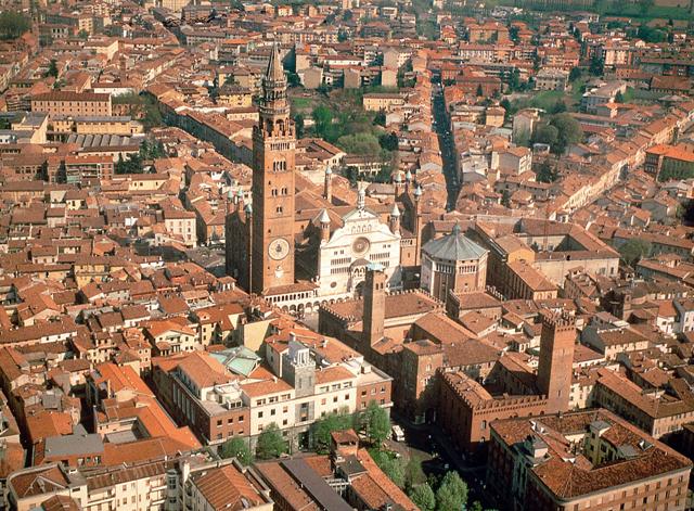
The stage starts in Paipa, still 2500m above sea level, then heads into the Pantano de Vargas, the place where one of the bloodiest and most important battles of the Colombian Independence War took place. They then head into Duitama, best known in the cycling world for hosting the 1995 Cycling Road World Championship, one of the hardest world championship races of all time, both due to the altitude and due to the very difficult circuit selected for the race.
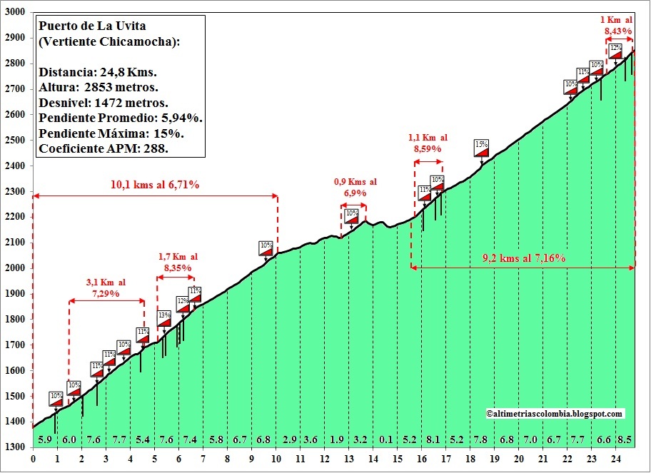
We won't head into the city for long, though. After Duitama we keep heading northeast, taking on the first two climbs of the stage. The second of these peaks at almost 3400m above sea level; the altitude will again be a key factor, but this time riders will have had more time to acclimate themselves. The climb's followed by a very long and irregular descent into the Chicamocha river, followed by the first of the three chained climbs that make up the definitive part of the stage: the long and difficult climb to La Uvita, with two fairly steep sections separated by about 5km of false flat in the middle. Attacking here will be risky, but a good attack will be very hard to chase after, so it may be worth it.
UVITA+por+Chicamocha.jpg

The second climb of the trifecta, San Mateo, is also the easiest one. A gradual climb with slopes constantly around 6%. Not too steep, but more than enough to keep the leader's group on edge.
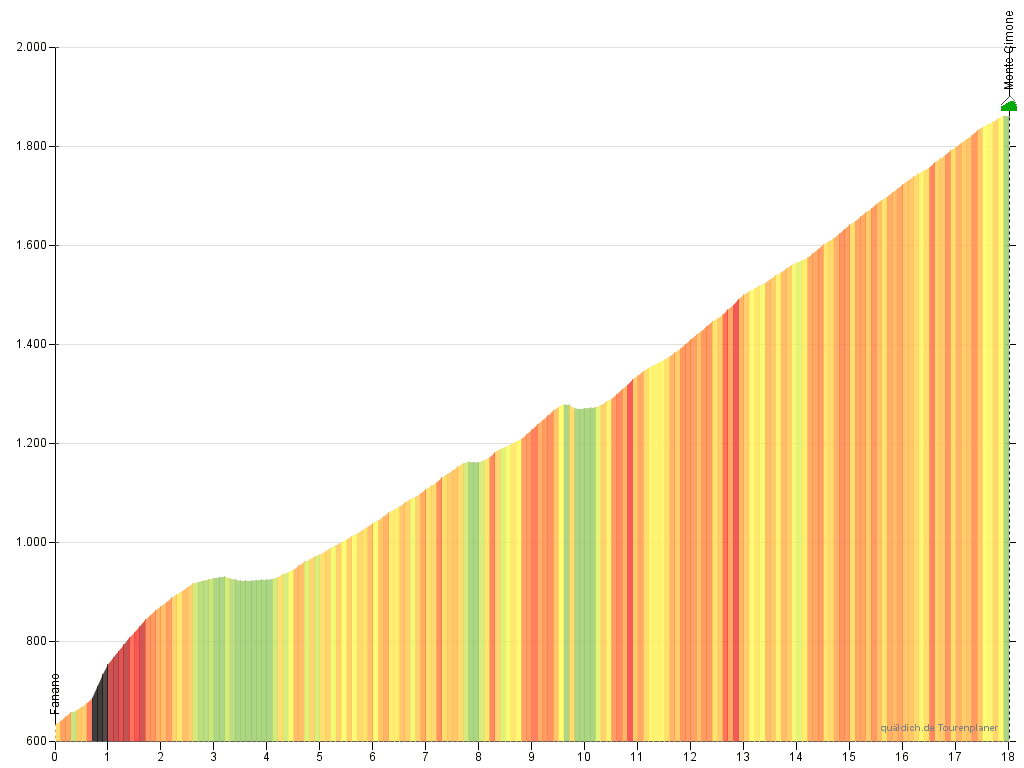
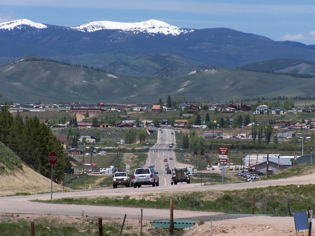
After San Mateo we reach the foot of the final climb of the stage, up to Güicán, on the slopes of the Ritacuba Blanco, the tallest peak of the Cordillera Oriental. The mountain is one of Colombia's few snow-covered peaks, but global warming is making the snow line retreat upwards at an alarming rate. If trends remain as they are, the snow will be all but gone by 2025.
PbmopzI.png

The ride up to Güicán is pretty irregular, with short steep sections sloping up to 10% separated by false flat zones. The slopes even out a bit towards the end, with the final 4km of the climb constantly around 7%. GC contenders will look to break their group apart with a strong attack in this climb. If any contender shows weakness in any of the climbs at the end of the stage, though, all bets are off; teams should get filtered out by the mountains, and the constant climbing and descending throughout the last 120km of the stage means that catching up will be very difficult.