• The Cycling News forum is looking to add some volunteer moderators with Red Rick's recent retirement. If you're interested in helping keep our discussions on track, send a direct message to @SHaines here on the forum, or use the Contact Us form to message the Community Team.

    In the meanwhile, please use the Report option if you see a post that doesn't fit within the forum rules.

    Thanks!

Race Design Thread

Page 240 - Get up to date with the latest news, scores & standings from the Cycling News Community.
Re: Re:

Gigs_98 said:
Giro_2012_Falzes-Cortina-dAmpezzo_profile.jpg

;)

Yes, but start in Brixen please with Würzjoch the first climb. ;)

D1Hl6b3.png
 
Deutschland Tour
Stage 1: Berlin - Halle, 177 km

The Deutchsland Tour/Tour of Germany has been rebooted, this time with a 9 day-race, built around about the same format as earlier. In this version they have chosen to stay entirely within the borders of Germany, which means none mountain stages in Austria like the last version of the race.

Stage 1 starts in the capital of Berlin, and moves in a southwestern direction. The stage is almost completely flat without any categorized climbs, which means that this will most likely be a stage for the sprinters. The stage finish is in Halle, the largest city of Saxony-Anhalt.

Map:
gKaV3zu.jpg


Profile:
GraUcJj.jpg
 
Deutschland Tour
Stage 2: Weimar - Grosse Inselberg, 232 km

This stage is the first real test for the GC contenders in this Deutschland Tour. A 232 km long medium mountain stage with 8 categorized climbs, 6 of them in the last 80 kms of the stage. The riders starts in Weimar most for giving its name to the Weimar Republic, the designation used for the German state between 1919 and 1933, and also for being the home of Germanys most famous writer, Johann Wolfgang von Goethe.

The riders will have little time enjoying Weimar's historical sights, as they head out for a long and demanding stage. The first part of the stage heads in a southern direction until hitting the forrested area of hills and mountains named Thüringer Wald. From here the peloton will turn and move northwest along up and down the hills of Thüringer Wald.

The real difficulty starts after about 145 km when they start the climb to Grosser Beerberg, the highest mountain in Thüringer Wald. From that point, there are few flat sections of the rest of the stage. The climbs aren't very steep or long, but the totalt amount of height meters and the length of the stage should have made its mark on the riders when they start the last climb to Grosser Inselberg. The last climb is probably not tough enough to create some decisive gaps in the GC, but will definitely be a pointer on which of the GC contenders who are in shape for this tour.


Climbs:
71 km: Oberweissbach, 8,4 km, 4,6 %
100 km: Neustadt am Rennsteig, 10,9 km, 3,3 %
152 km: Grosser Beerberg, 6,3 km, 6 %
170 km: Ruppberg, 3,2 km, 6,2 %
194 km: Seligenthal, 2,3 km, 7,6 %
205 km: Brotterode, 7,1 km, 4,3 %
215 km: Rennsteig, 3,1 km, 5,8 %
232 km: Grosser Inselberg, 6 km, 6 %

Profile:
dqlDFro.jpg


Map:
fI8bvGn.jpg
 
Deutschland Tour
Stage 3: Jena-Bayreuth, 188 km

The Tour continues southwards, on this stage moving into Bavaria/Bayern. The stage could be characherized as hilly with 4 categorized climbs, of which the last climb to Lankendorf could be decisive for the stage. A breakway could have a decent stage to stay clear of the peloton as the last part of the stage probably doesn't suit the sprinters especially well.

After heading straight southwards for the most of the stage, the route loops around Bayreuth and approaches the town from the east. About 12 km from the stage finish, the riders will have to face the short, but very steep climb to Lankendorf. This is perfect spot for the puncheurs to attack, and at the top of the climb there is only 11 kms to the finish in Bayreuth.

Climbs:
40 km: Peutchsen, 5,4 km, 4,9 %
120 km: Grosser Waldstein, 3,7 km, 5,2 %
160 km: Bischofsgrün, 2,7 km, 5,9 %
177 km: Lankendorf, 1,1 km, 12 %

Profile:
bLUch9h.jpg


Map:
Lx1ff2W.jpg
 
Deutschland Tour
Stage 4: Landshut-Berchtesgaden, 206 km

The queen stage in the Bavarian mountains finishing in Berchtesgaden, famous for Hitler's retreat at Kehlsteinhaus, probably better known as the Eagle's Nest. From Landshut the first two thirds of the stage is mostly flat and relatively easy. The difficulty starts with about 60 kms left of the stage when the riders are nearing the finish town of Berchtesgaden.

The first two climbs aren't particularly difficult. It's first only a few kms from Berchtesgaden where hell really awaits. Instead of heading straight into the town, the riders will have to loop around, first doing the extremely steep climb to Hinterbrand which averages more than 12 % for 4,5 kms.

This is just the first test before descending and immidiately starting the last climb to Rossfeld. The first part of this climb is also very steep with several km long sections of 11 and 12 %. With Hinterbrand in their legs, this is a climb where it's possible to have a complete meltdown and lose a large amount of time. From the top of Rossfeld there is a 13 km descent to the stage finish in Berchtesgaden. This is the type of stage where action is expected!

Hinterbrand:
HinterbrandW.gif


Rossfeld:
RossfeldS.gif


Climbs:
146 km: Scwarzbachwachsattel, 5,3 km, 6,7 %
153 km: Schwarzeck, 2 km, 8,7 %
172 km: Hinterbrand, 4,5 km, 12,3 %
192 km: Rossfeld, 8,8 km, 9,3 %

Profile:
Uq1pHgw.jpg


Map:
Ts9Tnn0.jpg
 
Deutschland Tour
Stage 5: Rosenheim-Garmisch Partenkirchen, 151 km

After the hellish stage on the day before, this is a shorter and easier stage, but not completely without difficulties. The stage starts in Rosenheim and the route takes the riders along the outskirts of the Alps, mainly avoiding going into the mountains and tougher terrain.

The route takes the riders to one of the best known ski resorts in Germany, namely Garmisch Partenkirchen, known for the 1936 Winter Olympics and for hosting the yearly New Year's Day ski jumping competetion as a port of the Four Hills Tourament. But the finish isn't in Garmich, but above the town at the lake of Eibsee. This means a short 2 km climb to the stage finish, a climb perfectly suited for puncheurs. At Eibsee they can enjoy a magnificent view of Zugspitze, the highest mountain in Germany.

Zugspitze from Eibsee:

zuspitze-eibsee001.jpg


Climbs:
30 km: Sudelfeld, 13,2 km, 4,5 %
151 km: Garmisch (Eibsee), 2,4 km, 8,3 %

Profile:
DaDJN1U.jpg


Map:
nKXx0VW.jpg
 
Deutschland Tour
Stage 6: Oberau-Reutte, 42 km ITT

Stage 6 is the only ITT of this Deutschland Tour, and it's both long and demanding for a one week tour. The riders are still in Bavaria and starts the ITT from Oberau, just north of Garmisch. The route takes them over Ammer-Sattel, a rather gentle climb in terms of steepness, but it's still about 400 height meters. From here they descend to the stage finish in Reutte. The length and relatively low gradient of the climb should make it possible for the better time trialistis of the GC contenders to gain some time on the more pure climbers who surely benifitted from the extremely steep climbs on the stage to Berchtsgaden.

Map:
cOPdqmB.jpg


Profile:
JZqMRaT.jpg
 
Deutschland Tour
Stage 7: Kempten-Tübingen, 192 km

If there is something that could be called a transistional stage on a one week tour like DT, this stage is surely it, moving from the Alps to the mountains in Schwarzwald. The route moves through Badem Württemberg and has two categorized climbs, but both so far from the stage finish that it is possible that the stage could end in a mass sprint. Should be a quiet day for the GC contenders, awaiting another tough mountain stage on the next day.

Climbs:
110 km: Gauingen, 3,8 km, 5 %
162 km: Ringingen, 2,2 km, 6,4 %

Profile:
4KSfrHd.jpg


Map:
HMEdY4z.jpg
 
Deutchland Tour
Stage 8: Freudenstadt-Feldberg, 205 km

The second queen stage of the tour, this time in the mountains of Schwarzwald. Starting in Freudenstadt, at the northern outskirts of the mountainous area, the route moves southwards through the Schwarzwald. A total 7 categorized climbs with 50 kms of climbing and almost 4000 height meters makes this stage a real test for the favorites in the GC.

The first four climbs will contribute to softening the riders legs, but the first real test starts after about 140 km with the climb to Kandel from Waldkirch. Probably the toughest climb in the Schwarzwald, this will probably reduce the size of the peloton significantly. After descending there is an about 10 km long fairly flat section before starting the last two climbs of the day.

First to Notschrei a climb of just over 9 kms at about 7 % followed by the last climb to Feldberg. This climb isn't very difficult, but the large amount climbing earlier on the stage makes it possible to create some gaps on Feldberg, especially with aggresive riding on Notschrei. The toughest part of the last climb is the middle section which averages just shy of 8 % over about 4 kms. The last part to the top and stage finish at ski resport at Feldberg is somewhat easier.

Climbs:
49 km: Zuflucht: 7,8 km, 8,6 %
69 km: Freiersberg: 5,1 km, 6,6 %
100 km: Moosenmättle: 7,2 km, 6,8 %
116 km: Buchenreck: 4,3 km, 7,9 %
150 km Kandel: 10,6 km, 8,2 %
187 km: Notschrei: 9,2 km, 6,9 %
205 km: Feldberg: 10,2 km, 5,2 %

Profile:
qHBsueb.jpg


Map:
CoNRhUc.jpg
 
Deutschland Tour
Stage 9: Titisee-Stuttgart, 180 km

The last stage of this Deutschland Tour. The stage starts in Titisee-Neustadt and the route heads in a northeastern direction the whole day. There are two categorized climbs, both in the first third of the stage. After this the route is relatively flat, and this should be a stage for the sprinters. The stage and the tour finishes in Stuttgart, the capital and largest city of Baden Württemberg and the sixth largest city in Germany.

Climbs:
10 km: Schwärzenbach, 3,5 km, 5,3 %
61 km: Altenburg, 2,1 km, 7,4 %

Profile:
Gvq4yTR.jpg


Map:
zuGhPUG.jpg
 
Summary Deutschland Tour

Stage 1: Berlin - Halle, 173 km
Stage 2: Weimar - Grosser Inselberg, 232 km
Stage 3: Jena - Bayreuth, 188 km
Stage 4: Landshut - Berchtesgaden, 206 km
Stage 5: Rosenheim - Garmisch (Elbsee), 151 km
Stage 6: Oberau - Reutte, 42 km ITT
Stage 7: Kempen - Tübingen: 192 km
Stage 8: Freudenstadt - Feldberg, 205 km
Stage 9: Titisee - Stuttgart, 180 km

Total: 1569 km

2 mountain stages (Berchtesgaden and Feldberg)
1 medium mountain stage (Grosser Inselberg)
2 hilly stages
3 flat stages
1 TT

5 cat. 1 climbs (Hinterbrand, Rossfeld, Kandel, Notschrei, Felderg) and 10 cat. 2 climbs
 
Jun 30, 2014
7,060
2
0
Visit site
Giro dell' Euregio stage 5; Bolzano/Bozen –Trento; 148km
stage51.png

Stage52.png

I'm finally able to finish my Giro dell' Euregio
After a hard MTF the last stage of my Giro dell' Euregio will be a short, hard stage with a downhill finish.
Shortly after the Start in Bozen/Bolzano the first climb of the day, Medelpass/Mendola already starts, the actual climb starts after 10km of racing, 14.6km at 6.5%.
MendolaE.gif

mendelpass--kalterer-see---ueberetsch-suedtirol.jpg

If the break hasn't already formed we could get a brutal first ascent.
Right after the following descent the next climb already starts, Passo Predaia from North, not the hardest climb in the world, but still 11.5km at 6.1%.
PredaiaN.gif

After a long descent we have 7km of false flat, then the Fai della Paganella-Andalo combination that we already saw in this years Giro d'Italia starts.
PW_T16_S02_Paganella.jpg

PW_T16_Andalo_ukm.jpg

For the next 35km we have a mixture of (mostly going slightly downhill) false flat and shorter downhill sections, the the final climb to Ciago starts, 4.5km at 6.5%.
Ciago:
26597145.jpg

The climb ends with about 14km to go, then we have 9km of gentle downhill/false flat and a bit of rolling terrain before the actual descent to Trento starts.
This is the final stage of my Giro dell' Euregio, so the riders should go all out, if someone really wants to gain a big amount of time he should have at least 1 teammate in the breakaway, send them on the attack on the first half of the stage, then attack on the Fai della Paganella and try to rech your teammate, if someone wants to win the races, has to gain a big amount of time that should be the most obvious strategy. Having a strong team will also be crucial, if the race leader gets isolated early it could be a really bad day for him.
Bolzano/Bozen:
4218979767.jpeg

Tento:
Trento_-_dall_alto.jpg

trento_trento.jpg

I probably won't post any stage races in the near future, but I've designed a few WC RR routes in various towns on different continents, I'll probably post at least one or two of them.
 
Gigs_98 said:
OlavEH said:
Gigs_98 said:
The downhill finish in Covara this year was pretty good too. Generally there are endless possibilities in the Dolomites. Downhill finishes in Corvara, Canazei, Cortina, Ortisei, Brixen,... or mtf's on Pordoi, Fedaia, Gardeccia, Zoldo Alto, Tre Cime, San Pellegrino,...
And for every possible finish there are many different climbs to put before it. For example 3 passes start in Corvara, 4 if you count Falzarego and Valparola as two passes.

I know. The possibilities are endless! A combo I would like to see is Duran-Staulanza-Giau, and then preferrably followed by a downhill finish to Cortina. There isn't much flat terrain between these climbs.
Giro_2012_Falzes-Cortina-dAmpezzo_profile.jpg

;)

I'd prefer Duran>Staulanza>Valparola/Falzarego>Giau>Fedaia>Pordoi>descent

I don't know how long that would be but I think it's definitely not too long and you may even put stuff before it if you're willing to go crazier. You could also switch Giau and Falzarego, probably gets less flat and the stage would be less backloaded, but then you don't get action before the Fedaia I think.
 
Olav, great minds think alike - although your Deutschlandtour is one week like the real race was whereas I went for a two week version, it seems both of us had some similar ideas - obviously I think anybody who's tried to produce a selective Deutschlandtour has been drawn to the Berchtesgadener Land, but the direction of travel and the Feldberg finish with Kandel and Notschrei preceding just chains together so well it's irresistible - you arrived at Kandel from the opposite direction to me which enabled you to use Zuflucht, which is a really nice climb I couldn't crowbar into my route. Your transitional stage into Bavaria (the Bayreuth stage) is better than my equivalent stage definitely, and both of us are drawn to Garmisch-Partenkirchen, although I will admit that my fixation with wintersport played a big role in that; indeed I've used Garmisch and Mittenwald both on multiple occasions. The only nitpicking I'd do with what is a very nice route is to suggest taking the southwest rather than southeast road out of Schwarzbachwachtsattel as this enables you to use the full Hochschwarzeck climb for another cat.2 leg-softener, and also that while you may have made a conscious decision bearing in mind it's day one and also considering Germany churns out a lot of high quality sprinters (and we route designers don't seem to care much for those!) so it might be good for the race, Halle offers several options to add some cobbles if you wanted a more selective rouleur stage. Overall though, a very nice and quite well-balanced route with a good length TT (German races always seem to like a good power TT so it's a nice nod to tradition) to make the mountainous stages need to be raced hard.
 
this is my OCD at work, but while it is the Zugspitzmassiv in the picture, the Zugspitze itself is further to the right looking from the point where the picture was taken

and come to think of it, the lake looks too small to be Eibsee. looks more like Frillensee to me
 
TOUR DE FRANCE

(Tue) stage 10: Albi - Béziers, 179 km

MjQGnLg.png

XsqzOcV.png


After the rest day we continue in the South of France. There is a bit of climbing on the program today, as we cross Haut Languedoc, the southernmost part of Massif Central.

gNqpCEW.jpg


The highest point of the day is Col de l'Espinouse, which is an easy climb from the north.

Espinouse2N.gif

Espinouse_26.jpg


The final 30 km are flat and i expect the group of the day to be caught by the peloton. The final 1,5 km are slightly uphill and leads to the picturesque high part of town. Finish is at the lovely Allées Paul Riquet.

zynIXeP.png


Albi
OTORmRF.jpg


Béziers
MIgHw5P.jpg
 
My versions of some stages of Giro d'Italia 2017 with same start and finish locations
Stage 14(don't get confused by it,the real stage of 2017 Giro stage 14 starts in a road between Castellania and Tortona while mine starts in Tortona):
http://www.la-flamme-rouge.eu/maps/viewtrack/hd/86675
Alpe di Noveis:
NoveisE.gif

Valico di Bielmonte:
BielmonteE.gif

Galleria Rosazza:(last 7 km)
RosazzaN.gif


Stage 15:
http://www.la-flamme-rouge.eu/maps/viewtrack/hd/86431
Valico di Valcava 15.23 Km al 7.5%
Foppo 4.81 Km al 7%
Sant'Antonio Abbandonato 6.05 Km al 9.5%
Miragolo San Salvatore 9.28 Km al 6.8%
Selvino 7.13 Km al 5.2%
There are also two climbs at 2.64 km %8.4 and 2.01 km %9.9 between Sant'Antonio Abbandonato and Miragolo San Salvatore

Stage 18:(the bump before Pordoi and the bump between Pordoi and Duran are glitches because of tunnels)
http://www.la-flamme-rouge.eu/maps/viewtrack/hd/86394
Passo Pordoi
Passo Duran
Forcella Staulanza
Passo Fedaia
Passo Sella
 
TOUR DE FRANCE

(Wed) stage 11: Sète - Arles, 158 km

S1aw0KF.png

LNW5EYs.png

0NJFuSG.jpg

pwYlW0v.jpg


This is the flattest stage of the race, but 28 km of gravel should guarantee that it won't be boring.

The salty lagoons along the coast of the Mediterranean Sea take center stage today.

FTnZo3p.jpg


After passing Étang de Vic, Étang de l'Or and some smaller lagoons we enter Camargue, where the rest of the stage takes place. Part of the route goes through a regional nature park, so i'm not quite sure if a bike race would be allowed here. But since there is massive heavy industry just outside of that park (around Fos sur Mer, mostly oil and chemical industry) i don't think a bike race would be the biggest environmental threat here.

The riders don't have time to admire flamingos and wild horses, because after 90 km the first sector of sterrato begins. It leads along the western shore of Étang de Vaccarès and is 11 km long.

06RQerH.jpg


tVG8EEb.jpg

bZZSUwk.jpg

KeG2Gpo.jpg

Lc4JJdP.jpg

ZqdYjhj.jpg


Unlike much of the sterrato in Italy this one in Camargue is dead flat. It's perfect for the rouleurs and classics men of the peloton. Also consider that the riders are totally exposed to the wind. Remember how strong the Mistral blew at the Tour 2016?

carte du mistral:
Carte_du_mistral.png


Between the two sectors of gravel lie 5 km of tarmac and Saintes Maries de la Mer, the capital of Camargue.

saintes-marie-de-la-mer1.jpg


The second sector of sterrato is 17 km long and is situated on the narrow stretch of land between the Mediterranean Sea and the Étang de Vaccarès.

mf5ZFOJ.jpg

YJJcGZd.jpg

2wbJSm9.jpg

vdIFoLo.jpg

co3Zfl7.jpg

FPOsSqt.png

g8WfqQJ.png


The final 35 km are on tarmac. First along the eastern shore of Étang de Vaccarès...

4nIalOk.png


... then into Arles, finishing on Boulevard Émile-Combes.

Sète
Photo1_Page1.jpg

CWXkpMi.jpg


Arles
xv2kfwQ.jpg

120179632.jpg


P.S. Panoramio seems to be closing in a few days. Very sad.
 
Yeah, but the first section will be brutal with a tailwind and everyone pushing hard to get in position for the second one. Very nice. As much as teams will be important, the design does favor the strongest and should result in a more 'fair' selection.
 
It's a awesome but brutal stage.
a stage like this, in the middle of a Tour, with those long sterrato sectors and expectable strong winds, probably two thirds of peloton wouldnt arrive within time limit
 
OK... what with both the real life Giro and Tour putting forward some disappointing routes, it's time to take solace in the route designing world and try to see what we can do with Grand Tour designing. And as so often is the case, what's drawn my imagination is La Vuelta. It offers so much more opportunity because a) its space requirements are so much less than the Tour, making it easier to come up with new ideas (even if with finishes like Mûr-de-Brétagne the Tour has shown that if it needs to it can cram everything in pretty well), b) whereas the Tour is actually narrowing down its options as previously available climbs and stations cease to be involved and we get an increasingly repetitive route, La Vuelta has a long tradition of using the same climbs leaving much of the country comparatively undiscovered, a situation they are rapidly going about chanigng and c) the Vuelta tends to have municipalities and regions paying for stages rather than individual towns or stations, leading to a bit more flexibility and the use of tourist attractions or major sponsor spots as stage towns.

This will be my ninth Vuelta, and I've still got plenty of variety available to me. This particular route, for example, does not touch many traditional mountainous areas of the Vuelta such as the Catalan Pyrenees or the entire province of Asturias, and in fact the number of "real" mountain stages is limited, but I think I've come up with a well-balanced and creative route that breaks some of the formulae and showcases some innovation.

As ever, I forbid myself repetition in MTFs, and therefore the following are now off limits:

Galicia: Cabeza de Manzaneda from Manzaneda
Asturias: Lagos de Covadonga, Angliru, La Cobertoria from Pola de Lena, Monte Naranco from Oviedo, Santuário del Acebo from Las Cuadrielles
Cantabria: Fuente del Chivo, Cueva el Soplao from Rábago
Castilla y León: El Morredero from Ponferrada, Lagunas de Neila from Neila (north not east), La Covatilla, Plataforma de Gredos, Esquí de Lunada from Espinosa
Comunidad de Madrid: Morcuera from Miraflores
Navarra: San Miguel de Áralar from Etxarri-Aranatz
Aragón: Candanchú from Jacá, Cerler, Valdelinares via San Rafael
Catalunya: Coll de Pal, Mont Caró, Santuari de Queralt
Valencia: Xorret del Catí, Font de Partagas
Murcía: Morrón de Espuña from Alhama de Murcía
Andalucía: Sierra de la Pandera from Valdepeñas de Jaén, Haza del Lino from Rubite, Trevélez via Castañár, Cumbres Verdes
Canarias: Teleférico del Teide from Guía de Isora
Andorra: Llac d'Engolasters, Arcalis, Els Cortals d'Encamp
Gibraltar: El Peñón de Gibraltar
Portugal: Alto da Torre from Seia, Senhora da Graça

As you can see, therefore, still plenty of choice is available. I have tried to keep true to the spirit of the Vuelta while simultaneously innovating - therefore there are some brand new summits and an unusual route pacing, as well as a collector's item not seen in over 20 years. Although the stages I would describe as "true" high mountain stages are limited in number (between 3 and 6 depending on your definitions), there is still a nod to the nature of the Vuelta in its current guise; after a couple of routes which were very lacking in Muritos, here they are back with a vengeance, with nine stages that finish uphill, though only four are what you'd call mountaintop finishes.

So without further ado, La Vuelta a España, take 9

Stage 1: A Coruña - A Coruña, 184km
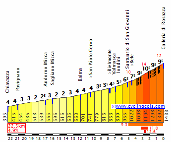
akhipv.png


124gh2h.png


GPM:
Alto da Orela (cat.3) 5,5km @ 5,5%
Alto do Xalo (cat.3) 6,0km @ 6,1%
Alto de Santa Locaia (cat.3) 2,4km @ 11,1%

That's right, I'm starting with a road stage. In the world in which my races inhabit this has been done fairly recently with the Toledo circuit race that featured in Vuelta number... was it 6? However, in the real world, this is a pretty rare sight. The last time the first stage of the Vuelta wasn't a team time trial was 2009, when the riders had a prologue on the Assen motor racing circuit, and it was 2007 when the riders last began the race with a road stage. Coincidentally, that was also in Galicia, when a course beginning and ending around Vigo was won by Daniele Bennati on day one. Despite all the great potential terrain around there, it was a disappointing course which led to the sprinters prevailing.

That's unlikely on the course I have prepared for stage 1, dedicated to the great Coruñés climber Vicente López Carril, former Tour podium rider who died at the age of 37; this is an outright hilly stage that means riders will have to be awake to the challenges right from the get-go.

A-coru%C3%B1a.jpg


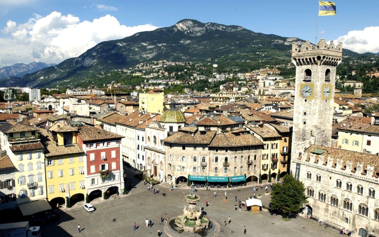
The start and finish are on the Paseo Maritimo, which you can see in the background there, overlooked by the National Monument and UNESCO World Heritage Site that is the Torre de Hércules, a Roman lighthouse that stands a watchful guard over the city. This allows for a very scenic and suitable setting for something as grand as a GT beginning, to potentially take precedence over the previous Galician Vuelta beginnings in 2007, 2013 and 2016. The city has a population of around 400.000 in its metropolitan area, and its sporting credentials are significant, with its football club Deportivo La Coruña being one of the few Spanish sides to have upset the Barcelona-Madrid hegemony this century. La Vuelta last visited for a sprint stage in 2014, a stage with a run-in from which I have borrowed but beefed up.

The first part of the stage, however, is to head away from the city and follow the coastal road around in the direction of Ferrol, before climbing up away from the Atlantic and onto the plateau that makes up much of the central Galician terrain.

fotoindex2.jpg


This entails climbing out of Pontedeume on the road to 
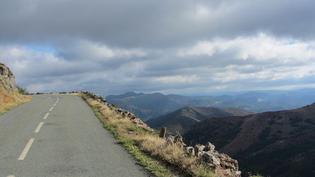
A Anta. I have put the mountains points at A Orela, but we do climb all of that climb. As you can see from the pictures, some scenic views but nothing too challenging. After a period of flat, there's then a second, similar but slightly shallower, uncategorized climb as we circle around Betanzos. However it is in the final third that the stage comes to life.

First up we have Monte Xalo, the second categorized climb of the day, at around 6km at 6%. Only the first kilometre - at 9% - is a real challenge, and it is rather two-stepped. As you can see there are some steep ramps - up to 14% - but coming over 50km out it isn't likely to cause much action. The same cannot be said of the ensuing carnage on Santa Locaia.

SantaLeocadia+%25284%2529.jpg


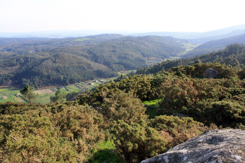
The views from here down into the valley of Arteixo are pretty spectacular, but the riders won't be enjoying themselves here, because they'll be learning that much like the rest of the north coast of Spain, A Coruña province is chocked full of some pretty nasty ramps, and while this part of Galicia isn't perhaps as relentlessly mountainous as, say, Asturias or Gipuzkoa, you're never more than a stone's throw from a Murito nonetheless.

santalocaia789.gif


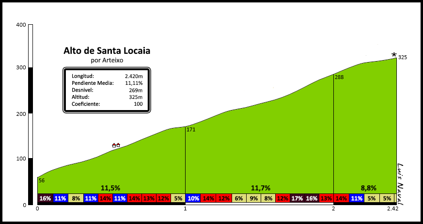
Cresting with 31km remaining, 2,4km averaging 11% with a max of 18% right at the very bottom should get rid of most of the sprinters, and lead to some intriguing battles for selection. Does a rider with any GC ambitions want to take risks at this point in the race? Probably not, but they also can't let anybody get too far up the road lest they surprise as the race goes on, because the kind of rider who can get over this climb has at least some climbing chops. There's also the small matter that at the base of the (gradual) descent, with 22km remaining, is the town of Arteixo where there will be bonus seconds available at the intermediate sprint.

2NHZ57jRr6mKMiVhk87pXHYQ80h1ZiN-gb-wMpT_ExwN36Gz7Se6FNY4GZCeKvLbUgSYUWg=s673-fcrop64=1,00000000ffffbfb0


Following on from Arteixo, however, there may be no more categorized climbs but that doesn't mean that the climbing stops. Oh no, far from it. In fact, this is a nice little Worlds tune up in some ways, depending on the course, as we have a nice little hilly run-in, with two back to back uncategorized ascents, the first coming 16km from the line, the last just over 9km out. Helpfully for the prospective racing, the former is the harder climb as well, with a first 1,25km at 7,5%, whereas the final climb of the day is a fairly consistent 1900m at 5%. Controlling this one could be tough as many sprinters will struggle to get back on after Santa Locaia, so marshaling those final climbs when the GC men don't want to lift a finger when they don't have to could make an interesting final 30k here.

2mc6rzl.png
28rjp1g.png


The final climb, to the urban Parque de Bens, offers some wonderful views back into the city, and a max gradient of just 8% so it's not one for the Puritos of the world, giving a platform for attacks from a variety of styles of classics rider.

bens_coruna.gif


The final few kilometres after the Parque Bens climb are along the coast, passing the Playa de Oza before finishing in front of the Torre de Hércules. No circuit finish here but, seeing the start and finish of what should be one of the most interesting GT opening stages in recent memory at such an iconic location should make this a pretty strong grand départ nonetheless.
 

TRENDING THREADS