• The Cycling News forum is looking to add some volunteer moderators with Red Rick's recent retirement. If you're interested in helping keep our discussions on track, send a direct message to @SHaines here on the forum, or use the Contact Us form to message the Community Team.

    In the meanwhile, please use the Report option if you see a post that doesn't fit within the forum rules.

    Thanks!

Race Design Thread

Page 259 - Get up to date with the latest news, scores & standings from the Cycling News Community.
TRENTINO TIROL TOUR

This is a take on the new format of the Giro del Trentino, hopefully with a slightly better name than the stupid Tour of the Alps. The new format consists of five racedays (instead of four) and three regions (Trentino, (Nord-) Tirol and Osttirol).

(Mon) stage 1: Trento - Folgaria, 150 km
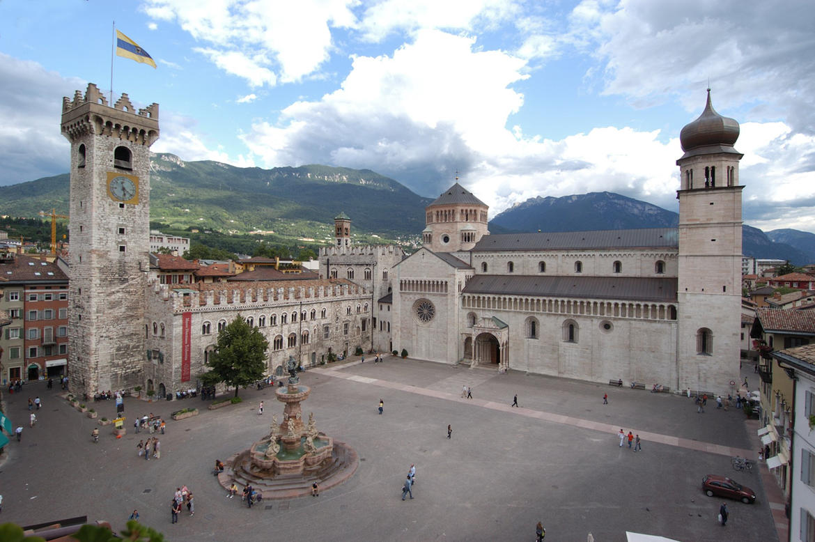
j6yyqDm.png

NWw9riY.png


Trento
Museo-diocesano-tridentino_imagefullwide.jpg


Palù di Giovo (of course birthplace of both Francesco Moser and Gilberto Simoni)
Valle-di-Cembra-Palu-di-Giovo-Ville-di-Giovo-Valternigo-e-Verla-di-Giovo.jpg


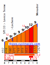
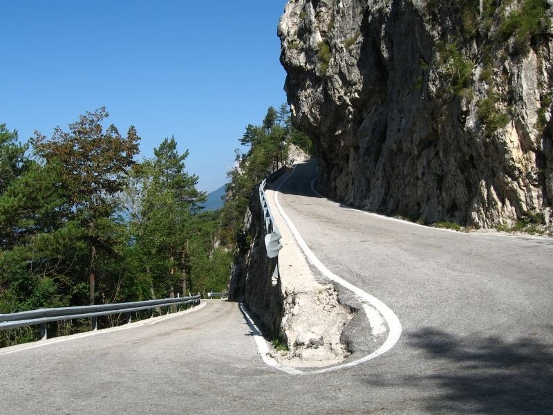
The climb up Val dei Mocheni (Fersental) to Palù del Fersina is 14 km long and at average 6% steep. The main climb of the day is Menador (8,1 km 9,6%), a small, scenic and steep road to Monte Rovere.

Menador (Kaiserjägerstraße)
MenadorN.gif

267b1948fa84309bc99f9c0289cabe44_L.jpg

2500598671.jpg

Xk8XTVv.jpg


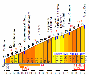
The final 18 km take place on the high plateau of Lavarone. This includes the climb to Passo di Sommo (3,6 km at 7,6%) and the descent to Folgaria. The final 200 meters are uphill.

Folgaria
79229813.jpg
 
TRENTINO TIROL TOUR

(Tue) stage 2a: Folgaria - Rovereto, 23 km ITT

2ltsIrq.png

2xf6N5I.png


The second day sees two split stages. The first semitappa is a downhill time trial to Rovereto. The road is wide and has excellent tarmac. The teamcars can return to Folgaria via Serrada.

a1IfDSR.png

WMYQ6FC.png


(only from Folgaria)
CoeW.gif


After reaching the valley the riders will have to tackle the short but steep climb to the village Saltaria (1,6 km at 11%).

LIi4Awy.png

sNec6H4.png


The final descent is quite technical and leads directly to the center of Rovereto.

fOUg9Vl.png

69f6ecJ.png


Rovereto
9VSvndJ.jpg
 
Well, i guess Pinot will have to attack in the coming stages. Like this one:

TRENTINO TIROL TOUR

(Tue) stage 2b: Rovereto - Molveno, 72 km

rOBveTV.png

3v5Rw7g.png


The first climb is the easy Passo del Ballino.

BallinoSE.gif


From Comano Terme the road climbs in a few steps to Lago di Molveno.

W8Ch0KD.png


The decisice part is the steep, cobbled climb that begins at a bridge in the village of Moline with 10 km to go. It is 1 km long and averages 11,3%. The road is very narrow, so no cars allowed here.

XyYkZaT.png

YlRhzhf.png

bCweCXA.png

r7k016i.png

rhgeMgD.png


Rough cobbles at the top, passing the chapel Madonna del Caravaggio.

6Ji00Cf.png

MD148Ls.png

QvuE62u.png


After the flat part along Lago di Molveno there is a final climb through the center of Molveno (0,8 km at 7%).

hccMyG3.png

FpclNre.png


Molveno
RAhAoTY.jpg
 
Giro d'Italia stage 7: Legnano - Foppolo (145 km)

The Giro goes on with another mountain stage. This time it is in Lombardia, featuring three climbs. The start is in Legnano, not far from Gallarate where the previous stage finished. The route passes through Saronno and Cermenate, with an early intermediate sprint in the latter. The next town is Cantù, after 29 km. The second intermediate sprint is in Lecco, where the Giro di Lombardia finished from 2011 until 2013.

After leaving Lecco, the first climb of the day starts. It's the irregular Culmine di San Pietro, which has stretches up to 10% but also some flat sections. After a long descent with only a few hairpin bends, the second climb of the day starts. No profile for this one, but it's steep: 5 km at 10,4% average. The descent is less steep, but it's technical and on a narrow road. Then, after a flat section of around 7 km, the final climb starts. The first 10 km are gentle with only one steeper section, but the last 11 km have an average of 7% with sections of 10%. The final km is 9% steep. The finish is at the ski resort of Foppolo.

Climbs:
cat. 2, Culmine di San Pietro (22,5 km @ 4,4%)
cat. 2, Brembella (5,0 km @ 10,4%)
cat. 1, Foppolo (21,2 km @ 5,2%)
note: the ascent of Foppolo is marked as cat. 2 on the profile. It should be cat. 1.

zYR330cb.png

IxU0BVR3.png
 
Last edited:
Gigs_98 said:
I really like these early mountain stages. I'm curious about your 2nd and 3rd week since I guess they will probably take place somewhere in southern Italy which is rather uncommon, but something I always find very interesting.
Ha, see, for my second Giro, I was also wanting to go north->south, but it's really hard to build decent mountain stages south of the Apennines ie. ones which use lots of 1st category climbs. I'm also intrigued :D :D

How many rest days are you having? Just two, or three?
 
Vuelta a Espana: Stage 1: Gibraltar, 14 km ITT

My first version of the Vuelta a Espana, and it starts at the southern edge of the Iberian Peninsula, more accurately in the British territory of Gibraltar. Here the Vuelta kicks off with an 14 km ITT. The riders both starts and finish just south of the Gibraltar airport, by Victoria stadium. From here they will loop around the famous Rock of Gibraltar, only with a short detour about halfway up the Rock. The climb doesn't look much on the profile, but it's about 1,5 km at 10 % gradient, followed by a quite technical descent. The climb will surely create some time gaps and make it difficult for a sprinter to wear the leader's jersey in the first stages of this Vuelta.

Profile:
OC4blvR.jpg


Map:
h3hy0ax.jpg
 
Vuelta a Espana: Stage 2: Gibraltar - Marbella, 145 km

Stage 2 starts in Gibraltar and heads directly inland in a northwards direction. The first 50 km is flat before the main difficulty of the stage starts, the 8 km climb to Gaucin. From this point the track continues northeastwards along Sierra Bermeja and to the beautiful cliff town of Ronda. The terrain between about 60 and 120 km is perhaps best described as "lumpy". Only one categorized climb after about 80 km, but never to much flat terrain either. After about 120 km, there is an about 20 km long descent back to the Mediterranean before a flat 7-8 km to the stage finish in the resort town of Marbella.

Climbs:
59 km: Gaucin: 8 km, 6,3 %
83 km: Atajate: 3 km, 6,6 %

Profile:
bnARBjE.jpg


Map:
SFJgrdy.jpg
 
Vuelta a Espana: Stage 3: Marbella - Antequera, 145 km

Stage 3 starts in Marbella and takes the riders northeastwards the whole stage. While stage 2 could be both a possibility both for breakaway riders and sprinters, this stage is more likely to end up in a win for a rider in a breakaway, or perhaps from a peloton of reduced size. The profile of the stage should make it difficult for the more typical sprinters.

The first climb starts almost immediately, after just 3 km. It's also the longest climb of the day, and a breakaway will probably form. The next 55 kms is mostly flat with some gentle and uncategorized climbs. When approaching halfway the second climb of the stage starts, and from here it's mostly up and down the last 75 kms. None of the 4 remaining climbs are especially brutal, but it's very few flat sections, and the there many km of false flats, making it difficult for the riders to use some sections for "rest".

Instead of heading straight to the stage finish in Antequera, the riders will have to loop around the city and climb the last climb of the stage, in the nature reserve of Torcal de Antequera. The top of the climbs is about 14 km from the stage finish. The last 5-6 km are flat only with a small "bump" with about 3 km left.

Climbs:
11 km: Puerto de Ojen: 8,6 km, 5,4 %
71 km: Puerto de Malaga: 5,7 km, 4,3 %
89 km: Las Angosturas: 3,5 km, 6,6 %
112 km: Puerto de la Joya: 3 km, 7,6 %
131 km: Torcal de Antequera: 4,8 km, 6,4 %

Profile:
nxILmLi.jpg


Map:
aUGSCJZ.jpg
 
Vuelta a Espana: Stage 4: Marbella - Granada, 199 km

After the first 3 stages, I would guess that many had a pretty good idea where the riders were heading next, of course towards Granada and the Sierra Nevada mountains. The first mountain stage and the first real test for the GC contenders in this Vuelta.

From the start in Antequera the route takes the riders westwards. The first three quarters of the stage is fairly easy, only with a couple of 3rd category climbs just before halfway of the stage. The decisive part starts with about 60 kms left. Just before reaching the central parts of Granada, the riders turns right at starts the climb of Alto de Monachil. The climb has been used in the Vuelta several times before, mostly before a downhill finish to Granada but also before finishing at the ski station further up at Pico Velata. In 2013 it was also used before a descent and climbing Alto de Hazallanas for stage finish.

This time it's also used in pairing with Hazallanas. After a short descent to Guejar Sierra, they start the latter climb. The average gradient shown in the profile is somewhat misleading due to the short descent halfway in the climb. The last half has an over 5 km long section with an average gradient of over 10 %. Here there should certainly be possible to attack before the descent to the stage finish in Granada. From the top of the climb there is about 17-18 km downhill and 6-7 km flat to Granada.

Climbs:
85 km: Altos de los Bermojales: 4,7 km, 4,8 %
97 km: Puerto de Lucero: 4,3 km, 6,2 %
150 km: Alto de Monachil: 11,9 km, 6,2 %
176 km: Alto de Hazallanas: 14,5 km, 5,8 %

Profile:
9ZwxEDL.jpg


Map:
qbv9e8t.jpg
 
Giro d'Italia stage 8: San Pellegrino Terme - Mezzolombardo (216 km)

The eighth stage (ninth if you count the prologue) starts in San Pellegrino Terme, a town with only 5000 inhabitants, but famous for the San Pellegrino mineral water. After 20 km, the riders enter Bergamo, where (at the moment) Il Lombardia finishes. The stage is flat until the city of Brescia, where the first intermediate sprint is located, but before, Rovato and Ospitaletto are passed through.

When the riders leave Brescia, the first climb of the day starts, to Sant'Eusebio (salite.ch names it San Eusebio and I also did so on the profile). The riders are now within the mountains, but the stage remains flat for quite some time. The second intermediate sprint is in Vestone, while the feed zone is a bit later in Lodrone. The riders also ride alongside the Lago d'Idro.

After 150 km of racing, the second climb of the day starts. The KOM points are not awarded at the highest point but in Roncone, because the last few kilometers are false flat. After a short descent to Tione di Trento, there is some false flat, interrupted by a short dip. The route joins this profile at the 18 km mark, but also goes through a tunnel. The climb to Andalo consists of the last 5 km of the aforementioned profile, plus the last 2,5 km (from right to left) of this profile. The riders follow the rest of the profile from right to left, taking the downhill of the Andalo climb. It was climbed in stage 16 of the 2016 Giro. The last part of the descent contains 9 hairpin bends, which are close to the finish line in Mezzolombardo. My inspiration for this stage was stage 7 of the 2009 Giro, won by Edvald Boasson Hagen. Like that stage, this one is a stage with a downhill finish that non-climbers can win.

Climbs:
cat. 3, Sant'Eusebio (9,1 km @ 3,6%)
cat. 3, Roncone (5,0 km @ 5,1%)
cat. 3, Andalo (7,5 km @ 4,1%)

jpNsKTkq.png

6sjgQkbr.png
 
Okay, so seeing that everyone is focused on north->south Giri :)D) I'm going to work on my TdF, which is a bit clunky at the minute. My first two weeks are polished & ready, but the last week is miserable, purely because I'm trying to make a monster mountain stage in the Massif Central (visiting/coming close to the other ranges earlier & don't like repeatedly visiting eg. the Alps), but I'll see what I can think of...
 
Vuelta a Espana: Stage 5: Granada - Jaen, 187 km

Another hilly stage in the southern Spain. The stage starts in Granada and heads north towards the town of Jaen. The area has been frequently visited by the Vuelta, especially with MTFs at Sierra de la Pandera. This time the route takes the riders of the outskirts of the mountain. There are a total of six categorized climb on the stage, where the two first after about 40-50 kms.

These climbs are followed by an easier section before two more climbs brings the riders into the Sierra de la Pandera mountains. Here they could have turned right and finished at the top of Pandera, but the route intead takes the riders over Puerto Viejo before descending to Martos. From here there is a 60 km loop around Jaen with four more climbs, of which to are categorized, before the stage finish in Jaen.

The last climb is just before the stage finish and will probably be the decisive point of stage. The profile of the stage combined with the tough mountain stage the day before makes this on the best chances for a breakaway to succeed in this version of the Vuelta. The last climb before the finish in Jaen is an advantage for punchy riders to get a stage win.

Climbs:
39 km: Puerto Pelada: 7,1 km, 6,2 %
50 km: Puerto Cequia: 3,4 km, 7,1 %
92 km: Puerto Locubin: 8,3 km, 5,1 %
104 km: Puerto Viejo: 3,5 km, 7,5 %
151 km: Puerto Jabalcz: 3 km, 5,7 %
185 km: Jaen: 3,2 km, 4,6 %

Profile:
NrQpKaV.jpg


Map:
ADlH9OE.jpg
 
Vuelta a Espana: Stage 6: Ubeda - Albacete, 206 km

Well, really not very much to say about this stage. The riders have moved from Jaen to Ubeda for the start of the stage. This is really a transfer stage where the route takes the riders almost directly northeast over "Meseta Central" to Albacete. There are no categorized climbs on the stage, and it is very likely that it will end in a mass sprint, since this is one of few obvious chances for the more typical sprinters.

Profile:
USF15vE.jpg


Map:
29tC48M.jpg
 
Vuelta a Espana: Stage 7: Albacete - Xorret di Cati, 217 km

No Vuelta without a "murito"? And this time it's one of the most and classic famous ones, namely Xorret di Cati. The stage starts in Albacete, and the first 80 kms are flat. After passing through the small town of Ayora, the first climb of the stage starts, to Alto del Pino. The next 40 kms are hilly, but no categorized climbs before Alto de el Portillol.

The stage continues southwards in a hilly terrain with new 3rd category cimbs after 168 and 197 kms. After descending from Puerto de Onil, there is a 7-8 km flat section to the small town of Castalla where the climb to Xorret di Cati starts. Only 4 kms long, but with an average gradient of 11 %, it will surely hurt, and create opportunities for the GC contenders to attack. The small and light riders like Purito and Valverde will be favorized.

Climbs:
91 km: Alto del Pino: 13,2 km, 3,9 %
137 km: Alto del Portillol: 11,4 km, 3,7 %
168 km: Alto de Beneixama: 5,9 km, 6 %
197 km: Puerto de Onil: 6,9 km, 3,8 %
215 km: Xorret di Cati: 3,9 km, 10,9 %

Profile:
UHHSRmg.jpg


Map:
QsAr6ct.jpg
 
Vuelta a Espana: Stage 8: Castellon de la Plana - Valdelinares, 169 km

Between stage 7 and 8, the first rest day of this Vuelta takes place. During the rest day, the riders have moved north along the Mediterranean coast to Castellon de la Plana where stage 8 starts. This is the first MTF in this Vuelta, and is very typical mountain stage in the Vuelta, especially for the mountains surrounding the central part of the country; fairly long to long but not very steep climbs.

From the coast, the race heads northwestwards inland towards the mountain ranges of Sierra de Gúdar, the easternmost part of Sistema Iberico. The first climb, to Port del Remolcador, starts after about 30 km. From this point the rest of the stage is mostly up and down. Four more climbs is to be climbed before the MTF to the station of Valdelinares, last used in the Vuelta in 2014. The climb is probably not tough enough to create big gaps between GC contenders, but should provide some action and perhaps another hint on who are top favorites for the GC victory.

Climbs:
42 km: Port del Remolcador: 11,8 km, 4,4 %
68 km: Puerto de Zucaina: 6,8 km, 5,3 %
88 km: Puertomingalvo: 11,7 km, 6,6 %
115 km: Puerto de Nogueruelas: 7,3 km, 4 %
156 km: Puerto de San Rafael: 9,4 km, 4,2 %
169 km: Valdelinares: 9,6 km, 6 %

Profile:
dm6xSky.jpg


Map:
QZs3au7.jpg
 
Vuelta a Espana: Stage 9: Teruel - Tortosa, 218 km

The stage starts in the mountainous inland in Teruel, and the first 80 km of the stage is rather hilly with three cat 3 clmbs. After climbing Puerto de Cuarto Pelado, there is a gentle descent to an altitude level of about 1000m, and the route continues between 800 and 1000m for the next 40 kms or so. Here the last climb of the stage, to Puerto de Vallibona, starts. After descending, the last 60 km to the stage finish in Tortosa are fairly easy, and gives the sprinter teams a good chance to catch any breakaways.

Climbs:
22 km: Puerto de Cabigordo: 4,1 km, 5,6 %
62 km: Puerto de Villarova: 5,1 km, 6,2 %
79 km: Puerto de Cuarto Pelado: 3,5 km, 6,9 %
144 km: Puerto de Vallibona: 3,3 km, 5 %

Profile:
oCZEal1.jpg


Map:
9FoBb8s.jpg
 
Vuelta a Espana: Stage 10: Tortosa - Reus, 163 km

Almost halfway, and the riders continue northwards along the Mediterranean coast. After a flat first 60 km, there is a gradual climb to about 70 km which are not categorized. This is followed by an other flat 15 km section, before the toughest part of this stage. From 90 to 140 km, the stage is hilly with two categorized and a couple of uncategorized climbs.

The question is if the terrain isn't tougher than it's possible for the sprinter teams to organize a proper chase after breakaway riders. The stage will probably be the last chance for the sprinters in many stages, and there will therefore be several teams who will work hard for this to end in a mass sprint. From the top of the last climb there is a 13-14 km descent before a last flat section of 8 km to the stage finish in Reus. This could end in a really exciting chase for the peloton, and there is a good possibility that a breakaway could be caught in the very last kms.

Climbs:
91 km: Puerto de Bellaguarda: 5 km, 4,7 %
141 km: Alto la Mussara: 4,5 km, 5,1 %

Profile:
1Xf7HF3.jpg


Map:
AQ2XUb4.jpg
 
Vuelta a Espana: Stage 11: Tarragona - Barcelona, 175 km

Yet another stage with both start and finish along the Mediterranean, and this time it's probably the stage in this Vuelta best suited for riders like Sagan and Matthews. The two thirds of the stage after the start in Tarragona is fairly easy, most of this part is ridden along the coast.

After about 115 km the first climb to Santa Creu d'Olorda starts. After descending the route loops north and approaches Barcelona over Alto Tibidabo. The top of the climb is about 25 km from the stage finish. After descending and climbing the hill to Montjuic two times and finishing just below the castell the second time.

Climbs:
124 km: Santa Creu d'Olorda: 8,1 km, 4,6 %
150 km: Alto Tibidabo: 4,9 km, 4,4 %

Profile:
HtecxMz.jpg


Map:
67n1jSz.jpg
 
Giro d'Italia stage 9: Trento - Monte Grappa (188 km)

On the second rest day (the first one is after stage 2 to cover the transfer from The Netherlands to Italy) the riders stay in Trento, the capital of Trentino Alto Adige/Südtirol. The start of stage 9 is also in that city. And just like the last real 'North to South' Giro (2009), it's time for the queen stage on the second Tuesday. 188 km of mostly climbing, divided over 4 hard climbs.

The first climb begins immediately from km 0. It's the Monte Bondone, almost 20 km of climbing at a consistent grade of around 8%. The climb contains many switchbacks. The descent to Aldeno also has those, but way less. It's still a fairly technical descent, albeit on a wide road. In Aldeno the first intermediate sprint of the day is located.

After some flat kilometers, the second climb of the day starts. This one is even longer: the Passo Valbona. It's basically the Passo Coe, on which Cadel Evans collapsed in 2002, but with 2 km downhill and 4 km of additional climbing stuck onto it. Back then the Passo Coe produced huge gaps (it was a stage of over 220 km, however), so this time it will hurt as well.

The descent isn't very technical, although it contains a few hairpin bends very close to each other at the hamlet of Fontana. After the descent, the riders will go through Arsiero, where the feed zone is located, and Piovene Rocchette, for the second intermediate sprint of the day (the mountain in the background is the Monte Summano, which won't be climbed).

The third climb of the day starts in the small village of Calvene. From there, the riders follow the road to the Monte Corno. I don't think this climb has ever been used in the Giro before. Anyway, it's 16 km of climbing at 6,7% average, without any really steep parts. The KOM points are awarded 2 km before the actual summit, because those last kilometers are false flat. The descent is mainly long, about 27 km. It contains 12 hairpin bends, but it's not steep at all, being only about 4%. The riders pass through Bassano del Grappa, and the name of that city gives away the final climb.

Yes, it's the Monte Grappa from the south side. The riders take the hard side from Semonzo. After such a hard day with three hard climbs before, the gaps will be enormous. The final climb is 7,9% steep, but contains a part of 2 km @ 11%.

If this is too hard for a stage 9, there are some options to make it easier. Option 1 is to skip the Monte Bondone, and go from Trento to Aldeno through the valley. Option 2 is to take the Passo di Sommo instead of the Valbona, and then go through either Villaggio Fiorentini over a plateau or through Lastebasse, taking a direct descent of the Passo di Sommo. Option 3 is the Passo della Borcola, this route has the advantage that it goes through the relatively big city of Rovereto. The final option makes it only a bit easier: taking the Romano d'Ezzelino side of the Monte Grappa. But in my opinion, an early very hard stage should be possible every now and then.

Climbs:
cat. 1, Monte Bondone (19,4 km @ 7,5%)
cat. 1, Passo Valbona (25,4 km @ 6,3%)
cat. 2, Monte Corno (15,8 km @ 6,7%)
cat. 1, Monte Grappa (19,5 km @ 7,9%)

UkV7RrhW.png

7AspWqBe.png
 
Last edited:

TRENDING THREADS

Latest posts