• The Cycling News forum is looking to add some volunteer moderators with Red Rick's recent retirement. If you're interested in helping keep our discussions on track, send a direct message to @SHaines here on the forum, or use the Contact Us form to message the Community Team.

    In the meanwhile, please use the Report option if you see a post that doesn't fit within the forum rules.

    Thanks!

Race Design Thread

Page 262 - Get up to date with the latest news, scores & standings from the Cycling News Community.
Re:

Valv.Piti said:
Whats the best designed GT ever? Giro 2010, Giro 2005...?
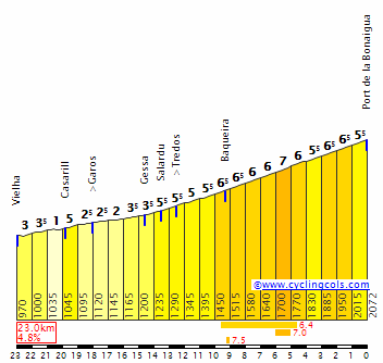
Though it has to be said that the Giro 2010 had some nicely designed stages (Montalcino, L'Aquila, Asolo, Aprica etc.) it had only what, less than 25 km of ITT? (Not counting Corones since it is a MTT)
And even the 15 km of ITT on the final day was mostly up and down Torricelle:
alt_21new_600.jpg

And it also had a 30+ KM TTT which I don't like in GTs.

Giro 2010 was so great because the first 3 days winds splitted things, the rain made stage 7 a classic, a huge break in stage 11 went ahead in rainy conditions and gained huge time so that Liqui had to be aggressive at every point till they took the leaders jersey.
I mean they even attacked in stage 12, resulting in some time gain for Basso, Nibali, Vino, Scarponi and Cunego. They also went ballistic at Asolo and Aprica also Zoncolan brought huge time gaps that year since Liqui needed to be offensive.
 
Giro d'Italia, version 3

My third version of the Giro, and this time a bit more traditional Giro, which means that the Dolomites are actually going to be included. And there will be tough and long medium mountain stages as usual in my GTs. First library posts of my first two Giros.

Giro d'Italia, version 1: part 1
Giro d'Italia, version 1: part 2
Giro d'Italia, version 1, part 3
Giro d'Italia, version 2

Stage 1: Torino - Torino, 21 km ITT

The Giro starts with an ITT in Torino. Instead of a prologue and two ITTs, this version will have a shorter ITT in the first stage, and then a longer one in the last part of the Giro. This ITT starts in Torino and heads into the hills west of the city. The riders will have to climb about 300 height meters to Pino Torionese before descending to the city. The climb isn't especially steep, so strong time trialists who also have some climbing ability (enter Tom Dumoulin) will probably be favorized.

Profile:
ZNvZjQr.png


Map:
MZQ4bBV.png
 
Giro d'Italia: Stage 2: Torino-Imperia, 195 km

The stage starts in Torino, and the route heads southwards more or less the entire stage until the stage finish in Imperia along the Mediterranean coast. The first half of the stage is flat before the climb to Colle de Casotto starts just after passing Mondovi.

After descending from Casotto, there is an almost 20 km long false flat section where the riders gain about 300 height meters to Colle di Nava. The following descent is about 10 km long, and take the riders to the foot of Colle San Bartolemo, the last challenge of the day. From here there is about 25 km to the stage finish in Imperia, mostly downhill, but the last 8-9 km are flat. It could provide an interesting finish where the spinter teams will try to catch any breakaways before the stage finish.

Climbs:
118 km: Colle de Casotto: 10,8 km, 5,6 %
170 km: Colle San Bartolemo: 6,7 km, 5,9 %

Profile:
4pSOhTB.png
[/img]

Map:
fwfAElT.png
 
Giro d'Italia: Stage 3: Imperia - Monte Beigua, 163 km

Stage 3 starts in Imperia, and is the first mountain stage/MTF in this version. The first 40 km of the stage is along the coast until they reach Albegna where the climb to Colle Scravaion starts. The climb is fairly long, but only moderately steep with most kms averaging about 5 % and the steepest kms averages 7 %.

From the top of Scravaion, they descend to Borghetto Santo Spirto and back to the coast. At this point the riders have reached 80 km and are almost halfway. The next part of the stage continues along the coast line, only with a couple of short detours. Just before 130 km the riders pass through Savona, and just after Savona the route turns off the main road and heads for Monte Beigua.

First there is a 6 km uncategorized climb including a 1 km long gentle descent in the middle of the climb. This is followed by an 6 km descent to the village of Pero where the climb to Beigua starts. The climb is pretty tough and could be used for some serious attacks from the GC contenders. The first part is also the steepest, encouaring an early attack. Km 12 to 6 is averaging over 9 %, which favourizes the most typical climbers.

Climbs:
54 km: Colle Scravaion: 13,4 km, 5,1 %
103 km: San Fillippo: 3,6 km, 5,4 %
163 km: Monte Beigua: 13,7 km, 8 %

Profile:
xlKZgta.png


Map:
vJdLrow.png
 
These 2 proposals are short stages that should come off the back of a stage finishing in Vielha (after a tough mountain stage with the last 3 climbs being Portillon-Mirador d'Arres-Pla de Batalher) or Cerler (after the double act of Sahun-Cerler) and the tired legs from the previous stage can mean carnage today. A short stage and it should be tougher than expected.
Both proposals' start and finish locations are the same so I name them as proposal 4a and 4b

Proposal 4a La Pobla de Segur-Port del Comte 112.8 km
https://www.la-flamme-rouge.eu/maps/viewtrack/hd/122194

KOM SPRINTS:
Port del Canto (1st Category, 1718 m, 19.2 Km at 5.4%, Km 19.9)
Coll de la Veça (2nd Category, 1259 m, 15.5 Km at 4.7%, Km 80.1)
Port del Comte (2nd Category, 1745 m, 10.9 Km at 4.1%, Arrive)

Canto:
CantoW.gif

Veça:
https://www.la-flamme-rouge.eu/maps/viewtrack/hd/99366
Port del Comte: (last 9-10 kms of the profile)
Compte.gif


Proposal 4b La Pobla de Segur-Port del Comte 137.2 km
https://www.la-flamme-rouge.eu/maps/viewtrack/hd/122350

KOM SPRINTS:
Port del Canto (1st Category, 1718 m, 19.2 Km at 5.4%, Km 47.1)
Coll de Galliner (2nd Category, 1487 m, 16.5 Km at 4.9%, Km 96.7)
Coll de Port (2nd Category, 1667 m, 12.5 Km at 5.0%, Km 126.9)
Port del Comte (3rd Category, 1744 m, 6.2 Km at 5.1%, Arrive)
Canto:
CantoW.gif

Galliner:
GallinerN.gif

Coll de Port+Port del Comte:
22.JPG
 
That looks like an absolute perfect first MTF in the Giro, chapeau. Never heard of that one. Seems very similar to Passo Lanciano when they climbed it in 2006. Belgua and Blockhaus to the top, a long ITT and some strade bianche before the penultimate weekend and we set.
 
Proposal 5 Viella-Port del Comte 182.3 km
https://www.la-flamme-rouge.eu/maps/viewtrack/hd/122197

KOM SPRINTS:
Port de la Bonaigua (1st Category, 2073 m, 22.3 Km at 4.9%, Km 23.1)
Port del Canto (1st Category, 1718 m, 19.2 Km at 5.4%, Km 92.2)
Coll de Galliner (2nd Category, 1487 m, 16.5 Km at 4.9%, Km 141.8)
Coll de Port (2nd Category, 1668 m, 12.5 Km at 5.0%, Km 172.0)
Port del Comte (3rd Category, 1745 m, 6.2 Km at 5.1%, Arrive)

If you don't like short stages this one is longer with Port de la Bonaigua at the start. The rest of the stage from Sort is the same with proposal 4b. Just like the proposals 4a and 4b it should come off the back of a stage finishing in Vielha or Cerler.
Bonaigua:
BonaiguaW.gif
 
Re:

Valv.Piti said:
That looks like an absolute perfect first MTF in the Giro, chapeau. Never heard of that one. Seems very similar to Passo Lanciano when they climbed it in 2006. Belgua and Blockhaus to the top, a long ITT and some strade bianche before the penultimate weekend and we set.
Monte Beigua was used in Giro Rosa 2013 stage 5 as a MTF. Mara Abbott won the stage and took the pink from Vos. Abbott defended her lead and won the race.
 
I'm passing here just to share my rant about how poorly designed was this year's Giro. Particularly this last week, concentrating the vast majority of the mountain stages.
I'm proposing something: do that again next year, but take it on to the next level: concentrate in the first and a half weeks all the stages for the sprinters and ITTs. From then on, hilly stages and then the mountain stages. Finish the parade on Vesuvious, Zoncolan or wherever the hell they want.


Crappy design.
 
Giro d'Italia: Stage 4: Genova - La Spezia. 162 km

Stage 4 is the first of the typical hilly stages suitable for breakaways. The stage has both start and finish along the Ligurian coastline. After the start in Genova, the first obstacle is the 3rd category climb to Valido di Ruta after about 18 km. After climb this, the next 30 km are flat until passing Sestri Levante where the climb to Passo del Bracco starts. The climb is a two-step climb with a short 2 km flat section in the middle of the climb.

Just before reaching the actual top of Bracco, the riders turns off SS1 and continue south into the rugged terrain just northwest of the famous Cinque Terre. The next two climbs after Bracco comes in rapid sucession, and and the top of the third climb, Valico Guaitarola, the riders is only a few kms from the northernmost of the villages of Cinque Terre, Monterosso al Mare.

From this point there are only about 25 km to La Spezia if going the shortest way, but there is still over 50 km left of the stage. That's because the route takes a loop inland to do the last climb of the stage, Montale Serra, before descending to the coast and the stage finish in La Spezia. The last part from the top of the climb is about 15 km downhill and 15 km flat to the stage finish.

Climbs:
22 km: Valico di Ruta: 3,5 km, 6,2 %
62 km: Passo del Bracco: 11,3 km, 4,7 %
76 km: Valico Guaitarola: 6,4 km, 6,2 %
98 km: Passo del Termine: 7,4 km, 6,6 %
130 km: Montale Serra: 8,2 km, 5 %

Profile:
9EPsyHp.png


Map:
Sb9PCPr.png
 
Giro d'Italia: Stage 5: La Spezia - Pisa: 208 km

Another hilly stage, and quite similar to the stage 4. There is one less climb, but the climbs are longer and steeper. The first 30 km after leaving La Spezia is flat. At this point the riders have left Liguria and entered Toscana. Just after passing Massa, the climb to Passo del Vestito. The last 10 km is fairly regular, mostly 6-7 % average gradient. After descending back to the coast, there is about 15 flat kms before the next climb to Gombitelli starts.

Down from Gambitelli there is another flat section towards Bagni di Lucca where the next climb starts, to Passo del Trebbio. A fairly typical 2nd category climb with 8 kms of climbing and gradients of 6-7 %. The descent is followed by another flat section of about 30 km. After 178 km the climb to Monte Serra starts. The climb is pretty steep with several kms of 9 and 10 % gradient in the middle of the climb. An aggressive rider may try to attack here, especially since the descent is also pretty technical and difficult. After the descent there is a 10 km flat section from Calci to the stage finish in Pisa, famous for it's leaning tower.

Climbs:
50 km: Passo del Vestio: 15,8 km, 6 %
102 km: Gombitelli: 5,4 km, 6,4 %
137 km: Passo del Trebbio: 8,7 km, 6,6 %
186 km: Monte Serra: 8,5 km, 8,4 %

Profile:
MaHSmwY.png


Map:
78Ji6gx.png
 
Giro d'Italia: Stage 6: Pisa - Grosseto, 200 km

Finally, the sprinters will have "their" first stage unless the succeded on stage 1. Starting in Pisa and riding down along the Mediterranean coast, there is hardly any difficulties on this stage except a small "lump" after about 85-90 km. But the climb is fairly easy with gradients of only 3-5 % and it's not categorized. The only thing that could prevent a mass sprint here is some serious side winds, sweeping in from the Mediterranean sea.

Profile:
nz5BfbK.png


Map:
PrbBMp3.png
 
Giro d'Italia: Stage 7: Grosseto - Abbadia San Salvatore, 148 km

This Giro will also contain a mountain stage with double climb of a mountain with multiple approaches. The first version had a double climb of Etna, the second of Monte Grappa, and this time Monte Amiata is to be used. Strangely enough, the tough climbs in Toscana and Emilia Romagna are rarely used in the Giro. Of the climbs in the Apennines it's typically Lanciano/Blockhaus, Terminillo and the Marche climbs that are mosty used. San Pellegrino in Alpe hasn't been used since 2000 and Monte Amiata way back in 1983. However, on this stage they will have to climb Amiata, not just one time, but two times!

From the start in Grosseto, the route head eastwards and into the inland of Toscana. The first 60 kms is flat and after 50 km they are actually just a few kms away from Montalcino, finish of the legendary sterrato stage in 2010. But there is no sterrato in this stage and the first climb to Belvedere is also fairly gentle and never too steep. After some 20 more flat kms, the riders will be at the outskirts of the Monte Amiata massive after about 90 km.

The first part of the first ascent of Amiata starts from Bagni San Fillipo with 7 km of climbing, followed by 3 km downhill to the Abbadia San Salvatore, where the stage later will finish. From here they climb the last 10 km of the eastern approach to Amiata. This is followed by a 10 km descent of the western approach, a few kms of flat, before the second ascent of Amiata from the southwest. This is probably the toughest ascent to Amiata with several kms averaging 9-10 %. The toughest section is 3 kms about halfway in the climb, which could be a could place to attack. The descent to the stage finish in Abbadia San Salvatore should also encourage the best descenders to attack just over the top of Amiata and try to gain some time on the descent to the finish.

Climbs:
75 km: Belvedere: 14,2 km, 4,3 %
111 km: Monte Amiata: 18,4 km, 4,8 %
136 km: Monte Amiata: 11,1 km, 8 %

Profile:
LA5xD1M.png


Map:
LWjoPC3.png
 
European Championships: Velenje, Slovenia

The European Championships in road cycling have existed since 1995. At first, it was only for U23 riders (men and women) and only a road race. The ITT was added in 1997. In 2005, the U19 (juniors) category was introduced, but it wasn't until 2016 that the elite riders could participate.

The races will almost have the same setup as the 2016 edition. The elite women's races have the U23 women's ones integrated in them. Moreover, the elite/U23 women, U23 men and junior men will have the exact same parcours for the ITT, just like the 2016 World Championships.

The European Championships will take place in Velenje, a city in Slovenia with about 25.000 inhabitants. It is located roughly in between Ljubljana and Maribor. As for sports, it is the home town of tennis player Katarina Srebotnik. Furthermore, track and field athlete Jolanda Čeplak (bronze in the 800 m in Athens 2004) grew up in Velenje (nowadays she lives in Celje, where she was born).

Anyway, let's get into the race, starting with the time trials. There is no team time trial, because it's the European Championships. If this were to be a World Championship, the ITT route can be used for the TTT.

Individual time trial - U19 women

The junior women have a short time trial, as usual. The start is in Dobrna, a village with 544 inhabitants (2016). Already after just 1 km, the first climb (to Lokovina) starts. It is 1,4 km @ 4,5%, not that hard but it will be important. If GPSVisualizer (and the altitude data it uses) is right, the last 300 m are about 10%. The only time check is in Vinska Gora (386 inhabitants), after 6,3 km. The second climb (to Lipje) starts shortly after, but it's easy, being only 600 m @ 5,6% (preceded and followed by false flat). There is no descent, just flat roads into Velenje. The time trial is not technical and only has few corners.
Dc8bMxkd.png

ri988T2B.png


Individual time trial - elite/U23 women, U19 men, U23 men
The U19 and U23 men, as well as the women, start in the city of Celje, which is bigger than Velenje, having nearly 38000 inhabitants. The first part of the time trial is flat, with a first time check in Vojnik (~2400 inhabitants). The second time check is in the smallest village that features one, Lemberg pri Novi Cerkvi (135 inhabitants). After that, the riders go through Pristova where they join the route of the U19 women ITT.
TZ6vZ2jY.png

yNwwXOsd.png


Individual time trial - elite men
The most important time trial starts in Šentjur, located east of Celje. The riders go to that city, where the first time check is. Then the riders take a detour from Celje to Vojnik, unlike the U23, U19 and women. It features a few very short ramps, some are about 10% steep but no one is longer than 300 m. It will disrupt the riders' rhythm. After passing through Vojnik, the route is identical to the U23 one, except the final time check, which is in Črnova (401 inhabitants).
V0aUjtLy.png

ROs7NvVH.png
 
Giro d'Italia Stage 7 Ascoli Piceno-Foligno 168.8 km Flat
https://www.la-flamme-rouge.eu/maps/viewtrack/hd/120436

KOM SPRINTS:
Croce di Casale (3rd Category, 726 m, 8.7 Km at 4.6%, Km 24.4)
Passo del Cornello (4th Category, 807 m, 5.8 Km at 4.7%, Km 126.9)
Colle Croce (3rd Category, 872 m, 4.6 Km at 5.3%, Km 135.9)

A mostly flat stage with few obstacles between start and finish, notably Passo del Cornello and Colle Croce can be trouble for pure sprinters.
The intermediate sprints of the day are in Sarnano and Castelraimondo. Castelraimondo was used as the finish of the 5th stage of Tirrenmo-Adriatico 2011 where Gilbert won and Evans took the lead from Gesink.
Foligno was used as the finish of 7th stage in 2016 Giro d'Italia where Andre Greipel won. It was also used as start of the 10th stage of 2017 Giro d'Italia which was an ITT won by Tom Dumoulin.

Sarnano:
MG_1329.jpg


Castelraimondo:
castelria-viewx.jpg


Ascoli Piceno:
images


Foligno:
Giro-Italia-Foligno.jpg
 
European Championships - Velenje, Slovenia

It's time for the road races. They are based on a 19,5 km long circuit in and around Velenje, but the run-in is different for each category.

The circuit
The circuit is 19,5 km long and features no less than 5 climbs. The finish line is on the Tomšičeva cesta, a 2-lane road that gets 3-lane at the finish. There is also a bicycle lane and a footpath at both sides of the road, which gives enough space for the spectators. A GPSVisualizer profile of the circuit only can be found here. I added the numbers above the climbs in MS Paint. The profile is exaggerated, I admit, but it's the best way to show the different climbs.

Already less than 1 km after, the first climb starts. The Cesta na Griču is just 500 m long, but 9,2% average. And it gets pretty steep. After a short descent and some flat, the climb to Bevče (2) starts. The first 700 m are false flat (2,6%), but the second part is 550 m @ 6,2%. The descent is steep, maybe even 15%, but only for 200 meter or something. The road needs to be improved, however.

After the descent, there is a 4 km flat section. It is followed by a two-stepped climb to Kavče (no. 3): first 300 m at 10%, then 200 m downhill, followed by 500 m at 8,4%. Overall it's 1,0 km @ 6,4%. Almost immediately after a very short descent, climb no. 4 starts, to Podkraj pri Velenju. It's one of the less steep climbs, together with the Bevče climb. It's 670 meter at 6,6%, nothing really hard.

The riders have an easier section of 2 km, although there is a very short 14% downhill part. The penultimate climb to Podgorje starts, it's just 530 meters long but 9,3% steep. After the descent, the final 'climb' starts, it's nothing more than a 200 m long 10% ramp. It will take the riders about 40 seconds.

Overall, the circuit features only very short hills. It's a bit like Richmond without the cobbles. It will be interesting if the sprinters can survive or if an attack by a puncheur will be successful.

Road race - elite/U23 women, U19 men, U19 women
The women, as well as both the male and female juniors, will have a short run-in from Celje. However, it is different from the U19/U23/women ITT. When entering Velenje, the U19 women will ride 3 laps, which results in a total distance of around 71,5 km. The women will do 5 laps and the U19 men 6. In all cases, the first two climbs are not ridden in the first lap. At a possible World Championship, the women will have to do 6 laps.
0EsAxSbD.png

fNu4qjJx.png


Road race - U23 men
The U23 men start in Kamnik, a city with about 14.000 inhabitants about 30 km north of Ljubljana. Early in the race there is a 4,8 km @ 5,6 climb, to Podlom. After that, the route is completely flat until Velenje. The riders enter the circuit at the top of the Kavče climb, however, they do the south side of it, which is 3,3 km @ 3,5%. Then they will do 5 laps of the circuit, with the first one being incomplete. At a World Championship, the riders will do an extra lap.
TxMIftJB.png

Kg94XXmv.png


Road race - elite men
The pros start in Ljubljana[/rul], the capital and biggest city (280.000 inhabitants) of Slovenia. They pass through [url=http://lea.hamradio.si/~s57nob/oldhp/pictures/domzale.jpg]Domžale early on. Like in the U23 race, there is an early climb. This one is actually easier, being just 1,2 km @ 6,6% preceded by false flat. At Ločica pri Vranskem the route joins the U23 one. However, the pros will have to do 9 laps of the circuit, the first one being from the top of the Kavče climb. The race is 236 km long. For the World Championships, it will be 2 laps more resulting in a 275 km long course.
KJDJoFI4.png

7u6b8rXc.png
 
Giro d'Italia: Stage 8: Chianciano Terme - Terni, 188 km

Stage 8 starts in Chianciano Terme, just northeast of previous day's stage finish. It's yet again a typical hilly stage in the Apennines, this time taking the riders from Toscana to the capital in Umbria, Terni. The first 35 km of the stage is flat before climbing an uncatgorized climb which gains about 350 height meters over 10 km. The descent takes the riders towards Orvieto, but just before reaching the town, they turn left and start the climb to Colonnetta di Prodo. This is followed directly by the second and toughest climb of the stage, to Civitella del Lago.

The next 50 km are mostly flat, and when the riders pass through Narni which is only about 10 km from Terni along the main road. But instead of approaching Terni directly, they are doing a 35 km loop south and east of the city, doing three climbs in rapid succession, the last climb only about 9 km from the stage finish in Terni. Again a stage for the aggressive riders willing to attack. Jens Voigt would have loved this Giro!

Climbs:
68 km: Colonnetta di Prodo: 8,8 km, 4,9 %
89 km: Civitella del Lago: 9 km, 5,9 %
158 km: Comartino: 3 km, 7 %
168 km: Larviano: 2,5 km, 6,4 %
179 km: San Liberatore: 3,1 km, 5,6 %

Profile:
2JAVwQt.png


Map:
qKiv7aU.png
 
Giro d'Italia: Stage 9: Terni-Palestrina 203 km

Last stage before rest day 1, and this is probably one of the more "open" stages in terms of how it will end. It could be a breakaway win, a typical sprinter winning in a mass sprint or a puncheur beating the more typical sprinters in the sprint. Although there are none categorized climbs, the stage is far from being completely flat. There are small "lumps" the entire stage, and the totalt number of height meters is over 2000. The stage finish is also pretty unconventional. In the last 15 km to the stage finish in Palestrina, the route rises over 400 height meters, but the gradients are very gentle, only 2-3 % most of the time. This would make it more difficult for the typical sprinters to win the stage, and puncheur types with a good sprint could have a decent chance.

Profile:
ccbu814.png


Map:
YE9uTXV.png
 
Giro d'Italia: Stage 10: Termoli - Pescara, 190 km

During the rest day, the the riders have transfered to Molise and the Adriatic coast where stage 10 starts in Termoli. From Termoli the route heads into the more hilly terrain inland. Although the first 50 kms are hilly, the first and only categorized climb doesn't start until 62 km. The top at Torrebruna is reached after 76 km. The following 50 km is also rather hilly before the route heads back to the coast. The last 60 km to the stage finish in Pescara is more or less completely flat and should give a rare chance for the pure sprinters to win a stage.

Climbs:
76 km: Torrebruna: 13,1 km, 5 %

Profile:
a6u1Cj6.png


Map:
NOXEHsN.png
 
Stage 11: Pescara - L'Aquila, 196 km

New medium mountain stage, this time in the Abruzzian Apennines. The stage starts in Pescara by the Adriatic coast, and heads westwards into the mountainous part of Abruzzo. The first 35 km is gentle climbs until the short but steep climb to Civitella Casanova. The terrain continues to be hilly, and after 73 km the riders will have to tackle the very steep climb to Dogli. The steepest km is over 12 %. After descending there is a few flat kms before the next challenging climb, to Valico de Monte Motola. Not as steep as Dogli, but nearly twice the length.

The next 40 km are the easiest part of the stage and is mostly flat. After passing through Onna, the longest climb of the stage, to Valico de Monte Cristo, starts. 15 kms long and at the top of the climb is at heart of the Grand Sasso d'Italia mountains. From here it's possible to turn right and to continue to the hotel at Campo Imperatore, but today's route instead turns left and descends towards L'Aquila. The stage finish isn''t inside the city, but at a hilltop just south of the city, where a departement of the university is located. The last climb isn't very in itself, but with the steep and difficult climbs earlier on the stage, it could prove a challenge for most of the riders.


Climbs:
40 km: Civitella Casanova: 2,5 km, 9,3 %
77 km: Dogli: 4,3 km, 10,1 %
102 km: Valico de Monte Motola: 8,3 km, 8,7 %
156 km: Valico de Monte Cristo: 15,7 km, 5 %
196 km: L'Aquila: 6,8 km, 5 %

Profile:
0BtNT6z.png


Map:
PGqA3U2.png
 
Re:

Valv.Piti said:
That looks like an absolute perfect first MTF in the Giro, chapeau. Never heard of that one. Seems very similar to Passo Lanciano when they climbed it in 2006. Belgua and Blockhaus to the top, a long ITT and some strade bianche before the penultimate weekend and we set.
2013 Giro Donne stage 5: Varazze - Monte Beigua (part 1 of 4)

With Pooley not racing, there's nobody to challenge Abbott who puts on an exhibition to underpin her second overall victory; Vos explodes and loses 5 minutes; 39-year-old former superstar Fabiana Luperini has her last hurrah as a mountain climber before being DQed for an underweight bike, while a 20-year-old Francesca Cauz climbs like a beast and shows the kind of form that she's struggled to recapture since, as she is the female Igor Antón.
 
Giro d'Italia Stage 8 Marsciano-Perugia Individual Time Trial 59.9 km
https://www.la-flamme-rouge.eu/maps/viewtrack/hd/120439
KOM SPRINTS:
Perugia- via Sperandio (3rd Category, 468 m, 2.1 Km at 9.5%, Km 52.0)
Perugia- centro (4th Category, 473 m, 3.8 Km at 4.0%, Arrive)

First 50 kms are mostly flat. Then there is a short but steep climb on the outskirts on Perugia which is 2,1 km at %9.5. After the descent we have a shallow climb to the center of Perugia where the finish is, 3,8 km at %4.
There are time checks at km 17,8, 34,7 and 49,8. Pure climbers should lose lots of time!

Marsciano:
1_z.20140917165959.jpg


Perugia:
place-2015-01-19-6-perugiaabe8f20dfbb9facc439170f48fd927a8.jpg
 
Oct 4, 2015
417
1
3,030
Visit site
Coming back to the forums after a lengthy absence, I've been thinking of posting a Giro route I've been working on, but since there's a Giro being posted already (and also I realized this Giro route is too similar to an older one I posted a while ago for my liking), I've been working on a different fantasy 3-week stage race, in Colombia.
I'll probably only start posting it sometime next week, though, after I'm done finishing up some details (making the stage profiles, double-checking the route, etc).
 
Re:

bp92 said:
Coming back to the forums after a lengthy absence, I've been thinking of posting a Giro route I've been working on, but since there's a Giro being posted already (and also I realized this Giro route is too similar to an older one I posted a while ago for my liking), I've been working on a different fantasy 3-week stage race, in Colombia.
I'll probably only start posting it sometime next week, though, after I'm done finishing up some details (making the stage profiles, double-checking the route, etc).
:confused:
After checking your Giro I don't see any similarities about the first 8 days of our routes. And in the next of the race there is only 1 stage that uses 3 same climbs but other 3 climbs and starting and finishing locations are different. And it is on a different stage as well.
 
Re:

bp92 said:
Coming back to the forums after a lengthy absence, I've been thinking of posting a Giro route I've been working on, but since there's a Giro being posted already (and also I realized this Giro route is too similar to an older one I posted a while ago for my liking), I've been working on a different fantasy 3-week stage race, in Colombia.
I'll probably only start posting it sometime next week, though, after I'm done finishing up some details (making the stage profiles, double-checking the route, etc).

Forever The Best said:
These are some of the key points of the race.
 

TRENDING THREADS