Race Design Thread

Page 204 - Get up to date with the latest news, scores & standings from the Cycling News Community.
Jun 30, 2014
7,060
2
0
My first TdF is also finished, I'll start posting the first few stages durning the next week.
A few informations about my Tour:
-The race starts in Caen.
-Every stage starts and finishes on french soil, but we'll cross the french border on two stages.
-It's an anticlockwise Tour with abouth 100km of ITT and hard mountain stages to balance things, but the whole race will only have 4 uphill finishes.
-The first week was the biggest problem, it's still a bit of a sprint fest with 5 sprint stages, but we have a mid length ITT, an uphill finish on stage 2 and the Pyrenees on stage 8 and stage 9, so it's not a totally boring first week.
 
Feb 3, 2015
284
0
0
Innsbruck is announced to hold Worlds in 2018. I'm already excited about the fact, because I stayed in that beautiful city couple of days last summer and totally enjoyed it. No doubt, this race is gonna have one of the hardest parcours in recent years and year to come as the city is simply squeezed between enormous and magnificient mountains. Geography forces organizers to use ascents and views are just breathtaking!

Thomas Rohregger is said to take part in creating route and there're hints around, that the route is gonna have more that 5000 total elevation gain. I decided to take a shot and squetch my version. Didn't want to make it too hard though, as I want it to be at least a bit unpredictible. There are 7 rounds 36.9 km long each. It gives 258.3 km in total. There two climbs on each round. 3km after the beggining of the round the road starts to lead up. 3.6 km at 7.3% avarange is soild. At the top, in Gotzens, false flat part starts and then there is short bump in Neugotzen. After that, there is a descent right to the host city, with really technical second part. Bridge over the railways and the second hill begins. 4.1 km at 7% with 12% section is gonna be a perfect place to rip this race apart. The closer two the finish, the more damage this climb is gonna do. Before the start to downhill towards Innsbruck, there are 2-3 kms of false flat in beautiful scenery. Last descent is rather fast, but has a 180 turn near the end. From this point there are 7 kms to the finish line. This give a chance for a small group to chase a lone attacker, but they have to start work hard immediately to make it before a serie of sharp turns 2km to go.

Favourites on this route? Nibali, Yates', Aru, Wellens, Kwiatkowski, Mollema, Uran, Rui Costa, Bardet, Alaphillippe, Kelderman, Chaves, Pinot, Rui Costa. Idk if Valverde/jRod are still out there.

Distance:258.3km
Elevation gain: 4658m

Map:


Round:


Full distance profile:
 
Jun 30, 2014
7,060
2
0
They could also use the Hungerburg climb (about 4.5m at 6.8% with a max gradient of 9%) on the northern side of Innsbruck + one of those two climbs.
 
Re:

Mayomaniac said:
My first TdF is also finished, I'll start posting the first few stages durning the next week.
A few informations about my Tour:
-The race starts in Caen.
-Every stage starts and finishes on french soil, but we'll cross the french border on two stages.
-It's an anticlockwise Tour with abouth 100km of ITT and hard mountain stages to balance things, but the whole race will only have 4 uphill finishes.
-The first week was the biggest problem, it's still a bit of a sprint fest with 5 sprint stages, but we have a mid length ITT, an uphill finish on stage 2 and the Pyrenees on stage 8 and stage 9, so it's not a totally boring first week.
Looking forward to it, and I'll wait to post mine, work on my narrative and post a Tour de Franche-Comte in the meantime. PS: my TdF pretty much has the usual week one split between week one and three, in order to avoid the boredom you mentioned :cool: . Hint: how about a PR on week three? Good luck.
 
Nov 18, 2015
111
0
0
This is my second Tour de France. Since most users of this forum have at least a general sense of the area I will be covering; I will provide very limited content about each individual stage. However, I will explain my goals of the route right now. The first objective was to combine old and new features of the Tour. My route stays completely inside of France for the entirety of the race. I also have a couple long mountain stages and a short one to reflect current trends. In the mountain stages I made it a goal to cover the Vosges, Jura, Alps, Masiff Central, Pyrenees and Mount Ventoux, which I successfully did. I also used new (Col de Cuvery, Bouesou) or little used (Prapoutel les 7 Laux, Causse Noir, Pyrenees 2000, Station Val Louren) mountain top finishes which I believe would freshen up the racing. I also wanted to avoid the Tourmalet since it is overused. The last order in the mountains was to bring back Mount Ventoux as a non MTF. I attempted to keep my transfers short, or none whatsoever, and the only exception to this is the transfer to Tours on the second rest day. With the three flat individual time trials of a total of 101 km, I believe this is also a balanced route for riders looking to win the GC. There are also a few stages for the opportunists and puncheurs as well as six sprint stages, so no group of riders will leave empty handed. Well that's about it, I am slowly working on a more interesting project but this held me over until I can start to finalize my next race.


Stage / Distance (km) / Terrain
1 Reims- Metz 190 Flat
2 Metz- Strasbourg 169 Flat
3 Strasbourg- Mulhouse 205 Medium Mountains
4 Mulhouse- Vittel 175 Medium Mountains
5 Epinal- Epinal ITT 25 Flat
6 Vittel- Besancon 158 Flat
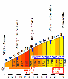
7 Besancon- Col de Cuvery 180 Mountains
8 Anncey- Prapoutel les 7 Laux 196 Mountains
9 Grenoble- Bedoin 235 Mountains
Rest- Orange
10 Orange- Millau- Causse Noir 231 Mountains
11 Rodez- Montpellier 196 Flat
12 Beziers- Narbonne ITT 31 Flat
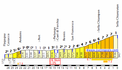
13 Argeles-sur-Mer- Pyrenees 2000 158 Mountains
14 Foix- Station Val Louren 204 Mountains
15 Saint-Lary-Soulan- Oloron-Sainte-Marie 164 Mountains
16 Pau- Bouesou 106 Mountains
Rest- Tours
17 Tours- Nantes 199 Flat
18 Saint-Nazaire- Mur-de-Bretagne 164 Flat
19 Rennes- Alencon 169 Flat
20 Mamers- Le Mans ITT 45 Flat
21 Dreux- Paris 108 Flat

1 Final Climb:2.4 km @ 4.8%
FlDn4N9.png

2
lmfhTRa.png

3
iPADCVH.png

4
hkWR36g.png

5
mtS0Aii.png

6
0ROxo8Y.png

7 Final Climb: 9.6 @ 6.3%
zZXqOBe.png

8 Final Climb:14.9 km @ 7.1%
ogIsW63.png

9 Final Climb: North Side
6FHWWE4.png

10 Final Climb: 6.6 km @ 6.7%
naU0F9O.png

11
2WWdc3f.png

12
Vs2AkaK.png

13 Final Climb: 23.6 km @ 4.9%
n1wi4pj.png

14 Final Climb: 7.4 km @ 8.1%
HxqtSRv.png

15
ELPOq39.png

16 Final Climb: 4.9 km @ 6.7%
UoeQroX.png

17
42oujgA.png

18 Final Climb: 2 km @ 6.9%
KgsKulc.png

19
pml7i5e.png

20
r4aI6pW.png

21
yKjK6rc.png
 
Re: TOC Stage 2

Stage 2: Escondido - Banning 218.2 km

TOC%2BStage%2B2.png


Stage%2B2.png


Our second stage of the Tour of California gets a bit more interesting. We start in Escondido which hosted a TOC stage a couple years back and we get the sprint point out of the way early.

Next it is onto one of the best climbs in California, the Nate Harrison grade to open things up. It averages with a gradient of 8.5 percent for around 14 km and goes up to 5346 feet(around 1630 meters) which is pretty good but the real kicker is that a large portion of the climb is not paved. It should be able to work as it is fairly smooth at the bottom and while it does get a bit rougher towards the top, there should be a smaller group at that stage as a healthy portion of the climb averages around 10%.

The climb could be used as a MTF as there is an observatory not far from the summit and there is the other climb up Palomar Mt. that is fully paved which could be used in a stage that includes both climbs as well. It would be great to see the actual Tour of California use one of the climbs with a MTF as it could be a lot of fun and I think it is fairly realistic.

I put this climb a lot earlier in the stage obviously as I think Stage 2 of a 2 week race is a bit early for a full on MTF up the climb but perhaps in a year where the tour goes from north to south and ends in the area it could be used. The climb in this stage should help form a strong break and maybe a dark horse GC guy ends up being in the break as well sneaking some time perhaps. It also will wear on the riders a bit going into the later stages. Also I just couldn't ignore the climb and go past it as the main purpose of my tour is to show these kinds of climbs off.

I could not find a good profile of the climb but here is a site that talks about the climb quite a bit.

http://www.pjammcycling.com/15.--nate-harrison-grade--ca.html

There is a decent amount of flat after the climb which gives room for the peloton to get it's act together before we hit a few climbs that are not terribly steep but slowly ramp up to the high point on the stage at Pine Cove. The break should be fighting the peloton through this area and it should provide a nice chase through the stage.

After Pine Cove, it is pretty much all downhill towards the finish in Banning and it should be fairly fast, especially towards the end. The descent gets a bit technical towards the end but the road is nice and wide and it isn't too steep.

We finish at the Banning High School as there should be plenty of space there and we don't disrupt too much. It also is pretty much right at the bottom of the descent so we don't have a lot of flat stuck at the end. It should not be a stage for the sprinters and the stage tomorrow is flat for the most part.

2009-04-05-banning-8354.jpg


Banning looking north I believe. I could not find a photo with the finish site visible but I wanted to at least show the town.

What makes the stage unrealistic?

This is another stage that should not be too bad. The biggest things that make this stage unrealistic are the Nate Harrison Grade potentially being a bit too rough for the race and the finish location not being too big as it finishes at a high school.

The Nate Harrison grade should be fine as the road is wide enough even if there is no pavement and there are quite a few climbs that go off of pavement in cycling with many of them being fairly famous like the Finestre. If the climb for any reason does not work, the paved climb up Mt. Palomar road is plenty challenging on it's own and should be a lot of fun.

As for the finishing location, it is a big high school but it could be moved a couple km to finish in the center of Banning if the town is able to plan it out a bit but space should not be an issue.

After this stage, we transfer up to San Bernandino
 
INTRO:

The now defunct Tour de Franche-Comté used to be raced in May from 1979 until 2014 (except in 2009). The first edition was won by Régis Simon. Other noteworthy riders on the final podium included Zbigniew Krasniak (3rd in ’84 – this one is for LS), Laurent Brochard (2nd in ’90), Richard Szostak (3rd in ’92, winner in ’94 – also from Poland – also for LS), Christophe Moreau (3rd in ’93), John Gadret (2nd in ’03), Mathias Frank (3rd in ’07), Romain Barguil (3rd in ’12), or Adam Yates (3rd in ’13). Lack of sponsorship, conflicts with regards to the race calendar, it has now been replaced by a one-day race: the “Classique Bourgogne Franche-Comté”. While I wait (for my turn) to post my second Vuelta a Francia, I decided to have fun and resurrect my home tour.
The entire race remains within the borders of Franche-Comté, and since I can play God, it will be scheduled to give the riders one week recovery between the Sunday finish of the race and the start of the Dauphiné. In many ways, it is the perfect preparation for the preparation of the Tour…

STAGE 1 - LAC DES ROUSSES – ITT – 12.1KM


The first stage consists of a flat 12.1km ITT contested on a Wednesday around the Lac des Rousses.


This pretty small town is the most famous ski destination in the French Jura.


In early June, the snow is long gone, but temperatures remain cold in the Haut-Jura. Unlike on the lower plateaux and the plains, rain is unlikely. ITT specialists may gain 30 seconds to a minute. The question is: can they defend their small advantage in the days to come?
 
STAGE 2 - MOREZ-DOLE – 177KM


KOM : Côte de Pratz (Cat 4) – 6.7km @ 4.9%

The second stage starts in Morez, up the Bienne River from my beloved St-Claude. The two have many characteristics in common, most notably arched bridges over the gorges and a tradition for craftsmanship. In St-Claude, it is pipe making and diamond cutting/polishing, in Morez it is wood toys and spectacles. Alas, watch and clock making are things of the past. Too bad: the remaining and sometimes massive Comtoises clocks (where number 4 is not the usual roman IV, but IIII) are museum pieces. My Grandma/Mamie had one.


The stage will travel down the Bienne valley, then westwards, through easy passes. Only one modest categorized climb on the menu, but today’s order of business isn’t to spice things up with Mayomaniac-like Austrian climbs. For starters, there are none, and it’s only Thursday. Today’s stage is fit for a break, a “baroudeur” may win, but it’s more likely to end in a bunch sprint. Many Grand Masters of the Templar Order came from Franche-Comté, the most famous being Jacques de Molay (his spirit even haunts the CN forums). On this stage, riders will visit Dramelay, home of Bernard de Dramelay, Great Master of the Order, killed during the siege of Ascalon in 1153. In Dramelay, ruins of the old medieval dungeon remain, as well as the Templar Chapel.
 
STAGE 3 – DOLE-BELFORT - 202.4KM


KOM: Côte du Chêne Bénit (Cat 4) – 1.7km @ 5.4%, Col des Chevrères (Cat 2) – 3.6km @ 9.5%

The start takes place in Dole, capital and seat of the parliament of Franche-Comté before the French invasions and subsequent annexation in 1678. As we continue the clock-wise loop on the map, after the ITT and the sprinters’ stage, chances are that the peloton will break apart in the big difficulty of the day, the infamous Col des Chevrères, and a small group will fight for victory.


Yes, vive Thibaut Pinot! In order to secure his participation, I made sure that the race would pass through Mélisey, his hometown. After the Col des Chevrères, with 25K to go, the peloton has to face a descent that is no picnic, and there are a couple of small uncategorized climbs on the way to the finish line in Belfort that could see a decisive attack.


The Territoire de Belfort is, with the Jura, the Doubs, and the Haute-Saône, one of the départements that constitutes the Franche-Comté. I was not going to forget it. Belfort is located in the gap between Jura and Vosges, la trouée de Belfort as we French call it. Belfort is best known for its huge statue of a lion, le Lion de Belfort, a.k.a. Lion de Bartholdi, looking over the city. This is one of the masterpieces by Frederic Auguste Bartholdi (1834-1904), who also designed the Statue of Liberty (Eiffel did the structure), as well as (among others) the statue of Le Marquis de Lafayette, Union Square, Manhattan.
 
STAGE 4 – BELFORT-BESANCON – 160.6KM


KOM: Côte de Chatillon (Cat 3) – 3.3km @ 6.8%, Côte de Deluz (Cat 4) – 1.9km @ 6.7%, Côte de Montfaucon (via La Malatte) (Cat 2) – 2.7km @ 9.1%, Montée de la Chapelle des Buis (Cat 3) – 2.5km @ 7.8%, Côte de Chaudanne (Cat 2) – 2km @ 6.2%.

Up to this point the ITT specialists have probably preserved the advantage gained on Stage 1: they need to hang on for two more days for a well-deserved podium finish, and who knows, the ultimate triumph. The Saturday stage (TV coverage guaranteed) goes from Belfort to the old capital of the province in Roman times: Vesontio. It was from Besançon that Julius Caesar launched his first military campaign in 58 BC. After the destruction of Ariovistus and his German tribes, Caesar went on to become the great historical figure that we all know.


Of the many Roman vestiges in the area, one monument stands out: la Porte Noire, the Black Gate, arc de triomphe symbol of Besançon. The stage is set to see a lot of attacks: a long-range attack is possible, but we’re more likely to see an intense three-climb showdown in the last 20K. The Côte de Montfaucon via La Malatte comes first, from the Doubs River to the old feudal castle of the powerful Lords of Montfaucon. It’s a toughy. The descent is steep, narrow streets, and with no time to rest, the riders hit a wall, the first part of la Montée de la Chapelle des Buis. Sharp descent to the final climb, la Côte de Chaudanne, a.k.a. “ La Montee de Gribaldy”. This climb is raced yearly the day before the start of the TdF, “en ligne” and ITT. The record is 5’29” by Jean-Eudes Desmarets (2” faster than Christophe Moreau BTW). It is dedicated to Jean De Gribaldy, Besançon native (1922-1987), rider, then DS, famous for digging young talents such as Joaquim Agostinho, Steven Rooks, Eric Caritoux, and of course Sean Kelly.


Sean Kelly Interview:

JOURNO: When you broke into the pro ranks, Jean de Gribaldy signed you. Is it really true that he just turned up at your parents’ farm with a contract?
KELLY: Yes, that’s true! […] He made contact with me through the club although I never actually met him but I said no, that I wanted to stay amateur as I was still quite young. So I came home to Ireland, and then he just arrived at my place in October with a contact.
JOURNO: He must have been an amazing guy, what was he like?
KELLY: As a directeur, he was a long way ahead of his time. He had some great ideas. He was 10 years ahead of everyone else on diet. He was clear about what you could and couldn’t eat 10 years before the other teams started to think about it. He was a big influence on my career. In terms of training, he was a long way ahead. In those times, riders did unbelievable miles on the bike. They’d go out and do 5 and 6 hour marathons every day. In my time, he was the guy who’d make you do shorter rides of quality as well as a long mid-week ride. That was 10 years before specialized training programs – I realized this because I’d been through it already, so he had some unbelievable qualities.

RIP Monsieur Le Vicomte.
 
STAGE 5 - BESANCON-SALINS MONT POUPET – 126KM


KOM: Côte d’Amondans (Cat 4) – 2.7km @ 6%, Côte de Crouzet-Migette (Cat 3) – 3.7km @ 6.4%, Côte de Bracon (Cat 3) – 3.7km @ 6.5%, Côte de By (Cat 3) – 4.8km @ 6%, Mont Poupet (Cat 1) – 4.4km % 7.6%


Sunday Bloody Sunday. Final stage of the race. The GC could be decided on the slopes of the Mont Poupet, the southern end of one of the Jura ripples, a rocky outcrop that has resisted erosion. It was my late uncle Alain’s Mont Ventoux. I still see him riding his 10-speed Peugeot like a man possessed (‘ sounds like Phil/Paul).
A finish in Salins makes sense: through the middle ages, the town was the economic capital of Franche-Comté. Its salt works generated so much revenues that lords and princes would often fight over them. It’s a hilly stage, stet up for attacks, the BOD may succeed. On the GC front, the final is a one-two punch. The now-famous Côte de By is the best (paved) setup to the Mont Poupet. No rest after the Côte de by, a little flat to the beginning of the final climb. I cropped the profile to begin at 504m, beginning of the ascent from that side.


This is a tricky climb, and the flat before the last kick can deflate you. Too small of a finish area for a TdF finish, but plenty big enough for a one-week race. Of course, Thibaut ftw.
 
Giro d'Italia

week one (South)
(Mon) rest day
week two until friday (Center)
(Sat) stage 13: Valdobbiadene - Monte Grappa
(Sun) stage 14: Bassano del Grappa - Völs am Schlern
(Mon) rest day

(Tue) stage 15: Bozen - Villanders, 89 km

xSijDtO.png

5bACXOm.png


The final week begins with a very short but intense mountain stage, which features the last mountain top finish of the race. The scene is the valley of the river Eisack and the surrounding mountains. The scenery is gorgeous all day, and the climbs are underused (or not used at all) by the Giro, a recurring theme of this Giro.

Bozen
bozen-luftaufnahme.jpg


The first climb leads to the high plateau of Ritten. The Rittner Straße is an excellent road and climbs from vineyards to the meadows of the plateau.

bahnfahrt-bozen-kollmann-barbian-klobenstein-rennrad.jpg


The climb is 12,8 km long and quite regular (average 6,8%). It culminates at the village of Klobenstein.

klobenstein-mit-dolomiten,589916810.jpg


From here one can enjoy breathtaking views of the Dolomites, like this one (from left to right: Santnerspitze, Schlern, Rosengarten, Latemar). In the middle of the descent there are some flat kilometers at Barbian.

auf-den-saubacher-kofel-wanderung.jpg


The second climb of the day leads to the village of Lajen (7,4 km 8%).

LaionS.gif

Lajen%2002.jpg


The penultimate climb leads to the pittoresque village of Latzfons (7,3 km 7,8%).

CRW_5154.jpg


The descent should not be underestimated, as the road is quite narrow and steep in places.

The final climb is 13,9 km long and at average 8,8% steep. The first and the last kilometers are fairly easy however, which leaves us with a super hard middle section of 6,9 km at 11,2%! No doubt this is where the big guys will come out to play.

The hard part begins just before Villanders, as we leave the main road and take a much smaller (and steeper) road. As a result we don't even get through the village itself.

HRoMjyQ.png


The final 3,5 km are easy and lead to Villanderer Alm, one of the largest Hochalmen in Europe. The finish is at the Gasser Hütte, with plenty of parking space available.

Villanders
D-0868-eisacktal-blick-ueber-st-moritz-sauders-villanders(1).jpg


Villanderer Alm
rinderplatz-villanderer-alm.jpg
 
I still have to finish my slightly modified 2016 Tour de France. So here it is:

Slightly modified Tour de France 2016, part 4: the final

Up until now I haven't changed any start or finish location yet, but that is about to change in stage 18:

Slightly modified Tour de France 2016 stage 18: Sallanches - Saint-Gervais/Le Bettex: 15km, MTT
I changed the finishlocation, but mainly to make better use of Mégève in the next stage. Instead of a 17km long MTT this stage is a 15km long MTT with a bit more flat in the beginning, so that means a higher average gradient of the climb. I used the MTF of the real life stage 19 as finish for this stage.

Map & profile:
1zq981v.jpg


Slightly modified 2016 Tour de France stage 19: Albertville - Mégève: 220km, high mountains
I guess most of us were quite pleased to see the Signal de Bisanne appear in the Tour, but we also can agree that ASO made a terrible use of it, being followed by 40km of descent and flat roads before the final climb. Virtually nothing will happen on it. To make that climb the centerpiece of the stage, a finish in Mégève would be more appropriate, as than there's "only" 25km descent. And that's what I did. But truncating the original stage in Mégève would lead to another junior race length mountain stage, as we have seen far too much the past few years, so I also redesigned the first part of it. I think we now have an suitable queen stage.

Map & Profile:
jb0foi.jpg


Climbs:
Col de Tamié: km 13.5; 8km @ 6.5%; 2nd cat
Col de Forclaz de Montmin: km36; 8.2km @ 8%; 1st cat
Crêt de Châtillon: km73; 17.4km @ 7%; HC
Col de l'Arpettaz: km135; 16.3km @ 7.2%; HC
Col de Grange Neuve: km170.5; 13.6km @ 7.6%; 1st cat There were rumours about a part of this climb that would be used irl, but they never materialized, just like the rumours about the col des champs in last year's TdF.
Col de Bisanne: km194; 12.4km @ 8.2%; HC


Slightly modified 2016 Tour de France stage 20: Mégève - Morzine: 156km, high mountains
I kept the start and finish and a vital part of the stage design, but altered the beginnings and final. I used stage 18 of the 1981 TdF as inspiration.

Map & Profile:
2mgow34.jpg


Climbs:
Col de Romme: km34.5; 9.3km @ 8.3%; 1st cat
Col de la Ramaz: km79; 13.9km @ 7.1%; 1st cat
Col de Joux Plane: km117; 11.6km @ 8.5%; HC
Col de Joux Verte: km140.5; 10km @ 7%; 1st cat


Slightly modified 2016 Tour de France stage 21: Chantilly - Paris: 113km, flat
No changes, although I thought a while about having a +/- 45km long flat itt. Having an itt as final stage would alter the overall race dynamics, but it remains to be seen if it will be in a positive way. And, above all, the travel time between Morzine and Chantilly is too long to be realistic. From Genève or Lyon it would be doable, as it takes just 3h or so with tgv.


Next: my second (and last) Tour without Alps and Pyrenees
 
Jun 30, 2014
7,060
2
0
Sorry, I'll post another race before my first TdF :D
I've decided to create my ownn version of the Giro della Regione Friuli Venezia Giulia.
The race has a long history that goes back until 1962, the 2nd editiion of the race was won by a young Gimondi.
Gimondi is not the only big Italian gc-rider who has won the race before becoming a big star, Claudio Chiappucci won the race in 1984 and Gibo in 1991 and 1993.
In 2012 a young Diego Rosa won the race 31 seconds ahead of Bob Jungels. Brambilla was the winner in 2009 and his arch enemy Ivan Rovny was 3rd in 2013 when the race was won by Jan Polanc.
In 2015 the race only consisted of 3 stages, but I'll go with the format of having 5 stages that the race had in 2012, 2013 and 2014.
Just like the Giro Ciclistico della Valle d'Aosta the race will feature rather short but hard stages. It will be a hard race for young climber and young gc prospects, but we won't see any MTFs.
Stage Pordenone ITT; 20.2km
stage11.png

stage12.png

The race starts with a flat ITT around Pordenone, it's not too technical, so we should get decent gaps.
The ITT starts on Piazzale Duca D'Aosta, probably not the most stunning place in Pordenone, and finishes on the Via dello Stadio near the Stadio Ottavio Bottecchia, it's the stadium of the local Women's Football team and at the same Time a velodrome, you could also have the finish inside the velodrome, that would make the ITT 400m longer and itt would be a nice way to finish an ITT.
dabe512f9ca40d78d64b89dd6235de2d.jpg

Bottecchia-dallalto-e1330205291894.jpg

Pordenone is another one of those countless stunning medieval towns that you can find in Italy.
pordenone.jpg

pordenone.jpg
 

w52

Aug 2, 2015
139
0
0
Tour de France

Stage 18: Orthez - Bordeaux (187.6km)


et18_187_6.png


et18.png


After the last MTF of the race, we have an easy stage between Orthez and Bordeaux. The stage is long and is pan flat, without any categorized climb. This can be an opportunity to a mass sprint or to a isolated group in break to win.

Orthez
images


Bordeaux
bordeaux-placegambetta5.jpg
 
After a long gap again:

Critérium du Dauphiné Stage 3: Bron - Grenoble (210km) (Mon) (''Flat'')

KEyJTsc.png


Xnd7bOf.png


Climbs:
Col de la Placette 6.2km @ 6.2%
Col de Porte 17.5km @ 4.4%
Mont Rolland x2 (not catorgorised)

Sprints:
Grenoble @ 136km
Vizille @ 188.5km

On stage three the riders leave the town of Bron, at the Parc du Parilly. The riders leave the park, where the world championships of my hypthetical parallel cycling world took place when I presented it on the forum. The riders then head in the south east direction from the outskirts of Lyon. The relatively easy (depending on the speed) start continues past the Circuit du Laquais. A small motor racing circuit in the middle of the Isère department. The countryside will then drift slowly into an urban area, north of the city of Grenoble. This is where the flat stops and the hard stuff starts. The riders head throughMoirans followed by Voreppe, at the foot of the first climb of the day. This is the Col de la Placette.
PlacetteS.gif

A short descent slingshots the riders into the Col de Porte. From this side, the climb is actually a Cat 3 but the locals payed the ASO to raise it to a Cat 2 just for this occasion. In the Hypothetical cycling world anyway!
PorteN.gif

At the bottom the riders will reach the city of Grenoblefor the prime. After this the riders head out south to the uncatorgorised climb of Mont Rolland. As featured in the 2011 Tour de France final TT won by Tony Martin. The riders then head back into the city of Grenoble to cross the finish for the final time before the finish. They complete the same loop again but have a prime in the town of Vizille. Then it is once again back into the city of Grenoble for the sprint at the end of a 'flat' day.

Bron: (Lyon)
images


Grenoble:
7486_grenoble_veduta_aerea_della_citta.jpg
 
w52, how far are you from posting the final stages of your TdF? Since Mayomaniac will delay his Grand Depart, I can probably squeeze my TdF#2 (a.k.a. Vuelta a Francia) all in one shot (the first/last one took me two hours to post). I have all the material ready to go, the narrative should be finalized and the ASO-like map ready within 24 hours.

w52, I like the old school sprint finish in Bordeaux ;) .
 

w52

Aug 2, 2015
139
0
0
@tonton i will post stage 19 now. If i have time i will finish it tomorrow :)

Tour de France

Stage 19: Libourne - Angouleme (175.6km)


et19_175_6.png


et19.png


Stage 19 will be another boring stage in this race. More than 175km of flat terrain that should be one of that days where a group can win with 20 minutes of advance to the main bunch. It's a good stage to rest the legs because stage 20 will be the final opportunity to change the GC.

Libourne
680x250_libourne.jpg


Angouleme
angouleme-skyline.jpg
 

w52

Aug 2, 2015
139
0
0
Tour de France

Stage 20: Lascelle - Murat (38.4km ITT)


et20_38_4.png


et20.png


Stage 20 is the last "competitive" stage of the race and also the last opportunity for someone try to change things in the GC. It's ITT day and it will be a hard ITT.
The 38.4km route starts in the small village of Lascelle, close to the Lac des Graves.

Lascelle
2440950.jpg


This ITT is hard just after the start, being the first +/-9km in false flat with small gradients. This phase finishes with the tough climb to the Col du Perthus, a cat.2 that is short but really steep. The top of Perthus is also the first intermediate point where we can see who is gaining or losing time

Col-du-Perthus_profile.jpg


After the first climb, there is a short descent to Saint Jacques-des-Blats where starts the climb to Le Lioran through the Col de Font de Cere.
Finished the climb is a short and fast descent until La Bougearde, where is the the secound intermediate point. Until the finish there are more less 8km of flat to Murat where the specialists can make differences or make the gaps created in the climbing part shorter.

Murat
27997168.jpg


This ITT, like a previously said, is hard and the specialists like Froome won't make huge gaps in here. We have to remember that is stage 20 and the energy levels are scarce even to the main GC contenders and a guy in good shape can do better than a TT expert.
 
Jun 30, 2014
7,060
2
0
Stage 2: Pordenone - Tolmezzo; 151km
stage21.png

stage22.png

The 2nd stage starts in Pordenone, the first 20km are false flat, then the brutal Piancavallo climb starts,13.8km at 8% with a max. gradient of 13%.
PiancavalloE.gif

36718129.jpg

It's the first climb of the race but its a nasty one, so we should get a strong breakaway.
After the 15km long descent that features a few technical sections we have about 35km of false flat before the first easy ramp of the next climb, I Piani, starts. The actual climb, the 2nd ramp, is about 3.6km at 6.9%.
PianiW.gif

The following descent is short and nothing special, you have a section of false flat in the middle part,the we have about 12km of false flat before the final climb starts.
It's Sella Chianzutan, the actual climb is 11.1km at 5.4% with a max. gradient of 9%.
ChianzutanS.gif

2013-07-22%20Urlaub%20A-I%205344%20Sella%20Chianzutan.JPG

After the descentt we still have 10km of false flat until we reach the finish line in Tolmezzo, a small town that is the birthplace of the Italian Cross-country skiing legend Giorgio Di Centa. :)
Tolmezzo:
900352.jpg

This one could be interesting, after the ITT we should already have decent gaps and with such a hard climb after 20km we should get a pretty strong breakaway. The final 10km are false flat the next stage is even harder, so I don't expect any moves from the big gc-favourites, but this one should be a U-23 race, so the teams shouldn't be too strong and therefore someone could gain a few minutes on gc in the breakaway, it could be a rather chaotic stage and hard to control.
 
Giro d'Italia

week one (South)
(Mon) rest day
week two until friday (Center)
(Sat) stage 13: Valdobbiadene - Monte Grappa
(Sun) stage 14: Bassano del Grappa - Völs am Schlern
(Mon) rest day
(Tue) stage 15: Bozen - Villanders

(Wed) stage 16: Eppan - Salò, 168 km

l5J6DIj.png

dM6vBRW.png


Transitional stage from Trentino to Lombardia, which should be won by a breakaway group. The highlight should be the final 60 km along the shores of Lago di Garda, especially the plateau of Tremosine.

BAZZANEGA-HOTEL1a.jpg

NX4VGBL.jpg

tU51vQ0.jpg


Eppan
Eppan_St.Pauls.jpg


Salò
QS9DqVv.jpg
 

TRENDING THREADS